Overview
|
Thunderstorms began developing over northwest Iowa shortly after midnight on August, 2019. While storms started out as discrete storms producing mainly small hail and locally heavy rainfall, they gradually merged and the threat transitioned to a wind and tornado event. By 4 to 7 am storms were pushing across central Iowa, producing areas of straight line wind damage with several embedded tornadoes along the front edge of the line. As storms continued to push south the tornado threat diminished, but storms continued to produce heavy rain and gusty winds across the line of storms. |
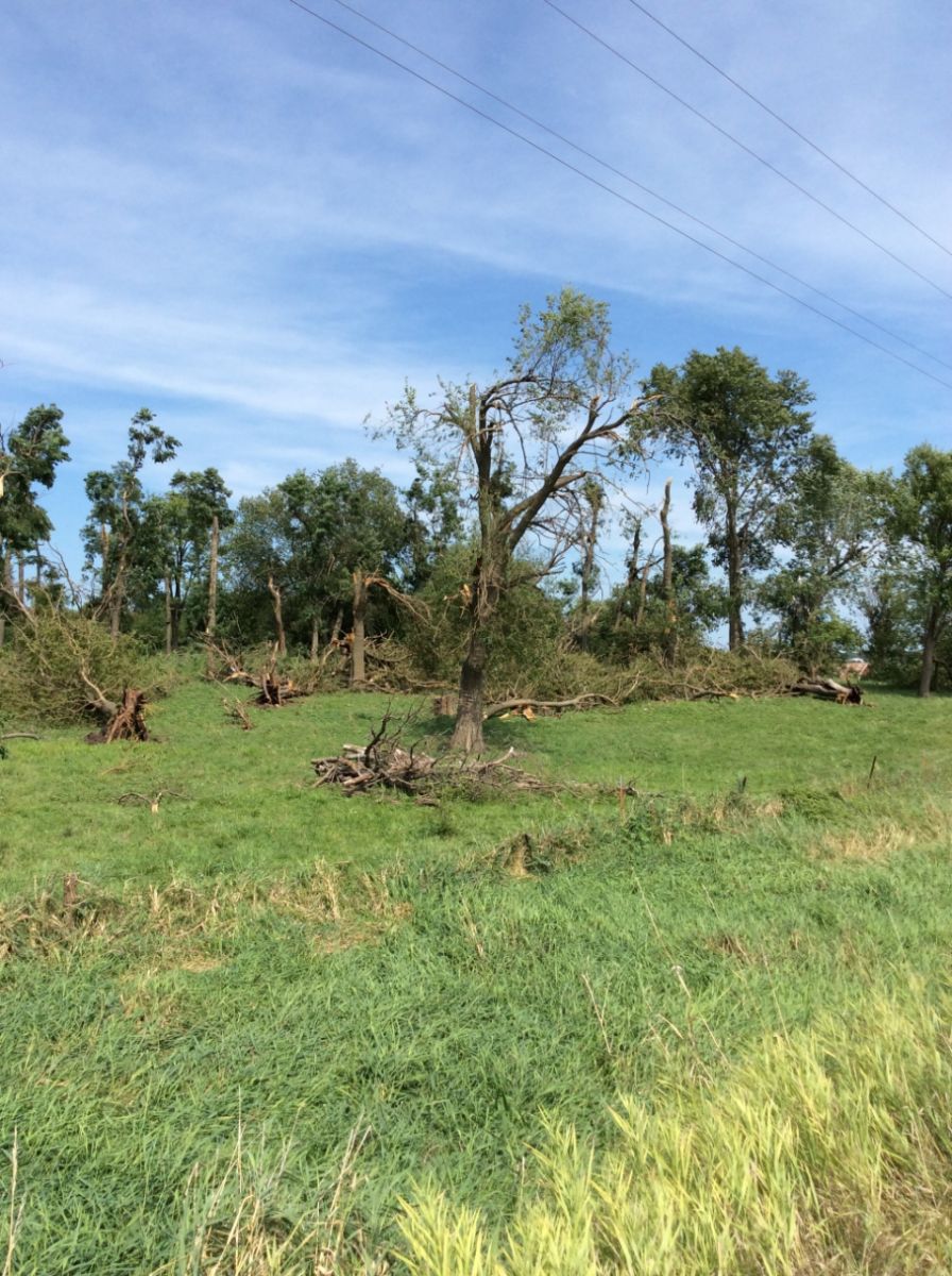 Tree damage just west of Tracy, IA |
Tornadoes:
|
Tornado - Tracy
Track Map 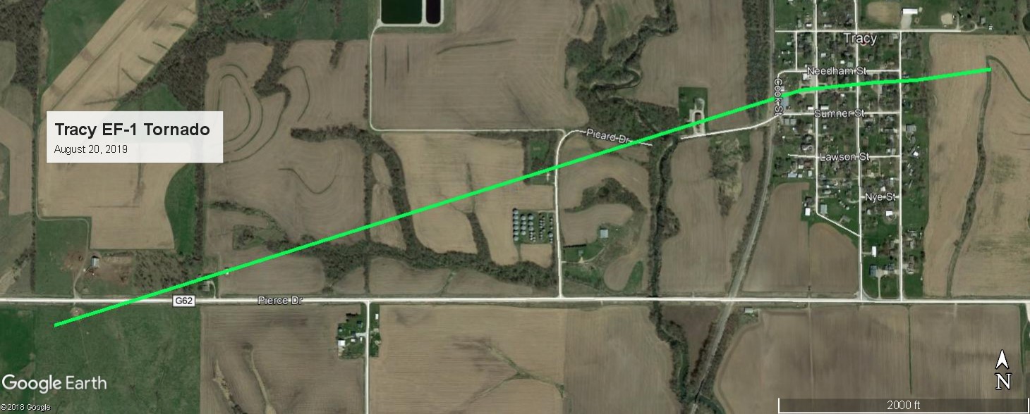 
Downloadable KMZ File |
||||||||||||||||
|
Tornado - Lacona
Track Map 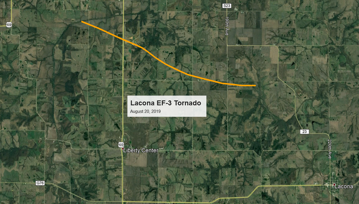
Downloadable KMZ File |
||||||||||||||||
 |
 |
 |
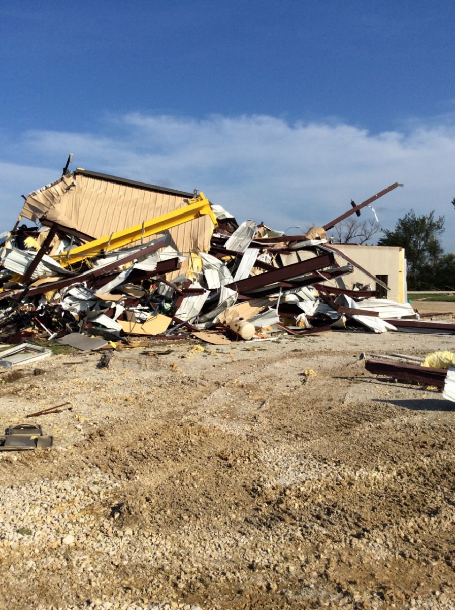 |
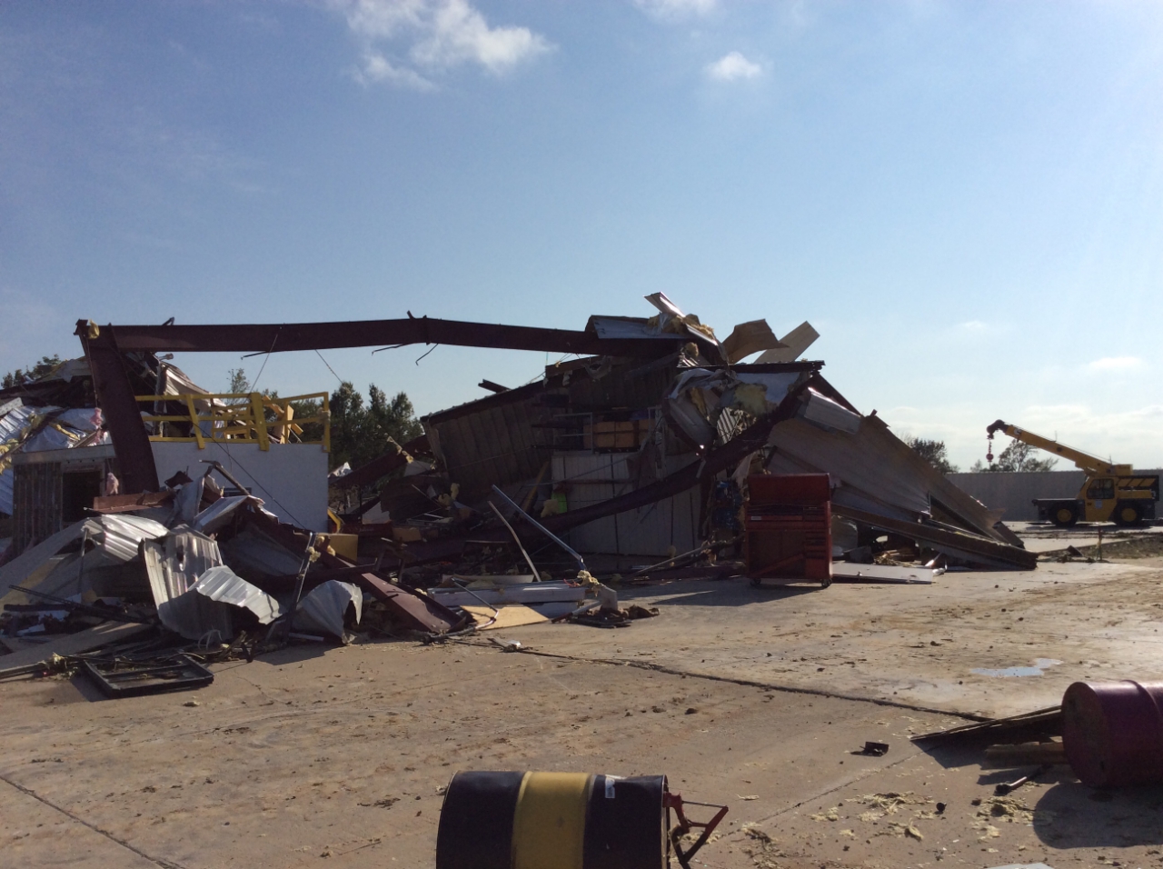
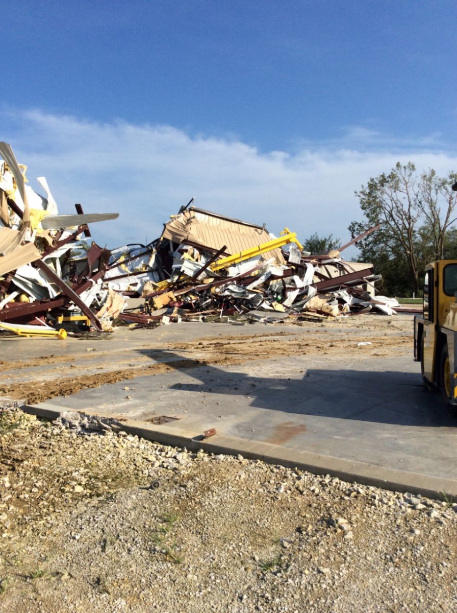
| Damage at the Operator Engineers Training Facility with metal building systems nearly completely destroyed. (NWS Des Moines Storm Survey) |
Damage at the Operator Engineers Training Facility with metal building systems nearly completely destroyed. This photo shows the complete separation of metal floor footing from concrete (NWS Des Moines Storm Survey) |
Damage at the Operator Engineers Training Facility with metal building systems nearly completely destroyed. (NWS Des Moines Storm Survey) |
Damage at the Operator Engineers Training Facility with metal building systems nearly completely destroyed. (NWS Des Moines Storm Survey) |
|
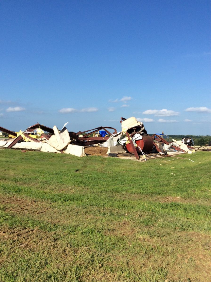
Tornado - Badger Creek State Park
Track Map 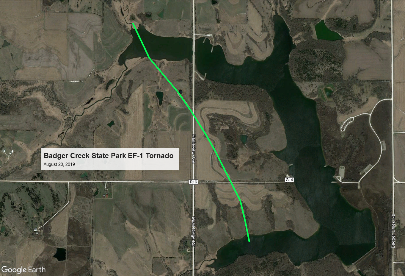
Downloadable KMZ File |
||||||||||||||||
|
Tornado - LOCATION
Track Map
Downloadable KMZ File |
||||||||||||||||
The Enhanced Fujita (EF) Scale classifies tornadoes into the following categories:
| EF0 Weak 65-85 mph |
EF1 Moderate 86-110 mph |
EF2 Significant 111-135 mph |
EF3 Severe 136-165 mph |
EF4 Extreme 166-200 mph |
EF5 Catastrophic 200+ mph |
 |
|||||
Storm Reports
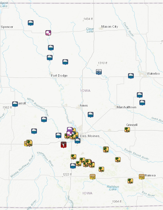
August 20, 2019 Storm Reports over central Iowa
PRELIMINARY LOCAL STORM REPORT...SUMMARY
NATIONAL WEATHER SERVICE DES MOINES IA
148 PM CDT TUE AUG 20 2019

..TIME...   ...EVENT...      ...CITY LOCATION...     ...LAT.LON...
..DATE...   ....MAG....      ..COUNTY LOCATION..ST.. ...SOURCE....
            ..REMARKS..

0635 AM     HEAVY RAIN       EAGLE GROVE             42.67N 93.90W
08/20/2019  E4.50 INCH       WRIGHT             IA   PUBLIC

            VIA SOCIAL MEDIA.

0854 AM     TSTM WND DMG     4 SW MILO               41.23N 93.46W
08/20/2019                   WARREN             IA   PUBLIC

            REPORT FROM MPING: TREES UPROOTED OR
            SNAPPED; ROOF BLOWN OFF.

0807 AM     HEAVY RAIN       1 W NEW VIRGINIA        41.18N 93.75W
08/20/2019  M2.00 INCH       WARREN             IA   TRAINED SPOTTER

            STORM TOTAL.

0605 AM     TORNADO          1/2 N LACONA            41.20N 93.39W
08/20/2019                   WARREN             IA   EMERGENCY MNGR

            LAW ENFORCEMENT CONFIRMED TORNADO HIT
            GROUND. BUILDINGS DEMOLISHED NORTH OF
            LACONA.

0605 AM     TSTM WND DMG     LACONA                  41.19N 93.38W
08/20/2019                   WARREN             IA   EMERGENCY MNGR

            SEVERAL STRUCTURES DAMAGED INCLUDING MACHINE
            SHEDS AND GRAIN ELEVATORS, POWER LINES DOWN.
            TIME ESTIMATED.

0605 AM     TORNADO          1/2 N LACONA            41.20N 93.39W
08/20/2019                   WARREN             IA   EMERGENCY MNGR

            LAW ENFORCEMENT CONFIRMED TORNADO HIT
            GROUND. BUILDINGS DEMOLISHED NORTH OF
            LACONA.

0605 AM     TORNADO          1/2 N LACONA            41.20N 93.39W
08/20/2019                   WARREN             IA   EMERGENCY MNGR

            LAW ENFORCEMENT CONFIRMED TORNADO HIT
            GROUND. BUILDINGS DEMOLISHED NORTH OF
            LACONA.

0603 AM     TORNADO          4 S MILO                41.23N 93.44W
08/20/2019                   WARREN             IA   EMERGENCY MNGR

            STRUCTURE DAMAGE TO OUTBUILDINGS, POWER
            LINES DOWN NORTHWEST OF LACONA, IA. TIME
            ESTIMATED.

0603 AM     TORNADO          4 S MILO                41.23N 93.44W
08/20/2019                   WARREN             IA   EMERGENCY MNGR

            STRUCTURE DAMAGE TO OUTBUILDINGS, POWER
            LINES DOWN NORTHWEST OF LACONA, IA. TIME
            ESTIMATED.

0603 AM     TORNADO          4 S MILO                41.23N 93.44W
08/20/2019                   WARREN             IA   EMERGENCY MNGR

            STRUCTURE DAMAGE TO OUTBUILDINGS, POWER
            LINES DOWN NORTHWEST OF LACONA, IA. TIME
            ESTIMATED.

0602 AM     TSTM WND DMG     SAINT MARYS             41.31N 93.74W
08/20/2019                   WARREN             IA   PUBLIC

            REPORT FROM MPING: 1-INCH TREE LIMBS BROKEN;
            SHINGLES BLOWN OFF.

0601 AM     TSTM WND DMG     6 W LACONA              41.20N 93.50W
08/20/2019                   WARREN             IA   EMERGENCY MNGR

            STRUCTURE DAMAGE TO OUTBUILDINGS, HAY BALES
            BLOWN ACROSS/ON TO ROAD, POWER LINES DOWN.
            TIME ESTIMATED.

0600 AM     TSTM WND DMG     4 SSW MILO              41.24N 93.46W
08/20/2019                   WARREN             IA   PUBLIC

            LARGE TREE FELL ON HOUSE. 24 FOOT SHED BLOWN
            AWAY AND WRAPPED AROUND A TREE. MULTIPLE
            LARGE TREES UPROOTED AND SNAPPED. MOBILE
            CAMPER TRAILER BLOWN OVER ON ITS SIDE.
            MORTON BUILDING LOST PART OF ITS ROOF. TIME
            ESTIMATED.

0527 AM     TSTM WND DMG     7 S INDIANOLA           41.26N 93.57W
08/20/2019                   WARREN             IA   TRAINED SPOTTER

            1 MILE SOUTH LAKE AHQUABI STATE PARK 3 FT
            WIDE, 40-50FT TALL MAPLE TREES DOWN, PARTIAL
            ROOF MISSING ON SHED, WINDOWS BLOWN OUT OF
            OUTBUILDINGS, WOOD SWING SET FLIPPED OVER.
            TIME IS ESTIMATED.

0500 AM     TSTM WND DMG     5 E NEW VIRGINIA        41.21N 93.64W
08/20/2019                   WARREN             IA   PUBLIC


0658 AM     TSTM WND DMG     BLAKESBURG              40.96N 92.64W
08/20/2019                   WAPELLO            IA   PUBLIC

            REPORT FROM MPING: 1-INCH TREE LIMBS BROKEN;
            SHINGLES BLOWN OFF.

0653 AM     TSTM WND GST     OTTUMWA                 41.02N 92.42W
08/20/2019  M58 MPH          WAPELLO            IA   MESONET

            AUTOMATED RWIS STATION ON US 63.

0700 AM     HEAVY RAIN       TRAER                   42.20N 92.46W
08/20/2019  M2.32 INCH       TAMA               IA   CO-OP OBSERVER


0700 AM     HEAVY RAIN       1 NNW CLUTIER           42.09N 92.41W
08/20/2019  M3.45 INCH       TAMA               IA   CO-OP OBSERVER


0600 AM     HEAVY RAIN       2 N MAXWELL             41.92N 93.41W
08/20/2019  M3.10 INCH       STORY              IA   PUBLIC


0655 AM     TSTM WND DMG     3 SSE GRINNELL          41.70N 92.70W
08/20/2019                   POWESHIEK          IA   LAW ENFORCEMENT

            HOUSE, BARN, AND OUTBUILDINGS HEAVILY
            DAMAGED BY WIND, MULTIPLE TREES DOWN. TIME
            ESTIMATED.

0136 PM     HEAVY RAIN       2 W URBANDALE           41.64N 93.77W
08/20/2019  M2.30 INCH       POLK               IA   PUBLIC

            STORM TOTAL.

0754 AM     TSTM WND DMG     1 E CLIVE               41.60N 93.75W
08/20/2019                   POLK               IA   PUBLIC

            REPORT FROM MPING: TREES UPROOTED OR
            SNAPPED; ROOF BLOWN OFF.

0700 AM     HEAVY RAIN       1 E WINDSOR HEIGHTS     41.60N 93.70W
08/20/2019  M2.07 INCH       POLK               IA   PUBLIC


0700 AM     HEAVY RAIN       DES MOINES INT AIRPORT  41.54N 93.66W
08/20/2019  M2.35 INCH       POLK               IA   OFFICIAL NWS OBS


0626 AM     LIGHTNING        1 NW GRIMES             41.70N 93.81W
08/20/2019                   POLK               IA   EMERGENCY MNGR

            HOUSE FIRE STARTED BY LIGHTNING.

0600 AM     TSTM WND DMG     URBANDALE               41.64N 93.74W
08/20/2019                   POLK               IA   BROADCAST MEDIA

            SEVERAL SMALL AND MEDIUM SIZE TREE BRANCHES
            DOWN.

0549 AM     TSTM WND DMG     1 NW JOHNSTON           41.69N 93.75W
08/20/2019                   POLK               IA   PUBLIC


0529 AM     TSTM WND DMG     2 NNE WINDSOR HEIGHTS   41.63N 93.70W
08/20/2019                   POLK               IA   NWS EMPLOYEE

            TREE DOWN OVER 61ST STREET SOUTH OF MERLE
            HAY MALL. TIME ESTIMATED FROM RADAR.

0644 AM     HEAVY RAIN       6 SW RINGSTED           43.22N 94.57W
08/20/2019  E3.25 INCH       PALO ALTO          IA   PUBLIC

            VIA BROADCAST MEDIA.

0640 AM     TSTM WND DMG     1 WNW LAKE RED ROCK     41.42N 93.11W
08/20/2019                   MARION             IA   LAW ENFORCEMENT

            SEMI WAS BLOWN OVER ON MILE LONG BRIDGE
            NORTH OF KNOXVILLE. TIME ESTIMATED.

0630 AM     TSTM WND DMG     1 W LAKE RED ROCK       41.41N 93.11W
08/20/2019                   MARION             IA   PUBLIC


0616 AM     TSTM WND DMG     4 SE HARVEY             41.27N 92.88W
08/20/2019                   MARION             IA   BROADCAST MEDIA

            WHO-TV VIEWER SHARED VIDEO OF WIDESPREAD
            DAMAGE IN THE TOWN OF TRACY. SEVERAL LARGE
            TREE BRANCHES, OUTDOOR SHEDS, AND DEBRIS ALL
            OVER THE PLACE. TIME ESTIMATED BY RADAR.

0521 AM     TORNADO          4 SSE VAN METER         41.48N 93.93W
08/20/2019                   MADISON            IA   EMERGENCY MNGR

            RATING TO BE DETERMINED.

0521 AM     TORNADO          6 SE DE SOTO            41.48N 93.93W
08/20/2019                   MADISON            IA   EMERGENCY MNGR

            RATING TO BE DETERMINED.

0520 AM     TORNADO          3 SSE VAN METER         41.49N 93.93W
08/20/2019                   MADISON            IA   TRAINED SPOTTER

            MODERATE ROOF DAMAGE WITH PARTIAL ROOF
            COLLAPSE, EXTERIOR WALL COLLAPSE OF
            OUTBUILDING. LARGE TREE KNOCKED DOWN.

0520 AM     TORNADO          3 SSE VAN METER         41.49N 93.93W
08/20/2019                   MADISON            IA   TRAINED SPOTTER

            MODERATE ROOF DAMAGE WITH PARTIAL ROOF
            COLLAPSE, EXTERIOR WALL COLLAPSE OF
            OUTBUILDING. LARGE TREE KNOCKED DOWN.

0518 AM     TSTM WND DMG     3 SSE VAN METER         41.49N 93.93W
08/20/2019                   MADISON            IA   EMERGENCY MNGR

            HALF OF A HOUSE HAS RECEIVED CONSIDERABLE
            DAMAGE...POSSIBLE TORNADO.

0615 AM     TSTM WND GST     3 W CHARITON            41.02N 93.37W
08/20/2019  M58 MPH          LUCAS              IA   AWOS

            AWOS STATION KCNC CHARITON AIRPORT.

0610 AM     TSTM WND DMG     4 NE WILLIAMSON         41.13N 93.20W
08/20/2019                   LUCAS              IA   DEPT OF HIGHWAYS

            ROAD CLOSED DUE TO DOWNED POWER LINES. TIME
            ESTIMATED VIA RADAR.

0912 AM     HAIL             ALGONA                  43.08N 94.23W
08/20/2019  E1.50 INCH       KOSSUTH            IA   EMERGENCY MNGR


0842 AM     HEAVY RAIN       LIVERMORE               42.87N 94.18W
08/20/2019  M2.25 INCH       HUMBOLDT           IA   PUBLIC


0700 AM     HEAVY RAIN       1 N DAKOTA CITY         42.73N 94.20W
08/20/2019  M3.45 INCH       HUMBOLDT           IA   CO-OP OBSERVER


0700 AM     HEAVY RAIN       1 NE IOWA FALLS         42.53N 93.25W
08/20/2019  M3.68 INCH       HARDIN             IA   CO-OP OBSERVER


0700 AM     HEAVY RAIN       GUTHRIE CENTER          41.68N 94.50W
08/20/2019  M3.95 INCH       GUTHRIE            IA   CO-OP OBSERVER


0700 AM     HEAVY RAIN       JAMAICA                 41.85N 94.31W
08/20/2019  M2.29 INCH       GUTHRIE            IA   NWS EMPLOYEE


0520 AM     TSTM WND GST     ADAIR                   41.50N 94.64W
08/20/2019  M60 MPH          GUTHRIE            IA   MESONET

            AUTOMATED RWIS SITE ON INTERSTATE 80.

0515 AM     TSTM WND DMG     3 ENE ADAIR             41.52N 94.60W
08/20/2019                   GUTHRIE            IA   EMERGENCY MNGR

            TREES BLOWN OVER ON WHITE POLE ROAD. CAR RAN
            INTO DOWNED TREES. LOCATION AND TIME
            ESTIMATED.

0700 AM     HEAVY RAIN       DIKE                    42.47N 92.63W
08/20/2019  E2.25 INCH       GRUNDY             IA   BROADCAST MEDIA

            VIA KWWL TV.

0700 AM     HEAVY RAIN       ADEL                    41.62N 94.03W
08/20/2019  M2.15 INCH       DALLAS             IA   CO-OP OBSERVER


0619 AM     HEAVY RAIN       ADEL                    41.62N 94.03W
08/20/2019  E2.55 INCH       DALLAS             IA   TRAINED SPOTTER


0528 AM     HAIL             3 SW GRIMES             41.65N 93.82W
08/20/2019  U0.75 INCH       DALLAS             IA   PUBLIC

            REPORT FROM MPING: DIME (0.75 IN.).

0500 AM     TSTM WND DMG     WAUKEE                  41.61N 93.86W
08/20/2019                   DALLAS             IA   PUBLIC

            12IN TREE DOWN IN WAUKEE - VIA SOCIAL MEDIA.
            TIME ESTIMATED VIA RADAR.

0700 AM     HEAVY RAIN       CARROLL                 42.07N 94.87W
08/20/2019  M3.45 INCH       CARROLL            IA   CO-OP OBSERVER

            RADIO STATION KCIM.

0525 AM     TSTM WND DMG     3 E ADAIR               41.50N 94.59W
08/20/2019                   ADAIR              IA   LAW ENFORCEMENT

            SEMI BLOWN OVER AT REST AREA ON INTERSTATE
            80.

0517 AM     TSTM WND DMG     3 E ADAIR               41.50N 94.59W
08/20/2019                   ADAIR              IA   LAW ENFORCEMENT

            3 SEMIS BLOWN OVER AT WEST BOUND REST STOP
            NEAR MM80 ON INTERSTATE 80. 2 SEMIS BLOWN
            OVER IN EAST BOUND TRAFFIC LANES IN SAME
            AREA. TIME ESTIMATE UPDATED.
 |
Media use of NWS Web News Stories is encouraged! Please acknowledge the NWS as the source of any news information accessed from this site. |
|

