Wildfire smoke will push into the Midwest, worsening air quality. A frontal system brings severe storms from the Northern Plains to the Mid‑Atlantic the next few days. Heavy Gulf Coast rain is possible as Tropical Depression Two has formed, while monsoonal storms persist in the Southwest with heavy rainfall. Hazardous heat expands from the Plains into the Lower Mississippi Valley. Read More >
Overview
|
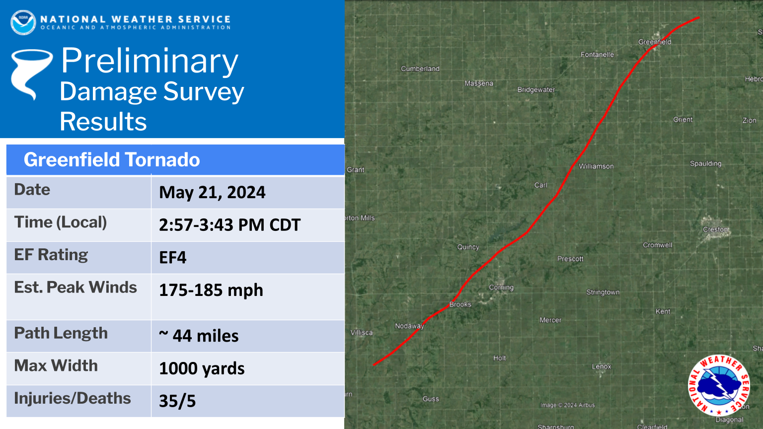
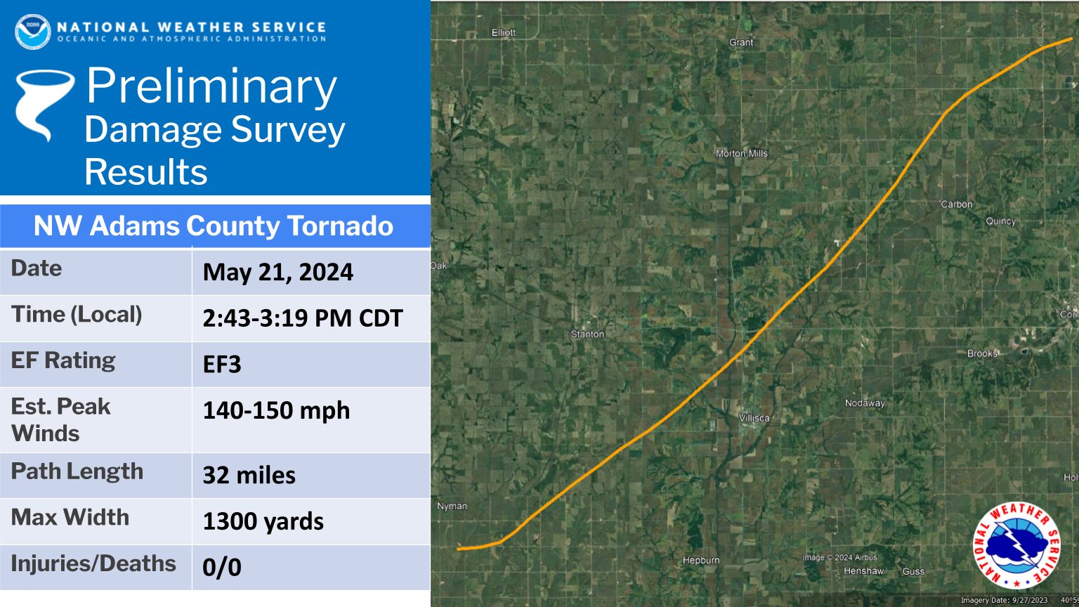
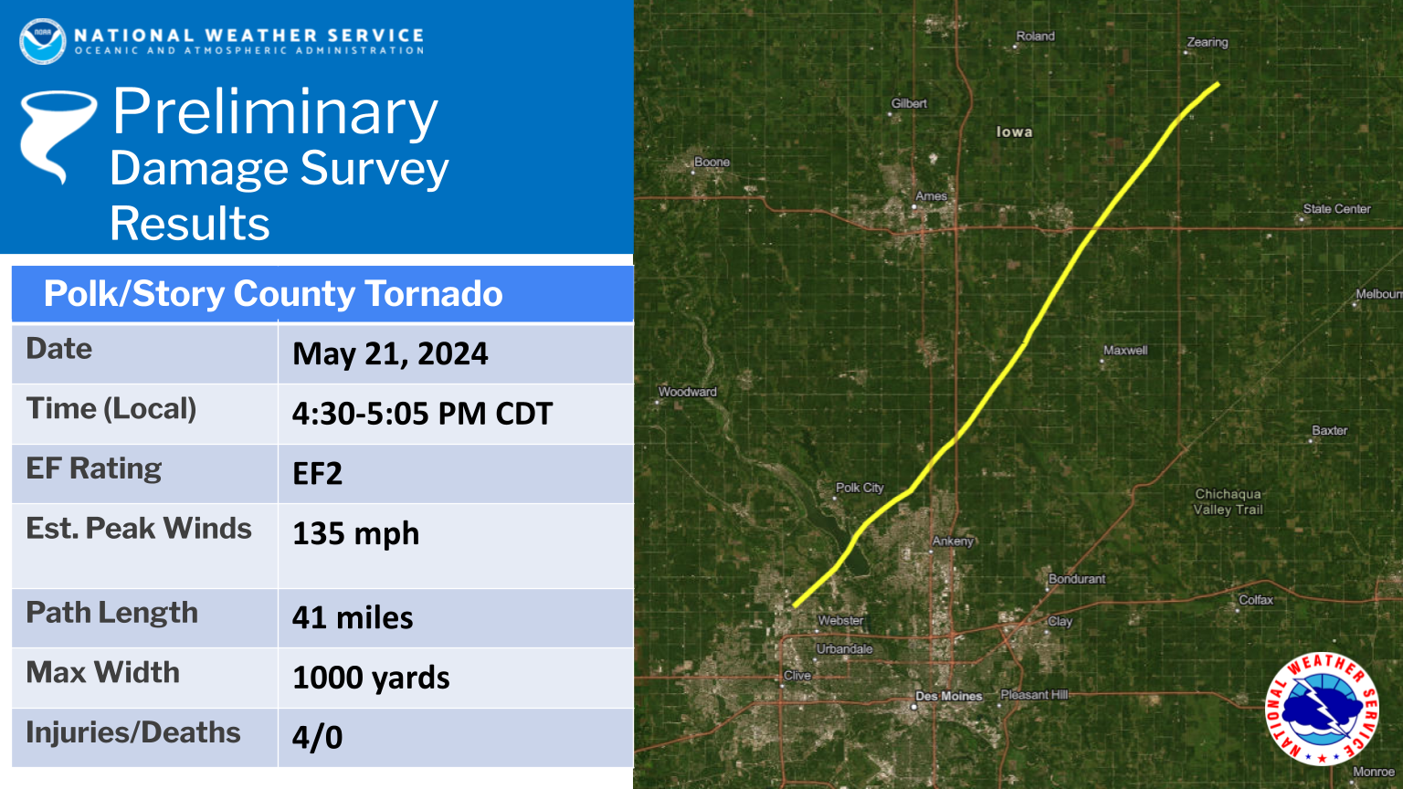
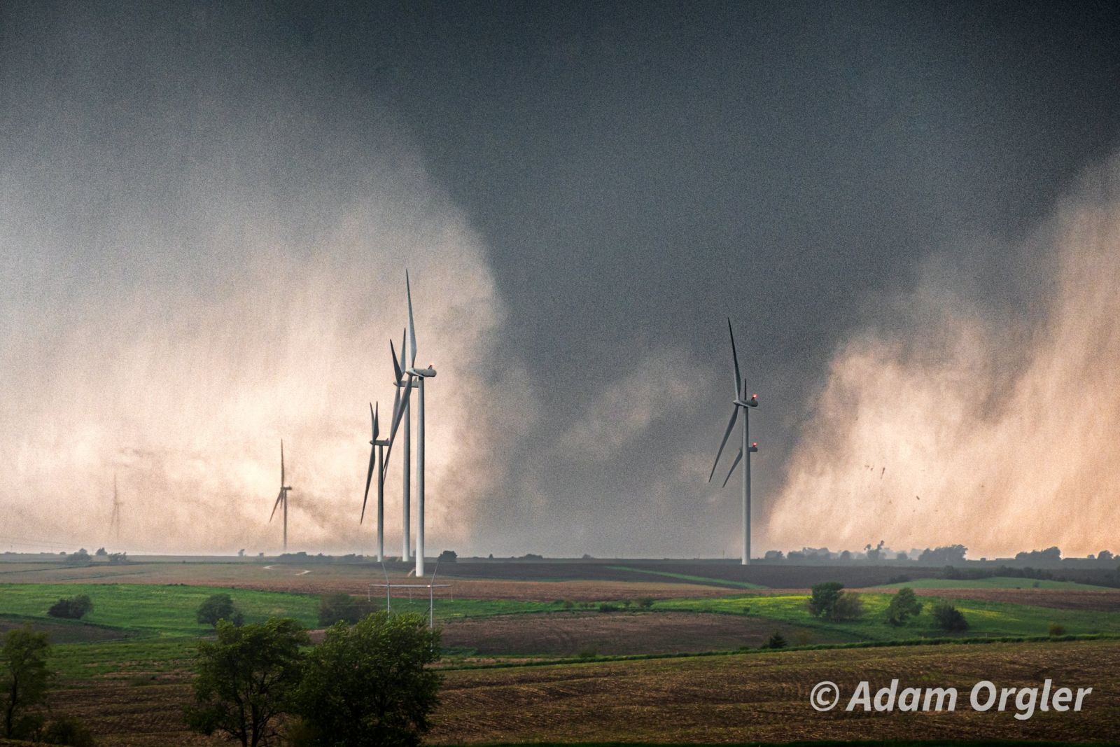
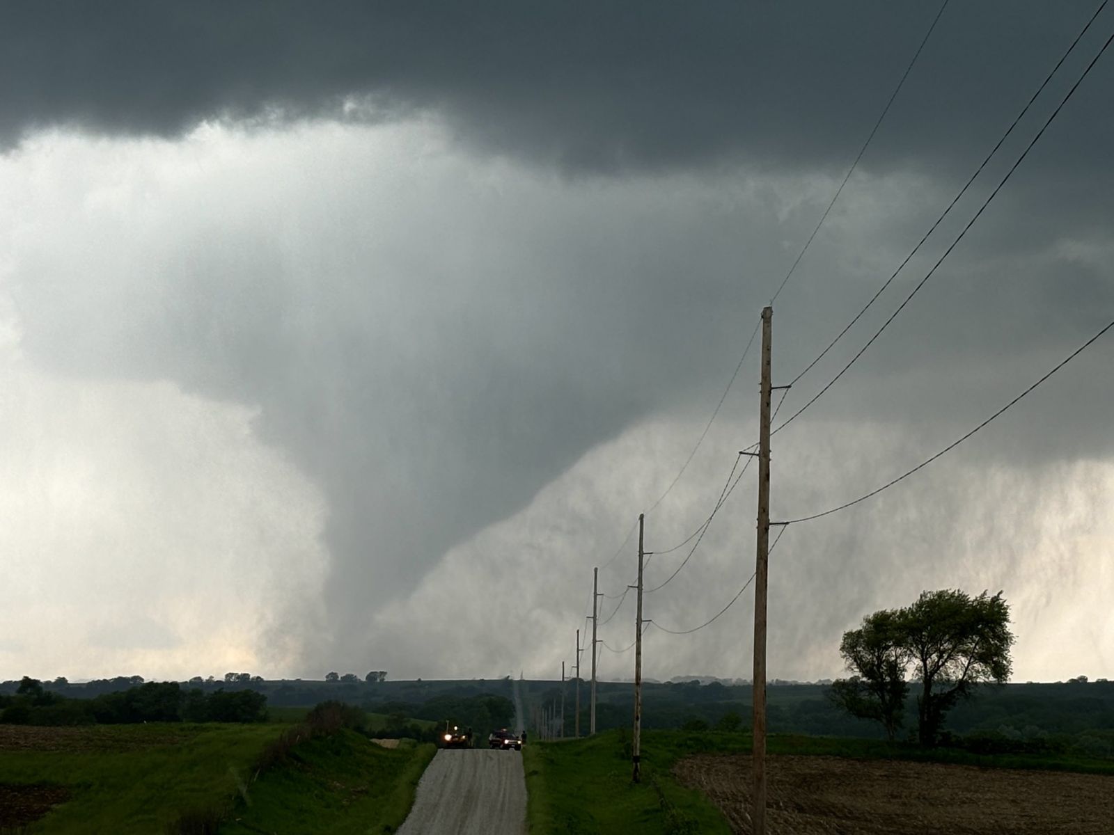
Multiple rounds of thunderstorms brought torrential rainfall, damaging winds, hail and destructive tornadoes to the state. These thunderstorms were the result of a low pressure system which lifted north into the area on the night of May 20th, 2024, producing slow moving storms that dropped 2 to 4 inches of rainfall. This resulted in flash flooding over portions of northern and central Iowa through the morning of May 21st, 2024. Following the heavy rainfall through the morning, skies cleared out ahead of an approaching cold front. By the afternoon hours of May 21st, 2024, this cold front produced a line of strong thunderstorms which produced multiple strong tornadoes throughout the state, including one which led to significant damage in the town of Greenfield, IA, among other locations. This line of storms also produced damaging winds, leading to widespread tree damage and power outages throughout the forecast area. Storm surveys have confirmed EF-4 damage in Greenfield, Iowa, EF-3 damage in NW Adams County, and EF-2 damage from two tornadoes: in Polk into Story County and near Arbor Hill. Other tornadoes from the event are also detailed below. We appreciate the assistance of emergency managers in assessing the damage across all of central Iowa. Damage Assessment Toolkit Viewer Information from surrounding offices: NWS Quad Cities | NWS Omaha Page last updated: June 3, 2024 6:05 AM |
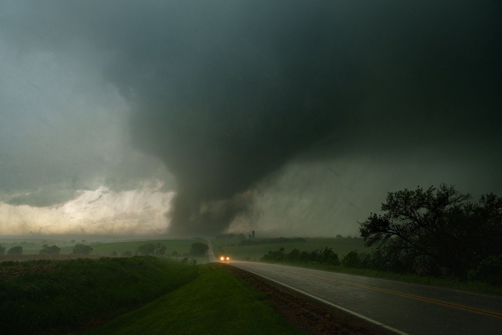
Photo Credit: Isaac Polanski |
 |
 |
 |
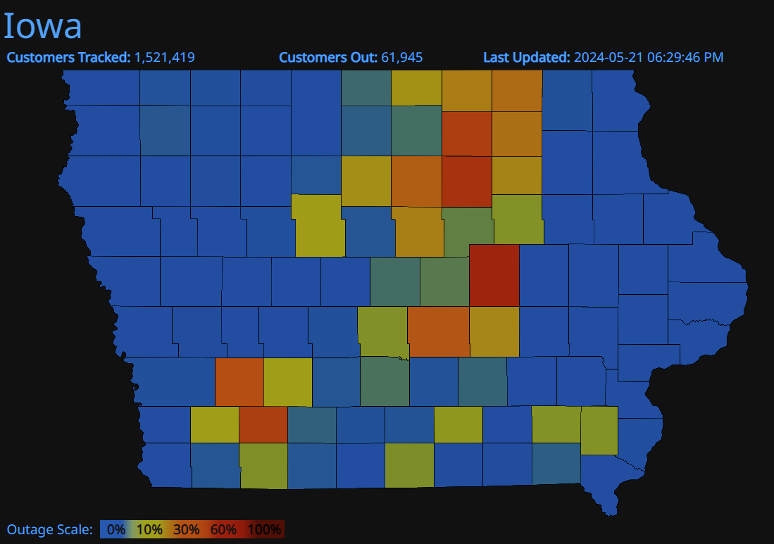
| Power Outages In Iowa as of 630 pm on 5-21-24 Graphic from PowerOutage.us |
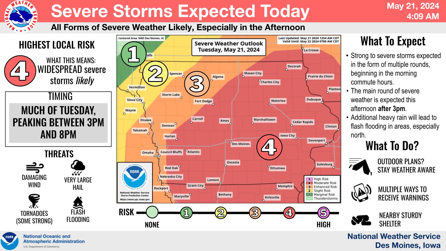
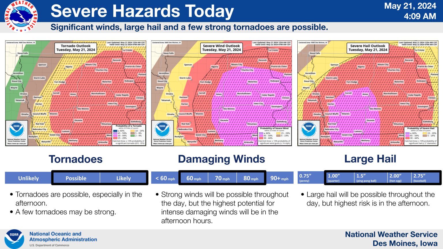
Moderate Risk (Level 4 out of 5) on 5-21-24 | Expected Hazards for 5-21-24 |
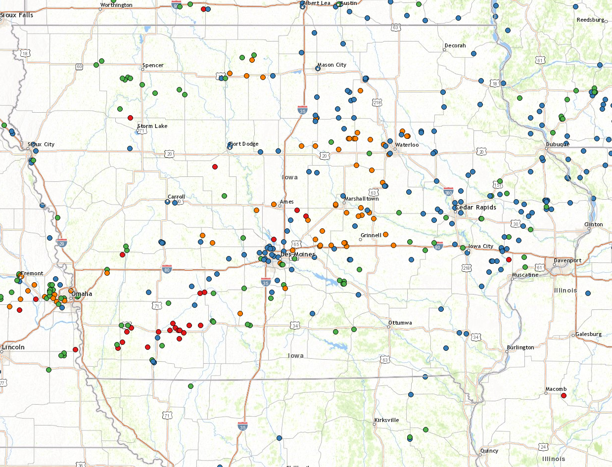
Tornadoes
|
Tornado #1 - Greenfield Tornado
|
||||||||||||||||
|
Tornado #2 - NW Adams County
|
||||||||||||||||
|
Tornado #3 - Polk/Story Tornado
|
||||||||||||||||
|
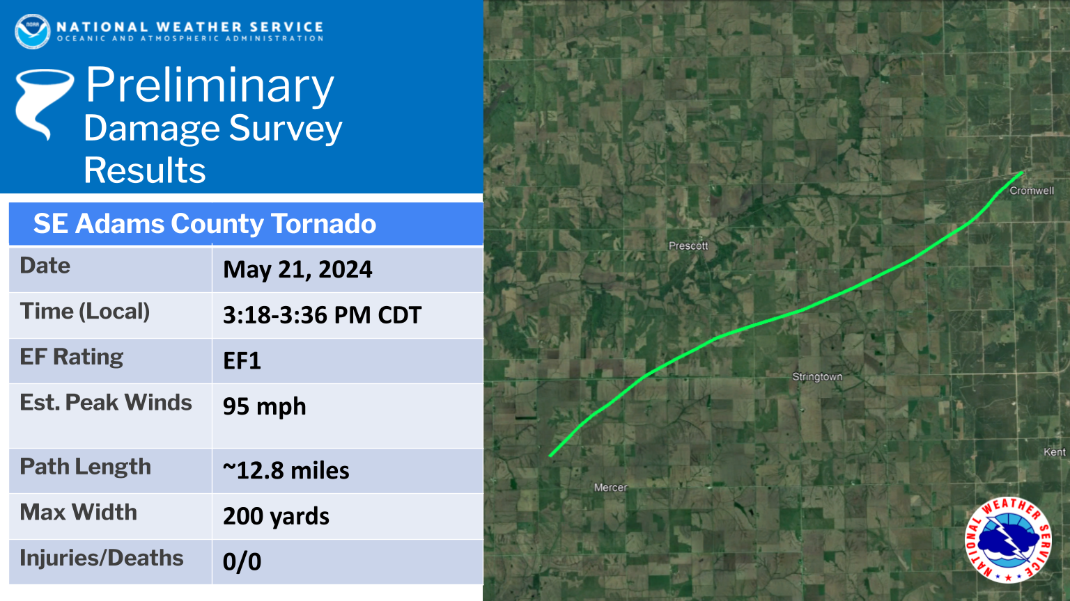
Tornado #4 - SE Adams Tornado
|
||||||||||||||||
|
Tornado #5 - Exira Tornado
Track Map 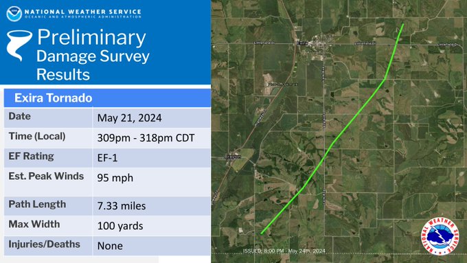 
Downloadable KMZ File |
||||||||||||||||
|
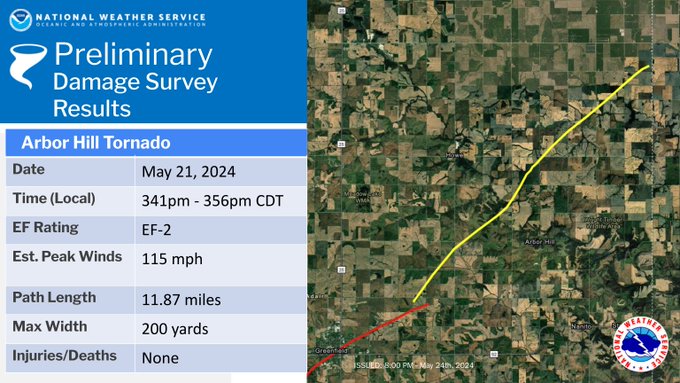
Tornado #6 - Arbor Hill Tornado
|
||||||||||||||||
|
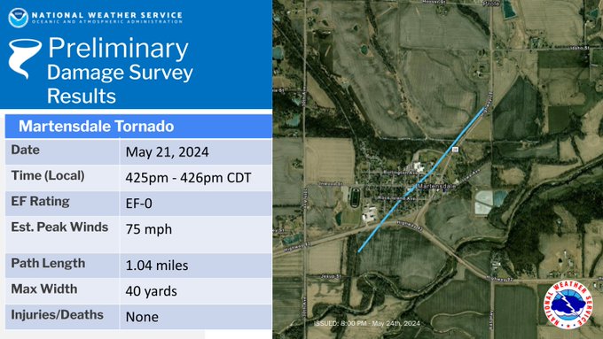
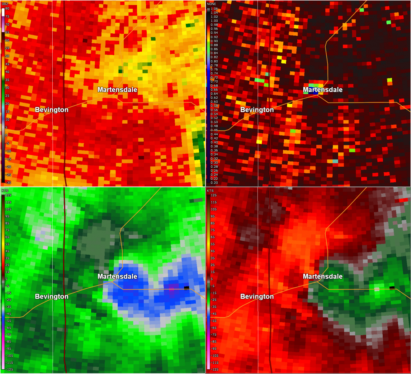
Tornado - #7 - Martensdale Tornado
|
||||||||||||||||
|
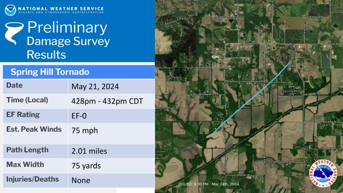
Tornado #8 - Spring Hill Tornado
|
||||||||||||||||
|
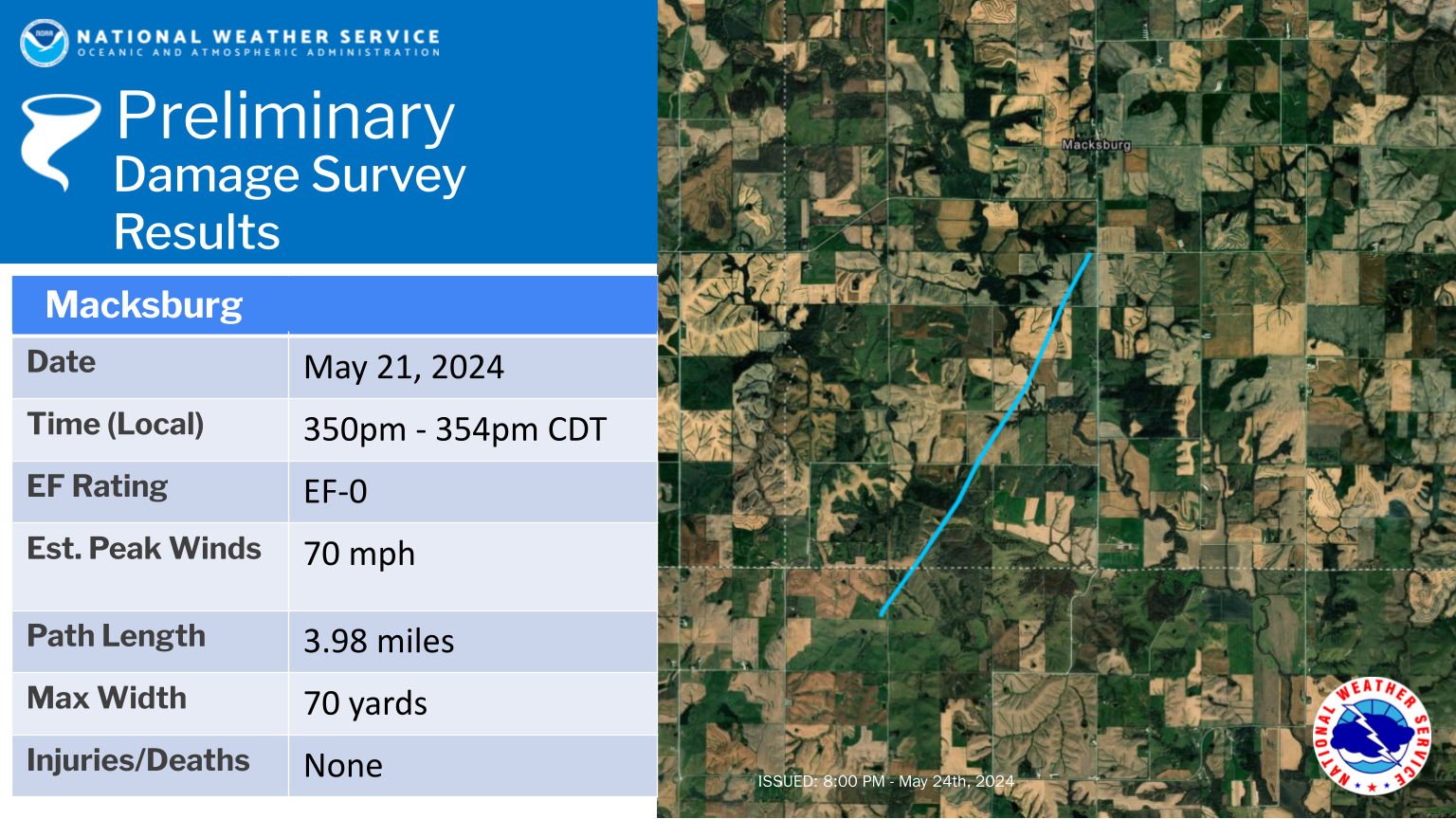
Tornado #9 - Macksburg
|
||||||||||||||||
|
Tornado - LOCATION
Track Map
Downloadable KMZ File |
||||||||||||||||
The Enhanced Fujita (EF) Scale classifies tornadoes into the following categories:
| EF0 Weak 65-85 mph |
EF1 Moderate 86-110 mph |
EF2 Significant 111-135 mph |
EF3 Severe 136-165 mph |
EF4 Extreme 166-200 mph |
EF5 Catastrophic 200+ mph |
 |
|||||
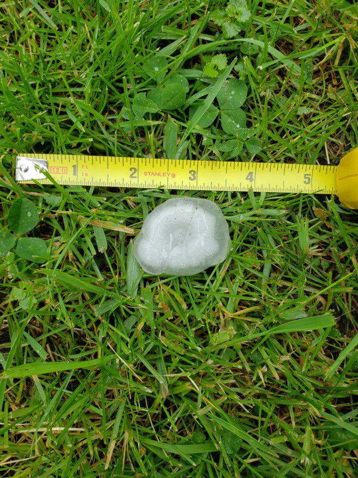
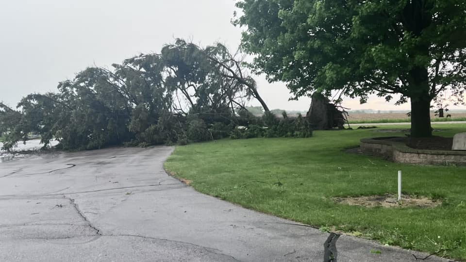
Hail & Wind Damage:
 |
 |
|
1.5 inch hail in Creston between 430 and 440pm. Photo credit: Brad Fogle |
Large tree down from strong winds in Hanlontown around 5:50 pm. Photo credit: Lisa Schaefer |
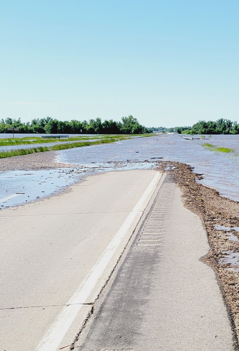
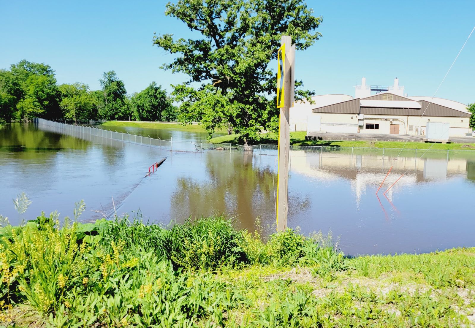
Flooding
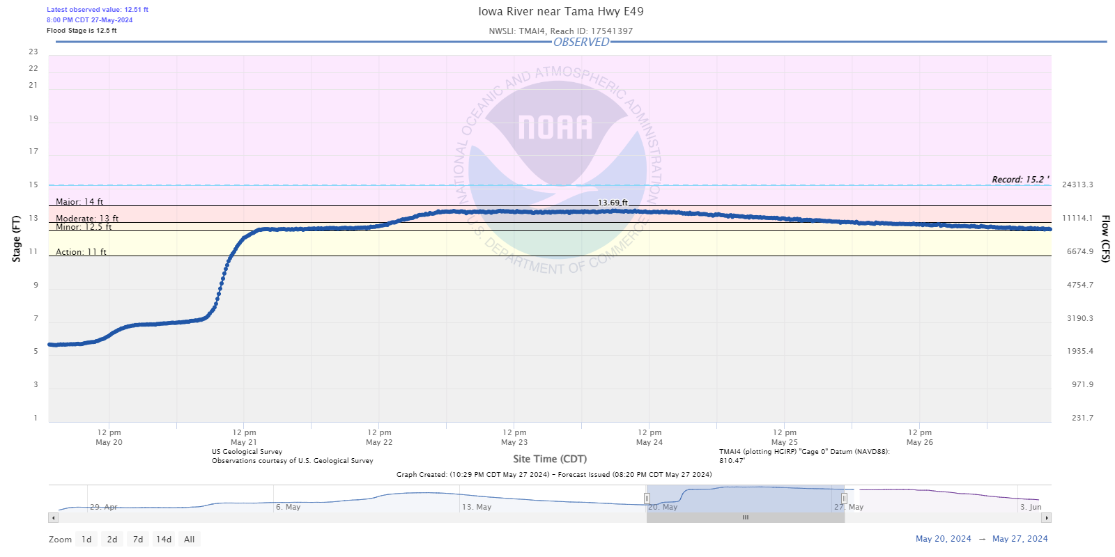
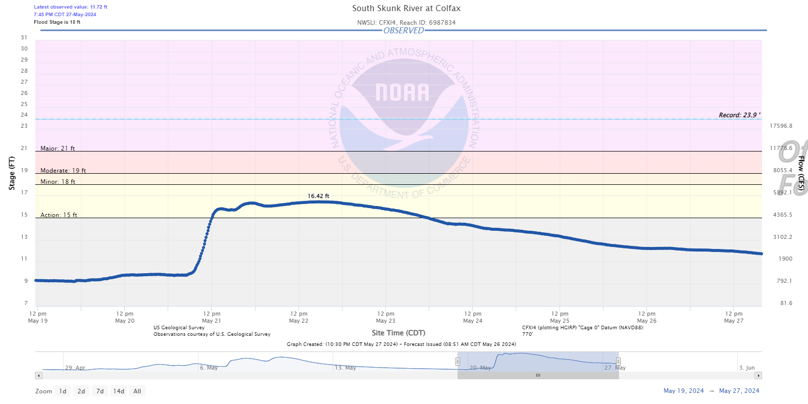
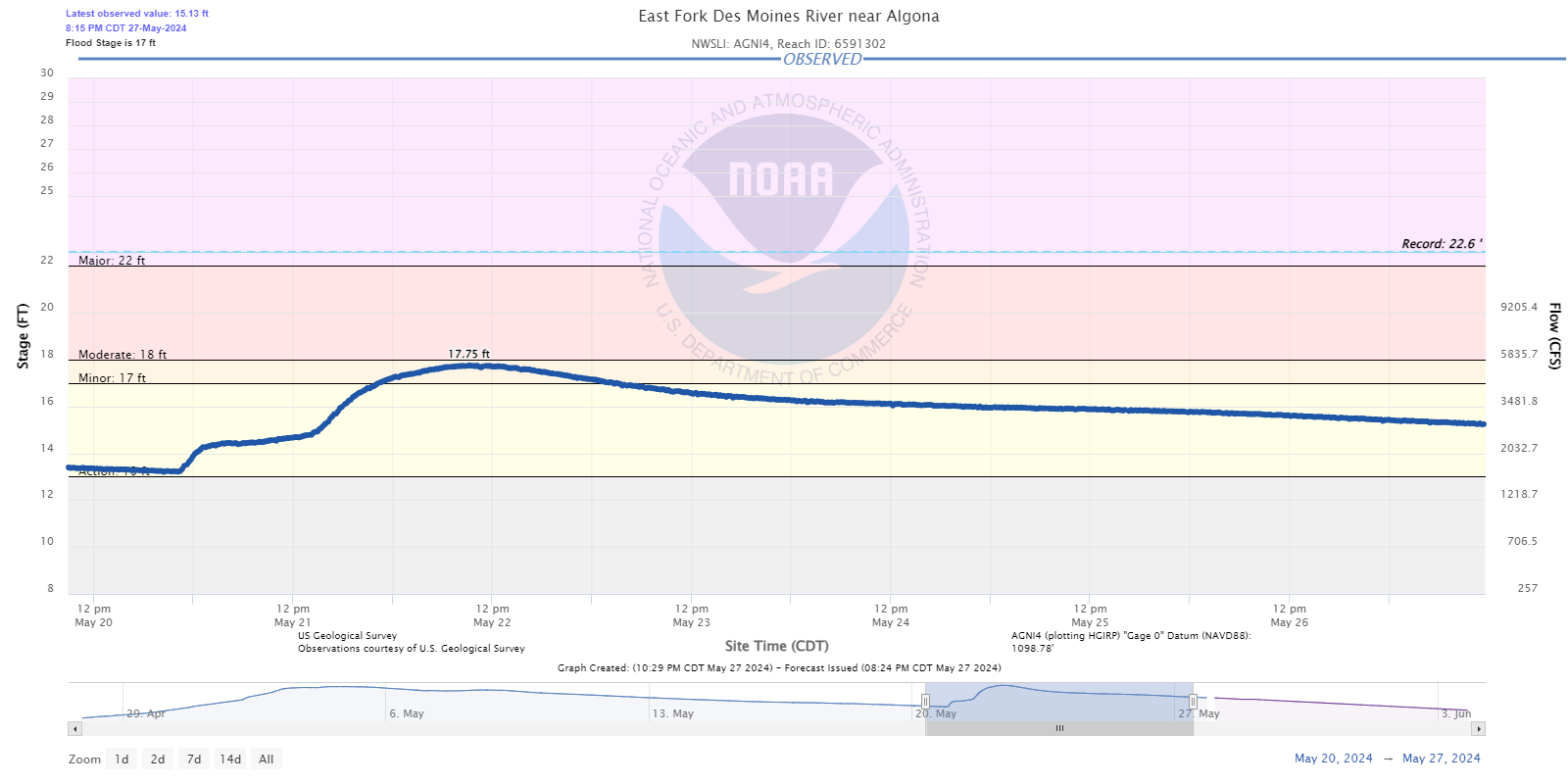
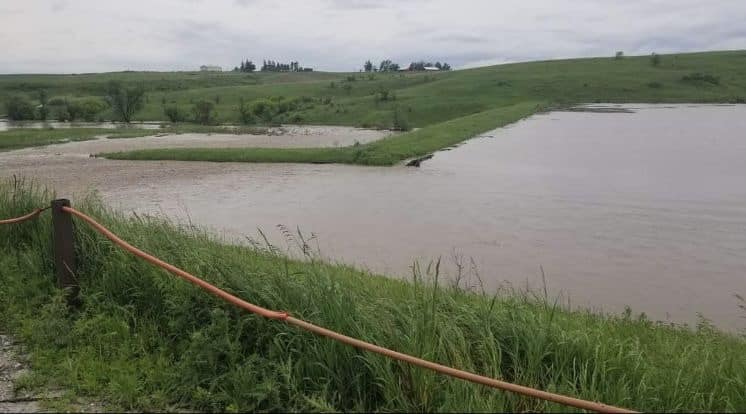
Significant flash flooding occurred across portions of central Iowa on the morning of May 21, 2024 impacting several communities including Kellogg and Baxter. Flash flooding threatened the water treatment and drinking water supply in Kellogg with sandbagging taking place. Numerous homes and other buildings were also flooded in town with evacuations. Sandbagging also took place in Baxter due to flooding, which threatened homes and other buildings. Some evacuations also took place. Car water rescues due to flash flooding were reported by the Meskwaki Nation Police Department with landslides reported in Marshall County affecting some roads. All told across central Iowa, there were approximately 75-100 road closures from local, county, state and federal roads with some road washouts, mainly on gravel, due to the swiftly moving flood waters.
Hydrographs
 |
 |
 |
 |
| Iowa River near Tama | South Skunk River at Colfax | East Fork Des Moines River at Algona | Cedar River at Cedar Falls |
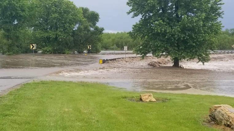
Photos and Rainfall Reports
 |
 |
 |
 |
| Near Rock Creek State Park, May 21, 2024 around 830am Photo: Emma Fox |
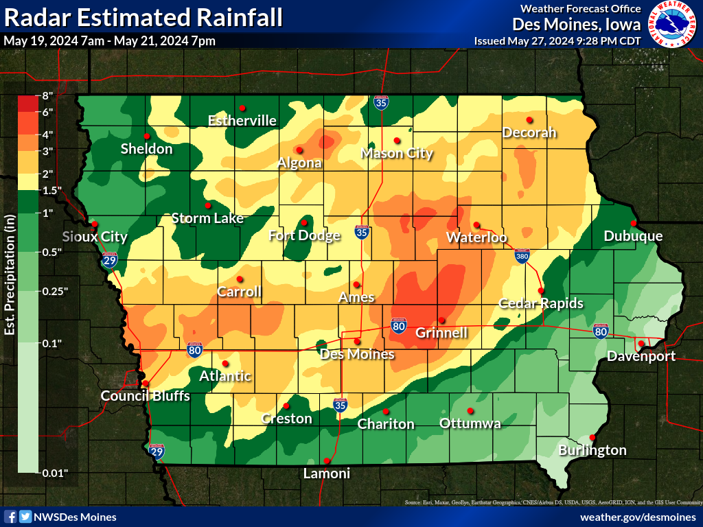
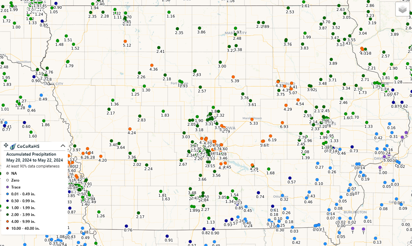
Radar estimated rainfall showing totals of 4-6 inches over Jasper and parts of Marshall, Tama, Poweshiek, Hardin, Grundy, and Black Hawk counties from May 19, 2024 at 7am until May 21, 2024 at 7pm. | CoCoRaHS rainfall reports May 20-22, 2024. Interactive Map |
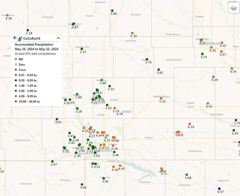
Zoomed in CoCoRaHS rainfall reports over portions of central Iowa May 20-22, 2024 Interactive Map |
 |
 |
 |
|
| Near Rock Creek State Park, May 21, 2024 around 830am Photo: Emma Fox |
Water over Highway 14 north of Marshalltown. Photo: Joe Price | Flood water at the Marshalltown Water Works. Photo: Joe Price |
Rain Reports
Rainfall reports prior to the arrival of the afternoon storms on May 21st, 2024.

Public Information Statement
National Weather Service Des Moines IA
125 PM CDT Tue May 21 2024

...PRECIPITATION REPORTS...

Location                     Amount    Time/Date
Algona                       5.08 in   0700 AM 05/21
Parkersburg                  4.74 in   0108 PM 05/21
Algona                       4.14 in   0115 PM 05/21
Pocahontas 0.5 W             4.02 in   0808 AM 05/21
Algona                       3.81 in   0119 PM 05/21
Algona 2.5 S                 3.60 in   0700 AM 05/21
Pocahontas                   3.41 in   0800 AM 05/21
3 N Toledo                   3.33 in   0700 AM 05/21
Audubon                      3.30 in   0800 AM 05/21
Ankeny                       3.27 in   0109 PM 05/21
Manning 0.2 ESE              3.18 in   0700 AM 05/21
Guthrie Center               3.12 in   0700 AM 05/21
Traer                        3.09 in   0700 AM 05/21
Garwin                       3.05 in   0600 AM 05/21
Britt 8.2 NNW                2.98 in   0700 AM 05/21
Nevada 4.6 S                 2.95 in   0700 AM 05/21
Pocahontas                   2.90 in   0110 PM 05/21
Maxwell 2.5 N                2.90 in   0700 AM 05/21
Vining 0.2 ENE               2.90 in   0700 AM 05/21
Iowa Falls                   2.90 in   0700 AM 05/21
Liscomb                      2.88 in   0115 PM 05/21
Ankeny 2.3 NE                2.75 in   0700 AM 05/21
Iowa Falls Airport           2.72 in   0115 PM 05/21
Gilbertville 1.0 NW          2.68 in   0800 AM 05/21
Polk City 0.4 W              2.65 in   0700 AM 05/21
Audubon Airport              2.65 in   0115 PM 05/21
Waterloo Airport             2.65 in   1254 PM 05/21
Perry                        2.62 in   0115 PM 05/21
4 SSW Waterloo               2.62 in   0115 PM 05/21
Polk City 0.8 W              2.61 in   0700 AM 05/21
Malcom 7.7 NNW               2.61 in   0700 AM 05/21
0.7 SW Tama                  2.59 in   0100 PM 05/21
Madrid                       2.57 in   0106 PM 05/21
0.7 NW Toledo                2.53 in   0100 PM 05/21
Grinnell 0.6 NW              2.50 in   1100 AM 05/21
Johnston 3.7 NNW             2.44 in   0700 AM 05/21
Bondurant 1.0 NE             2.40 in   0627 AM 05/21
3 NNW Pleasant Hill          2.37 in   1259 PM 05/21
Ankeny 1.5 NNE               2.35 in   0700 AM 05/21
Polk City 1.0 N              2.34 in   0700 AM 05/21
Ankeny 2.4 NW                2.28 in   0700 AM 05/21
Big Creek Ponding            2.25 in   1215 PM 05/21
Ankeny 3.3 ESE               2.24 in   0700 AM 05/21
NEAL SMITH NWR DES MOINES 17 2.24 in   0110 PM 05/21
New Providence               2.22 in   0100 PM 05/21
Mallard                      2.20 in   0100 PM 05/21
Iowa Falls 4.6 NNE           2.20 in   0646 AM 05/21
Perry Airport                2.20 in   1255 PM 05/21
Beaman                       2.18 in   0109 PM 05/21
1 NE Johnston                2.16 in   0116 PM 05/21
Hudson 1.1 SSE               2.15 in   0700 AM 05/21
Marshalltown                 2.07 in   0120 PM 05/21
Jefferson 0.1 ENE            2.05 in   0900 AM 05/21
Fonda 4.5 NNW                2.04 in   0800 AM 05/21
Marshalltown 0.2 WSW         2.03 in   0803 AM 05/21
Eldora                       2.01 in   0100 PM 05/21

Observations are collected from a variety of sources with varying
equipment and exposures. We thank all volunteer weather observers
for their dedication. Not all data listed are considered official.
Photos & Video
 |
 |
 |
 |
| South of Greenfield. (Photo Credit: Adam Orgler) |
Carbon to Morton Mills tornado (Photo Credit: David Baxter) |
Corning tornado (Photo Credit: Colt Forney) |
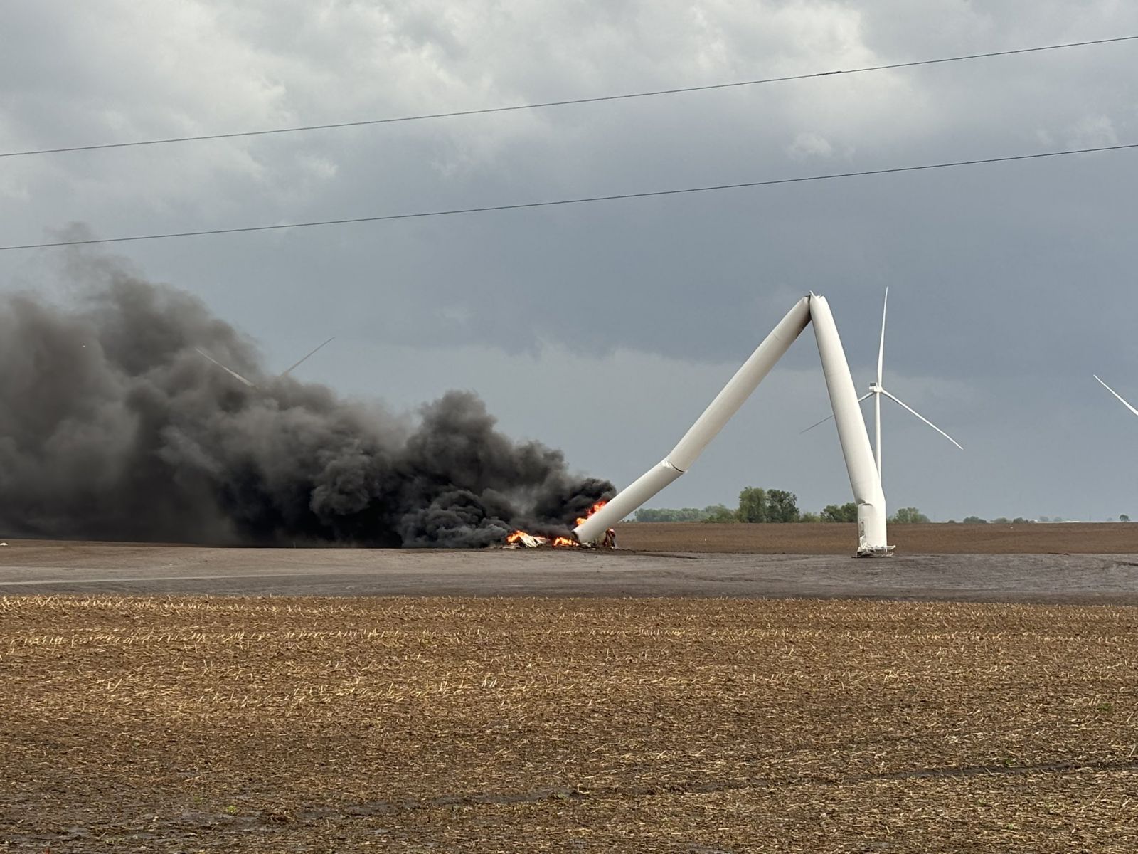
Wind turbine destroyed by tornado (Photo Credit: Colt Forney) |
Header
| Caption (source) |
Caption (source) |
Caption (source) |
Caption (source) |
Radar & Satellite
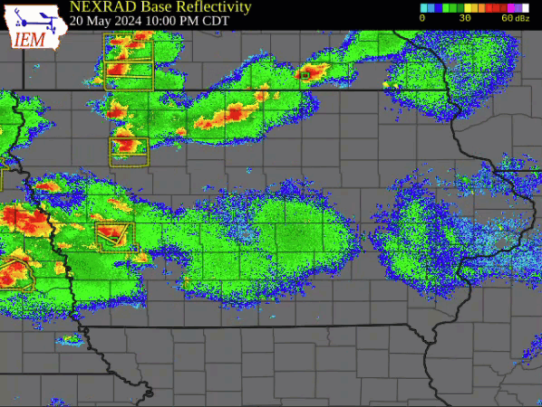
Full radar loop with warnings courtesy of the Iowa Environmental Mesonet.
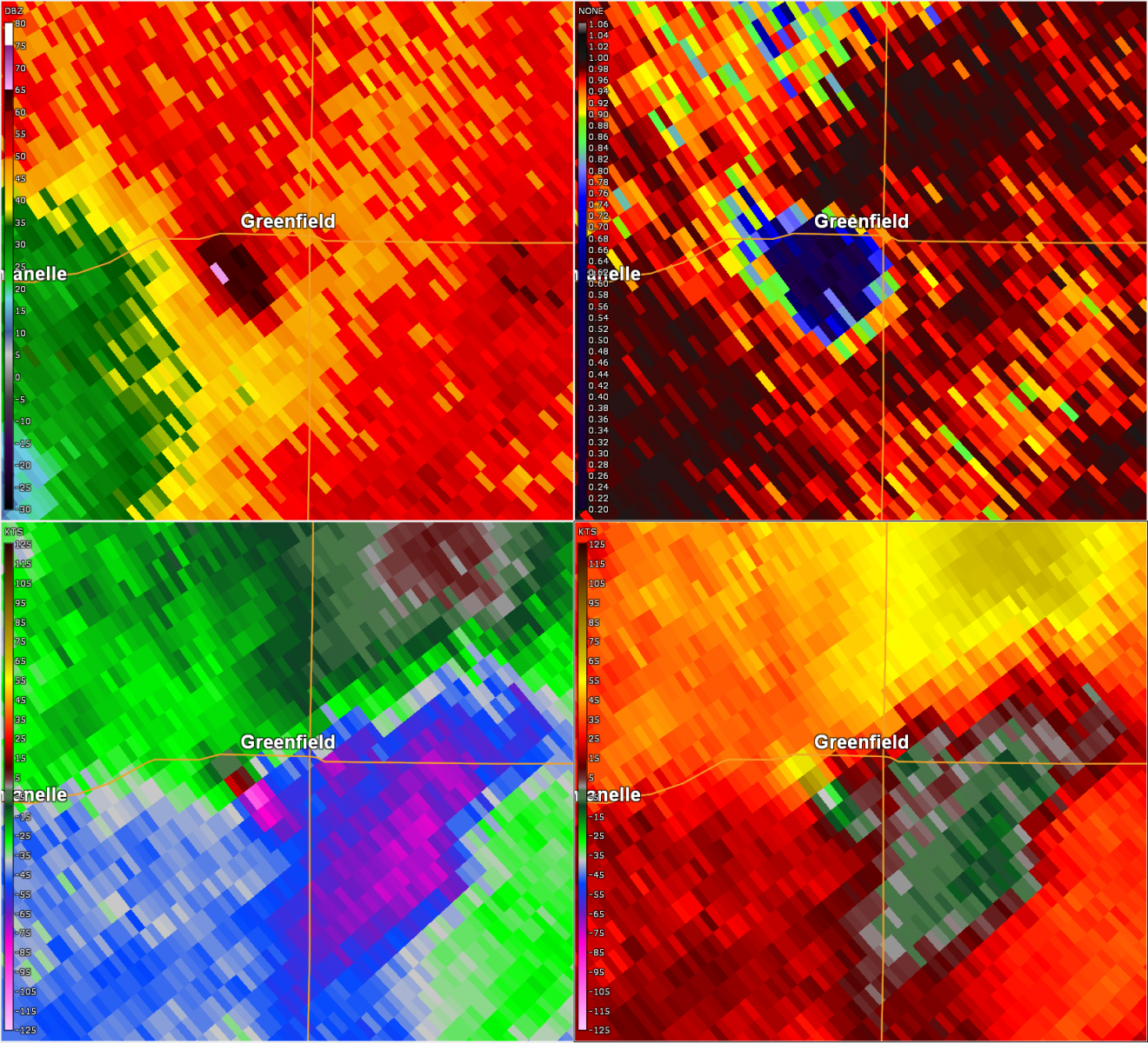
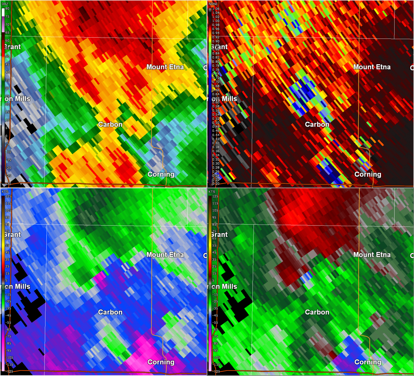
Des Moines Radar Images
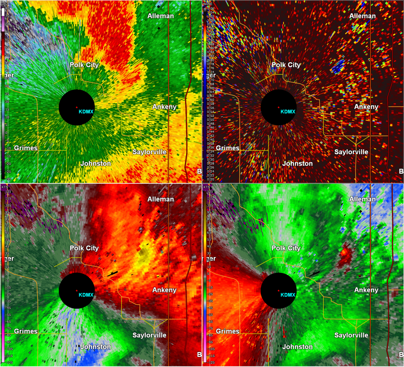
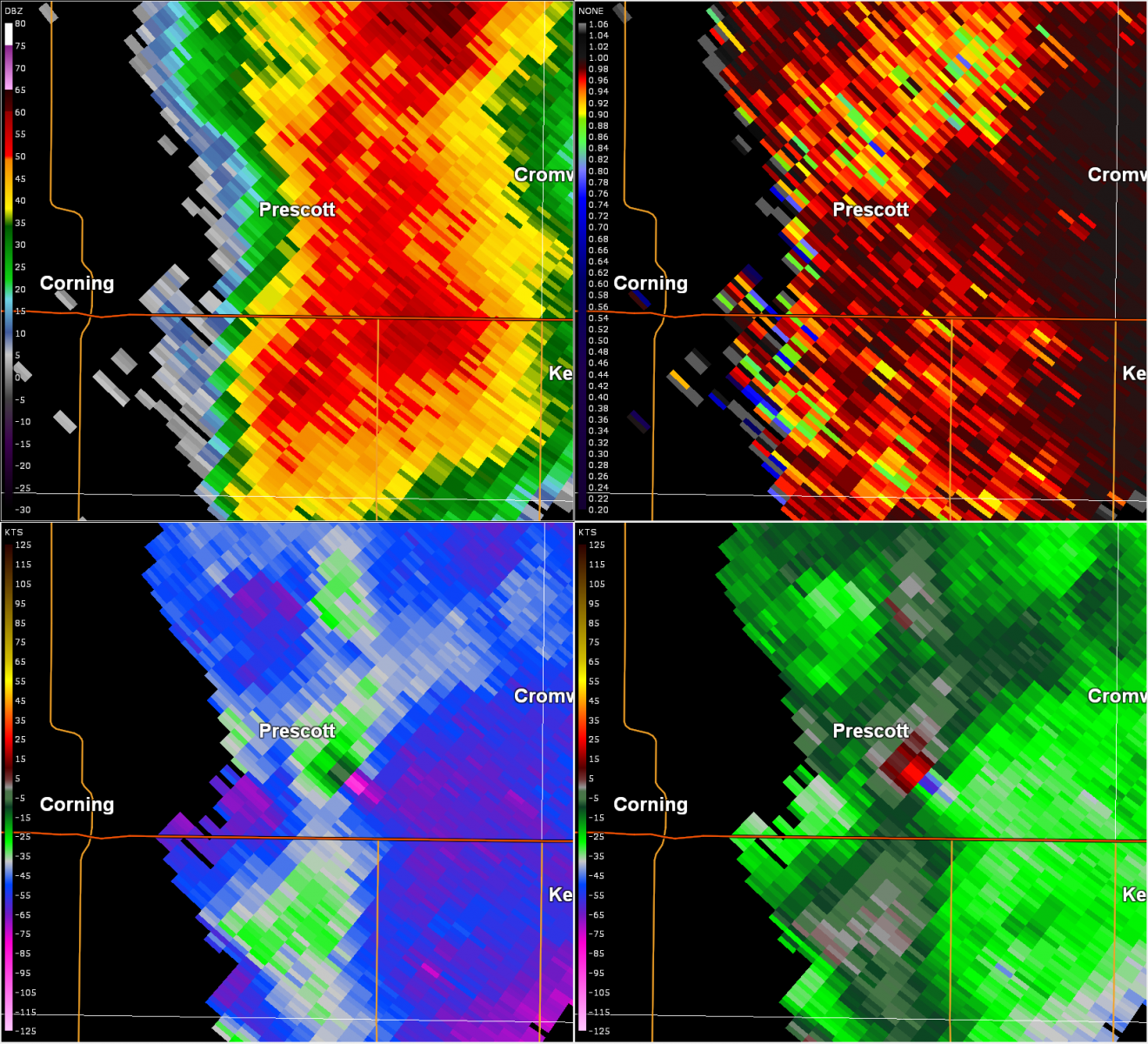
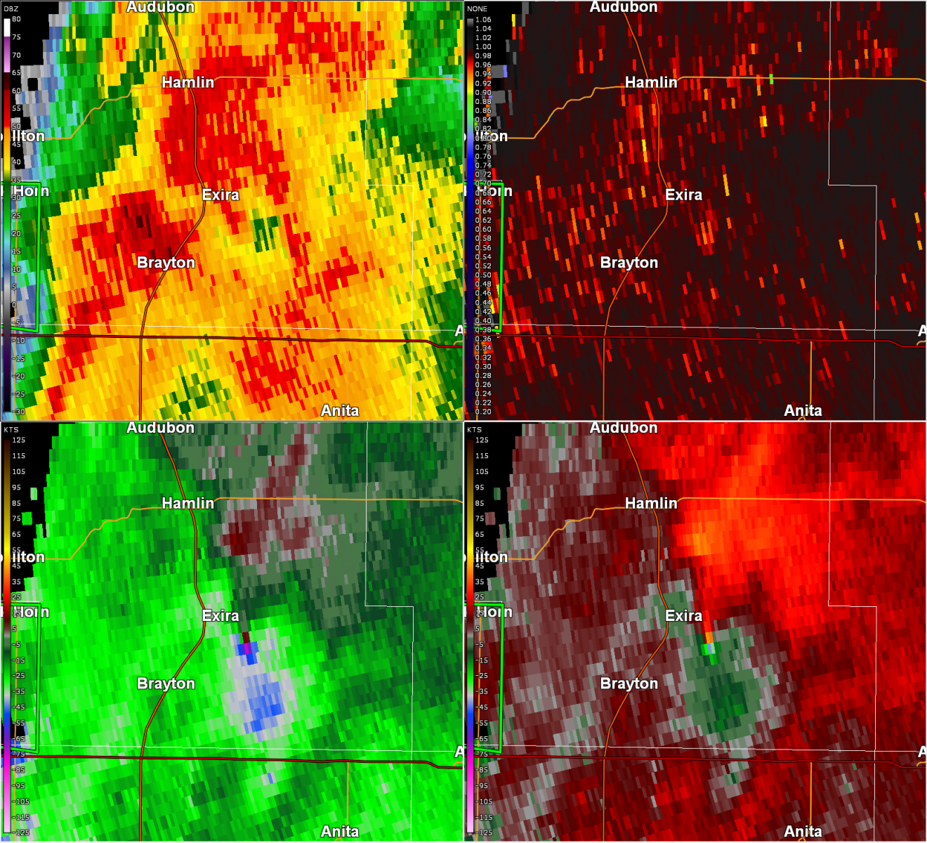
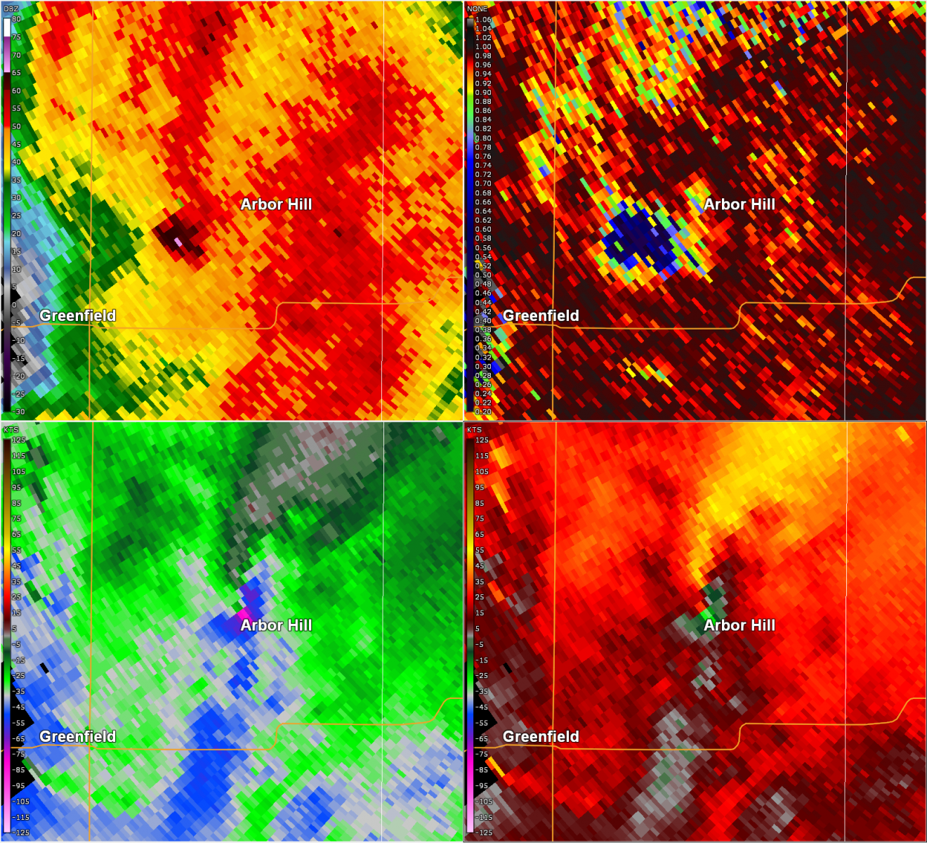
Each image below shows the 0.5 degree tilt (unless otherwise noted) of reflectivity (top left), correlation coefficient (top right), base velocity (bottom left), and storm relative velocity (bottom right). In the velocity images, where a warm color meets a cool color, such as red and green, this is the radar signature of rotation. Blue in the correlation coefficient is debris from the tornado, though not all images below show this feature.
 |
 |
 |
 |
| Radar as tornado nears Greenfield |
Radar of tornado near Carbon | Radar 0.9 degree tilt of tornado between Polk City and Ankeny as it tracks northeast | Radar as tornado tracks near Prescott |
 |
 |
 |
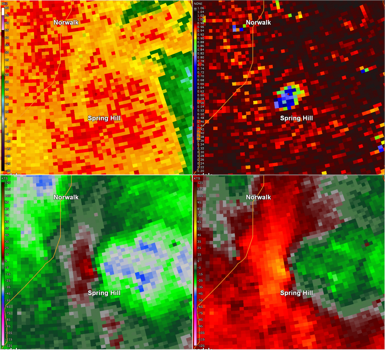 |
| Radar of tornado near Exira | Radar as tornado passes close to Arbor Hill | Radar as tornado moves through Martensdale | Radar as tornado passes Spring Hill |
Blog Posts
Tornado Damage in Greenfield - NASA Earth Observatory
Environment
 |
 |
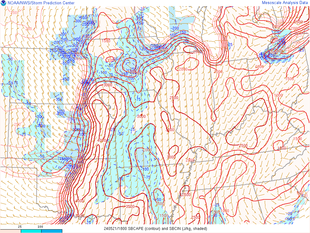 |
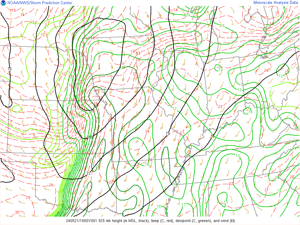
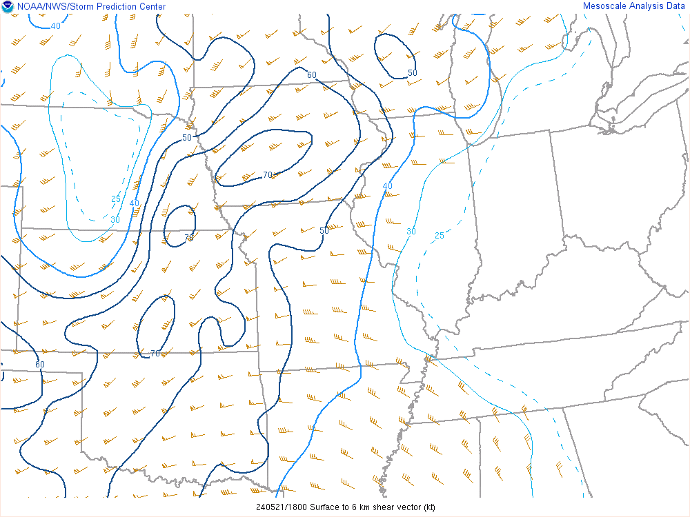
| Figure 1: 925 mb map loop from 1pm (18z) to 7pm (00z) May 21st. | Figure 2: 0-6 km shear map loop from 1pm (18z) to 7pm (00z) May 21st. | Figure 3: Surface-based CAPE map loop from 1pm (18z) to 7pm (00z) May 21st. |
 |
 |
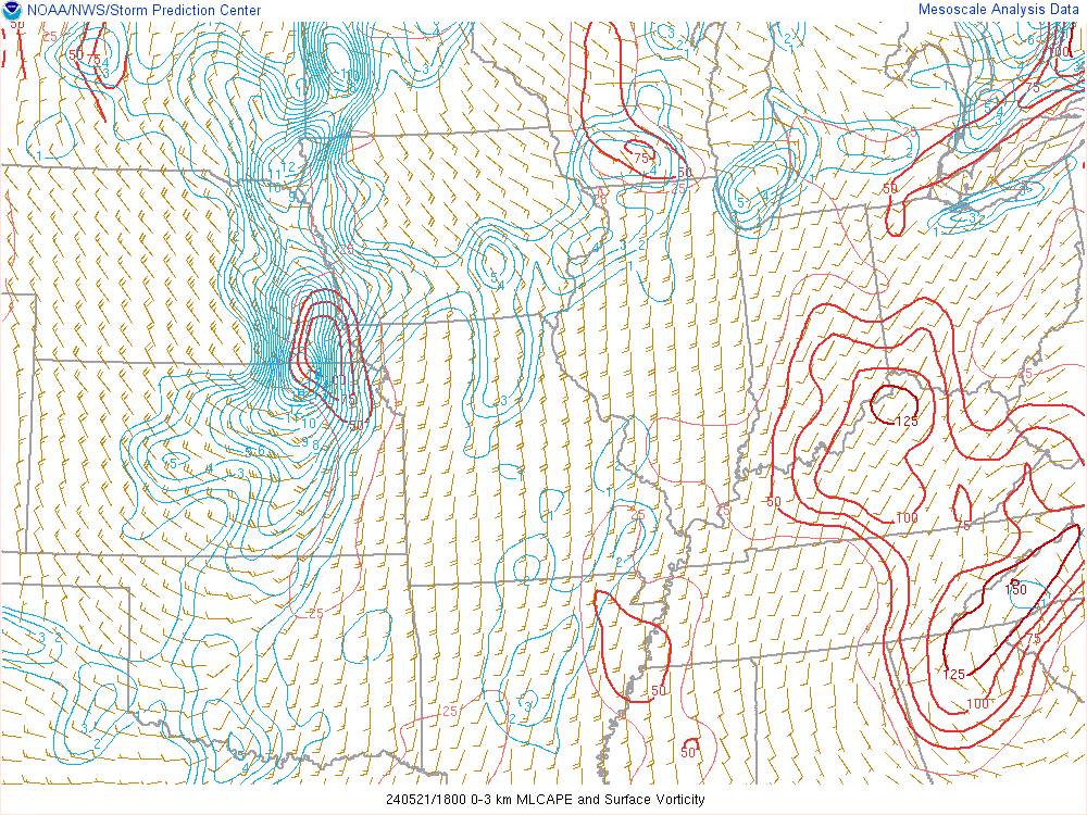 |
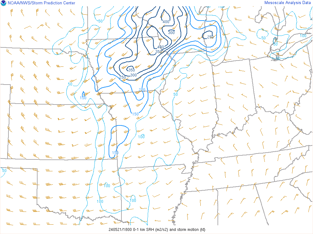
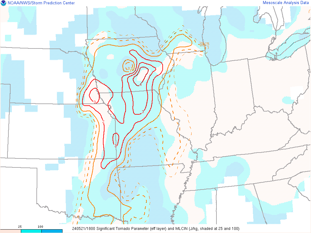
| Figure 4: 0-1 km storm relative helicity map loop from 1pm (18z) to 7pm (00z) May 21st. | Figure 5: Significant Tornado Parameter (STP) map loop from 1pm (18z) to 7pm (00z) May 21st. | Figure 6: 0-3 km MLCAPE and surface vorticity map loop from 1pm (18z) to 7pm (00z) May 21st. |
 |
Media use of NWS Web News Stories is encouraged! Please acknowledge the NWS as the source of any news information accessed from this site. |
|