Numerous severe thunderstorms are expected across a broad region from the Ohio Valley to the Mid-Atlantic and Northeast States today into tonight. Swaths of damaging wind gusts are expected and some tornadoes are possible. Bertha is expected to bring tropical storm conditions to portions of the Gulf Coast from the Florida Panhandle westward to southeastern Louisiana later today and Wednesday. Read More >
Overview
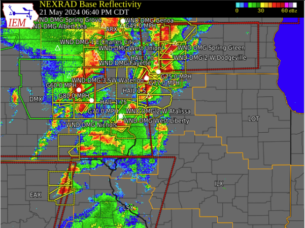
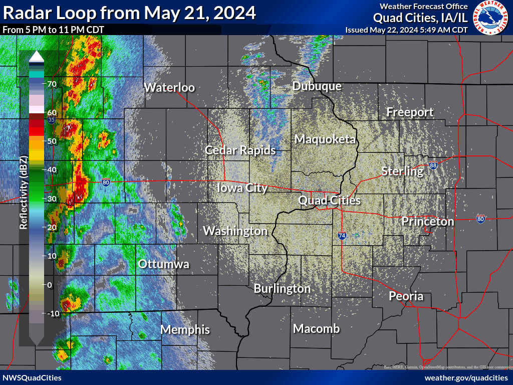
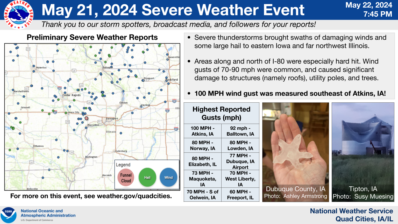
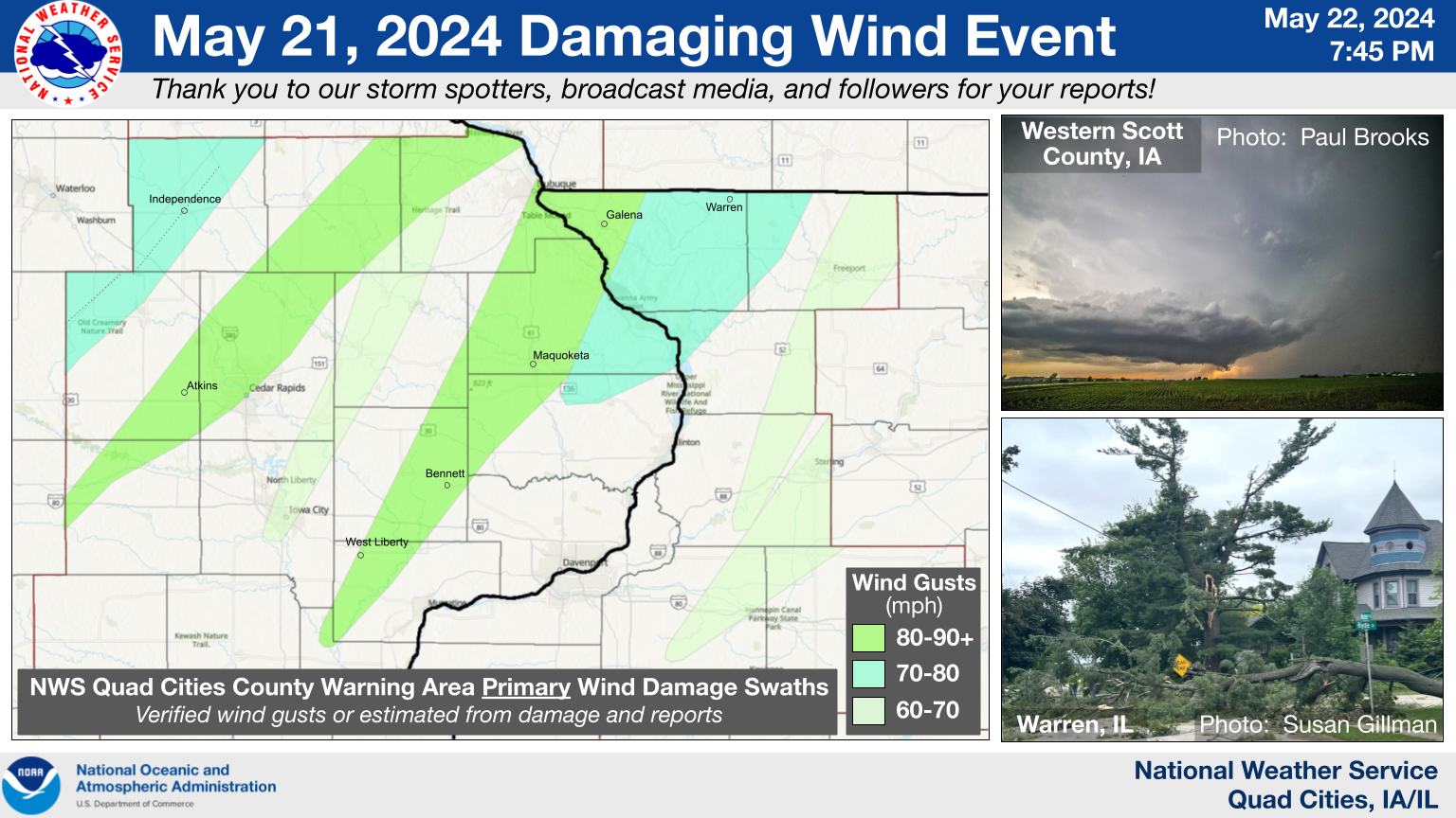
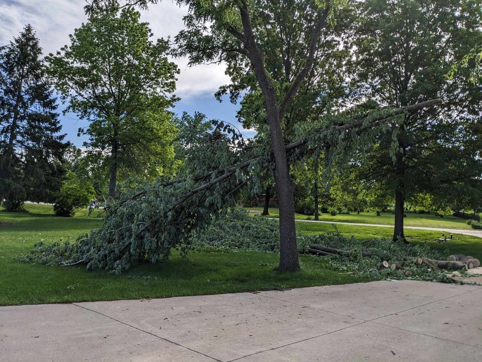
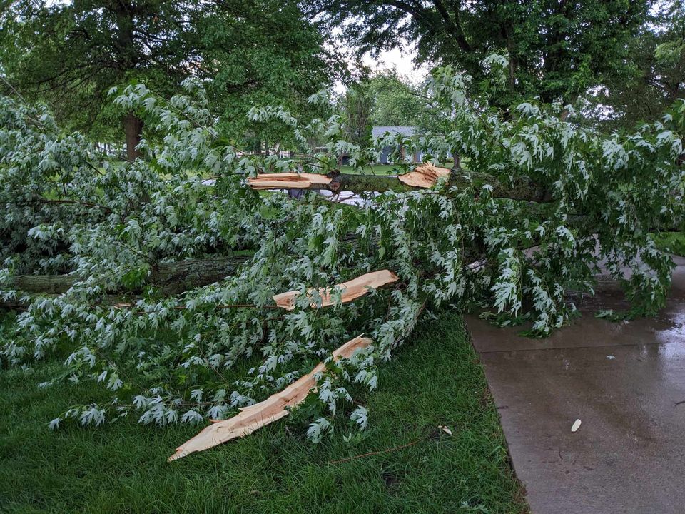
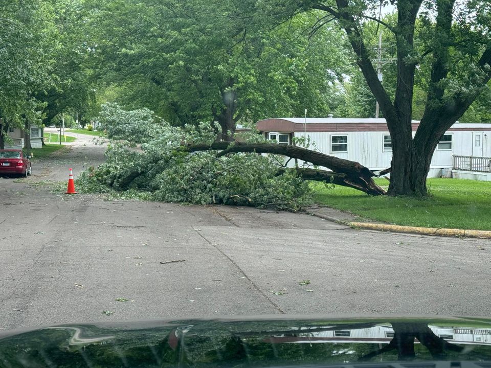
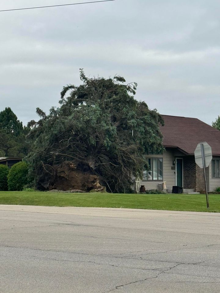
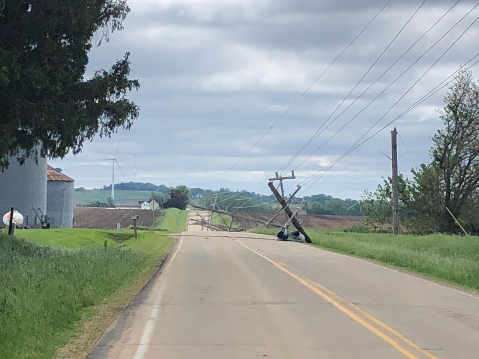
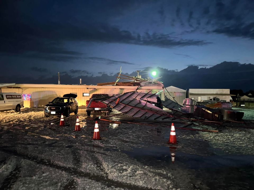
Numerous severe thunderstorms moved through the area on Tuesday, May 21. The bulk of the severe weather occurred during the late afternoon and evening time frame, with several Severe Thunderstorm Warnings issued over eastern Iowa into northwestern Illinois.
Straight-line winds were the main hazard with the storms and impressive wind gusts were observed. The strongest gust reported was 100 mph, which was from a personal weather station located just southeast of Atkins, IA! There were also several other locations that reported wind gusts in excess of 70 mph, and damage consistent with that.
 |
 |
Other NWS Event Summaries: Western Iowa | Central Iowa (including Greenfield EF4 Tornado) | Northeast Iowa
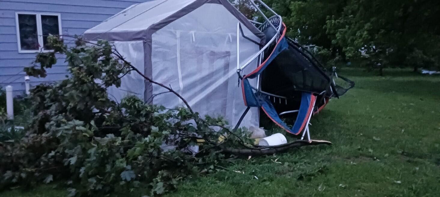
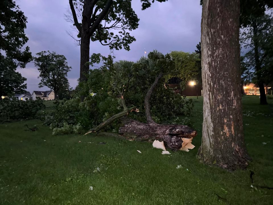
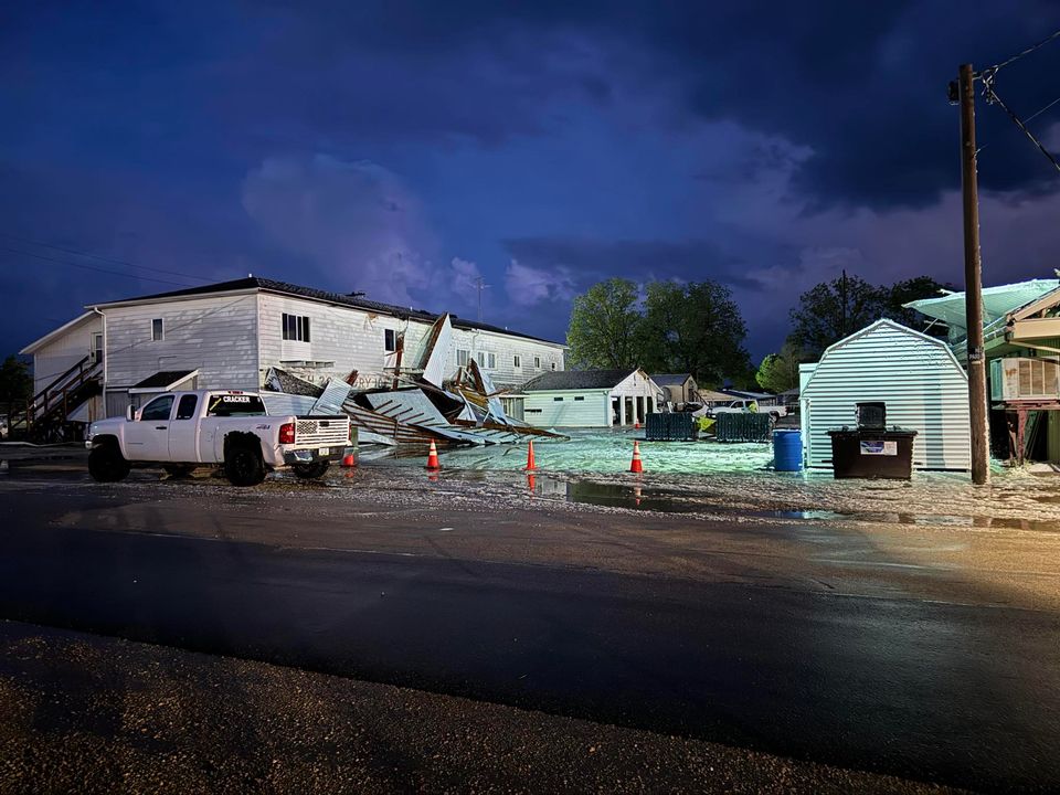
Photos & Video
 |
 |
 |
| Image Courtesy of Daria Shelley Hosford Kamp (Marion IA) | Image Courtesy of Daria Shelley Hosford Kamp (Marion IA) | Image Courtesy of James Monroe (Freeport IL) |
 |
 |
 |
| Image Courtesy of James Monroe (Freeport IL) | Image Courtesy of Joe Sidor (Warren/Nora IL) | Image Courtesy of Joe Sidor (Warren/Nora IL) |
 |
 |
 |
| Image Courtesy of Nathan Heaverlo (Maquoketa IA) | Image Courtesy of Nathan Heaverlo (Maquoketa IA) | Image Courtesy of Nathan Heaverlo (Maquoketa IA) |
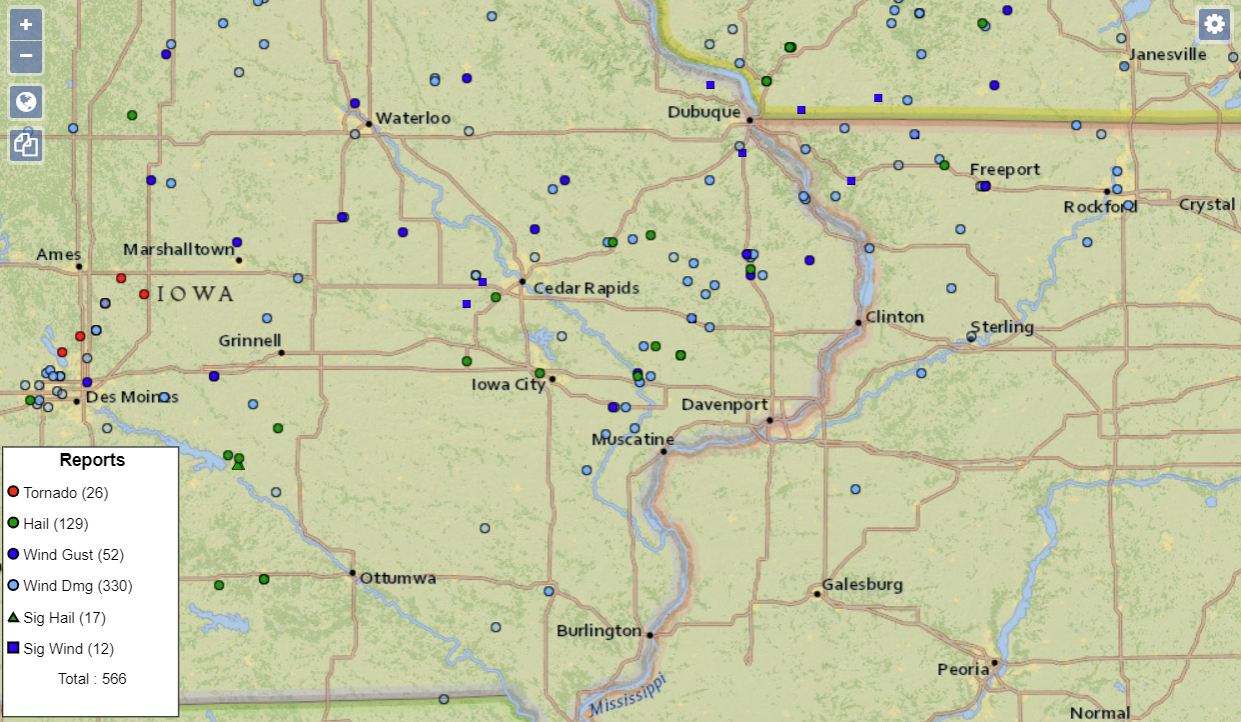
Storm Reports
|
Storm Report Map of County Warning Area and Adjacent Areas Note numbers of reports on key are nationwide totals from May 21 |
 |
| Interactive Storm Report Map (SPC) |
| Nationwide Storm Report Map Image (SPC) |
Preliminary Local Storm Report...Summary
National Weather Service Quad Cities IA IL
800 PM CDT Wed May 22 2024
..TIME... ...EVENT... ...CITY LOCATION... ...LAT.LON...
..DATE... ....MAG.... ..COUNTY LOCATION..ST.. ...SOURCE....
..REMARKS..
0645 AM Tstm Wnd Dmg 2 WSW Independence 42.46N 91.92W
05/21/2024 Buchanan IA Trained Spotter
Large tree down, with time estimated by
radar.
0710 AM Rain Belle Plaine 41.90N 92.28W
05/21/2024 M1.50 Inch Benton IA Trained Spotter
Intense rainfall that fell mainly from 630
AM up to just before the time of report.
1041 AM Rain Jesup 42.47N 92.07W
05/21/2024 M2.10 Inch Buchanan IA Trained Spotter
Rain measured by electronic device.
1203 PM Rain 2 ENE Hazleton 42.63N 91.86W
05/21/2024 M2.31 Inch Buchanan IA CO-OP Observer
Rainfall so far since midnight.
1232 PM Hail 2 WNW Genoa Bluff 41.73N 92.18W
05/21/2024 M0.70 Inch Iowa IA Trained Spotter
1241 PM Hail Williamsburg 41.66N 92.01W
05/21/2024 M0.25 Inch Iowa IA Public
1243 PM Hail 4 SW Homestead 41.72N 91.91W
05/21/2024 M1.00 Inch Iowa IA Public
Report from mPING: Quarter (1.00 in.).
0115 PM Hail Lisbon 41.92N 91.38W
05/21/2024 M0.50 Inch Linn IA Emergency Mngr
0345 PM Non-Tstm Wnd Dmg Mccausland 41.74N 90.44W
05/21/2024 Scott IA Public
via facebook. photo of a broken tree limb
from non thunderstorm winds. time estimated.
0530 PM Tstm Wnd Dmg 1 SSW Memphis 40.45N 92.17W
05/21/2024 Scotland MO Law Enforcement
Strong winds reported in Memphis leading to
power outages.
0553 PM Hail 1 ENE Anamosa 42.11N 91.27W
05/21/2024 M1.00 Inch Jones IA Trained Spotter
1 inch hail report by spotter.
0559 PM Tstm Wnd Dmg 3 ESE Stockport 40.84N 91.78W
05/21/2024 Van Buren IA Trained Spotter
4 inch diameter tree branch down. Time
estimated from radar.
0602 PM Hail 1 NNW Center Junction 42.13N 91.10W
05/21/2024 M1.75 Inch Jones IA Trained Spotter
JO100 spotter ID called in Hail report..
sent picture to Facebook. Kurt Andreesen
Farmstead. 1 mile north Center Junction IA.
0608 PM Tstm Wnd Dmg Wyoming 42.06N 91.00W
05/21/2024 Jones IA Trained Spotter
Corrects time on previous tstm wnd dmg
report from Wyoming. tree limbs down. 3
inches in diameter. estimated 60 to 70 mph
gusts.
0609 PM Hail 1 NE Rochester 41.67N 91.16W
05/21/2024 M1.00 Inch Cedar IA Trained Spotter
0611 PM Tstm Wnd Dmg Mount Pleasant 40.96N 91.55W
05/21/2024 Henry IA Law Enforcement
Power pole broken and some branches down.
Time estimated from radar.
0611 PM Tstm Wnd Dmg 2 NNW Oakland Mills 40.97N 91.63W
05/21/2024 Henry IA Trained Spotter
delayed report. 3 to 5 inch diameter
branches down. time estimated.
0620 PM Tstm Wnd Dmg Fairbank 42.63N 92.05W
05/21/2024 Buchanan IA Emergency Mngr
Corrects previous reports. Roofs blown off
of multiple homes in Fairbank. Time
estimated by radar.
0623 PM Tstm Wnd Gst 2 S Oelwein 42.64N 91.91W
05/21/2024 E70 MPH Buchanan IA Emergency Mngr
.
0635 PM Tstm Wnd Dmg 2 SW Conesville 41.36N 91.38W
05/21/2024 Louisa IA Emergency Mngr
Shed destroyed.
0635 PM Tstm Wnd Dmg Brighton 41.17N 91.83W
05/21/2024 Washington IA Trained Spotter
Large tree limb blown down. Time estimated
from radar.
0636 PM Tstm Wnd Gst 2 W Garrison 42.14N 92.19W
05/21/2024 M60 MPH Benton IA Emergency Mngr
0638 PM Tstm Wnd Gst 1 E Dubuque Regional Ar 42.40N 90.70W
05/21/2024 M77 MPH Dubuque IA ASOS
ASOS station KDBQ Dubuque Arpt.
0639 PM Tstm Wnd Dmg 2 N Dubuque Regional Ar 42.42N 90.71W
05/21/2024 Dubuque IA Trained Spotter
tree blown over. estimated 75 mph.
0641 PM Hail 3 W Delmar 42.02N 90.66W
05/21/2024 M1.50 Inch Clinton IA Public
Report from mPING: Ping Pong Ball (1.50
in.).
0646 PM Hail 3 E Tipton 41.77N 91.08W
05/21/2024 M1.75 Inch Cedar IA Emergency Mngr
0651 PM Tstm Wnd Dmg 2 SSE Rochester 41.65N 91.15W
05/21/2024 Cedar IA Public
4 Semi trailers blown over around I-80 Exit
265. Time estimated from radar.
0652 PM Tstm Wnd Dmg West Liberty 41.57N 91.26W
05/21/2024 Muscatine IA Trained Spotter
Numerous trees and branches down across the
city. Straight-line winds.
0652 PM Tstm Wnd Gst 1 ENE Norway 41.91N 91.91W
05/21/2024 M80 MPH Benton IA Emergency Mngr
0652 PM Tstm Wnd Dmg 2 W Atalissa 41.57N 91.21W
05/21/2024 Muscatine IA Emergency Mngr
70 mph winds. Debris all over Highway 6
outside of Atalissa.
0652 PM Tstm Wnd Gst 1 W West Liberty 41.57N 91.27W
05/21/2024 M70 MPH Muscatine IA Emergency Mngr
0652 PM Tstm Wnd Dmg 1 WNW Independence 42.47N 91.90W
05/21/2024 Buchanan IA Trained Spotter
Widespread tree damage in northwest
Independence. Trees uprooted and blown over.
Some roof damage to sheds nearby. Leaning
power poles. Time estimated from radar.
0653 PM Tstm Wnd Dmg Nichols 41.48N 91.30W
05/21/2024 Muscatine IA Amateur Radio
Trees down and also power outage west of
Nichols.
0655 PM Tstm Wnd Dmg Atkins 42.00N 91.87W
05/21/2024 Benton IA Public
Corrects previous tstm wnd dmg report from
Atkins. Large 2ft diameter tree down on 2nd
street in Atkins.
0655 PM Tstm Wnd Gst 2 SE Atkins 41.98N 91.84W
05/21/2024 M100 MPH Benton IA Trained Spotter
Davis station recorded 100 mph gust at 657
pm. Also barn blown apart. Some roof damage
to several structures. Tree branches downed
and some pine trees uprooted. photos of
damage taken at 655 pm.
0656 PM Hail 1 NNE Fairfax 41.93N 91.78W
05/21/2024 M1.00 Inch Linn IA Amateur Radio
0656 PM Tstm Wnd Gst 1 NNE Rochester 41.68N 91.16W
05/21/2024 E60 MPH Cedar IA Trained Spotter
Est 60+ mph by trained spotter CE196. lose
of power, grill and patio furniture blown
off deck.
0659 PM Tstm Wnd Dmg Tipton 41.77N 91.13W
05/21/2024 Cedar IA Trained Spotter
6-10 inch limbs down in the middle of Tipton
IA.
0700 PM Tstm Wnd Dmg Bennett 41.74N 90.97W
05/21/2024 Cedar IA Public
15 trees blown down. Report relayed from
social media.
0702 PM Tstm Wnd Gst 2 NNW Bennett 41.77N 90.99W
05/21/2024 E90 MPH Cedar IA Broadcast Media
Up to 15 tall utility poles blown down,
several snapped. Very likely at least 90 mph
winds.
0702 PM Tstm Wnd Dmg 3 NW Bennett 41.77N 91.00W
05/21/2024 Cedar IA Broadcast Media
Roof blown off one-story home with debris
blown northward onto the other side of Iowa
Highway 130.
0703 PM Tstm Wnd Dmg 1 SSW Muscatine 41.40N 91.08W
05/21/2024 Muscatine IA Utility Company
Fallen tree on a power line.
0705 PM Tstm Wnd Dmg Lowden 41.86N 90.92W
05/21/2024 Cedar IA CO-OP Observer
86 mph winds. Numerous large trees blocking
roads in town. Roof blown off Country Club.
Lots of farm buildings damaged in the
surrounding area.
0705 PM Tstm Wnd Gst Lowden 41.86N 90.92W
05/21/2024 E80 MPH Cedar IA CO-OP Observer
estimated 80 mph gusts at 705 pm. still
blowing at about 50 mph as of 711pm.
0708 PM Hail 1 SE Coralville 41.68N 91.59W
05/21/2024 M1.00 Inch Johnson IA Trained Spotter
0708 PM Tstm Wnd Dmg 2 NNW Marion 42.06N 91.61W
05/21/2024 Linn IA Trained Spotter
Numerous branches of 3 to 5 inches in
diameter and several twigs were downed. One
large branch measuring 17 inches in diameter
was snapped off near the base of the tree.
0708 PM Tstm Wnd Dmg 3 NNE Azen 40.60N 92.01W
05/21/2024 Scotland MO Trained Spotter
Shed roof panel blown off, and large tree
limbs blown down.
0710 PM Non-Tstm Wnd Dmg Solon 41.80N 91.49W
05/21/2024 Johnson IA Trained Spotter
Limb torn from tree, thrown approximately 20
feet into gutter and through deck.
0710 PM Tstm Wnd Dmg 1 NNE Brook Haven 41.68N 89.91W
05/21/2024 Whiteside IL Public
Several power poles were blown down along
Star Road, east of Prophetstown. Time
estimated by radar.
0710 PM Tstm Wnd Dmg Galena 42.41N 90.42W
05/21/2024 Jo Daviess IL Public
Galena and nearby territory had trees down,
and some barn roof damage. Time estimated
from radar.
0713 PM Tstm Wnd Dmg 2 N Toronto 41.94N 90.86W
05/21/2024 Clinton IA Public
Significant wind damage to farm buildings,
trees, and equipement. Time estimated from
radar.
0714 PM Tstm Wnd Dmg Wheatland 41.83N 90.84W
05/21/2024 Clinton IA Emergency Mngr
Trees down on road.
0715 PM Tstm Wnd Dmg 1 SW Cambridge 41.30N 90.20W
05/21/2024 Henry IL Trained Spotter
Large branch down in in Cambridge Illinois
due to gusting winds.
0715 PM Tstm Wnd Dmg Solon 41.80N 91.49W
05/21/2024 Johnson IA Trained Spotter
Social media report of a snapped tree limb
which broke through the deck on the house.
0715 PM Tstm Wnd Dmg Scales Mound 42.48N 90.25W
05/21/2024 Jo Daviess IL Public
Trees and powerlines down. Time estimated
from radar.
0716 PM Tstm Wnd Dmg 1 ESE Oxford Junction 41.98N 90.94W
05/21/2024 Jones IA Emergency Mngr
Cattle shed blown over.
0717 PM Tstm Wnd Dmg Lost Nation 41.97N 90.82W
05/21/2024 Clinton IA Emergency Mngr
Damage to buildings.
0718 PM Tstm Wnd Dmg 3 SSW Monmouth 42.04N 90.91W
05/21/2024 Jones IA Emergency Mngr
Large cattle shed, just rebuilt, roof blown
off and damage to the sides.
0720 PM Tstm Wnd Dmg Maquoketa 42.07N 90.67W
05/21/2024 Jackson IA Public
via facebook. picture of tree uprooted. time
estimated.
0721 PM Tstm Wnd Gst Alburnett 42.15N 91.61W
05/21/2024 M61 MPH Linn IA Emergency Mngr
0722 PM Tstm Wnd Dmg Milledgeville 41.96N 89.78W
05/21/2024 Carroll IL Emergency Mngr
Trees blown down. Time estimate from radar.
0725 PM Tstm Wnd Dmg Delmar 42.00N 90.61W
05/21/2024 Clinton IA Emergency Mngr
Trees and powerlines down in Delmar.
0725 PM Tstm Wnd Dmg 1 NNW Maquoketa 42.07N 90.67W
05/21/2024 Jackson IA Trained Spotter
Numerous large trees and branches down
across the city. Roof blown off a building.
0725 PM Tstm Wnd Gst 1 WNW Maquoketa 42.07N 90.68W
05/21/2024 M73 MPH Jackson IA Dept of Highways
RWIS station near Maquoketa.
0725 PM Tstm Wnd Dmg Coggon 42.28N 91.53W
05/21/2024 Linn IA Trained Spotter
12 inch snapped. Spotter watched it happen.
0725 PM Tstm Wnd Dmg Maquoketa 42.06N 90.66W
05/21/2024 Jackson IA Trained Spotter
80 mph winds. Large trees down.
0725 PM Tstm Wnd Dmg Maquoketa 42.07N 90.67W
05/21/2024 Jackson IA Public
Social media report of large tree branches
broken with one shattering the back window
of a parked car.
0727 PM Tstm Wnd Dmg Shannon 42.15N 89.74W
05/21/2024 Carroll IL Emergency Mngr
Trees blown down. Time estimate from radar.
0730 PM Tstm Wnd Dmg 1 ENE Maquoketa 42.07N 90.65W
05/21/2024 Jackson IA Broadcast Media
Extensive damage to the Eagles Club in
Maquoketa. The roof was blown off and
propped up against a nearby apartment
complex and dog boarding facility. Some
debris had blown to the nearby Jackson
County Fairgrounds.
0730 PM Tstm Wnd Dmg Anamosa 42.11N 91.29W
05/21/2024 Jones IA Trained Spotter
60mph estimated wind gusts, also some pea
sized hail. Few small branches down around
town.
0732 PM Tstm Wnd Dmg 1 SE Bellevue 42.25N 90.42W
05/21/2024 Jackson IA Trained Spotter
trees down blocking road into state park and
into town. time estimated.
0735 PM Tstm Wnd Dmg Freeport 42.29N 89.64W
05/21/2024 Stephenson IL Public
Trees blown down in Freeport. Report relayed
through social media.
0735 PM Tstm Wnd Dmg 4 ENE Adams 41.50N 91.17W
05/21/2024 Muscatine IA Trained Spotter
several branches and small trees reported
down.
0736 PM Tstm Wnd Gst 3 S Ryan 42.31N 91.48W
05/21/2024 E60 MPH Delaware IA Trained Spotter
Estimated 60 MPH.
0737 PM Tstm Wnd Dmg Freeport 42.29N 89.63W
05/21/2024 Stephenson IL Trained Spotter
Several large trees down blocking roads.
0737 PM Tstm Wnd Gst Freeport 42.29N 89.63W
05/21/2024 E60 MPH Stephenson IL Trained Spotter
also pea hail for about a minute.
0738 PM Tstm Wnd Dmg Bernard 42.31N 90.84W
05/21/2024 Dubuque IA Emergency Mngr
Semi blown over with driver trapped just
west of Bernard. Farm buildings down on
multiple farms, mostly to outbuildings.
0739 PM Funnel Cloud Moscow 41.58N 91.08W
05/21/2024 Muscatine IA Law Enforcement
possible spotted tornado on ground near
Moscow IA.
0742 PM Tstm Wnd Gst Elizabeth 42.31N 90.22W
05/21/2024 E80 MPH Jo Daviess IL Trained Spotter
0744 PM Tstm Wnd Dmg Bellevue 42.26N 90.43W
05/21/2024 Jackson IA Trained Spotter
Spotter ID DB202 reports 40ft radio tower
snapped at base near Bellevue IA. address is
21407 429th Ave. Bellevue IA.
0745 PM Tstm Wnd Gst Preston 42.05N 90.40W
05/21/2024 M60 MPH Jackson IA Trained Spotter
0745 PM Tstm Wnd Dmg 2 NNW Lime City 41.67N 91.10W
05/21/2024 Cedar IA Trained Spotter
Photo sent of a power line pole leaning over
a gravel road.
0751 PM Tstm Wnd Dmg Savanna 42.09N 90.14W
05/21/2024 Carroll IL Emergency Mngr
Trees blown down. Time estimate from radar.
0754 PM Tstm Wnd Dmg Warren 42.49N 89.99W
05/21/2024 Jo Daviess IL Public
Numerous large trees downed.
0754 PM Tstm Wnd Gst 2 SE Balltown 42.62N 90.84W
05/21/2024 M92 MPH Dubuque IA Public
Emergency manager relayed reported of a 92
mph measured gust from a home weather
station. Time estimated from radar.
0755 PM Hail Bennett 41.74N 90.97W
05/21/2024 E1.75 Inch Cedar IA Public
Social media report of golf ball size hail.
Time estimated by radar.
0758 PM Tstm Wnd Dmg Stockton 42.36N 90.01W
05/21/2024 Jo Daviess IL Public
VIA facebook. Several pictures of tree
damage. Time estimated.
0758 PM Tstm Wnd Gst Nora 42.46N 89.94W
05/21/2024 E80 MPH Jo Daviess IL Trained Spotter
many medium branches down. estimated 70 to
80 mph gust.
0759 PM Tstm Wnd Dmg 5 W Center Junction 42.12N 91.18W
05/21/2024 Jones IA Public
Spotter LI790 did not have time of damage
but power lines down along Amber Rd and
130th St. Spotter not sure when it happened.
0800 PM Tstm Wnd Dmg 1 W Freeport 42.29N 89.65W
05/21/2024 Stephenson IL Public
4 inch tree branches down across roadways
and power lines. Power outage.
0803 PM Tstm Wnd Dmg 1 NW Hanover 42.26N 90.29W
05/21/2024 Jo Daviess IL Trained Spotter
Trees down and power lines down in town of
Hanover, IL.
0805 PM Tstm Wnd Dmg Sterling 41.80N 89.69W
05/21/2024 Whiteside IL Public
Public report on social media of a large
tree limb down. Time estimated by radar.
0811 PM Tstm Wnd Gst 3 W Delmar 42.00N 90.66W
05/21/2024 M61 MPH Clinton IA Trained Spotter
CL310 called report in.. Hwy61 and Hwy 136
South of Maquoketa.
0812 PM Rain Jesup 42.48N 92.07W
05/21/2024 M3.10 Inch Buchanan IA Trained Spotter
0827 PM Tstm Wnd Dmg Lena 42.38N 89.83W
05/21/2024 Stephenson IL Trained Spotter
Several pine trees blown down. Limbs down as
well on west side of Lena. Time confirmed.
0855 PM Tstm Wnd Dmg Nora 42.46N 89.94W
05/21/2024 Jo Daviess IL Trained Spotter
Trained spotter reported many large trees
that were down or snapped by the
thunderstorm winds. Also, some damage to
power poles and lines were noted. This
damage was seen in both Nora and Warren.
Time estimated by radar.
0956 PM Hail 1 SE Lena 42.36N 89.81W
05/21/2024 M1.00 Inch Stephenson IL Public
Rain Reports
...COCORAHS PRECIPITATION REPORTS...

THESE REPORTS ARE CONSIDERED SUPPLEMENTAL AND UNOFFICIAL
VALUES ARE FOR THE PREVIOUS 24 HOURS ENDING AROUND 7 AM LOCAL TIME

FOR MORE INFORMATION ON THE COCORAHS PROGRAM PLEASE VISIT
WWW.COCORAHS.ORG

:COCORAHS PRECIPITATION REPORTS IN ILLINOIS
:
:                                               SNOW   SNOW  WATER
:                                        PCPN   FALL  DEPTH  EQUIV
:
IL-JD-17  : STOCKTON 4.5 N           *   : 0.94 /  MM /   MM /   MM
IL-JD-11  : EAST DUBUQUE 1.7 SE      *   : 0.68 /  MM /   MM /   MM
IL-SP-31  : LENA 0.3 SSE             *   : 0.68 /  MM /   MM /   MM
IL-SP-26  : FREEPORT 2.9 WSW         *   : 0.54 /  MM /   MM /   MM
IL-SP-8   : WINSLOW 4.3 ESE          *   : 0.44 / 0.0 /   MM /   MM
IL-SP-28  : FREEPORT 4.3 W           *   : 0.35 /  MM /   MM /   MM
IL-JD-15  : STOCKTON 5.9 WNW         *   : 0.32 /  MM /   MM /   MM
IL-JD-6   : HANOVER 0.2 NW           *   : 0.25 / 0.0 /  0.0 /   MM
IL-CR-20  : LANARK 5.3 N             *   : 0.25 /  MM /   MM /   MM
IL-SP-32  : DAVIS 1.5 NNE            *   : 0.20 / 0.0 /  0.0 /   MM
IL-WD-5   : MORRISON 3.2 E           *   : 0.18 /  MM /   MM /   MM
IL-SP-7   : DAVIS 0.5 N              *   : 0.16 /  MM /   MM /   MM
IL-HY-8   : GENESEO 2.0 NW           *   : 0.16 /  MM /   MM /   MM
IL-MCD-7  : COLCHESTER 3.5 NE        *   : 0.13 /  MM /   MM /   MM
IL-CR-22  : LANARK 4.2 NNW           *   : 0.12 /  MM /   MM /   MM
IL-HY-12  : ALPHA 2.3 N              *   : 0.10 /  MM /   MM /   MM
IL-HY-28  : GALVA 0.4 NW             *   : 0.10 /  MM /   MM /   MM
IL-HY-13  : GALVA 2.7 NE             *   : 0.05 /  MM /   MM /   MM
IL-MR-10  : VIOLA 0.4 E              *   : 0.05 /  MM /   MM /   MM
IL-WR-7   : MONMOUTH 0.4 SE          *   : 0.04 /  MM /   MM /   MM
IL-WD-24  : STERLING 5.9 NNE         *   : 0.03 /  MM /   MM /   MM
IL-HY-6   : NEW WINDSOR 2.0 N        *   : 0.03 /  MM /   MM /   MM
IL-HY-30  : COLONA 0.5 ESE           *   : 0.02 /  MM /   MM /   MM
IL-HN-2   : WARSAW 5.8 SE            *   : 0.02 /  MM /   MM /   MM
IL-BU-11  : WALNUT 5.3 ENE           *   : 0.01 /  MM /   MM /   MM
IL-HN-1   : DALLAS CITY 3.0 SSE      *   :    T / 0.0 /  0.0 / 0.00
IL-RI-22  : ILLINOIS CITY 6.7 SW     *   :    T /  MM /   MM /   MM
IL-RI-24  : TAYLOR RIDGE 1.1 N       *   :    T /  MM /   MM /   MM
IL-HD-1   : STRONGHURST 0.4 SSW      *   :    T /  MM /   MM /   MM
IL-RI-13  : MOLINE 0.7 NNE           *   : 0.00 / 0.0 /   MM /   MM
IL-PM-6   : MCNABB 1.4 NW            *   : 0.00 / 0.0 /   MM /   MM
:
:COCORAHS PRECIPITATION REPORTS IN EASTERN IOWA
:
:                                               SNOW   SNOW  WATER
:                                        PCPN   FALL  DEPTH  EQUIV
:
IA-DB-21  : RICKARDSVILLE 0.2 W      *   : 2.39 /  MM /   MM /   MM
IA-BT-11  : MOUNT AUBURN 2.2 NNW     *   : 2.32 /  MM /   MM /   MM
IA-BC-11  : INDEPENDENCE 0.6 ESE     *   : 1.72 /  MM /   MM /   MM
IA-IA-18  : MARENGO 3.6 N            *   : 1.65 /  MM /   MM /   MM
IA-BC-8   : INDEPENDENCE 0.9 WNW     *   : 1.55 /  MM /   MM /   MM
IA-DB-26  : DYERSVILLE 1.7 ESE       *   : 1.43 /  MM /   MM /   MM
IA-DW-10  : DUNDEE 1.4 NNE           *   : 1.42 /  MM /   MM /   MM
IA-BT-12  : FAIRFAX 4.0 NW           *   : 1.26 /  MM /   MM /   MM
IA-LN-53  : ROBINS 0.8 SE            *   : 0.97 /  MM /   MM /   MM
IA-LN-7   : CENTRAL CITY 6.7 W       *   : 0.92 /  MM /   MM /   MM
IA-LN-30  : CENTER POINT 0.6 NNW     *   : 0.85 /  MM /   MM /   MM
IA-LN-3   : ELY 0.5 SE               *   : 0.81 /  MM /   MM /   MM
IA-BT-16  : SHELLSBURG 2.9 S         *   : 0.80 /  MM /   MM /   MM
IA-LN-49  : CEDAR RAPIDS 2.1 NW      *   : 0.80 /  MM /   MM /   MM
IA-LN-27  : MARION 1.7 NNW           *   : 0.71 /  MM /   MM /   MM
IA-LN-63  : MARION 0.9 NE            *   : 0.71 /  MM /   MM /   MM
IA-DW-6   : HOPKINTON 5.4 WSW        *   : 0.70 /  MM /   MM /   MM
IA-IA-2   : MARENGO 2.6 SSW          *   : 0.63 /  MM /   MM /   MM
IA-DB-32  : FARLEY 0.7 S             *   : 0.60 /  MM /   MM /   MM
IA-DB-22  : ASBURY 0.6 S             *   : 0.53 /  MM /   MM /   MM
IA-CD-11  : TIPTON 6.9 SSW           *   : 0.45 /  MM /   MM /   MM
IA-JN-10  : CENTER JUNCTION 2.6 W    *   : 0.36 /  MM /   MM /   MM
IA-JH-42  : TIFFIN 1.2 NE            *   : 0.36 /  MM /   MM /   MM
IA-JF-14  : FAIRFIELD 0.7 SE         *   : 0.34 /  MM /   MM /   MM
IA-DB-31  : BELLEVUE 12.2 NW         *   : 0.33 /  MM /   MM /   MM
IA-JF-12  : FAIRFIELD 5.7 NNE        *   : 0.33 /  MM /   MM /   MM
IA-JH-37  : SOLON 0.4 WNW            *   : 0.30 /  MM /   MM /   MM
IA-DB-23  : DUBUQUE 1.0 SE           *   : 0.29 /  MM /   MM /   MM
IA-JN-16  : ANAMOSA 0.6 ESE          *   : 0.27 /  MM /   MM /   MM
IA-CN-2   : CALAMUS 2.0 NE           *   : 0.26 /  MM /   MM /   MM
IA-MC-21  : NICHOLS 2.5 NNW          *   : 0.24 /  MM /   MM /   MM
IA-JF-13  : FAIRFIELD 0.4 SE         *   : 0.24 /  MM /   MM /   MM
IA-JH-27  : NORTH LIBERTY 0.7 SSW    *   : 0.23 /  MM /   MM /   MM
IA-ST-30  : ELDRIDGE 0.7 SSW         *   : 0.22 / 0.0 /   MM /   MM
IA-JN-20  : ANAMOSA 5.6 E            *   : 0.20 /  MM /   MM /   MM
IA-BT-19  : VINTON 3.6 SE            *   : 0.19 /  MM /   MM /   MM
IA-ST-21  : ELDRIDGE 0.6 S           *   : 0.19 /  MM /   MM /   MM
IA-CD-10  : CLARENCE 3.9 S           *   : 0.18 /  MM /   MM /   MM
IA-ST-3   : PARK VIEW 0.2 WSW        *   : 0.16 /  MM /   MM /   MM
IA-CD-6   : TIPTON 0.7 N             *   : 0.15 /  MM /   MM /   MM
IA-CN-20  : DE WITT 5.4 ENE          *   : 0.15 /  MM /   MM /   MM
IA-CN-17  : CHARLOTTE 1.9 WNW        *   : 0.12 /  MM /   MM /   MM
IA-HY-5   : SALEM 3.1 ESE            *   : 0.12 /  MM /   MM /   MM
IA-LE-17  : HILLSBORO 5.8 SE         *   : 0.11 /  MM /   MM /   MM
IA-MC-10  : MUSCATINE 1.4 N          *   : 0.10 /  MM /   MM /   MM
IA-WS-2   : AINSWORTH 7.4 N          *   : 0.09 /  MM /   MM /   MM
IA-IA-13  : PARNELL 0.1 SSW          *   : 0.06 /  MM /   MM /   MM
IA-JH-34  : IOWA CITY 2.3 E          *   : 0.05 /  MM /   MM /   MM
IA-LE-11  : WEST POINT 7.5 NW        *   : 0.05 /  MM /   MM /   MM
IA-VB-3   : FARMINGTON 3.5 W         *   : 0.03 / 0.0 /  0.0 / 0.00
IA-WS-7   : WELLMAN 4.0 E            *   : 0.03 /  MM /   MM /   MM
IA-DM-15  : YARMOUTH 1.9 SW          *   : 0.03 /  MM /   MM /   MM
IA-VB-8   : FARMINGTON 2.4 W         *   : 0.02 / 0.0 /  0.0 / 0.00
IA-JH-38  : WEST BRANCH 2.3 SSW      *   : 0.02 /  MM /   MM /   MM
IA-JH-41  : IOWA CITY 2.7 E          *   : 0.02 /  MM /   MM /   MM
IA-KK-7   : HAYESVILLE 0.2 SW        *   : 0.02 /  MM /   MM /   MM
IA-LS-3   : WAPELLO 0.2 S            *   : 0.02 /  MM /   MM /   MM
IA-VB-7   : FARMINGTON 0.3 NW        *   : 0.01 / 0.0 /  0.0 / 0.00
IA-ST-58  : DAVENPORT 2.1 N          *   : 0.01 /  MM /   MM /   MM
IA-LE-16  : KEOKUK 3.4 NW            *   : 0.01 /  MM /   MM /   MM
IA-CN-22  : CLINTON 1.7 NNW          *   :    T / 0.0 /  0.0 / 0.00
IA-CN-5   : CAMANCHE 1.2 W           *   :    T /  MM /   MM /   MM
IA-ST-37  : DAVENPORT 0.9 WNW        *   :    T /  MM /   MM /   MM
IA-ST-65  : DAVENPORT 4.3 NE         *   :    T /  MM /   MM /   MM
IA-LS-5   : WAPELLO 5.4 SE           *   :    T /  MM /   MM /   MM
IA-DM-18  : DANVILLE 2.9 W           *   :    T /  MM /   MM /   MM
IA-LE-8   : FORT MADISON 0.9 NE      *   :    T /  MM /   MM /   MM
IA-ST-42  : RIVERDALE 0.5 N          *   : 0.00 / 0.0 /   MM /   MM
IA-DM-7   : BURLINGTON 6.5 SSW       *   : 0.00 / 0.0 /   MM /   MM
IA-VB-9   : FARMINGTON 0.4 NNW       *   : 0.00 / 0.0 /  0.0 / 0.00
IA-LE-20  : FORT MADISON 4.5 NNW     *   : 0.00 / 0.0 /   MM /   MM
IA-LE-21  : FORT MADISON 7.7 N       *   : 0.00 / 0.0 /   MM /   MM
:
:COCORAHS PRECIPITATION REPORTS IN NORTHEAST MISSOURI
:
:                                               SNOW   SNOW  WATER
:                                        PCPN   FALL  DEPTH  EQUIV
:
MO-FSA-199: MEMPHIS 0.1 S            *   : 0.42 /  MM /   MM /   MM
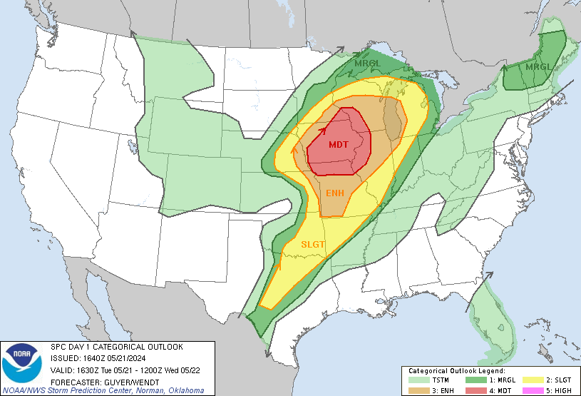
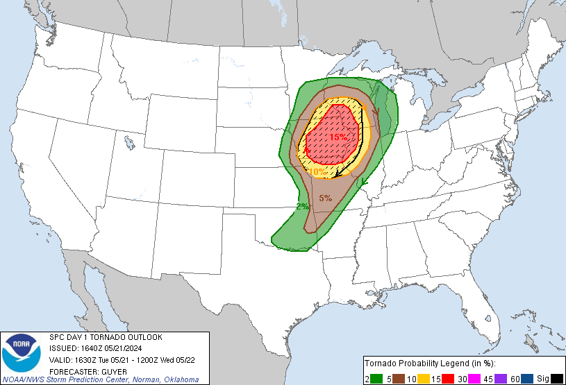
Outlooks and Environment
Storm Prediction Center Outlooks
 |
 |
 |
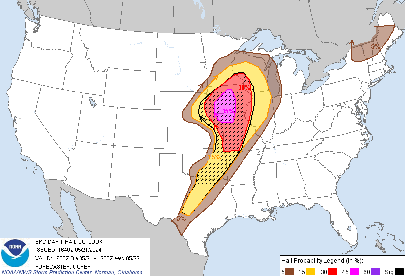 |
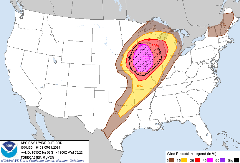
| SPC Day 1 1630z Outlook |
Tornado Risk Probabilities **Sig Severe Likely** |
Severe Wind Risk Probabilities **Sig Severe Likely** |
Severe Hail Risk Probabilities **Sig Severe Likely** |
Watches and Mesoscale Discussions
 |
 |
 |
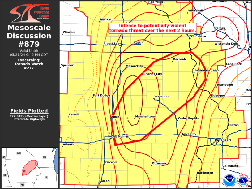 |
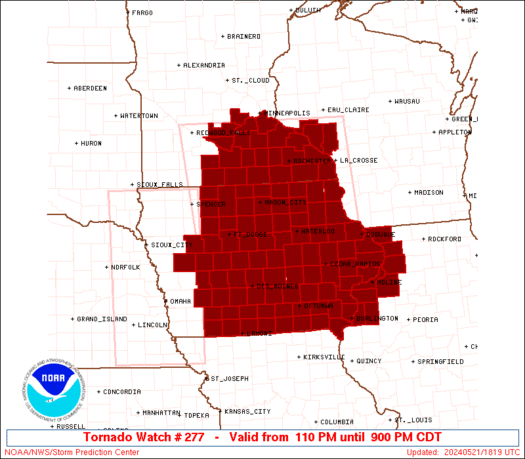
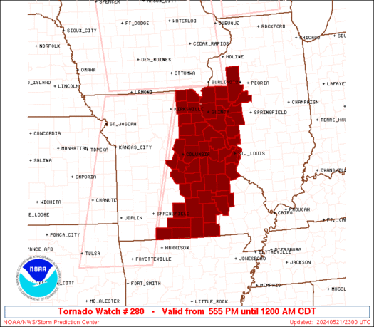
| PDS Tornado Watch #277 | Tornado Watch #280 | Mesoscale Discussion #871 | Mesoscale Discussion #879 |
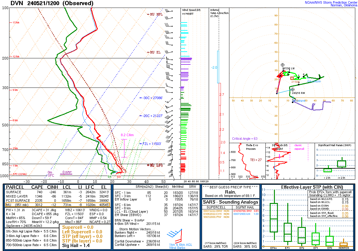
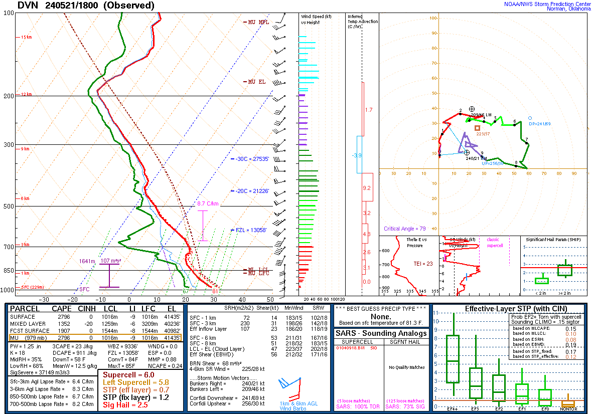
Local Soundings at DVN
 |
 |
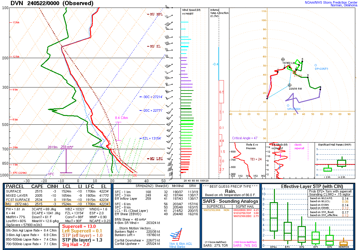 |
| 05/21/2024 - 7:00 am | 05/21/2024 - 1:00 pm | 05/21/2024 7:00 pm |
Synoptic Environment
 |
 |
 |
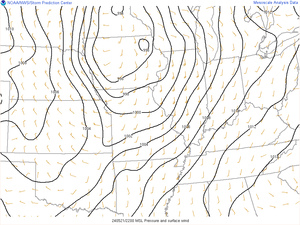 |
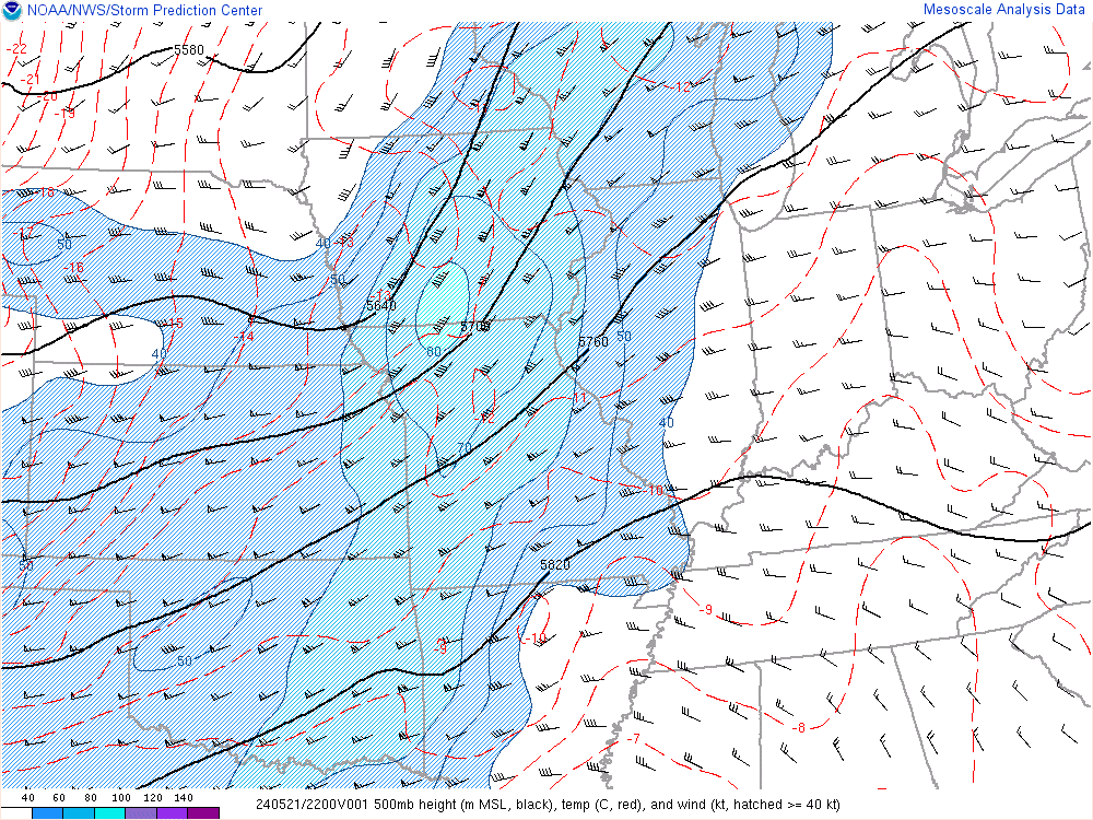
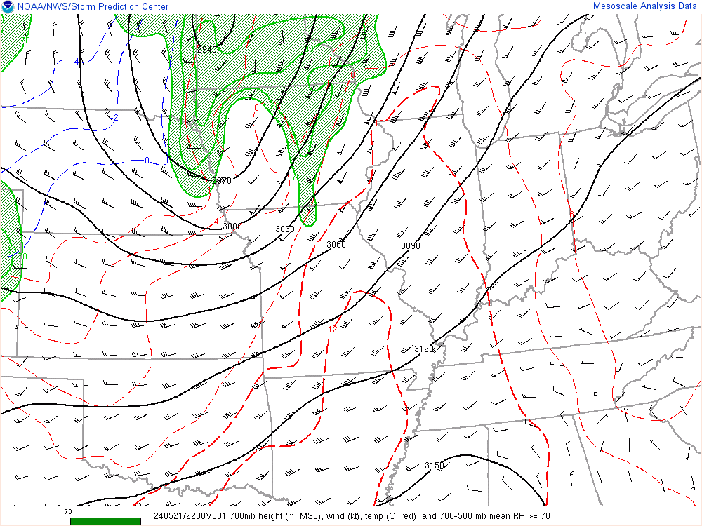
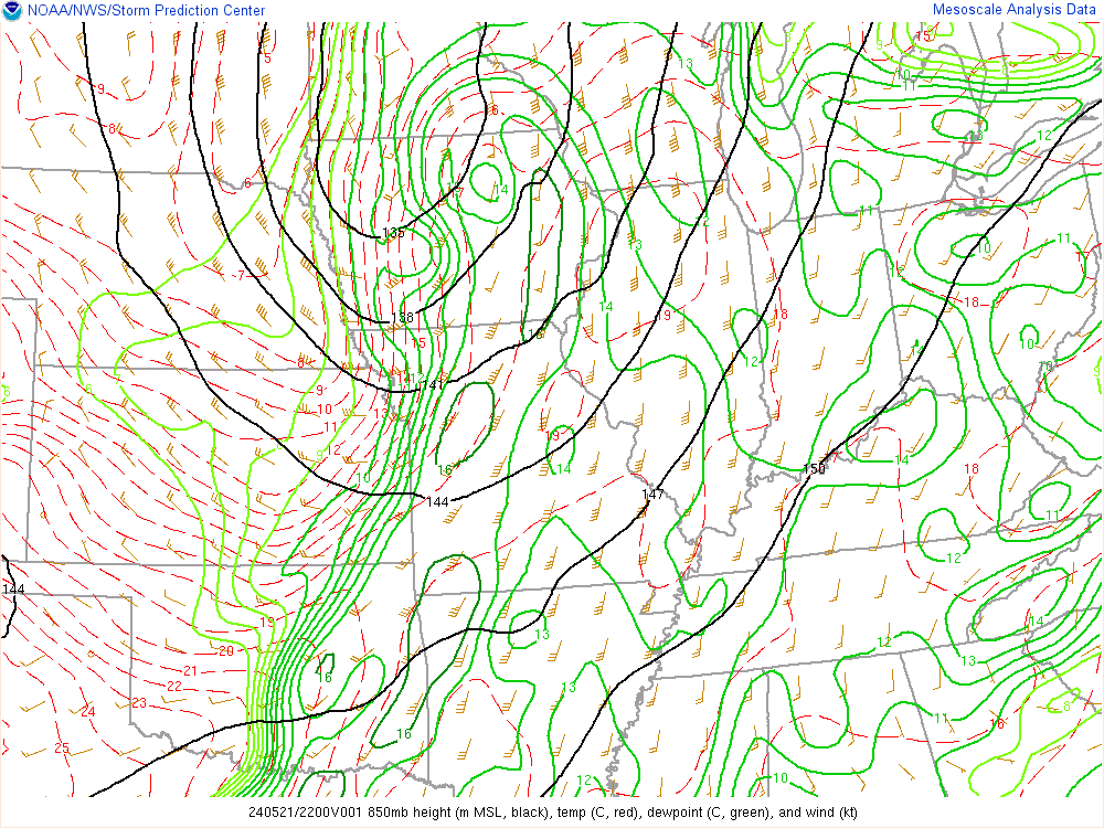
| 500 mb Chart at 5pm | 700 mb Chart at 5pm | 850 mb Chart at 5pm | Surface Chart at 5pm |
Mesoscale Environment
 |
 |
 |
 |
|
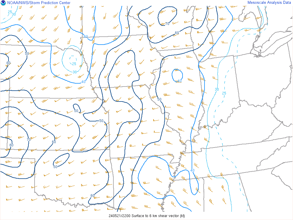
0-6 km Wind Shear Favorable for Organized Convection |
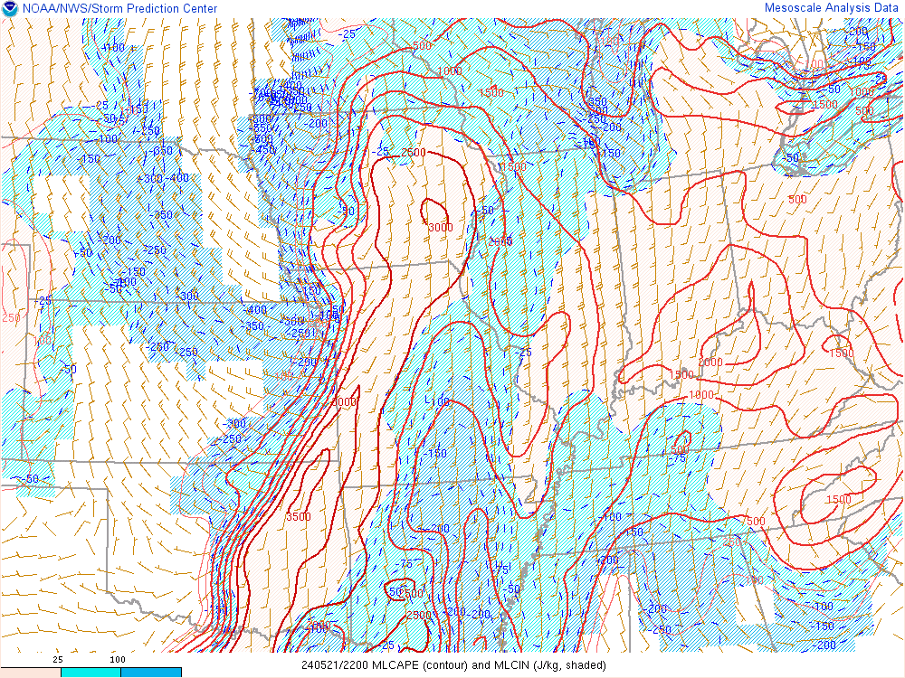
Instability Favorable for Organized Convection |
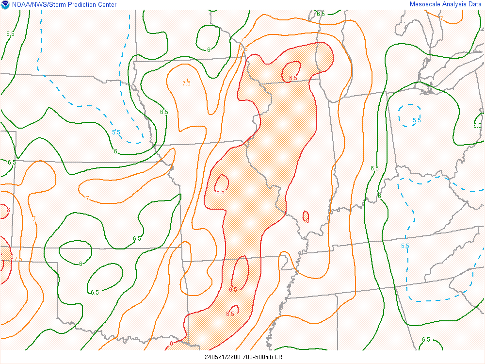
Midlevel Lapse Rates Favorable for Large Hail |
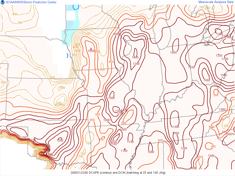
Downdraft CAPE Favorable for Strong Downdrafts |
 |
Media use of NWS Web News Stories is encouraged! |
|