Overview
|
Thunderstorms developed in two rounds, ahead of an advancing cold front and along a warm front. Many of the storms were elevated, and their primary impact was large hail, including reports of larger than baseball sized hail in Osceola, Iowa. This supercell along the warm front later went on to produce a tornado that produced damage in Warren and Marion Counties. Based on eyewitness accounts and video evidence, it is likely that this tornado was intermittent and not a fully continuous path. For simplicity, this will be noted as a single path. Other NWS Office Event Summaries:
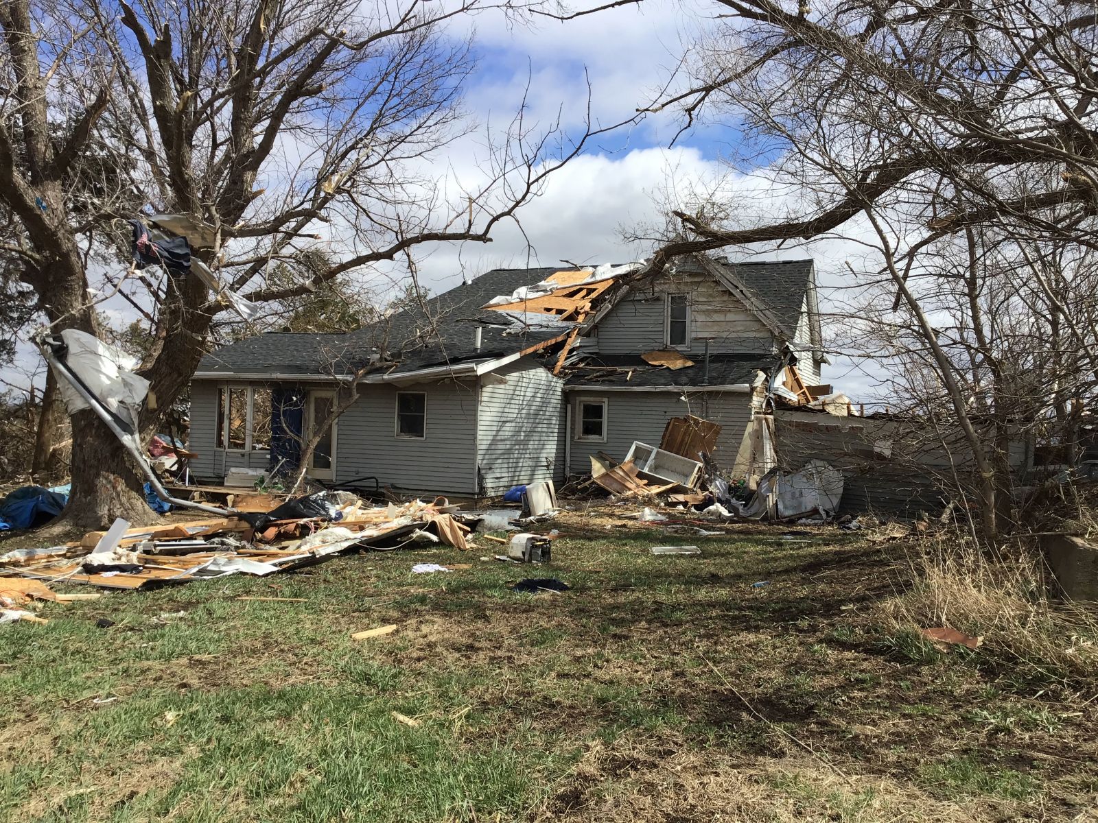
Photo credit: NWS Damage Survey
Last update: April 6th, 2023 at 10:00am CST. |
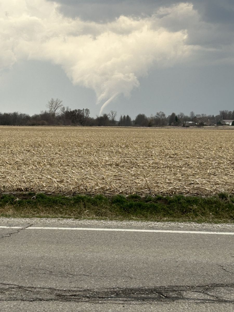
Photo credit: Jesse Castillo / NWS Employee |
 |
 |
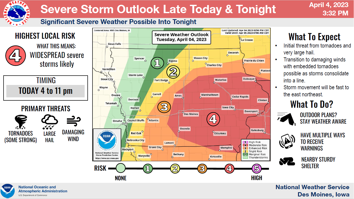
| April 4, 2023 Severe Weather Outlook |
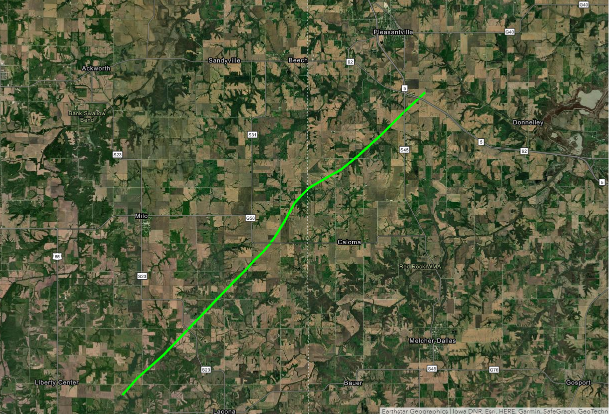
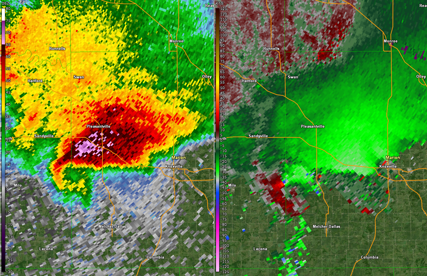
Radar imagery at 6:57pm as the storm crossed from Warren to Marion County. |
Tornadoes:
|
Warren and Marion Counties
|
||||||||||||||||
The Enhanced Fujita (EF) Scale classifies tornadoes into the following categories:
| EF0 Weak 65-85 mph |
EF1 Moderate 86-110 mph |
EF2 Significant 111-135 mph |
EF3 Severe 136-165 mph |
EF4 Extreme 166-200 mph |
EF5 Catastrophic 200+ mph |
 |
|||||
Storm Reports
PRELIMINARY LOCAL STORM REPORT...SUMMARY
NATIONAL WEATHER SERVICE DES MOINES IA
229 AM CDT WED APR 5 2023

..TIME...   ...EVENT...      ...CITY LOCATION...     ...LAT.LON...
..DATE...   ....MAG....      ..COUNTY LOCATION..ST.. ...SOURCE....
            ..REMARKS..

0445 PM     HAIL             2 E NEW MARKET          40.73N 94.86W
04/04/2023  M1.50 INCH       TAYLOR             IA   PUBLIC

            TIME ESTIMATED.

0451 PM     HAIL             4 E NEW MARKET          40.74N 94.82W
04/04/2023  E1.75 INCH       TAYLOR             IA   TRAINED SPOTTER

            GOLF BALL SIZED HAIL.

0506 PM     HAIL             BEDFORD                 40.67N 94.72W
04/04/2023  M1.25 INCH       TAYLOR             IA   PUBLIC


0520 PM     HAIL             ORIENT                  41.20N 94.42W
04/04/2023  E0.88 INCH       ADAIR              IA   EMERGENCY MNGR

            NICKEL SIZED HAIL.

0541 PM     HAIL             EARLHAM                 41.49N 94.12W
04/04/2023  U0.75 INCH       MADISON            IA   PUBLIC


0550 PM     HAIL             1 E BOONE               42.05N 93.86W
04/04/2023  E1.00 INCH       BOONE              IA   TRAINED SPOTTER


0554 PM     HAIL             2 SW BOONE              42.03N 93.91W
04/04/2023  M1.00 INCH       BOONE              IA   PUBLIC

            REPORT FROM SOCIAL MEDIA.

0556 PM     HAIL             2 WNW BOONE             42.06N 93.91W
04/04/2023  E1.25 INCH       BOONE              IA   PUBLIC

            TIME ESTIMATED.

0556 PM     HAIL             1 SSE BOONE             42.04N 93.87W
04/04/2023  E1.00 INCH       BOONE              IA   PUBLIC

            TIME ESTIMATED.

0556 PM     HAIL             5 NNE AFTON             41.09N 94.15W
04/04/2023  E0.50 INCH       UNION              IA   TRAINED SPOTTER

            HALF INCH HAIL.

0605 PM     HAIL             8 S STANHOPE            42.17N 93.81W
04/04/2023  M1.00 INCH       BOONE              IA   TRAINED SPOTTER

            TRAINED SPOTTER REPORTED QUARTER SIZE HAIL
            FROM 602 TO 605 PM AND HALF INCH HAIL FROM
            605 TO 608 PM.

0609 PM     HAIL             2 WNW MESERVEY          42.92N 93.50W
04/04/2023  E1.50 INCH       HANCOCK            IA   TRAINED SPOTTER


0610 PM     HAIL             3 S POLK CITY           41.74N 93.72W
04/04/2023  E0.88 INCH       POLK               IA   NWS EMPLOYEE


0619 PM     HAIL             2 ESE MURRAY            41.03N 93.91W
04/04/2023  E1.00 INCH       CLARKE             IA   LAW ENFORCEMENT


0620 PM     HAIL             NODAWAY                 40.94N 94.90W
04/04/2023  E0.88 INCH       ADAMS              IA   EMERGENCY MNGR


0622 PM     HAIL             3 NNW OSCEOLA           41.07N 93.78W
04/04/2023  E2.75 INCH       CLARKE             IA   PUBLIC

            VIA SOCIAL MEDIA. TIME ESTIMATED FROM RADAR.

0622 PM     HAIL             OSCEOLA                 41.03N 93.78W
04/04/2023  E2.00 INCH       CLARKE             IA   PUBLIC

            VIA SOCIAL MEDIA.

0622 PM     HAIL             1 N OSCEOLA             41.04N 93.77W
04/04/2023  E1.75 INCH       CLARKE             IA   LAW ENFORCEMENT

            GOLF BALL TO SLIGHTLY LARGER.

0623 PM     HAIL             3 NE DES MOINES         41.61N 93.57W
04/04/2023  U0.75 INCH       POLK               IA   PUBLIC

            REPORT FROM MPING.

0623 PM     TSTM WND DMG     1 E OSCEOLA             41.03N 93.75W
04/04/2023                   CLARKE             IA   TRAINED SPOTTER

            SHED BLOWN OVER. TIME ESTIMATED.

0623 PM     HAIL             1 NNE OSCEOLA           41.05N 93.76W
04/04/2023  E2.75 INCH       CLARKE             IA   TRAINED SPOTTER

            TIME ESTIMATED.

0623 PM     HAIL             1 NW OSCEOLA            41.04N 93.79W
04/04/2023  E2.75 INCH       CLARKE             IA   PUBLIC

            REPORT FROM MPING. TIME ESTIMATED.

0624 PM     HAIL             1 SW IOWA FALLS         42.52N 93.27W
04/04/2023  E1.00 INCH       HARDIN             IA   EMERGENCY MNGR


0627 PM     HAIL             5 SE NEW VIRGINIA       41.13N 93.65W
04/04/2023  M3.00 INCH       CLARKE             IA   BROADCAST MEDIA

            CORRECTS PREVIOUS HAIL REPORT FROM 5 SE NEW
            VIRGINIA. THREE INCH HAIL REPORTED ON NEW
            LIBERTY HIGHWAY. TIME ESTIMATED.

0629 PM     HAIL             5 SE NEW VIRGINIA       41.13N 93.65W
04/04/2023  U1.00 INCH       CLARKE             IA   PUBLIC

            REPORT FROM MPING.

0630 PM     HAIL             5 ESE NEW VIRGINIA      41.14N 93.64W
04/04/2023  E3.00 INCH       CLARKE             IA   TRAINED SPOTTER


0630 PM     HAIL             4 W INDIANOLA           41.35N 93.65W
04/04/2023  E1.25 INCH       WARREN             IA   TRAINED SPOTTER


0635 PM     HAIL             7 S INDIANOLA           41.26N 93.58W
04/04/2023  E1.00 INCH       WARREN             IA   PUBLIC

            REPORT FROM MPING.

0635 PM     HAIL             7 E NEW VIRGINIA        41.19N 93.60W
04/04/2023  E1.25 INCH       WARREN             IA   TRAINED SPOTTER


0636 PM     HAIL             5 W LACONA              41.20N 93.49W
04/04/2023  E1.00 INCH       WARREN             IA   EMERGENCY MNGR

            1 INCH HAIL NEAR LIBERTY CENTER.

0636 PM     HAIL             3 SSE SAINT MARYS       41.26N 93.72W
04/04/2023  U1.00 INCH       WARREN             IA   PUBLIC

            REPORT FROM MPING.

0640 PM     HAIL             3 E SAINT MARYS         41.31N 93.67W
04/04/2023  M1.00 INCH       WARREN             IA   PUBLIC


0647 PM     HAIL             4 W INDIANOLA           41.35N 93.65W
04/04/2023  M2.50 INCH       WARREN             IA   TRAINED SPOTTER


0650 PM     HAIL             8 ENE NEW VIRGINIA      41.21N 93.58W
04/04/2023  U2.00 INCH       WARREN             IA   PUBLIC

            REPORT FROM MPING.

0650 PM     HAIL             2 S DUMONT              42.72N 92.97W
04/04/2023  E0.88 INCH       BUTLER             IA   EMERGENCY MNGR


0654 PM     HAIL             3 NNE OSCEOLA           41.07N 93.76W
04/04/2023  U3.50 INCH       CLARKE             IA   PUBLIC

            REPORT FROM MPING.

0656 PM     TORNADO          4 SSE SANDYVILLE        41.32N 93.35W
04/04/2023                   WARREN             IA   PUBLIC

            TORNADO TOUCHDOWN BUT UP AND DOWN.

0657 PM     HAIL             5 SE COLLINS            41.85N 93.25W
04/04/2023  U1.00 INCH       JASPER             IA   PUBLIC

            REPORT FROM MPING.

0657 PM     HAIL             2 S PLEASANTVILLE       41.36N 93.26W
04/04/2023  E1.25 INCH       MARION             IA   TRAINED SPOTTER

            HALF DOLLAR HAIL.

0657 PM     TORNADO          4 ESE MILO              41.26N 93.37W
04/04/2023                   WARREN             IA   EMERGENCY MNGR

            DEBRIS REPORTED SOUTHEAST OF MILO.

0658 PM     HAIL             3 WNW ORIENT            41.21N 94.47W
04/04/2023  E1.00 INCH       ADAIR              IA   TRAINED SPOTTER


0658 PM     FUNNEL CLOUD     5 SE PLEASANTVILLE      41.35N 93.19W
04/04/2023                   MARION             IA   EMERGENCY MNGR


0702 PM     HAIL             ORIENT                  41.20N 94.42W
04/04/2023  E1.75 INCH       ADAIR              IA   EMERGENCY MNGR


0704 PM     TORNADO          2 SE PLEASANTVILLE      41.37N 93.24W
04/04/2023                   MARION             IA   TRAINED SPOTTER


0705 PM     HAIL             MELBOURNE               41.94N 93.11W
04/04/2023  U1.00 INCH       MARSHALL           IA   PUBLIC

            REPORT FROM MPING.

0730 PM     HAIL             SULLY                   41.58N 92.84W
04/04/2023  E1.00 INCH       JASPER             IA   TRAINED SPOTTER

            REPORTED BY TRAINED SPOTTER.

0733 PM     HAIL             SULLY                   41.58N 92.84W
04/04/2023  E1.50 INCH       JASPER             IA   TRAINED SPOTTER

            TIME ESTIMATED.

0738 PM     HAIL             3 E ORIENT              41.20N 94.36W
04/04/2023  E0.88 INCH       ADAIR              IA   EMERGENCY MNGR


0800 PM     HAIL             1 S CLIVE               41.59N 93.77W
04/04/2023  E0.50 INCH       POLK               IA   TRAINED SPOTTER

            HALF INCH HAIL. TIME ESTIMATED.

0800 PM     HAIL             3 SSW BEDFORD           40.64N 94.75W
04/04/2023  U1.00 INCH       TAYLOR             IA   PUBLIC

            REPORT FROM MPING.

0806 PM     HAIL             6 NNW MALCOM            41.80N 92.59W
04/04/2023  E1.00 INCH       POWESHIEK          IA   TRAINED SPOTTER


0807 PM     HAIL             3 NE DES MOINES         41.61N 93.57W
04/04/2023  E1.00 INCH       POLK               IA   PUBLIC

            REPORT FROM MPING.

0822 PM     FUNNEL CLOUD     3 ENE COLFAX            41.69N 93.18W
04/04/2023                   JASPER             IA   TRAINED SPOTTER

            POSSIBLE FUNNEL CLOUD LOOKING WEST.

0822 PM     HAIL             1 NW ALTOONA            41.66N 93.48W
04/04/2023  E0.88 INCH       POLK               IA   FIRE DEPT/RESCUE


0823 PM     HAIL             VINING                  41.99N 92.39W
04/04/2023  E1.00 INCH       TAMA               IA   LAW ENFORCEMENT

            HEAVY WINDS AND QUARTER SIZE HAIL REPORTED
            NEAR VINING.

0852 PM     HAIL             3 N MARTENSDALE         41.42N 93.75W
04/04/2023  E1.00 INCH       WARREN             IA   PUBLIC

            REPORT FROM MPING.

0854 PM     HAIL             BAXTER                  41.82N 93.15W
04/04/2023  E1.75 INCH       JASPER             IA   PUBLIC

            REPORTED VIA SOCIAL MEDIA.

0854 PM     HAIL             BAXTER                  41.83N 93.15W
04/04/2023  E1.00 INCH       JASPER             IA   FIRE DEPT/RESCUE


0855 PM     HAIL             SAINT CHARLES           41.29N 93.81W
04/04/2023  E1.75 INCH       MADISON            IA   EMERGENCY MNGR


0857 PM     HAIL             1 S WEST DES MOINES     41.55N 93.75W
04/04/2023  E1.00 INCH       POLK               IA   PUBLIC

            REPORT FROM MPING.

0905 PM     HAIL             LAUREL                  41.89N 92.92W
04/04/2023  M1.00 INCH       MARSHALL           IA   PUBLIC

            IMAGE SUBMITTED VIA SOCIAL MEDIA.

0910 PM     HAIL             MOUNT AYR               40.71N 94.25W
04/04/2023  E0.50 INCH       RINGGOLD           IA   TRAINED SPOTTER

            HALF INCH HAIL.

0929 PM     HAIL             PLEASANT HILL           41.59N 93.52W
04/04/2023  U1.00 INCH       POLK               IA   PUBLIC

            REPORT FROM MPING: QUARTER (1.00 IN.).

0957 PM     HAIL             6 NE MARSHALLTOWN       42.10N 92.84W
04/04/2023  M0.25 INCH       MARSHALL           IA   PUBLIC

            REPORTED BY TRAINED SPOTTER.

0959 PM     HAIL             7 NE MARSHALLTOWN       42.10N 92.82W
04/04/2023  M0.50 INCH       MARSHALL           IA   PUBLIC

            REPORTED BY TRAINED SPOTTER.

1026 PM     TSTM WND DMG     GRUNDY CENTER           42.36N 92.77W
04/04/2023                   GRUNDY             IA   PUBLIC

            1-INCH TREE LIMBS BROKEN; SHINGLES BLOWN OFF.

1053 PM     NON-TSTM WND GST 4 E ALBION              42.12N 92.92W
04/04/2023  M58 MPH          MARSHALL           IA   ASOS

            ASOS STATION KMIW MARSHALLTOWN AIRPORT. POSSIBLE WAKE LOW.

1135 PM     NON-TSTM WND GST WATERLOO REGIONAL AIRPO 42.55N 92.40W
04/04/2023  M58 MPH          BLACK HAWK         IA   ASOS

            ASOS STATION KALO WATERLOO AIRPORT. POSSIBLE WAKE LOW.
 |
Media use of NWS Web News Stories is encouraged! Please acknowledge the NWS as the source of any news information accessed from this site. |
|