Severe weather and flooding threats will continue for portions of the central U.S. over the next couple of days, with multiple rounds of thunderstorms expected. Dangerous heat will persist across the southern and western U.S. through mid-week. Hot and dry conditions will fuel fire weather concerns for the Intermountain West, where dry thunderstorms may spark additional wildfires. Read More >
Event Overview: January 12th, 2019
|
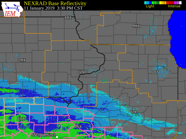
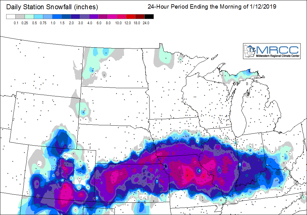
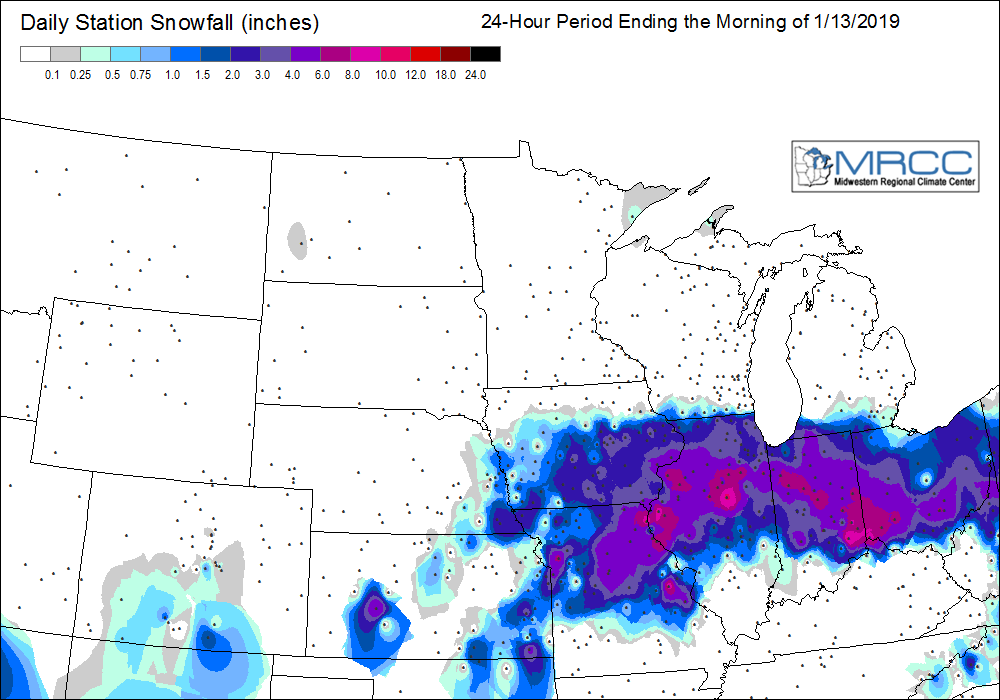
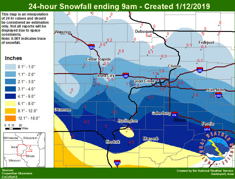
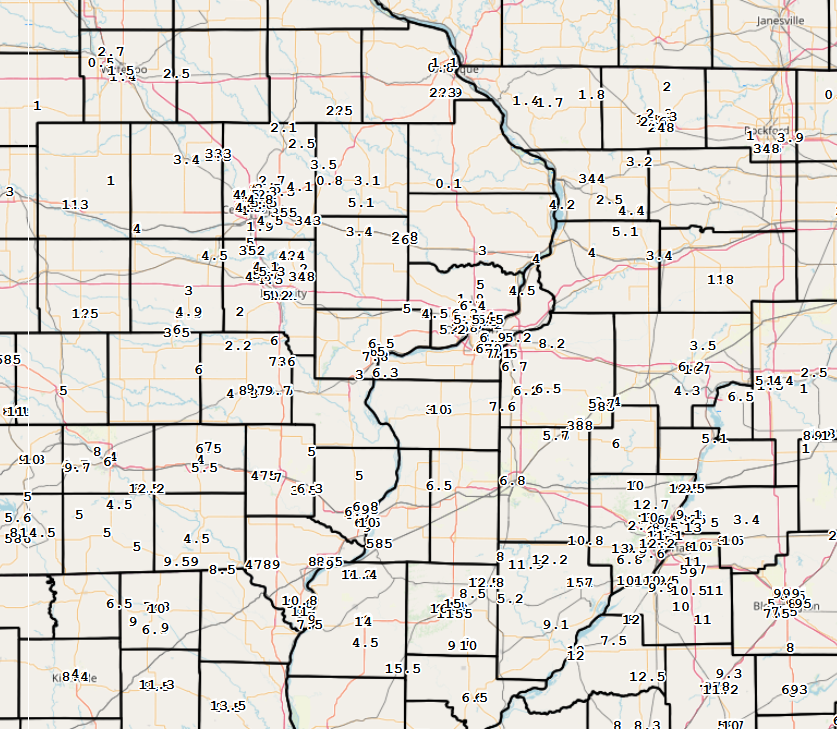
A strong area of low pressure tracked across the lower Mississippi River Valley, bringing heavy snow from central Missouri and southern Illinois up to eastern Iowa and northwest Illinois Friday night (Jan. 11) and Saturday (Jan. 12). The heaviest amounts fell from Missouri into Ohio, where amounts over a foot were common. Further north, snowfall totals ranged from around 1-3 inches along the Highway 20 corridor, to 4-8 inches around the I-80 corridor, to 8-12 inches along and south of Highway 34. Isolated amounts of over a foot were reported from Macomb, Bushnell, and Carthage.
Surrounding Office Event Summaries |
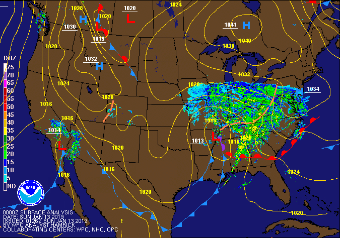 Surface Analysis (Courtesy Weather Prediction Center) |
Snowfall Maps
| Regional Snowfall January 12th, 2019 |
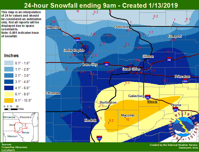
Regional Snowfall January 13th, 2019 |
Local Snowfall January 12th. 2019 |
Local Snowfall January 13th, 2019 |
 |
 |
 |
 |
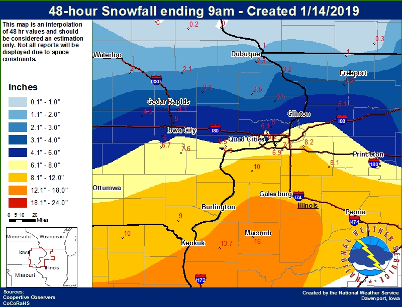
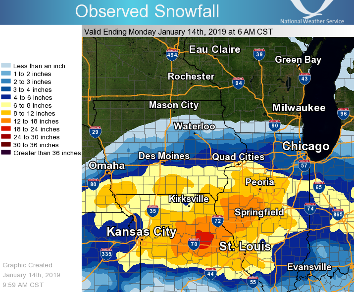
| 48-hr Local Snowfall Map | Midwest Snow Totals |
 |
 |
Storm Reports
| Interactive Snow Report Map |
 |
PRELIMINARY LOCAL STORM REPORT...SUMMARY NATIONAL WEATHER SERVICE QUAD CITIES IA IL 1056 AM CST MON JAN 14 2019 THE REPORTS BELOW ARE SEPARATED INTO SNOW...AND ICE AND SLEET CATEGORIES...THEN BY AMOUNT...AND ARE NOT NECESSARILY THE FINAL AMOUNT FOR EACH LOCATION. SNOW REPORTS LISTED BY AMOUNT MORNING REPORTS (I.E. "AM") ARE MAINLY FROM JAN 13 WHILE AFTERNOON/EVENING REPORTS (I.E. "PM") ARE FROM JAN 12. INCHES LOCATION ST COUNTY TIME ------ ----------------------- -- -------------- ------- 16.0 3 W MACOMB IL MCDONOUGH 0700 AM 15.5 1 ENE AUGUSTA IL HANCOCK 0938 AM 15.0 2 SSE MACOMB IL MCDONOUGH 0841 AM 14.0 1 E MACOMB IL MCDONOUGH 0244 AM 14.0 CARTHAGE IL HANCOCK 0645 AM 13.7 1 SSW BENTLEY IL HANCOCK 0800 AM 13.5 BUSHNELL IL MCDONOUGH 0557 PM 12.8 BUSHNELL IL MCDONOUGH 0900 AM 11.4 2 NE COLUSA IL HANCOCK 0700 AM 11.0 MOOAR IA LEE 0253 PM 10.9 2 NNE COLUSA IL HANCOCK 0700 AM 10.8 2 N SUMMITVILLE IA LEE 0900 PM 10.0 MEMPHIS MO SCOTLAND 0600 AM 10.0 1 SSE INDUSTRY IL MCDONOUGH 0607 PM 10.0 1 ENE BURLINGTON REGION IA DES MOINES 0923 PM 10.0 1 N ALEDO IL MERCER 0700 AM 9.7 1 W AINSWORTH IA WASHINGTON 0219 PM 9.5 2 W INDUSTRY IL MCDONOUGH 0344 PM 9.5 CANTRIL IA VAN BUREN 0949 AM 9.0 WASHINGTON IA WASHINGTON 0155 PM 9.0 5 SSE MEMPHIS MO SCOTLAND 0515 PM 9.0 3 WNW MOUNT STERLING IA VAN BUREN 0840 AM 9.0 LA HARPE IL HANCOCK 0800 AM 9.0 INDUSTRY IL MCDONOUGH 0200 PM 9.0 3 ENE FORT MADISON IA LEE 0810 PM 9.0 1 S DONNELLSON IA LEE 0700 AM 9.0 4 S CRAWFORD MO SCOTLAND 0910 AM 9.0 1 ESE BURLINGTON REGION IA DES MOINES 0300 PM 9.0 BURLINGTON IA DES MOINES 0535 PM 9.0 2 N BURLINGTON IA DES MOINES 0951 PM 8.7 1 SE WASHINGTON IA WASHINGTON 0317 PM 8.5 3 SE FORT MADISON MUNIC IA LEE 0230 PM 8.5 1 NE FORT MADISON IA LEE 0605 PM 8.5 3 NE CHARLIE HEATH MEMO MO CLARK 0424 PM 8.2 1 ENE MONTPELIER IA SCOTT 0900 AM 8.2 2 NW GENESEO IL HENRY 0730 AM 8.1 1 ENE KEWANEE IL HENRY 0700 AM 8.0 1 SSW KEWANEE IL HENRY 0800 AM 8.0 GALVA IL HENRY 0515 PM 8.0 2 SE CARMAN IL HENDERSON 1024 AM 7.8 MUSCATINE IA MUSCATINE 0911 PM 7.8 MEMPHIS MO SCOTLAND 0315 PM 7.6 2 NE NEW WINDSOR IL HENRY 0649 AM 7.6 4 N HASKINS IA WASHINGTON 0700 AM 7.5 1 SSE KEOKUK IA LEE 1057 AM 7.5 2 SE COAL VALLEY IL HENRY 0700 AM 7.1 1 S COAL VALLEY IL ROCK ISLAND 0845 AM 7.0 1 SW PERLEE IA JEFFERSON 0600 AM 7.0 2 NNW OAKLAND MILLS IA HENRY 0530 PM 7.0 1 W MOUNT PLEASANT IA HENRY 0528 PM 7.0 2 NNE FAIRFIELD IA JEFFERSON 0800 AM 7.0 4 NNE CROTON IA LEE 0625 PM 6.9 MOLINE QUAD-CITY AIRPOR IL ROCK ISLAND 1213 AM 6.9 1 NNE MOLINE IL ROCK ISLAND 0700 AM 6.7 3 W RICHMOND IA WASHINGTON 0700 AM 6.7 2 N ORION IL HENRY 0630 PM 6.5 1 E WEST BURLINGTON IA DES MOINES 0300 PM 6.5 4 NNE MUSCATINE IA MUSCATINE 0700 AM 6.5 1 N GRANVILLE IL PUTNAM 1147 PM 6.5 4 SW ELEANOR IL WARREN 0715 PM 6.5 1 WNW CAMBRIDGE IL HENRY 0907 PM 6.4 DAVENPORT MUNICIPALITY IA SCOTT 1215 AM 6.3 1 ENE RIVERDALE IA SCOTT 0630 AM 6.3 1 ESE NEW LONDON IA HENRY 0730 AM 6.3 5 NNW ELIZA IL ROCK ISLAND 1115 AM 6.3 2 NNW DAVENPORT IA SCOTT 0745 AM 6.2 1 WNW PRINCETON IL BUREAU 0700 AM 6.2 2 SSE DAVENPORT IA SCOTT 0630 AM 6.2 1 W CAMBRIDGE IL HENRY 0400 PM 6.2 1 W ANDOVER IL HENRY 0544 PM 6.0 RIVERSIDE IA WASHINGTON 0400 PM 6.0 1 SE PRINCETON IL BUREAU 0949 PM 6.0 NORTH ENGLISH IA IOWA 1113 PM 6.0 2 NNW MUSCATINE IA MUSCATINE 0452 PM 6.0 LOWDEN IA CEDAR 0904 PM 6.0 KEOTA IA KEOKUK 1119 AM 6.0 2 N CREDIT ISLAND IA SCOTT 0800 PM 5.8 2 N MUSCATINE IA MUSCATINE 0700 AM 5.7 1 SW NORTH LIBERTY IA JOHNSON 0700 PM 5.5 2 ESE FAIRFIELD IA JEFFERSON 0240 PM 5.5 2 NNW DAVENPORT IA SCOTT 0500 PM 5.5 1 SE DAVENPORT IA SCOTT 0645 AM 5.5 1 NW DAVENPORT IA SCOTT 0857 AM 5.5 3 NE CEDAR RAPIDS IA LINN 0600 AM 5.5 3 WSW BETTENDORF IA SCOTT 0745 PM 5.5 1 W BETTENDORF IA SCOTT 0930 PM 5.3 1 ESE NORTH LIBERTY IA JOHNSON 0830 PM 5.2 1 WSW UNIVERSITY HEIGHT IA JOHNSON 0935 PM 5.2 2 E SPRING LAKE IA SCOTT 0856 PM 5.2 COLONA IL HENRY 0235 PM 5.1 OLIN IA JONES 0555 PM 5.1 1 SSW COLETA IL WHITESIDE 0745 AM 5.0 2 NNW WILLIAMSTOWN IA JOHNSON 0700 AM 5.0 SWISHER IA JOHNSON 0551 PM 5.0 2 N SPERRY IA DES MOINES 1235 PM 5.0 PARK VIEW IA SCOTT 0700 AM 5.0 1 SSW NORTH LIBERTY IA JOHNSON 0800 AM 5.0 2 NNE MUSCATINE IA MUSCATINE 0305 PM 5.0 MOUNT UNION IA HENRY 0637 PM 5.0 DURANT IA CEDAR 0520 PM 5.0 1 W COU FALLS IA JOHNSON 0736 PM 5.0 BERTRAM IA LINN 0837 AM 4.9 PARNELL IA IOWA 0839 PM 4.8 2 W CEDAR RAPIDS IA LINN 0900 PM 4.8 3 NNE CEDAR RAPIDS IA LINN 0705 AM 4.6 2 NE CEDAR RAPIDS IA LINN 1030 PM 4.5 1 NNE WEST AMANA IA IOWA 0700 AM 4.5 1 S WALCOTT IA SCOTT 0845 PM 4.5 1 NE TIFFIN IA JOHNSON 0700 PM 4.5 1 N OAKDALE IA JOHNSON 0619 PM 4.5 2 WSW HIAWATHA IA LINN 0800 PM 4.5 1 SSW CORDOVA IL ROCK ISLAND 0555 PM 4.5 3 W BERTRAM IA LINN 0303 PM 4.5 1 W AMANA IA IOWA 0848 PM 4.4 SOLON IA JOHNSON 0700 AM 4.4 SOLON IA JOHNSON 0735 PM 4.4 MILLEDGEVILLE IL CARROLL 1112 PM 4.3 TISKILWA IL BUREAU 1135 AM 4.3 2 NNE CEDAR RAPIDS IA LINN 0510 PM 4.2 UNIVERSITY HEIGHTS IA JOHNSON 0300 PM 4.2 3 NW THOMSON IL CARROLL 1130 PM 4.2 1 SW HIAWATHA IA LINN 0746 PM 4.1 SPRINGVILLE IA LINN 0800 PM 4.1 2 NNW NORTH LIBERTY IA JOHNSON 0800 PM 4.0 4 SSE WEST CHESTER IA WASHINGTON 0158 PM 4.0 UNIONVILLE IL WHITESIDE 0900 PM 4.0 MOUNT CARROLL IL CARROLL 0930 PM 4.0 1 ENE MOUNT VERNON IA LINN 0850 AM 4.0 1 NE HIAWATHA IA LINN 0245 PM 4.0 FREEPORT IL STEPHENSON 0900 AM 4.0 1 W ELMIRA IA JOHNSON 0845 PM 4.0 3 W CEDAR RAPIDS IA LINN 0900 PM 4.0 1 E CAMANCHE IA CLINTON 0600 PM 4.0 1 WNW BETTENDORF IA SCOTT 0140 PM 4.0 BELLE PLAINE IA BENTON 0530 PM 3.6 2 WNW CEDAR RAPIDS IA LINN 0205 PM 3.5 2 NNE STONE CITY IA JONES 0444 PM 3.5 2 NW MARION IA LINN 0500 PM 3.5 2 E MARION IA LINN 0520 PM 3.5 2 WNW CHARLOTTE IA CLINTON 0700 AM 3.5 6NNE PRINCETON IL BUREAU 0200 PM 3.4 VINTON IA BENTON 0920 PM 3.4 3 E STERLING IL WHITESIDE 0438 PM 3.4 STANWOOD IA CEDAR 0630 PM 3.3 3 S URBANA IA BENTON 0803 PM 3.3 NW CEDAR RAPIDS IA LINN 0123 PM 3.3 2 ESE FAIRVIEW IA JONES 0700 AM 3.2 SHANNON IL CARROLL 0855 AM 3.1 3 SW CENTER JUNCTION IA JONES 0509 PM 3.0 WILLIAMSBURG IA IOWA 0500 PM 3.0 3 SW WINNESHIEK IL STEPHENSON 0857 AM 3.0 2 NW FREEPORT IL STEPHENSON 0730 AM 3.0 1 E DEWITT IA CLINTON 0123 PM 3.0 3 ENE BOLTON IL STEPHENSON 0730 AM 2.8 FREEPORT IL STEPHENSON 0914 PM 2.7 3 N MARION IA LINN 0258 PM 2.6 2 WNW FREEPORT IL STEPHENSON 1055 PM 2.5 2 SW PRAIRIEBURG IA LINN 0702 PM 2.5 MAQUOKETA IA JACKSON 0700 AM 2.5 1 NNW JESUP IA BUCHANAN 0500 PM 2.5 HOPKINTON IA DELAWARE 1133 PM 2.5 CHADWICK IL CARROLL 0442 PM 2.3 2 SE SCIOTO MILLS IL STEPHENSON 0645 PM 2.3 1 NW DUBUQUE REGIONAL A IA DUBUQUE 0600 AM 2.3 1 WNW CEDAR RAPIDS IA LINN 1115 AM 2.1 COGGON IA LINN 0500 AM 2.0 2 NNW MOUNT AUBURN IA BENTON 0600 AM 2.0 2 W AFOLKEY IL STEPHENSON 0700 AM 1.8 3 NNE STOCKTON IL JO DAVIESS 0830 PM 1.7 2 SSE SCHAPVILLE IL JO DAVIESS 0853 AM 1.5 3 WNW FREEPORT IL STEPHENSON 0415 PM 1.4 2 SE GALENA TERRITORY IL JO DAVIESS 0429 PM 1.1 2 WNW DUBUQUE IA DUBUQUE 0720 PM 1.0 3 NNE MC CONNELL IL STEPHENSON 0700 AM 1.0 2 ESE EDMORE IA DUBUQUE 0600 AM 0.8 2 SE ASBURY IA DUBUQUE 0335 PM 0.5 5 SW LAMONT IA BUCHANAN 0900 AM |
 |
Media use of NWS Web News Stories is encouraged! Please acknowledge the NWS as the source of any news information accessed from this site. |
|