Scattered thunderstorms with severe gusts, hail and a tornado risk are possible near a cold front from the Ohio Valley to the Mid-Atlantic tonight. Tropical Storm Bertha is expected to bring tropical storm conditions to portions of the Gulf Coast from the panhandle of Florida into Louisiana through Wednesday. Read More >
Overview
|
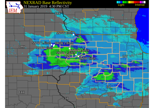
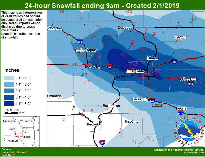
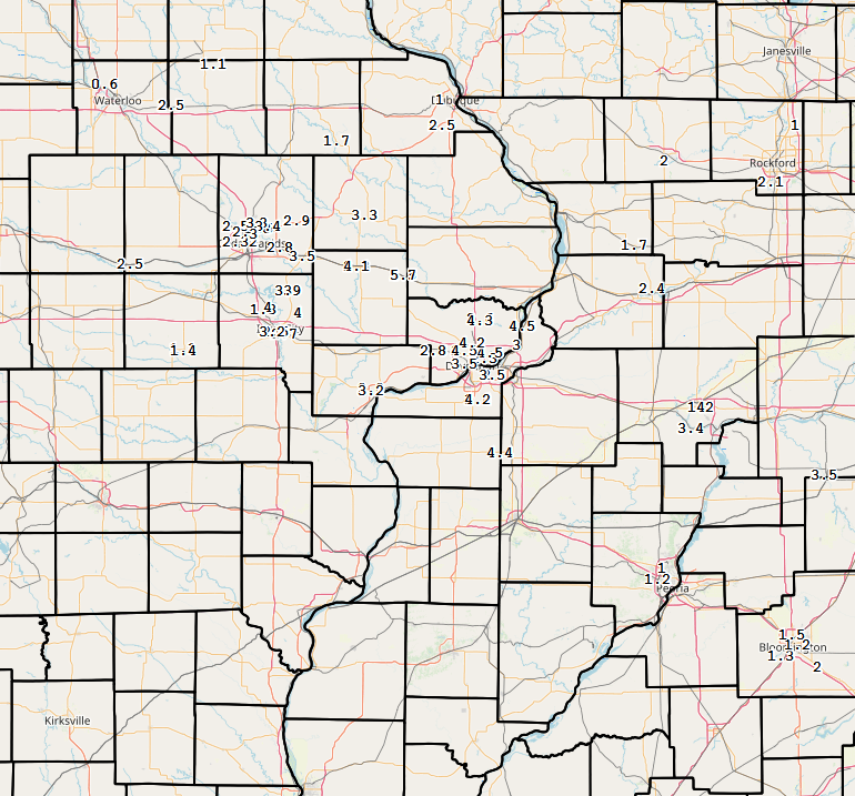
An upper level storm system tracked east across Iowa Thursday afternoon and evening bringing light and fluffy snow to much of eastern Iowa and northwest Illinois. Snowfall totals between 2-4 inches were common mainly along a line from Cedar Rapids, to the Quad Cities, to Princeton Illinois. Lighter amounts were seen north and south of this line. Several accidents occurred on I-80 and on other major roads that caused long delays for motorists. Temperatures were in the single digits below zero during this event.
|
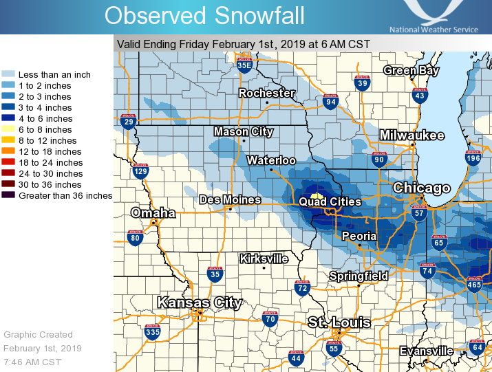 Regional Snowfall Regional Snowfall |
Snow
| Local Snowfall Map | Regional LSR Analysis Snowfall Map - Courtesy IEM |
 |
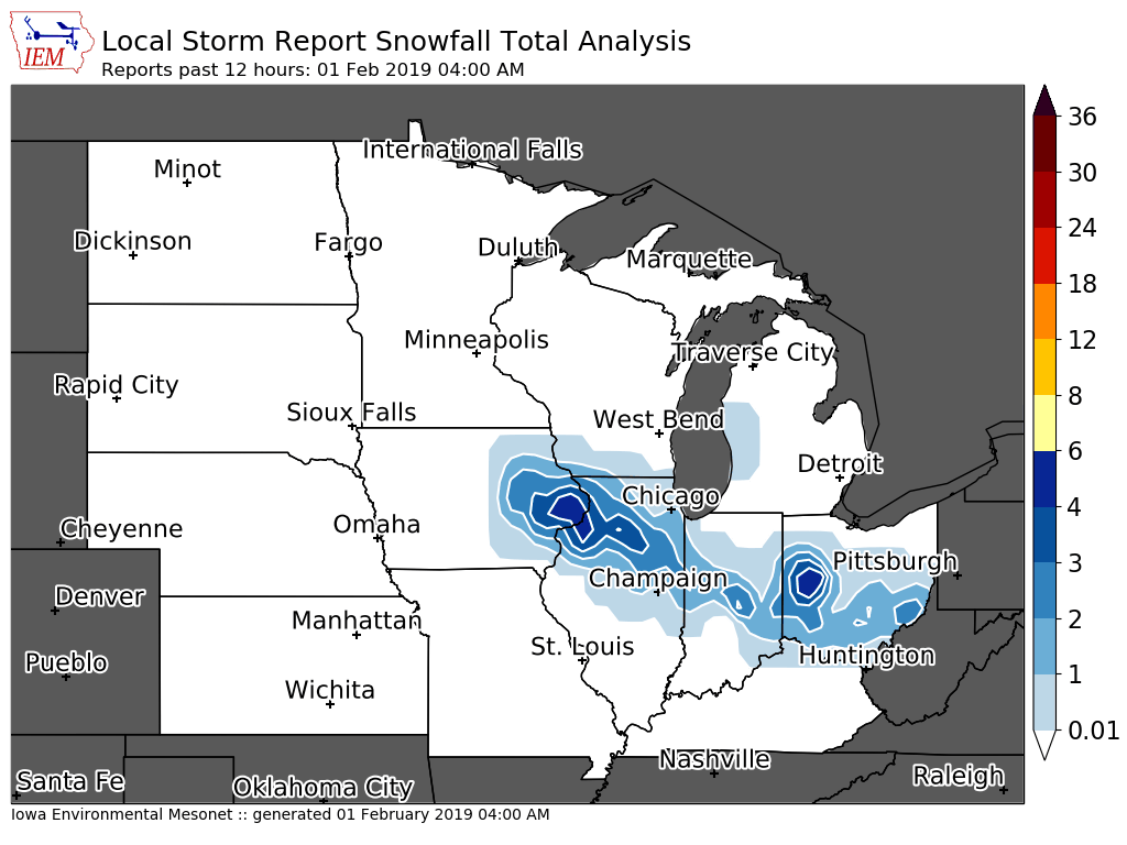 |
Interactive Storm Reports Map - Courtesy IEM
 |
|
|
|
SNOW REPORTS LISTED BY AMOUNT INCHES LOCATION ST COUNTY TIME ------ ----------------------- -- -------------- ------- 5.7 LOWDEN IA CEDAR 0824 PM 5.3 1 N RIVERDALE IA SCOTT 0700 AM 4.5 1 SW CORDOVA IL ROCK ISLAND 1002 PM 4.5 2 NW DAVENPORT IA SCOTT 0837 PM 4.5 1 WNW BETTENDORF IA SCOTT 0830 PM 4.4 2 N NEW WINDSOR IL HENRY 1018 PM 4.3 PARK VIEW IA SCOTT 0831 PM 4.2 2 NW GENESEO IL HENRY 0500 AM 4.2 DAVENPORT MUNICIPALITY IA SCOTT 1225 AM 4.2 MOLINE QUAD-CITY AIRPOR IL ROCK ISLAND 1221 AM 4.1 STANWOOD IA CEDAR 0800 PM 4.0 GALVA IL HENRY 0749 AM 4.0 1 WNW PRINCETON IL BUREAU 0700 AM 4.0 6 W ILLINOIS CITY IL ROCK ISLAND 0600 AM 4.0 2 SSE DAVENPORT IA SCOTT 0530 AM 4.0 1 SE PRINCETON IL BUREAU 1019 PM 4.0 1 W ELMIRA IA JOHNSON 0840 PM 4.0 1 ESE NORTH LIBERTY IA JOHNSON 0630 PM 3.9 1 ENE KEWANEE IL HENRY 0700 AM 3.9 SOLON IA JOHNSON 0700 PM 3.5 1 NNE MOLINE IL ROCK ISLAND 0320 AM 3.5 1 NE MOUNT VERNON IA LINN 0905 PM 3.5 2 N CREDIT ISLAND IA SCOTT 0805 PM 3.4 TISKILWA IL BUREAU 1052 PM 3.4 MARION IA LINN 0610 PM 3.3 3 SW CENTER JUNCTION IA JONES 0751 PM 3.2 1 NNW MUSCATINE IA MUSCATINE 0517 AM 3.2 1 SW UNIVERSITY HEIGHTS IA JOHNSON 1033 PM 3.1 BERTRAM IA LINN 0743 AM 3.0 1 SE DAVENPORT IA SCOTT 0700 AM 3.0 3 NNE CEDAR RAPIDS IA LINN 0915 PM 3.0 LE CLAIRE IA SCOTT 0846 PM 3.0 2 NW MARION IA LINN 0600 PM 3.0 HIAWATHA IA LINN 0500 PM 2.9 SPRINGVILLE IA LINN 0809 PM 2.8 4 NNE MUSCATINE IA MUSCATINE 0700 AM 2.8 2 ESE FAIRVIEW IA JONES 0600 AM 2.8 1 S WALCOTT IA SCOTT 0825 PM 2.8 3 ESE HIAWATHA IA LINN 0430 PM 2.7 2 NNW WARNER IL HENRY 0700 AM 2.7 2 SE IOWA CITY IA JOHNSON 0545 PM 2.7 2 SSW HIAWATHA IA LINN 0516 PM 2.5 1 SSW KEWANEE IL HENRY 0725 AM 2.5 2 W MAQUOKETA IA JACKSON 0700 AM 2.5 DUBUQUE REGIONAL ARPT IA DUBUQUE 1223 AM 2.5 UNIVERSITY HEIGHTS IA JOHNSON 0745 PM 2.5 JESUP IA BUCHANAN 0630 PM 2.5 BELLE PLAINE IA BENTON 0515 PM 2.5 3 SE PALO IA LINN 0434 PM 2.4 COGGON IA LINN 0500 AM 2.4 1 N STERLING IL WHITESIDE 1035 PM 2.3 3 WSW BETTENDORF IA SCOTT 0515 PM 2.3 2 NW DAVENPORT IA SCOTT 0415 PM 2.3 4 W CEDAR RAPIDS IA LINN 0400 PM 2.1 2 NW ELIZABETH IL JO DAVIESS 0630 AM 2.0 1 N ALEDO IL MERCER 0700 AM 2.0 CASCADE IA DUBUQUE 0700 AM 2.0 GALENA IL JO DAVIESS 0700 AM 2.0 1 E VINTON IA BENTON 0700 AM 2.0 5 S RICE IL JO DAVIESS 0600 AM 2.0 HOPKINTON IA DELAWARE 1000 PM 2.0 FREEPORT IL STEPHENSON 0835 PM 2.0 1 NNE CEDAR RAPIDS IA LINN 0425 PM 1.8 1 SSE MANCHESTER IA DELAWARE 0700 AM 1.5 2 ESE EDMORE IA DUBUQUE 0600 AM 1.5 2 NNW MOUNT AUBURN IA BENTON 0600 AM 1.5 2 W MARION IA LINN 0300 PM 1.4 PARNELL IA IOWA 0623 PM 1.3 3 NNE MC CONNELL IL STEPHENSON 0700 AM 1.3 1 SSW NORTH LIBERTY IA JOHNSON 0235 PM 1.1 3 W RICHMOND IA WASHINGTON 0625 AM 1.1 4 W STANLEY IA BUCHANAN 0330 PM 1.0 3 NNE STOCKTON IL JO DAVIESS 0700 AM 1.0 2 NW FREEPORT IL STEPHENSON 0658 AM 0.4 1 W WASHINGTON AIRPORT IA WASHINGTON 0700 AM |
Environment
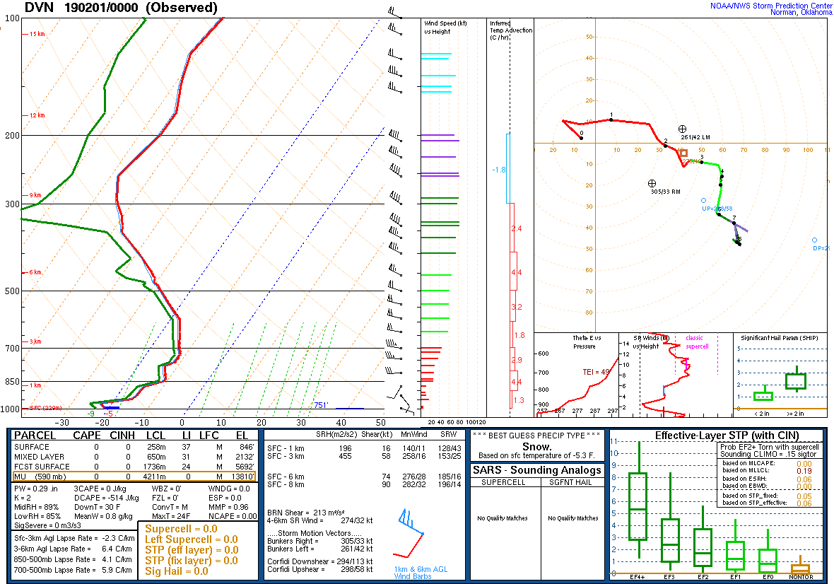
| 6 PM Jan 31, 2019 Davenport Sounding | |
 |
 |
Media use of NWS Web News Stories is encouraged! Please acknowledge the NWS as the source of any news information accessed from this site. |
|