|
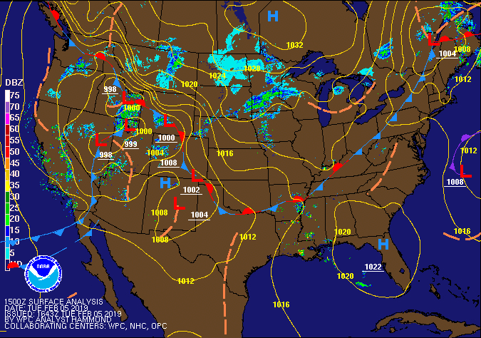
PRELIMINARY LOCAL STORM REPORT...SUMMARY
NATIONAL WEATHER SERVICE QUAD CITIES IA IL
645 AM CST WED FEB 6 2019
...RESENT WITH RANKED SUMMARY LIST AT THE BOTTOM...
..TIME... ...EVENT... ...CITY LOCATION... ...LAT.LON...
..DATE... ....MAG.... ..COUNTY LOCATION..ST.. ...SOURCE....
..REMARKS..
1136 PM SLEET PARK VIEW 41.69N 90.54W
02/05/2019 M0.7 INCH SCOTT IA NWS EMPLOYEE
0628 PM SLEET 1 SSW ELDRIDGE 41.64N 90.59W
02/05/2019 M0.6 INCH SCOTT IA NWS EMPLOYEE
CORRECTS EVENT TYPE AND LOCATION. HAIL AND
SLEET TOTAL IS 0.6 INCHES.
0407 PM SLEET 1 ENE MONTPELIER 41.47N 90.78W
02/05/2019 E0.6 INCH SCOTT IA TRAINED SPOTTER
LIGHTNING, PEA SIZE HAIL AND ABOUT 1/2 INCH
OF SLEET FROM A THUNDERSTORM.
0629 PM SLEET 1 SSW CORDOVA 41.67N 90.33W
02/05/2019 M0.5 INCH ROCK ISLAND IL TRAINED SPOTTER
0818 PM SLEET FREEPORT 42.29N 89.64W
02/05/2019 M0.3 INCH STEPHENSON IL PUBLIC
REPORT VIA SOCIAL MEDIA: SLEET ACCUMULATION
BETWEEN 1/4 AND 1/2 INCH DEEP.
0355 PM SLEET 2 NNW OAKLAND MILLS 40.97N 91.63W
02/05/2019 M0.3 INCH HENRY IA TRAINED SPOTTER
SEVERAL EPISODES OF SLEET BETWEEN 1:40 AND
3:43 PM. IT IS NOW DRIZZLING.
1106 PM SLEET MILLEDGEVILLE 41.97N 89.78W
02/05/2019 M0.2 INCH CARROLL IL TRAINED SPOTTER
0418 PM SLEET GALENA 42.42N 90.43W
02/05/2019 E0.1 INCH JO DAVIESS IL TRAINED SPOTTER
TRAINED SPOTTER DRIVING ON HWY 20 TOWARD
GALENA REPORTING THAT ROADWAY IS ICE
COVERED.
1210 AM ICE STORM 2 S MC CONNELL 42.40N 89.74W
02/06/2019 STEPHENSON IL PUBLIC
COMBINED SLEET AND FREEZING RAIN OF 0.5 TO
0.6 INCH.
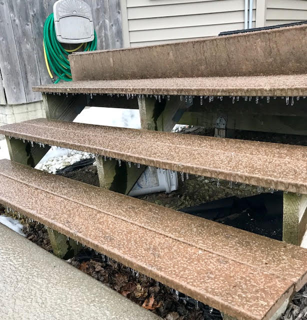
0953 PM ICE STORM DAVENPORT AIRPORT 41.61N 90.58W
02/05/2019 SCOTT IA OFFICIAL NWS OBS
0.3 INCH MEASURED ON TWIGS/TREE BRANCHES.
0842 PM ICE STORM 1 ENE NEW WINDSOR 41.20N 90.44W
02/05/2019 HENRY IL TRAINED SPOTTER
ICE ACCUMULATION 0.2 INCHES WITH OCCASIONAL
DRIZZLE NOW.
0828 PM ICE STORM 1 WNW BETTENDORF 41.57N 90.49W
02/05/2019 SCOTT IA TRAINED SPOTTER
ICE ACCUMULATION 0.2 INCHES. ICE IS MELTING.
0745 PM ICE STORM DAVENPORT MUNICIPALITY 41.62N 90.58W
02/05/2019 SCOTT IA OFFICIAL NWS OBS
CORRECTS PREVIOUS ICE STORM REPORT FROM
DAVENPORT MUNICIPALITY. MEASURED 0.2 INCH OF
ICE OFF ELEVATED SURFACES AT 745 PM.
0630 PM ICE STORM 1 SW CORDOVA 41.67N 90.33W
02/05/2019 ROCK ISLAND IL TRAINED SPOTTER
0.1 INCH OF ICE ACCUMULATION FROM FREEZING
RAIN.
0501 PM HAIL GREEN RIVER 41.48N 90.34W
02/05/2019 E0.25 INCH HENRY IL EMERGENCY MNGR
HAIL WAS MIXED WITH SLEET.
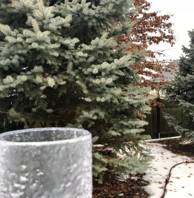
1135 PM FREEZING RAIN PARK VIEW 41.69N 90.54W
02/05/2019 M0.30 INCH SCOTT IA NWS EMPLOYEE
0947 PM FREEZING RAIN 1 NE LE CLAIRE 41.60N 90.36W
02/05/2019 E0.25 INCH SCOTT IA TRAINED SPOTTER
MEASURED ON TREE BRANCH/TWIG.
1105 PM FREEZING RAIN MILLEDGEVILLE 41.97N 89.78W
02/05/2019 M0.12 INCH CARROLL IL TRAINED SPOTTER
0411 PM FREEZING RAIN PARNELL 41.59N 92.01W
02/05/2019 M0.12 INCH IOWA IA TRAINED SPOTTER
SLEET AND FREEZING RAIN.
0900 PM FREEZING RAIN 2 NE COLUSA 40.59N 91.15W
02/05/2019 M0.10 INCH HANCOCK IL TRAINED SPOTTER
ICE ACCUMULATING ON BRANCHES,RECEIVING
FREEZING RAIN WITH SECONDARY ROADS ICE
COVERED. ILLINOIS STATE HWY 9 HERE PATCHY
ICE COVERED WITH HWY CREW SALTING ROAD ,
TEMP @ 9:00 PM TONIGHT WAS 30 DEGREES F.
0105 PM FREEZING RAIN 1 NE UNIVERSITY HEIGHTS 41.66N 91.55W
02/05/2019 E0.01 INCH JOHNSON IA TRAINED SPOTTER
SLEET FALLING ON UI CAMPUS, IOWA CITY, IA.
&&
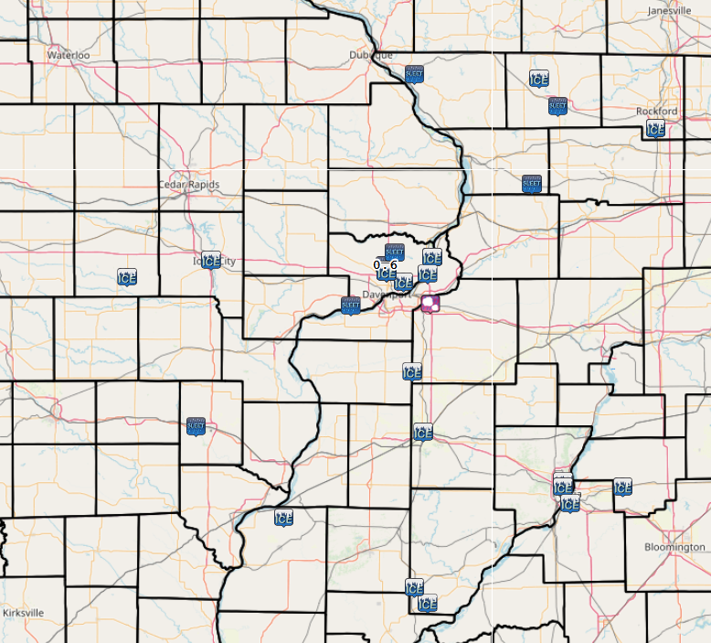
THE REPORTS BELOW ARE SEPARATED INTO SNOW...AND ICE AND SLEET
CATEGORIES...THEN BY AMOUNT...AND ARE NOT NECESSARILY THE
FINAL AMOUNT FOR EACH LOCATION.
SLEET AND FREEZING RAIN REPORTS LISTED BY AMOUNT
INCHES LOCATION ST COUNTY TIME
------ ----------------------- -- -------------- -------
0.7 PARK VIEW IA SCOTT 1136 PM
0.6 1 ENE MONTPELIER IA SCOTT 0407 PM
0.6 1 SSW ELDRIDGE IA SCOTT 0628 PM
0.5 1 SSW CORDOVA IL ROCK ISLAND 0629 PM
0.3 PARK VIEW IA SCOTT 1135 PM
0.3 2 NNW OAKLAND MILLS IA HENRY 0355 PM
0.3 FREEPORT IL STEPHENSON 0818 PM
0.2 1 NE LE CLAIRE IA SCOTT 0947 PM
0.2 MILLEDGEVILLE IL CARROLL 1106 PM
0.1 PARNELL IA IOWA 0411 PM
0.1 MILLEDGEVILLE IL CARROLL 1105 PM
0.1 2 NE COLUSA IL HANCOCK 0900 PM
0.1 GALENA IL JO DAVIESS 0418 PM
0.0 1 NE UNIVERSITY HEIGHTS IA JOHNSON 0105 PM
$$
|