Tropical system in the Gulf expected to gradually strengthen the next couple of days off the Florida Panhandle and Alabama coasts. Instances of flash flooding will be possible through Thursday along the eastern and central Gulf Coast. Severe thunderstorms will develop and move along a cold front crossing the Upper Midwest, and through the Ohio Valley/Mid-Atlantic on Tuesday. Read More >
|
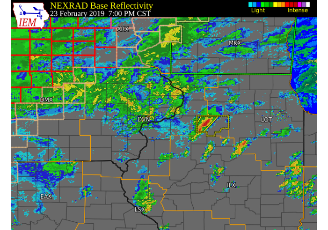
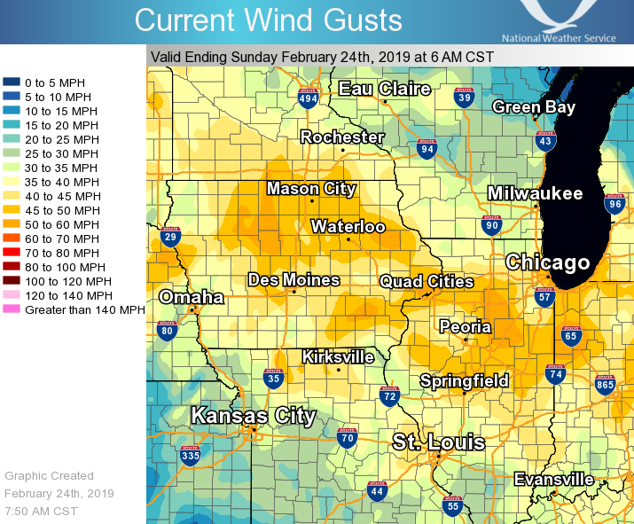
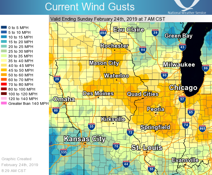
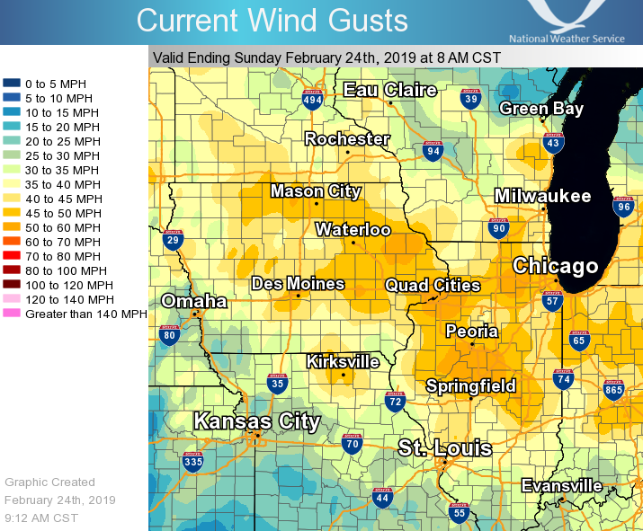
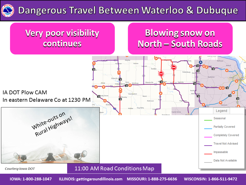
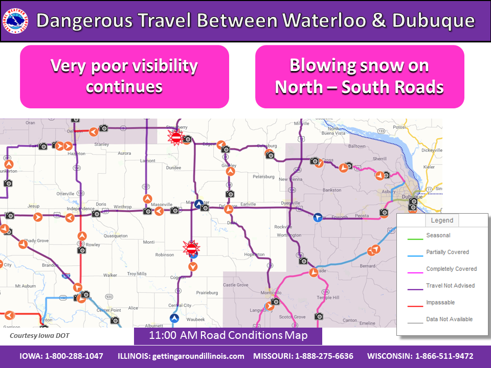
A wintry mix of snow, sleet, and freezing rain spread northeastward across the area during the early morning hours of Saturday, Feb. 23. The mixed precipitation changed to all freezing rain with ice accumulations of a glaze of ice to two tenths of an inch, mainly north of Highway 30. By late morning, temperatures warmed above freezing with the precipitation becoming all rain. Widespread rainfall amounts over three quarters of an inch were common, which resulted in some quick rises on area creeks, steams, and tributary rivers. As the system pulled away from the area late Saturday evening and early Sunday morning, strong northwest winds ushered colder air into the area and the rain changed back to a wintry mix and snow. Winds remained very strong through much of the day Sunday (Feb. 24), with peak wind gusts of 45 to 60 miles an hour common. Snowfall totals of a dusting up to a half inch were seen along and north of I 80. Snowfall accumulation just to the northwest of area caused significant blowing and drifting over Buchanan and Delware counties in Iowa closing roads and creating hazardous travel Sunday morning and afternoon. |
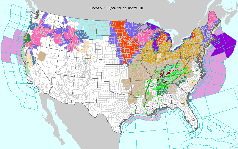 Watch, Warning, Advisory Map 11:55 pm 02/23/19 |
Wind
| RTMA Wind Gust 6 AM 02/24/19 | RTMA Wind Gust 7 AM 02/24/19 | RTMA Wind Gust 8 AM 02/24/19 |
 |
 |
 |
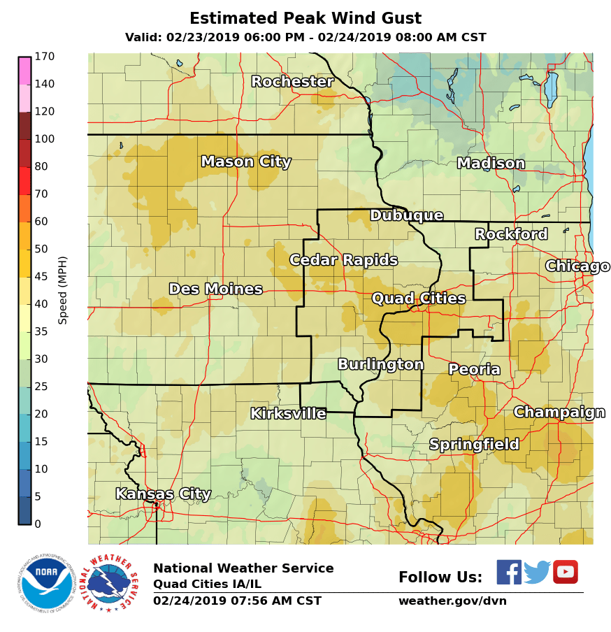
| Estimated Peak Wind RTMA Analysis 02/24/19 | Peak Wind Gusts 2/24/2019 |
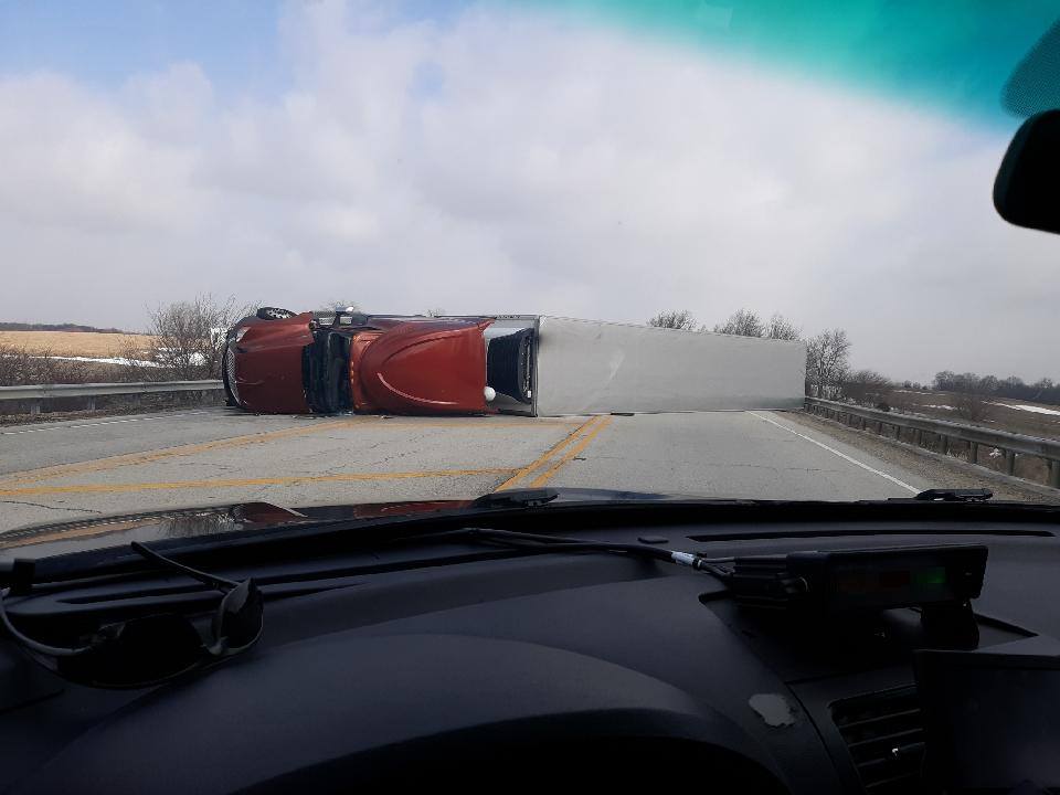
Semi blown over on IL Hwy 34 near Black Hawk East College (Photo: Henry County Sheriff Office) |
 |
 |
 |
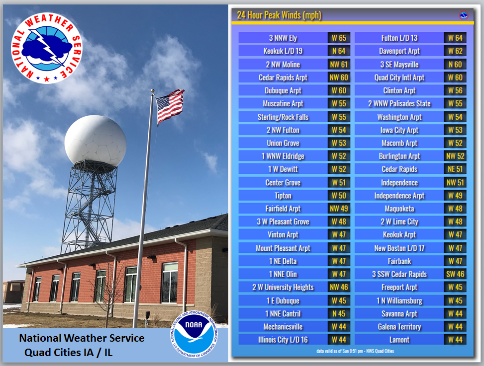
PUBLIC INFORMATION STATEMENT NATIONAL WEATHER SERVICE QUAD CITIES IA IL 1009 AM CST SUN FEB 24 2019 ...HIGHEST WIND GUSTS PAST 12 HOURS... OBSERVATIONS ARE COLLECTED FROM A VARIETY OF SOURCES WITH VARYING EQUIPMENT AND EXPOSURES. WE THANK ALL VOLUNTEER WEATHER OBSERVERS FOR THEIR DEDICATION. NOT ALL DATA LISTED ARE CONSIDERED OFFICIAL. LOCATION SPEED TIME/DATE LAT/LON DAVENPORT ARPT 62 MPH 0757 AM 02/24 41.61N/90.59W 2 NW MOLINE 61 MPH 0840 AM 02/24 41.52N/90.51W CEDAR RAPIDS ARPT 60 MPH 0711 AM 02/24 41.88N/91.71W 3 SE MAYSVILLE 60 MPH 0801 AM 02/24 41.60N/90.68W QUAD CITY INTL ARPT 59 MPH 0908 AM 02/24 41.45N/90.51W CLINTON ARPT 56 MPH 0735 AM 02/24 41.83N/90.33W DUBUQUE ARPT 56 MPH 0806 AM 02/24 42.40N/90.71W FULTON L/D 13 56 MPH 0800 AM 02/24 41.92N/90.15W MUSCATINE ARPT 55 MPH 0655 AM 02/24 41.37N/91.15W STERLING/ROCK FALLS ARPT 55 MPH 0818 AM 02/24 41.74N/89.67W 2 NW FULTON 54 MPH 0816 AM 02/24 41.89N/90.19W WASHINGTON ARPT 54 MPH 0255 AM 02/24 41.28N/91.67W IOWA CITY ARPT 53 MPH 0612 AM 02/24 41.64N/91.55W UNION GROVE 53 MPH 0815 AM 02/24 41.84N/90.04W BURLINGTON ARPT 52 MPH 0919 AM 02/24 40.78N/91.13W 1 WNW ELDRIDGE 52 MPH 0732 AM 02/24 41.65N/90.59W MACOMB ARPT 52 MPH 0555 AM 02/24 40.52N/90.65W 2 WNW PALISADES STATE PARK 52 MPH 0810 AM 02/24 41.93N/91.55W 1 W DEWITT 52 MPH 0746 AM 02/24 41.83N/90.57W INDEPENDENCE 51 MPH 0947 AM 02/24 42.47N/91.88W CEDAR RAPIDS 51 MPH 0740 AM 02/24 41.98N/91.67W FAIRFIELD ARPT 49 MPH 0855 AM 02/24 41.05N/91.98W INDEPENDENCE ARPT 49 MPH 0555 AM 02/24 42.45N/91.95W 3 W PLEASANT GROVE 48 MPH 0902 AM 02/24 40.97N/91.34W MAQUOKETA 48 MPH 0733 AM 02/24 42.07N/90.68W 2 W LIME CITY 48 MPH 0720 AM 02/24 41.65N/91.13W KEOKUK ARPT 47 MPH 0555 AM 02/24 40.46N/91.43W FAIRBANK 47 MPH 0616 AM 02/24 42.64N/92.05W MOUNT PLEASANT ARPT 47 MPH 0655 AM 02/24 40.95N/91.51W NEW BOSTON L/D 17 47 MPH 0910 AM 02/24 41.18N/91.05W 1 NE DELTA 47 MPH 0730 AM 02/24 41.34N/92.31W VINTON ARPT 47 MPH 0455 AM 02/24 42.23N/92.03W 3 SSW CEDAR RAPIDS 46 MPH 0320 AM 02/24 41.93N/91.68W 2 W UNIVERSITY HEIGHTS 46 MPH 0152 AM 02/24 41.66N/91.60W 1 NNE OLIN 45 MPH 0725 AM 02/24 42.02N/91.13W 1 NNE CANTRIL 45 MPH 1240 AM 02/24 40.66N/92.06W 1 N WILLIAMSBURG 45 MPH 0740 AM 02/24 41.69N/92.01W LAMONT 44 MPH 0900 AM 02/24 42.60N/91.64W SAVANNA ARPT 44 MPH 0638 AM 02/24 42.05N/90.11W MECHANICSVILLE 44 MPH 0605 AM 02/24 41.90N/91.26W URBANA 43 MPH 0929 AM 02/24 42.22N/91.88W UNIONVILLE 43 MPH 0951 AM 02/24 41.82N/89.98W WILLIAMSBURG 43 MPH 0729 AM 02/24 41.66N/92.00W FREEPORT ARPT 43 MPH 0915 AM 02/24 42.25N/89.58W FORT MADISON ARPT 43 MPH 0215 AM 02/24 40.66N/91.33W 1 ENE MARION 42 MPH 0220 AM 02/24 42.05N/91.57W ROWLEY 42 MPH 0815 AM 02/24 42.37N/91.84W 1 E BRANDON 42 MPH 0933 AM 02/24 42.31N/91.98W QUASQUETON 41 MPH 0746 AM 02/24 42.39N/91.76W LE CLAIRE L/D 14 41 MPH 0930 AM 02/24 41.58N/90.42W ROCK ISLAND L/D 15 41 MPH 0810 AM 02/24 41.52N/90.57W STRONGHURST 40 MPH 0852 AM 02/24 40.74N/90.91W 1 NNW PRINCETON 40 MPH 0847 AM 02/24 41.40N/89.47W |
||
River Flooding
Hydrographs
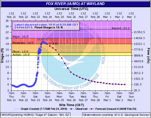
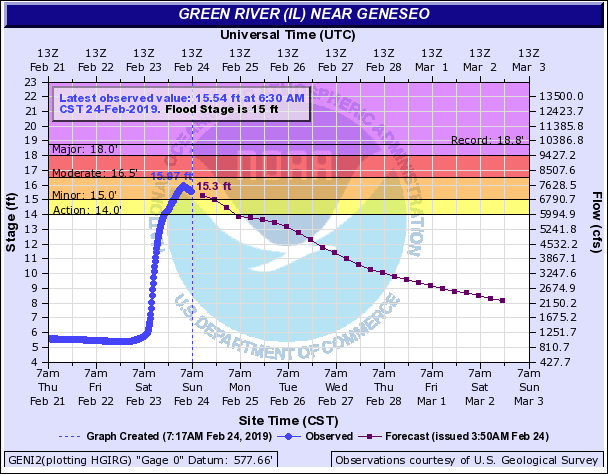
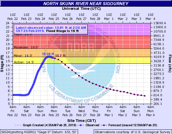
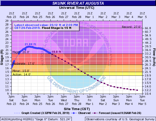
| Fox River at Wayland | Green River Near Geneseo | North Skunk River Near Sigourney | Skunk River at Augusta |
 |
 |
 |
 |
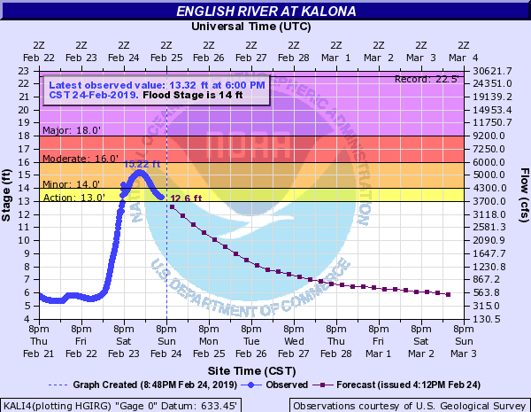
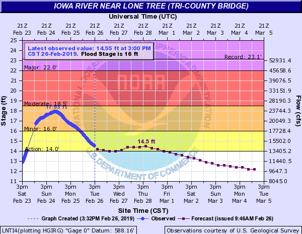
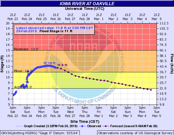
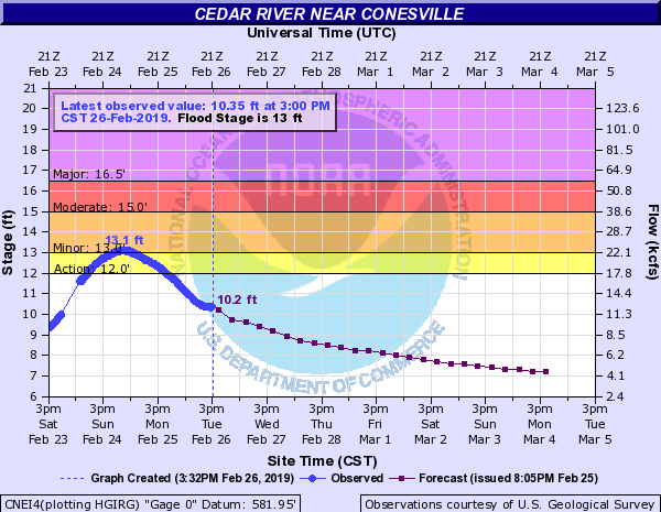
| English River at Kalona | Iowa River near Lone Tree | Iowa River at Oakville | Cedar River near Conesville |
 |
 |
 |
 |
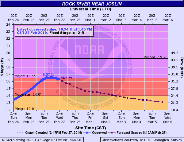
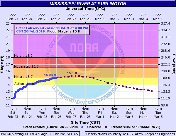
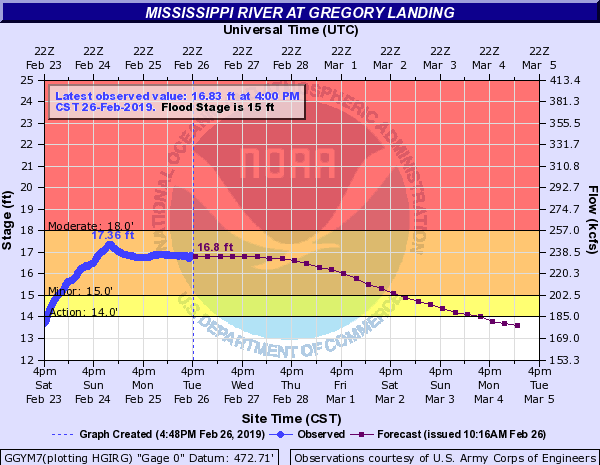
| Wapsipinicon River near De Witt | Rock River Near Joslin, IL | Mississippi River at Burlington | Mississippi River at Gregory Landing |
.png) |
 |
 |
 |
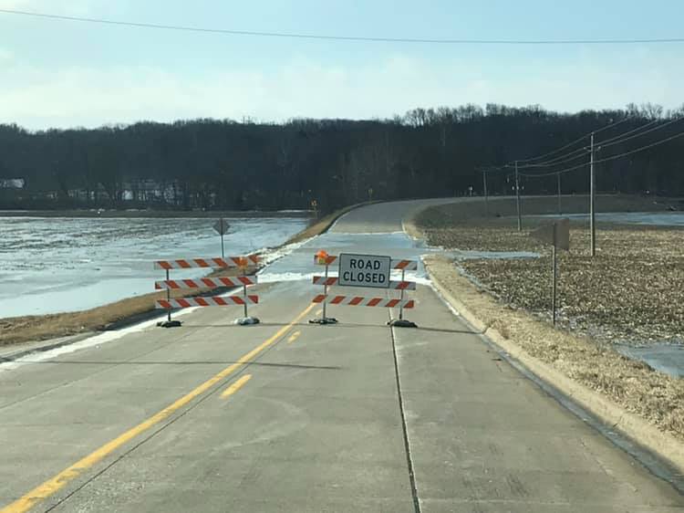
| Bridgeport Rd near Skunk River (Courtesy Des Moines County Sheriff) | |||
 |
Snowfall / Ice Accumulation
| Snowfall accumulation just to the northwest of area caused significant blowing and drifting over Buchanan and Delware counties in Iowa closing roads and creating hazardous travel. | ||
 |
 |
|
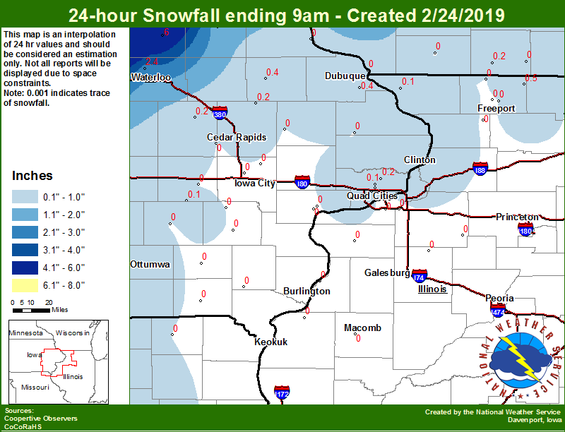
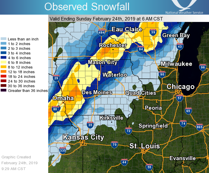
| 02/24/19 Snowfall Ending 9 am | Regional Snowfall | LSR Snowfall Analysis (IEM) |
 |
 |
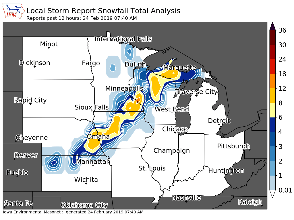 |
24 hour snow fall in inches, for eastern Iowa, northwest and west central Illinois, and northeast Missouri. Reported between Midnight and 9 AM, Sunday February 24, 2019. ....IOWA.... Tripoli 0 N 6.0 Boone 1 SSW 4.7 Ames US 30 2 SSE 4.5 NWS Johnston* 5 NNW 2.6 Waterloo ASOS 5 NW 2.4 Fayette 1 NW 1.5 Toledo 3 N 1.0 Beaconsfield 1 NNE 0.5 Allerton 2 S 0.5 Dubuque Arpt 7 SW 0.4 Manchester 0.4 Park View 0.2 WSW 0.2 Vinton 0.2 Coggon 0.2 Davenport Arpt 5 N 0.1 North English 0.1 Eldridge 0.7 SSW 0.1 Davenport 3.8 NNW 0.1 Salem 1S 0.0 Anamosa 3 SSW 0.0 Bettendorf 2.2 SE 0.0 Washington 0.0 Davenport 0.9 WNW 0.0 Davenport 0.9 SSW 0.0 Wellman 4.0 E 0.0 North Liberty 0.7 SSW 0.0 Guttenberg Dam 10 0.0 Newton 1 NE 0.0 Fairfield 0.0 Fairfax 4.0 NW 0.0 Keosauqua 0.0 Muscatine 2.1 N 0.0 Sigourney 0.0 Williamsburg 0.0 Maquoketa 4 W 0.0 Muscatine 2N 0.0 Dubuque LD11 0.0 Solon 0.3 ESE 0.0 ....ILLINOIS.... Davis 0.5 N 0.5 Galena 0.1 Roscoe 2SE 0.1 Quad City Arpt 3 S 0.0 Freeport 0.0 Ogden 0.0 Freeport 2.0 NW 0.0 Coal Valley 2.6 E 0.0 Winslow 4.3 ESE 0.0 Altona 0.0 Aledo 0.0 Windsor 0.0 Rockford ASOS 0.0 Romeoville 0.0 Paw Paw 1 E 0.0 Gladstone LD18 0.0 Princeton 1.1 SE 0.0 Steward 0.0 Princeton 0.0 Kewanee 1 E 0.0 Colchester 3.5 NE 0.0 Dallas City 3.0 SSE 0.0 Mundelein 0.0 Shannon 0.2 S 0.0 Tuscola 0.0 Rochelle 0.0 ....MISSOURI.... Memphis 0.0 Columbia 0.0 ....WISCONSIN.... Steuben 4SE 3 NE 3.0 La Crosse WFO 2.3 Viroqua 2.2 Monroe 1 W 0.2 Madison-ASOS 0.2 Brodhead 1 SW 0.0 Whitewater 0.0 Delavan-1 W-WWTP 1 W 0.0 Darlington 0.0 Beloit-College 0.0 |
||
| (Local Storm Reports Map From 6 pm 2/22 to Noon 2/24) |
 |
PRELIMINARY LOCAL STORM REPORT...SUMMARY
NATIONAL WEATHER SERVICE QUAD CITIES IA IL
1004 AM CST SUN FEB 24 2019

..TIME...   ...EVENT...      ...CITY LOCATION...     ...LAT.LON...
..DATE...   ....MAG....      ..COUNTY LOCATION..ST.. ...SOURCE....
            ..REMARKS..

0917 AM     NON-TSTM WND GST 1 ESE INDEPENDENCE      42.47N 91.88W
02/24/2019  M51 MPH          BUCHANAN           IA   MESONET

            MESONET STATION E8796, INDEPENDENCE.

0831 AM     SNOW             3 N STOCKTON            42.40N 90.00W
02/24/2019  E0.3 INCH        JO DAVIESS         IL   CO-OP OBSERVER


0826 AM     NON-TSTM WND GST MOLINE QUAD-CITY AIRPOR 41.45N 90.51W
02/24/2019  M59 MPH          ROCK ISLAND        IL   ASOS


0821 AM     HEAVY RAIN       3 ENE CHARLIE HEATH MEM 40.61N 91.84W
02/24/2019  M1.30 INCH       CLARK              MO   TRAINED SPOTTER

            STORM TOTAL, 48-HR TOTAL.

0818 AM     NON-TSTM WND GST 1 SE WHITESIDE COUNTY A 41.74N 89.67W
02/24/2019  M55 MPH          WHITESIDE          IL   AWOS

            AWOS STATION SQI, STERLING/ROCK FALLS ARPT.

0816 AM     NON-TSTM WND GST 4 NE CLINTON            41.89N 90.19W
02/24/2019  M54 MPH          CLINTON            IA   MESONET

            MESONET STATION AV270, 2 NW FULTON.

0813 AM     SNOW             2 NNE CEDAR RAPIDS      42.01N 91.66W
02/24/2019  E0.2 INCH        LINN               IA   TRAINED SPOTTER

            LIGHT DUSTING, ALL BLEW AWAY DUE TO WIND.

0806 AM     NON-TSTM WND GST DUBUQUE REGIONAL ARPT   42.40N 90.71W
02/24/2019  M56 MPH          DUBUQUE            IA   ASOS

            ASOS STATION DBQ, DUBUQUE ARPT.

0802 AM     HEAVY RAIN       2 SSE SCHAPVILLE        42.37N 90.19W
02/24/2019  M1.79 INCH       JO DAVIESS         IL   TRAINED SPOTTER

            PAST 48 HOURS.

0800 AM     NON-TSTM WND GST 4 N FULTON              41.92N 90.15W
02/24/2019  M56 MPH          WHITESIDE          IL   MESONET

            MESONET STATION FLTI2, FULTON L/D 13.

0800 AM     HEAVY RAIN       2 NNW MUSCATINE         41.44N 91.08W
02/24/2019  M1.41 INCH       MUSCATINE          IA   TRAINED SPOTTER

            48-HR TOTAL, STORM TOTAL.

0758 AM     SNOW             LOWDEN                  41.86N 90.92W
02/24/2019  E0.3 INCH        CEDAR              IA   CO-OP OBSERVER

            HARD TO MEASURE DUE TO WIND, SNOW SINCE
            MIDNIGHT.

0757 AM     NON-TSTM WND GST DAVENPORT AIRPORT       41.61N 90.59W
02/24/2019  M62 MPH          SCOTT              IA   ASOS

            ASOS STATION DVN, DAVENPORT ARPT.

0740 AM     NON-TSTM WND GST CEDAR RAPIDS            41.98N 91.67W
02/24/2019  M51 MPH          LINN               IA   MESONET

            MESONET STATION RCDI4, CEDAR RAPIDS.

0711 AM     NON-TSTM WND GST CEDAR RAPIDS MUNICIPALI 41.88N 91.71W
02/24/2019  M60 MPH          LINN               IA   ASOS

            ASOS STATION CID, CEDAR RAPIDS ARPT.

0700 AM     SNOW             DAVIS                   42.43N 89.42W
02/24/2019  M0.5 INCH        STEPHENSON         IL   COCORAHS

            COCORAHS STATION IL-SP-7, DAVIS.

0700 AM     SNOW             1 SSE MANCHESTER        42.47N 91.45W
02/24/2019  M0.4 INCH        DELAWARE           IA   CO-OP OBSERVER

            CO-OP OBSERVER STATION MHRI4, MANCHESTER.

0700 AM     SNOW             GALENA                  42.42N 90.43W
02/24/2019  M0.1 INCH        JO DAVIESS         IL   CO-OP OBSERVER

            CO-OP OBSERVER STATION GPBI2, GALENA.

0655 AM     NON-TSTM WND GST MUSCATINE MUNICIPALITY  41.37N 91.15W
02/24/2019  M55 MPH          MUSCATINE          IA   AWOS

            AWOS STATION MUT, MUSCATINE ARPT.

0646 AM     NON-TSTM WND GST 1 NW ELDRIDGE           41.65N 90.59W
02/24/2019  M50 MPH          SCOTT              IA   MESONET

            MESONET STATION D9509, 1 WNW ELDRIDGE.

0630 AM     NON-TSTM WND GST 3 NNW MOLINE            41.52N 90.51W
02/24/2019  M53 MPH          ROCK ISLAND        IL   MESONET

            MESONET STATION IA061, 2 NW MOLINE.

0619 AM     SNOW             DUBUQUE REGIONAL ARPT   42.41N 90.73W
02/24/2019  M0.4 INCH        DUBUQUE            IA   OFFICIAL NWS OBS

            SNOWFALL SINCE 6 AM. HARD TO MEASURE DUE TO
            HIGH WIND.

0612 AM     NON-TSTM WND GST IOWA CITY MUNICIPALITY  41.64N 91.55W
02/24/2019  M53 MPH          JOHNSON            IA   ASOS

            ASOS STATION IOW, IOWA CITY ARPT.

0600 AM     SNOW             COGGON                  42.28N 91.53W
02/24/2019  M0.2 INCH        LINN               IA   CO-OP OBSERVER

            CO-OP OBSERVER STATION CGGI4, COGGON.

0555 AM     NON-TSTM WND GST MACOMB MUNICIPAL ARPT   40.52N 90.65W
02/24/2019  M52 MPH          MCDONOUGH          IL   AWOS

            AWOS STATION MQB, MACOMB ARPT.

0534 AM     NON-TSTM WND GST 1 WNW DEWITT            41.83N 90.57W
02/24/2019  M50 MPH          CLINTON            IA   MESONET

            MESONET STATION RDWI4, 1 W DEWITT.

0530 AM     NON-TSTM WND GST 4 SSE MAYSVILLE         41.60N 90.68W
02/24/2019  M52 MPH          SCOTT              IA   MESONET

            MESONET STATION RDVI4, 3 SE MAYSVILLE.

0413 AM     NON-TSTM WND GST CLINTON MUNICIPALITY    41.83N 90.33W
02/24/2019  M52 MPH          CLINTON            IA   AWOS

            AWOS STATION CWI, CLINTON ARPT.

0342 AM     NON-TSTM WND GST 1 SSW DAVENPORT MUNICIP 41.61N 90.59W
02/24/2019  M51 MPH          SCOTT              IA   ASOS

            ASOS STATION DVN, DAVENPORT ARPT.

0330 AM     NON-TSTM WND GST 2 SSW BERTRAM           41.93N 91.55W
02/24/2019  M52 MPH          LINN               IA   MESONET

            MESONET STATION RCRI4, 2 WNW PALISADES STATE
            PARK.

0317 AM     NON-TSTM WND GST 1 ESE INDEPENDENCE      42.47N 91.88W
02/24/2019  M50 MPH          BUCHANAN           IA   MESONET

            MESONET STATION E8796, INDEPENDENCE.

0255 AM     NON-TSTM WND GST 1 SW WASHINGTON AIRPORT 41.28N 91.67W
02/24/2019  M54 MPH          WASHINGTON         IA   AWOS

            AWOS STATION AWG, WASHINGTON ARPT.

0241 AM     NON-TSTM WND GST IOWA CITY MUNICIPALITY  41.64N 91.55W
02/24/2019  M53 MPH          JOHNSON            IA   ASOS

            ASOS STATION IOW, IOWA CITY ARPT.

0236 AM     NON-TSTM WND GST CEDAR RAPIDS MUNICIPALI 41.88N 91.71W
02/24/2019  M54 MPH          LINN               IA   ASOS

            ASOS STATION CID, CEDAR RAPIDS ARPT.

1203 AM     HEAVY RAIN       2 W CEDAR RAPIDS        41.98N 91.71W
02/24/2019  M1.42 INCH       LINN               IA   TRAINED SPOTTER

            STORM TOTAL.

1136 PM     HEAVY RAIN       CANTRIL                 40.65N 92.07W
02/23/2019  M1.65 INCH       VAN BUREN          IA   TRAINED SPOTTER

            STORM TOTAL.

1136 PM     HEAVY RAIN       4 N STOCKTON            42.41N 90.00W
02/23/2019  M1.41 INCH       JO DAVIESS         IL   CO-OP OBSERVER

            STORM TOTAL SO FAR.
|
Rain Reports
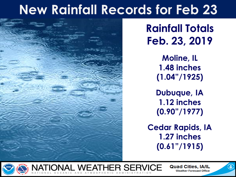 |
Feb. 23, 2019 Rainfall Records: |
|
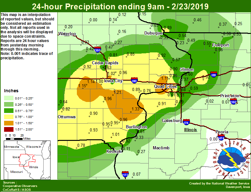
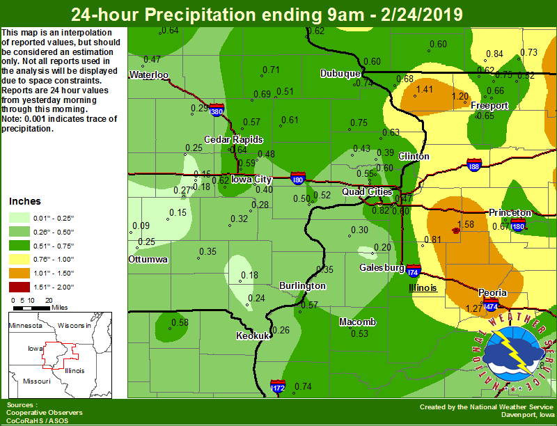
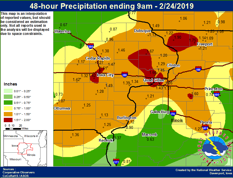
| 02/23/19 Rainfall Map Ending 9 am | 02/24/19 Rainfall Map Ending 9 am | 48-hr Local Rainfall |
 |
 |
 |
| 24-Hr Rainfall Reports Ending 9 am 02/23/19 | 24-Hr Rainfall Reports Ending 9 am 02/24/19 | 48-Hr Rainfall Reports Ending 9 am 02/24/19 |
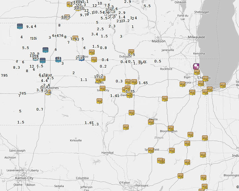
....IOWA.... Morning Sun 1.7 E 1.33 Davenport 0.9 SSW 1.31 Allerton 2 S 1.30 Bettendorf 2.2 SE 1.28 Riverdale 0.5 N 1.27 Ainsworth 7.4 N 1.21 Davenport 3.8 NNW 1.19 North English 1.15 Parnell 0.1 SSW 1.14 Eldridge 0.7 SSW 1.11 Beaconsfield 1 NNE 1.03 Coralville 1.3 SE 1.03 North Liberty 0.7 SSW 1.02 Donnellson 1.01 Kalona 7.3 NNW 1.00 Solon 0.3 ESE 0.99 Davenport 0.9 WNW 0.97 Washington 0.96 Iowa City 8.0 NE 0.96 New London 1.5 SW 0.96 Salem 1S 0.95 Centerville 0 NE 0.95 Salem 3.1 ESE 0.95 Keosauqua 0.93 Marengo 3.6 N 0.92 Maquoketa 4 W 0.92 De Witt 0.90 Fairfield 0.90 Fairfax 4.0 NW 0.90 Muscatine 2.1 N 0.89 Dubuque LD11 0.89 Anamosa 3 SSW 0.85 Park View 0.2 WSW 0.85 Muscatine 2N 0.82 Davenport Arpt 5 N 0.82 Ottumwa ASOS 6 NNW 0.82 Marion 1.7 NNW 0.81 Cedar Rapids 2.7 NE 0.74 Oskaloosa AWOS 9 ESE 0.64 Cedar Rapids Arpt 5 SW 0.63 Burlington Arpt 2 SW 0.61 Camanche 1.2 W 0.60 Iowa City Arpt 0.57 Charlotte 1.9 WNW 0.57 Central City 6.7 W 0.47 Vinton 0.42 Dubuque Arpt 7 SW 0.39 Pella AWOS 2 WSW 0.38 Newton 1 NE 0.38 Grinnell AWOS 2 SSW 0.38 Le Claire 1.8 NNE 0.37 Center Point 0.6 NNW 0.29 Coggon 0.27 Marshalltown 1 NW 0.24 Bellevue LD12 0.23 Mason City 1 NNE 0.23 Waterloo ASOS 5 NW 0.20 NWS Johnston* 5 NNW 0.19 Mason City ASOS 6 W 0.17 Manchester 0.16 Guttenberg Dam 10 0.15 Strawberry Point 0.14 Elkader 6SSW 0.12 Fayette 1 NW 0.12 Keokuk LD19 0.11 Marshalltown ASOS 4 N 0.11 Hampton 1 N 0.09 Ames US 30 2 SSE 0.07 Rickardsville 0.2 W 0.03 Boone 1 SSW 0.03 Mount Auburn 2.2 NNW 0.03 Perry 0 W 0.02 Oelwein AWOS 0.00 ....ILLINOIS.... Prophetstown 0.2 SW 0.92 Nauvoo 0.7 SSE 0.92 Aledo 0.91 Coal Valley 1.9 SE 0.91 New Windsor 2.0 N 0.89 Ill. City LD16 3 WNW 0.76 Freeport 2.9 WSW 0.63 Quad City Arpt 3 S 0.61 Geneseo 2.0 NW 0.59 Coal Valley 2.6 E 0.58 Shannon 0.2 S 0.56 Pearl City 0.4 SW 0.55 Galena 0.54 Davis 0.5 N 0.53 Freeport 0.53 Dakota 4.8 NW 0.50 Elizabeth 0.49 Freeport 2.0 NW 0.48 Dallas City 3.0 SSE 0.33 Bentley 0.27 Steward 0.15 Colchester 3.5 NE 0.10 Tiskilwa 2.1 N 0.07 Quincy ASOS 0.07 Macomb 0.06 Mendota 2 SE 0.05 Quincy Dam 21 0.04 Princeton 1.1 SE 0.03 Princeton 0.03 Kewanee 1 E 0.02 Roscoe 2SE 0.01 Rockford ASOS 0.00 Ottawa 4 SW 0.00 Mundelein 0.00 Decatur Airport 0.00 Jacksonville AWOS 0.00 Romeoville 0.00 Rochelle AWOS 0.00 Paw Paw 1 E 0.00 Peoria ASOS 0.00 Joliet 0.00 St Anne 0.00 Bloomington Airport 0.00 Rochelle 0.00 Galesburg Arpt 3 SW 0.00 Lincoln NWS 0.00 ....MISSOURI.... Memphis 0.78 Chillicothe 2 NW 0.69 Kirksville ASOS 0.40 Columbia 0.03 ....WISCONSIN.... Darlington 0.46 Monroe 1 W 0.37 Brodhead 1 SW 0.25 Steuben 4SE 3 NE 0.12 La Crosse WFO 0.10 Whitewater 0.08 Prairie du Chien AWOS 0.05 Viroqua 0.03 Madison-ASOS 0.02 Beloit-College 0.00 Delavan-1 W-WWTP 1 W 0.00 Watertown-AWOS 0.00 ....MINNESOTA.... Theilman 1SSW 0.02 |
....IOWA.... Cedar Rapids 2.7 NE 0.83 Maquoketa 4 W 0.75 Dubuque Arpt 7 SW 0.74 Iowa City Arpt 0.73 Manchester 0.71 Coggon 0.69 Ames US 30 2 SSE 0.66 Boone 1 SSW 0.64 Tripoli 0 N 0.64 Cedar Rapids Arpt 5 SW 0.64 Charlotte 1.9 WNW 0.63 Guttenberg Dam 10 0.62 Kalona 7.3 NNW 0.62 Anamosa 3 SSW 0.61 Dubuque LD11 0.60 Park View 0.2 WSW 0.60 North Liberty 0.7 SSW 0.59 Marion 1.7 NNW 0.57 Davenport Arpt 5 N 0.55 Eldridge 0.7 SSW 0.55 Toledo 3 N 0.53 Muscatine 2N 0.52 Davenport 0.9 SSW 0.52 Hopkinton 5.4 WSW 0.51 Burlington Arpt 2 SW 0.51 NWS Johnston* 5 NNW 0.51 Muscatine 2.1 N 0.50 Mason City ASOS 6 W 0.49 Bettendorf 2.2 SE 0.48 Solon 0.3 ESE 0.48 Waterloo ASOS 5 NW 0.47 Fayette 1 NW 0.45 Calamus 2.0 NE 0.43 Iowa City 0.40 De Witt 0.39 Marshalltown 1 NW 0.37 Fairfax 4.0 NW 0.35 Fairfield 0.35 Davenport 3.8 NNW 0.35 Washington 0.32 Centerville 0 NE 0.30 Marshalltown ASOS 4 N 0.29 Vinton 0.29 Ainsworth 7.4 N 0.28 North English 0.27 Beaconsfield 1 NNE 0.26 Keokuk LD19 0.26 Ottumwa ASOS 6 NNW 0.25 Marengo 3.6 N 0.25 Donnellson 0.24 Salem 1S 0.18 Parnell 0.1 SSW 0.18 Allerton 2 S 0.16 Sigourney 0.15 Williamsburg 0.15 Oskaloosa AWOS 9 ESE 0.09 Newton 1 NE 0.02 ....ILLINOIS.... Paw Paw 1 E 1.65 Kewanee 1 E 1.58 Elizabeth 1.41 Rochelle 1.28 Peoria ASOS 1.27 Pearl City 0.4 SW 1.20 Rockford ASOS 1.18 Roscoe 2SE 1.11 Rochelle AWOS 1.03 Minonk 0.97 Mundelein 0.86 Quad City Arpt 3 S 0.82 Altona 0.81 Romeoville 0.79 Dakota 4.8 NW 0.75 Quincy ASOS 0.74 Galena 0.68 Tiskilwa 2.1 N 0.67 Freeport 2.0 NW 0.66 Shannon 0.2 S 0.65 Ottawa 4 SW 0.64 Princeton 1.1 SE 0.62 Princeton 0.62 Winslow 4.3 ESE 0.62 Coal Valley 1.9 SE 0.60 Dallas City 3.0 SSE 0.57 Freeport 0.56 Colchester 3.5 NE 0.53 Davis 0.5 N 0.52 Steward 0.52 Galesburg 0.50 Joliet 0.48 Coal Valley 2.6 E 0.47 Bloomington Airport 0.44 Galesburg Arpt 3 SW 0.38 Gladstone LD18 0.35 Aledo 0.30 St Anne 0.30 Lincoln NWS 0.28 Windsor 0.27 Quincy Dam 21 0.27 Alexis 1 SW 0.20 Decatur Airport 0.18 Ogden 0.09 Tuscola 0.05 ....MISSOURI.... Memphis 0.58 Kirksville ASOS 0.31 Columbia 0.17 Chillicothe 2 NW 0.13 ....WISCONSIN.... Beloit-College 1.33 Whitewater 1.03 Steuben 4SE 3 NE 0.96 Madison-ASOS 0.89 Delavan-1 W-WWTP 1 W 0.86 Watertown-AWOS 0.85 Monroe 1 W 0.84 Brodhead 1 SW 0.73 Viroqua 0.67 La Crosse WFO 0.66 Prairie du Chien AWOS 0.62 Darlington 0.60 |
....IOWA.... Davenport 0.9 SSW 1.83 Bettendorf 2.2 SE 1.76 Maquoketa 4 W 1.67 Eldridge 0.7 SSW 1.66 Kalona 7.3 NNW 1.62 North Liberty 0.7 SSW 1.61 Cedar Rapids 2.7 NE 1.57 Davenport 3.8 NNW 1.54 Dubuque LD11 1.49 Ainsworth 7.4 N 1.49 Solon 0.3 ESE 1.47 Anamosa 3 SSW 1.46 Allerton 2 S 1.46 Park View 0.2 WSW 1.45 North English 1.42 Muscatine 2.1 N 1.39 Marion 1.7 NNW 1.38 Davenport Arpt 5 N 1.37 Muscatine 2N 1.34 Parnell 0.1 SSW 1.32 Iowa City Arpt 1.30 Beaconsfield 1 NNE 1.29 De Witt 1.29 Washington 1.28 Cedar Rapids Arpt 5 SW 1.27 Centerville 0 NE 1.25 Donnellson 1.25 Fairfield 1.25 Fairfax 4.0 NW 1.25 Charlotte 1.9 WNW 1.20 Marengo 3.6 N 1.17 Salem 1S 1.13 Dubuque Arpt 7 SW 1.13 Burlington Arpt 2 SW 1.12 Ottumwa ASOS 6 NNW 1.07 Coggon 0.96 Manchester 0.87 Guttenberg Dam 10 0.77 Ames US 30 2 SSE 0.73 Oskaloosa AWOS 9 ESE 0.73 Vinton 0.71 NWS Johnston* 5 NNW 0.70 Waterloo ASOS 5 NW 0.67 Boone 1 SSW 0.67 Mason City ASOS 6 W 0.66 Marshalltown 1 NW 0.61 Fayette 1 NW 0.57 Newton 1 NE 0.40 Marshalltown ASOS 4 N 0.40 Keokuk LD19 0.37 ....ILLINOIS.... Elizabeth 1.90 Pearl City 0.4 SW 1.75 Paw Paw 1 E 1.65 Kewanee 1 E 1.60 Coal Valley 1.9 SE 1.51 Quad City Arpt 3 S 1.43 Rochelle 1.28 Peoria ASOS 1.27 Dakota 4.8 NW 1.25 Galena 1.22 Aledo 1.21 Shannon 0.2 S 1.21 Rockford ASOS 1.18 Freeport 2.0 NW 1.14 Roscoe 2SE 1.12 Freeport 1.09 Davis 0.5 N 1.05 Coal Valley 2.6 E 1.05 Rochelle AWOS 1.03 Dallas City 3.0 SSE 0.90 Mundelein 0.86 Quincy ASOS 0.81 Romeoville 0.79 Tiskilwa 2.1 N 0.74 Steward 0.67 Princeton 1.1 SE 0.65 Princeton 0.65 Ottawa 4 SW 0.64 Colchester 3.5 NE 0.63 Joliet 0.48 Bloomington Airport 0.44 Galesburg Arpt 3 SW 0.38 Quincy Dam 21 0.31 St Anne 0.30 Lincoln NWS 0.28 Decatur Airport 0.18 ....MISSOURI.... Memphis 1.36 Chillicothe 2 NW 0.82 Kirksville ASOS 0.71 Columbia 0.20 ....WISCONSIN.... Beloit-College 1.33 Monroe 1 W 1.21 Whitewater 1.11 Steuben 4SE 3 NE 1.08 Darlington 1.06 Brodhead 1 SW 0.98 Madison-ASOS 0.91 Delavan-1 W-WWTP 1 W 0.86 Watertown-AWOS 0.85 La Crosse WFO 0.76 Viroqua 0.70 Prairie du Chien AWOS 0.67 |
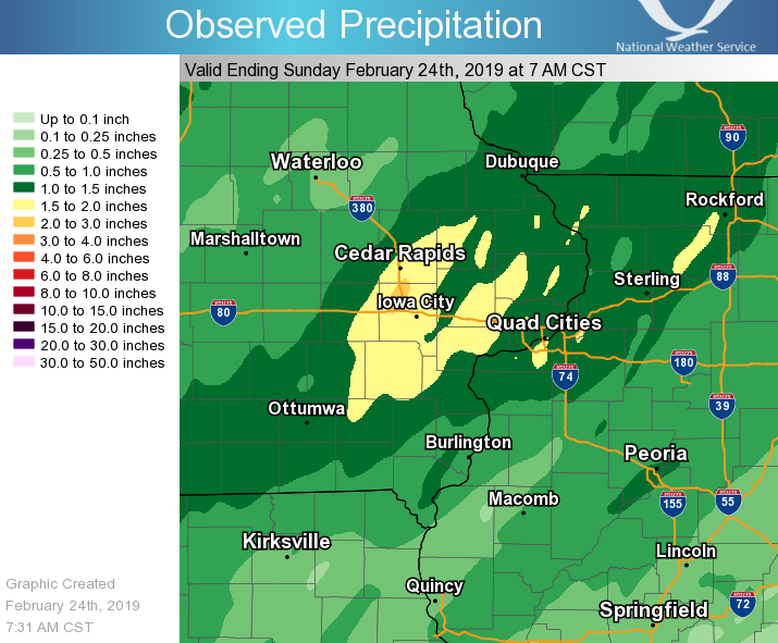
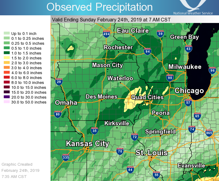
| 48-hr Local Map | 48-hr Regional Map | |
 |
 |
|
PUBLIC INFORMATION STATEMENT NATIONAL WEATHER SERVICE QUAD CITIES IA IL 853 AM CST SUN FEB 24 2019 ...48-HR RAINFALL REPORTS ABOVE 1 INCH... OBSERVATIONS ARE COLLECTED FROM A VARIETY OF SOURCES WITH VARYING EQUIPMENT AND EXPOSURES. WE THANK ALL VOLUNTEER WEATHER OBSERVERS FOR THEIR DEDICATION. NOT ALL DATA LISTED ARE CONSIDERED OFFICIAL. LOCATION AMOUNT TIME/DATE LAT/LON ELIZABETH 1.90 IN 0630 AM 02/24 42.33N/90.25W 2 SSE DAVENPORT 1.83 IN 0700 AM 02/24 41.53N/90.59W RIVERDALE 1.76 IN 0630 AM 02/24 41.54N/90.45W 3 W PLEASANT GROVE 1.74 IN 0812 AM 02/24 40.97N/91.34W 1 E MUSCATINE 1.69 IN 0840 AM 02/24 41.42N/91.05W MAQUOKETA 1.67 IN 0700 AM 02/24 42.07N/90.70W ELDRIDGE 1.66 IN 0800 AM 02/24 41.64N/90.59W 1 NNW WILLIAMSTOWN 1.62 IN 0700 AM 02/24 41.59N/91.75W NORTH LIBERTY 1.61 IN 0800 AM 02/24 41.73N/91.62W 1 E KEWANEE 1.60 IN 0700 AM 02/24 41.25N/89.90W 2 NE CEDAR RAPIDS 1.57 IN 0600 AM 02/24 42.00N/91.63W 2 NNW DAVENPORT 1.54 IN 0730 AM 02/24 41.58N/90.62W WAPSI RVR AT DEWITT 1.53 IN 0830 AM 02/24 41.77N/90.53W CLEAR CRK AT CORALVILLE 1.52 IN 0800 AM 02/24 41.68N/91.60W 1 ESE COAL VALLEY 1.51 IN 0700 AM 02/24 41.43N/90.42W CEDAR CRK NEAR OAKLAND MILLS 1.50 IN 0830 AM 02/24 40.93N/91.67W 4 N HASKINS 1.49 IN 0700 AM 02/24 41.40N/91.54W SOLON 0.3 ESE 1.47 IN 0700 AM 02/24 41.80N/91.49W 3 SSW ANAMOSA 1.46 IN 0700 AM 02/24 42.08N/91.30W 3 E IOWA CITY 1.45 IN 0841 AM 02/24 41.65N/91.48W PARK VIEW 1.45 IN 0700 AM 02/24 41.69N/90.54W IOWA RVR AT IOWA CITY 1.45 IN 0800 AM 02/24 41.66N/91.54W RAPID CRK AT IOWA CITY 1.43 IN 0800 AM 02/24 41.69N/91.49W QUAD CITY INTL ARPT 1.43 IN 0552 AM 02/24 41.45N/90.51W NORTH ENGLISH 1.42 IN 0700 AM 02/24 41.52N/92.07W ROCK ISLAND L/D 15 1.41 IN 0830 AM 02/24 41.52N/90.57W NEW BOSTON L/D 17 1.40 IN 0810 AM 02/24 41.18N/91.05W 2 SSE OSBORN 1.39 IN 0838 AM 02/24 41.49N/90.25W 2 N MUSCATINE 1.39 IN 0700 AM 02/24 41.45N/91.07W CLEAR CRK NEAR OXFORD 1.39 IN 0745 AM 02/24 41.72N/91.74W 1 NW MARION 1.38 IN 0756 AM 02/24 42.06N/91.61W 2 NNE MC CONNELL 1.38 IN 0700 AM 02/24 42.47N/89.72W 2 SW DAVENPORT MUNICIPALITY 1.37 IN 0830 AM 02/24 41.59N/90.61W NWS DAVENPORT 1.37 IN 0600 AM 02/24 41.61N/90.58W IOWA RVR AT OAKVILLE 1.37 IN 0800 AM 02/24 41.10N/91.06W MEMPHIS 1.36 IN 0600 AM 02/24 40.46N/92.17W 2 N MUSCATINE 1.34 IN 0700 AM 02/24 41.47N/91.04W PARNELL 1.32 IN 0728 AM 02/24 41.58N/92.01W DAVENPORT ARPT 1.31 IN 0552 AM 02/24 41.61N/90.59W IOWA CITY ARPT 1.30 IN 0552 AM 02/24 41.64N/91.55W HENDERSON CRK AT OQUAWKA 1.30 IN 0830 AM 02/24 40.92N/91.00W WASHINGTON ARPT 1.29 IN 0555 AM 02/24 41.28N/91.67W CEDAR RAPIDS ARPT 1.29 IN 0552 AM 02/24 41.88N/91.71W DE WITT 1.29 IN 0800 AM 02/24 41.82N/90.57W FAIRFIELD ARPT 1.28 IN 0555 AM 02/24 41.05N/91.98W WASHINGTON 1.28 IN 0700 AM 02/24 41.28N/91.68W CORALVILLE DAM 1.27 IN 0800 AM 02/24 41.72N/91.53W WAPSI RVR AT ANAMOSA 1.26 IN 0815 AM 02/24 42.08N/91.27W ALEXIS 1.25 IN 0800 AM 02/24 41.05N/90.57W DONNELLSON 1.25 IN 0700 AM 02/24 40.63N/91.57W FAIRFIELD 1.25 IN 0800 AM 02/24 41.03N/91.95W 2 SSE ATKINS 1.25 IN 0700 AM 02/24 41.96N/91.84W 1 W AFOLKEY 1.25 IN 0700 AM 02/24 42.43N/89.60W MS RVR AT BURLINGTON 1.24 IN 0800 AM 02/24 40.82N/91.10W POPE CRK NEAR KEITHSBURG 1.24 IN 0830 AM 02/24 41.13N/90.92W UNIONVILLE 1.23 IN 0841 AM 02/24 41.82N/89.98W HOOVER CRK NEAR WEST BRANCH 1.23 IN 0745 AM 02/24 41.67N/91.35W 1 ENE MARION 1.22 IN 0840 AM 02/24 42.05N/91.57W MS RVR AT FAIRPORT 1.22 IN 0830 AM 02/24 41.43N/90.88W GALENA 1.22 IN 0700 AM 02/24 42.42N/90.43W ALEDO 1.21 IN 0700 AM 02/24 41.22N/90.75W CEDAR RVR AT CEDAR BLUFF 1.21 IN 0800 AM 02/24 41.79N/91.31W SHANNON 1.21 IN 0700 AM 02/24 42.15N/89.74W 1 WNW CHARLOTTE 1.20 IN 0700 AM 02/24 41.98N/90.50W PEC RVR AT FREEPORT 1.19 IN 0830 AM 02/24 42.30N/89.62W 1 E WILLIAMSBURG 1.19 IN 0700 AM 02/24 41.67N/92.02W 1 NE STERLING 1.18 IN 0839 AM 02/24 41.82N/89.67W ROCK RVR NEAR JOSLIN 1.18 IN 0745 AM 02/24 41.57N/90.18W 3 N MARENGO 1.17 IN 0700 AM 02/24 41.85N/92.06W IOWA RVR AT WAPELLO 1.16 IN 0800 AM 02/24 41.18N/91.18W 1 WNW ELDRIDGE 1.15 IN 0830 AM 02/24 41.65N/90.59W ROCK RVR AT MOLINE 1.15 IN 0830 AM 02/24 41.46N/90.50W GREEN RVR AT GENESEO 1.14 IN 0830 AM 02/24 41.49N/90.16W 1 WNW FREEPORT 1.14 IN 0700 AM 02/24 42.31N/89.66W SALEM 1 S 1.13 IN 0700 AM 02/24 40.83N/91.62W BURLINGTON ARPT 1.12 IN 0553 AM 02/24 40.78N/91.13W 1 ENE OAK GROVE 1.11 IN 0838 AM 02/24 41.42N/90.55W MOUNT CARROLL 1.10 IN 0839 AM 02/24 42.09N/89.98W IOWA RVR AT COLUMBUS JCT 1.10 IN 0800 AM 02/24 41.28N/91.35W ILLINOIS CITY L/D 16 1.09 IN 0830 AM 02/24 41.42N/91.02W MS RVR AT KEITHSBURG 1.09 IN 0830 AM 02/24 41.10N/90.95W IOWA RVR NEAR BELLE PLAINE 1.05 IN 0800 AM 02/24 41.86N/92.28W 2 NNW WARNER 1.05 IN 0700 AM 02/24 41.45N/90.40W DAVIS 1.05 IN 0700 AM 02/24 42.43N/89.42W CEDAR RVR NEAR PALO 1.05 IN 0815 AM 02/24 42.07N/91.78W LE CLAIRE L/D 14 1.04 IN 0830 AM 02/24 41.58N/90.42W FARMINGTON 1.03 IN 0807 AM 02/24 40.65N/91.72W 1 NNE OLIN 1.01 IN 0825 AM 02/24 42.02N/91.13W WILLIAMSBURG 1.00 IN 0819 AM 02/24 41.66N/92.00W |
||
Environment
 |
 |
 |
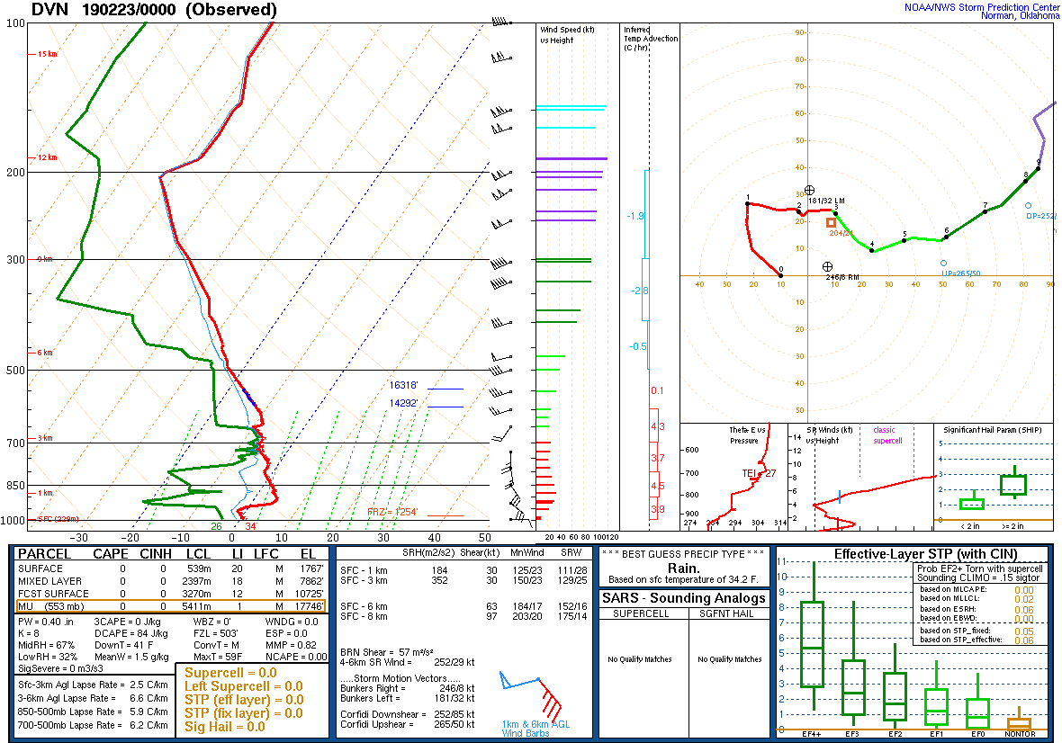
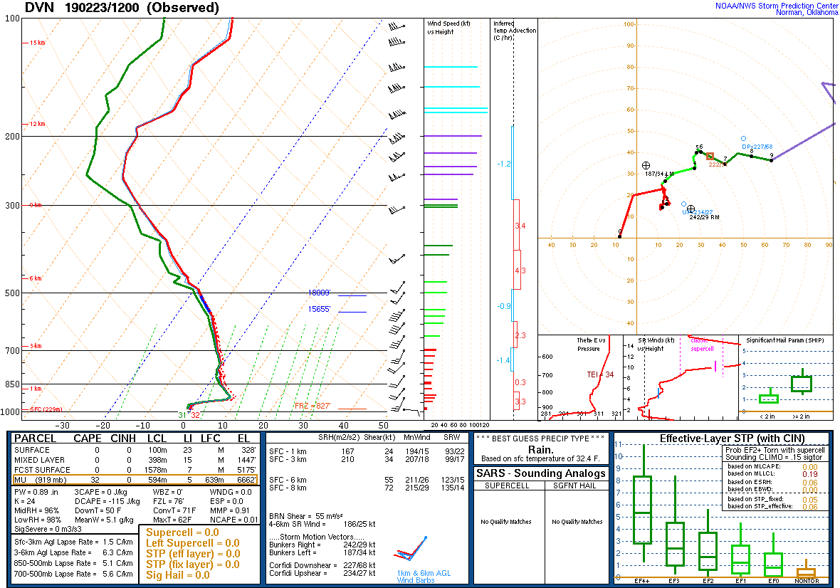
| Figure 1: 02/23/19 00z DVN Sounding | Figure 2: 02/23/19 12z DVN Sounding | Figure 3: 02/24/19 00z DVN Sounding |
 |
 |
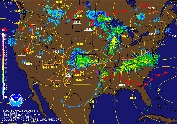 |
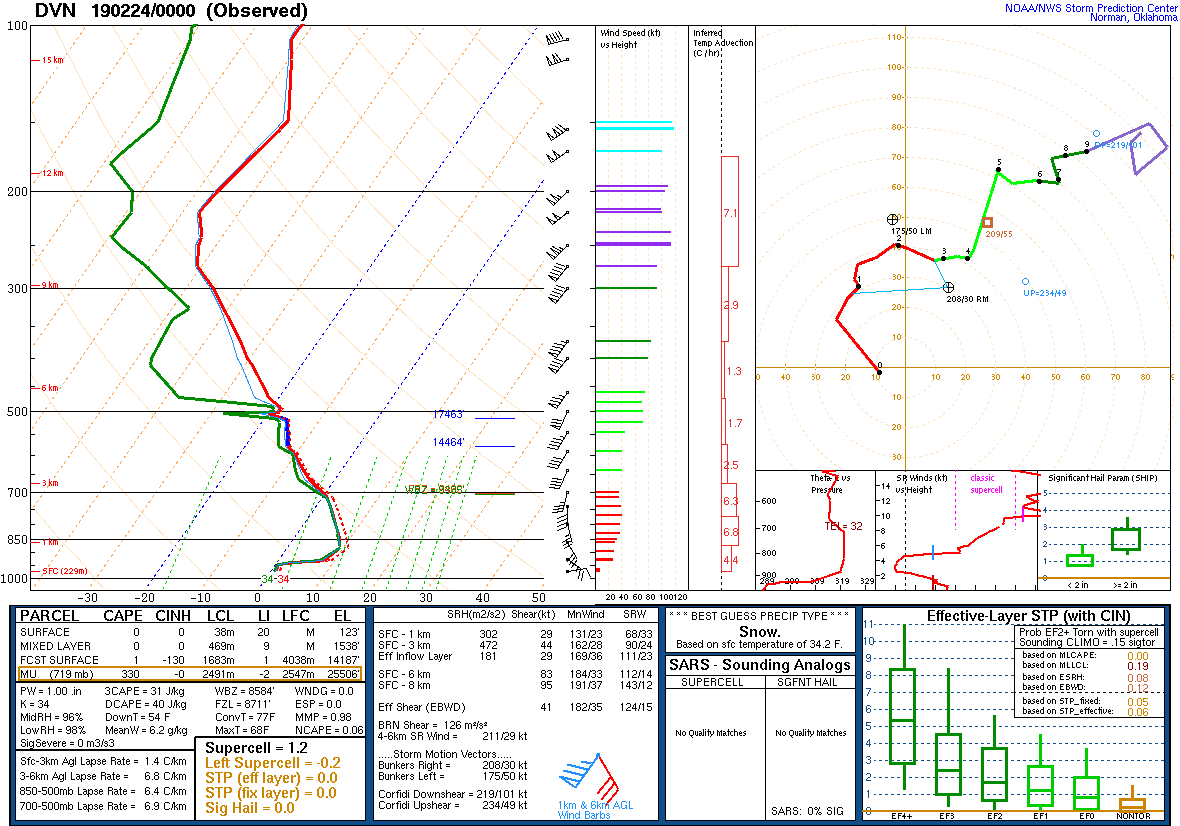
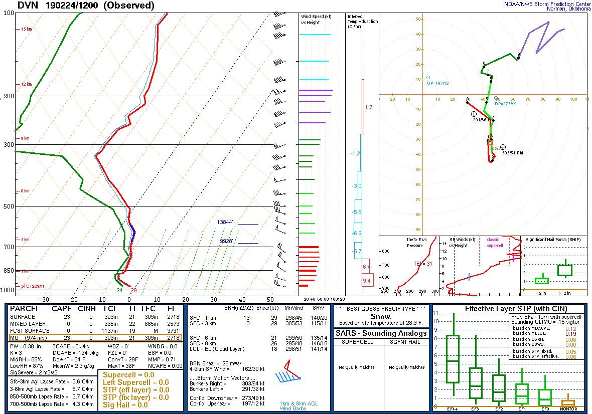
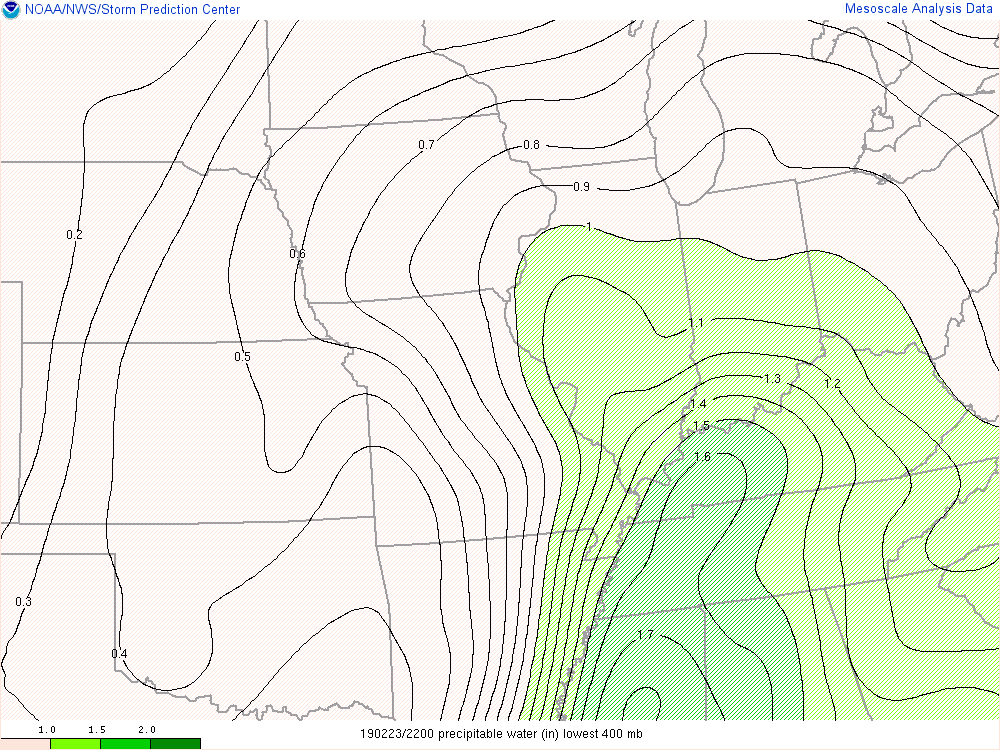
| Figure 4: 02/24/19 12z DVN Sounding | Figure 5: Precipitable Water 02/23/19 22z | Figure 6: WPC Pressure / Radar / Fronts Loop |
| Video Loops | ||
| Figure 1: GOES 16 Water Vapor | Figure 2: MSAS Mean Sea Level Pressure | Figure 3: MSAS 3-hr Pressure Change |
| Figure 4: MSAS Surface Temp | Figure 5: MSAS Surface Dewpoint |
 |
Media use of NWS Web News Stories is encouraged! Please acknowledge the NWS as the source of any news information accessed from this site. |
|