
Dangerous heat will expand from the Gulf Coast into the Southern Plains and Desert Southwest through week's end. Additional extreme heat impacting the Pacific Northwest will shift to the northern Plains by the weekend. Tropical Storm Bertha is expected to continue to impact portions of the northwestern Gulf Coast from south central Louisiana to the upper Texas coast today. Read More >
Quad Cities, IA/IL
Weather Forecast Office
|
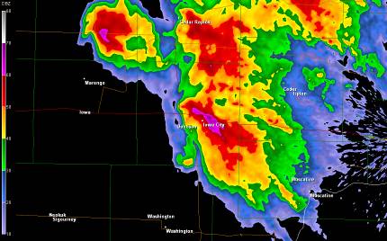
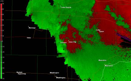
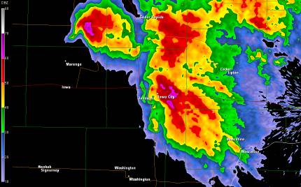
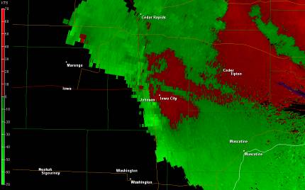
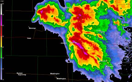
Radar images from April 13th, 2006. Click on images for larger view. |
|
|
WSR-88D radar reflectivity images of the Iowa City tornadic supercell thunderstorm at 624, 629 and 633 pm. The scale is on the left in each figure. Warmer colors indicate higher intensity and cooler colors indicate lesser intensities.
|
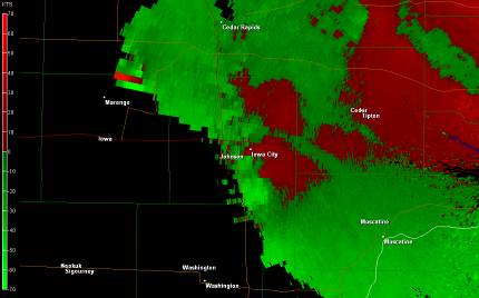
WSR-88D radar velocity images of the Iowa City tornadic supercell thunderstorm at 624, 629 and 633 pm. The scale is on the left in each figure. Green shades indicate motion toward the radar and red shades indicate motion away from the radar. The radar is located to the east (right) on the image. A counter clockwise circulation (called a mesocyclone) is apparent just south of Iowa City at 633 pm where the green (toward the radar) and red (away from the radar) are adjacent to each other.
|
 |
 |
 |
 |
 |
 |
Hazardous Weather
Watches, Warnings, & Advisories
Briefing
Hazards Page
View Local Storm Reports
Submit Report
Road Reports
Text Products
Forecasts
Fire Weather
Briefing
Hourly Forecast Graphs
Forecast Discussion
User-Defined Area
Activity Planner
Local Forecasts
Space Weather
Text Products
River Graphs
Airport Forecasts
Snow and Ice Probabilities
Winter Storm Severity Index (WSSI)
Current Conditions
Observations
Drought Monitor
Radar
Satellite
Text Products
Rivers and Lakes
River Graphs
Sunrise/Sunset Tables
Seasons (Equinoxes/Solstices)
Road Reports
Past Weather
Recent Observation History
Climate Summaries
Past Events
Climate Normals/Averages
Climate Records
Climate/Almanac Data
Holiday Climatology
Climate Maps
Monthly Climate Stats
Annual Climate Stats
Observation Site History
Sunrise/Sunset Tables
US Dept of Commerce
National Oceanic and Atmospheric Administration
National Weather Service
Quad Cities, IA/IL
9040 N Harrison Street
Davenport Municipal Airport
Davenport, IA 52806-7326
563-386-3976
Comments? Questions? Please Contact Us.

