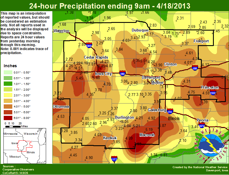
Two days of widespread heavy rain fell on already saturated soils on April 17th and 18th. The initial result was widespread flash flooding, followed by area rivers that rose to major and record flood levels.
Summary of Area Rivers
|
River
|
Location |
Flood
Stage |
Record |
Forecast
Crest |
Actual Crest
(Preliminary) |
| Maquoketa River | Manchester (MCHI4) |
14
|
24.48 ft 07/24/2010
|
crested
|
~12.87 ft. evening of 4/18
(10th highest on record) |
| Maquoketa (MAQI4) |
24
|
35.26 ft 07/26/2010
|
crested
|
~26.28 ft. evening of 4/18 |
|
| Wapsipinicon River | Anamosa (Shaw Rd) |
14
|
26.18 ft 06/13/2008
|
crested |
~16.33 ft. afternoon of 4/19
(10th highest on record) |
| Dewitt (DEWI4) |
11
|
14.19 ft 06/17/1990
|
crested |
~13.70 ft. morning of 4/19
(4th highest on record) |
|
| Cedar River | Conesville (CNEI4) | 13 | 23.40 ft 06/15/2008 | crested | ~15.39 ft. morning of 4/19 (not in the top 10 crests) |
|
Iowa River
|
Marengo (MROI4) |
14
|
21.38 ft 06/12/2008
|
crested |
~17.67 ft. evening of 4/18
(not in the top 10 crests) |
| Lone Tree (LNTI4) |
15
|
23.15 ft 06/15/2008
|
crested |
~21.99 ft. afternoon of 4/19
(3rd highest on record) |
|
| Columbus Jct. (CJTI4) |
19
|
32.30 ft 06/15/2008
|
crested |
~25.82 ft. evening of 4/19
(3rd highest on record) |
|
| Wapello (WAPI4) | 20 | 32.15 ft 06/14/2008 | crested |
~28.13 ft. around midnight 4/19-4/20
(5th highest on record)
|
|
|
English River
|
Kalona (KALI4) |
14
|
22.55 ft 07/06/1993
|
crested
|
~22.6 ft. morning of 4/19 |
|
North Skunk River
|
Sigourney (SIGI4) |
16
|
25.33 ft 03/31/1960
|
crested |
~23.27 ft. afternoon of 4/19
(6th highest on record) |
|
Skunk River
|
Augusta (AGSI4) |
15
|
27.05 ft 04/23/1973
|
crested |
~22.00 ft. morning of 4/21
(not in the top 10 crests) |
|
Des Moines River
|
Keosaqua (KEQI4) |
22
|
32.66 ft 07/13/1993
|
crested
|
~27.26 ft. evening of 4/18
(7th highest on record) |
| St. Francisville (SFLM7) |
21
|
32.02 ft 07/15/1993
|
crested
|
~26.55 ft. evening of 4/18
(5th highest on record) |
|
|
Pecatonica River
|
Freeport (FEEI2) |
13
|
19.76 ft 03/16/1929
|
crested |
~13.82 ft. afternoon of 4/19
(not in the top 10 crests) |
|
Rock River
|
Como (CMOI2) |
10
|
19.60 ft 02/16/1918
|
crested |
~13.21 ft. afternoon of 4/20
(not in the top 10 crests) |
| Joslin (JOSI2) |
12
|
19.24 ft 06/07/2002
|
crested |
~19.13 ft. afternoon of 4/21
(2nd highest on record) |
|
| Moline (MLII2) |
12
|
16.38 ft 03/06/2008
|
crested |
~16.53 ft. evening of 4/21 (RECORD HIGHEST CREST) |
|
|
Green River
|
Geneseo (GENI2) |
15
|
18.77 ft 10/18/1998
|
crested
|
~18.35 ft. afternoon of 4/18
(3rd highest on record) |
|
La Moine River
|
Colmar (CLMI2) |
20
|
27.03 ft 01/03/1965
|
crested | ~28.91 ft. evening of 4/19 (RECORD HIGHEST CREST) |
|
Fox River
|
Wayland (WYLM7) |
15
|
23.07 ft 06/15/2011
|
crested |
~18.90 ft. morning of 4/19
(not in the top 10 crests) |
| Mississippi River | Dubuque (DBQI4) |
17
|
26.81 ft 04/26/1965 | crested |
~17.25 ft. morning of 4/19 |
| Fulton LD 13 (FLTI2) |
16
|
24.75 ft 04/28/1965 | crested | ~16.92 ft. around noon 4/20 (not in the top 10 crests) |
|
| Camanche |
17
|
24.65 ft 04/28/1965 | crested | ~18.78 ft. morning of 4/20 (not in the top 10 crests) |
|
| Le Claire LD 14 (LECI4) |
11
|
17.75 ft 04/28/1965 | crested | ~12.57 ft. afternoon of 4/20 (not in the top 10 crests) |
|
| Rock Island LD 15 (RCKI2) |
15
|
22.63 ft 07/09/1993 | crested | ~19.12 ft. morning of 4/21 (not in the top 10 crests) |
|
| Illinois City LD 16 (ILNI2) |
15
|
24.10 ft 07/09/1993 | crested | ~20.29 ft. morning of 4/22 (6th highest crest on record) |
|
| Muscatine |
16
|
25.61 ft 07/09/1993 | crested | ~21.86 ft. morning of 4/22 (6th highest crest on record) |
|
| New Boston LD 17 (NBOI2) |
15
|
25.90 ft 07/09/1993 | crested | ~22.22 ft. night of 4/21 (5th highest crest on record) |
|
| Keithsburg |
14
|
24.49 ft 06/17/2008 | crested | ~20.57 ft. morning of 4/22 (4th highest crest on record) |
|
| Gladstone LD18 (GLDI2) |
10
|
22.46 ft 06/17/2008 | crested | ~18.01 ft. around noon 4/22 (3rd highest crest on record) |
|
| Burlington |
15
|
25.73 ft 06/17/2008 | crested | ~22.26 ft. morning of 4/22 (3rd highest crest on record) |
|
| Keokuk LD 19 (EOKI4) |
16
|
27.58 ft 07/10/1993 | crested | ~22.17 ft. morning of 4/20 (5th highest crest on record) |
|
| Gregory Landing |
15
|
28.49 ft 07/09/1993 | crested | ~23.55 ft. afternoon of 4/20 (5th highest crest on record) |
|
Photo of Flooding in Cedar Rapids |
Area Rainfall Totals from April 17-18th |
Specific Rainfall Reports (inches) |
||||||||||||||||||||||||||||||
|
|
|
*New Record for the Date |
||||||||||||||||||||||||||||||
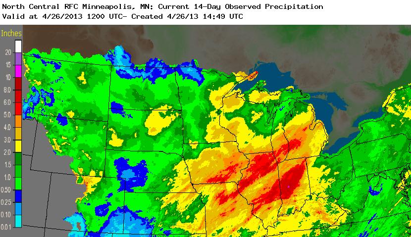
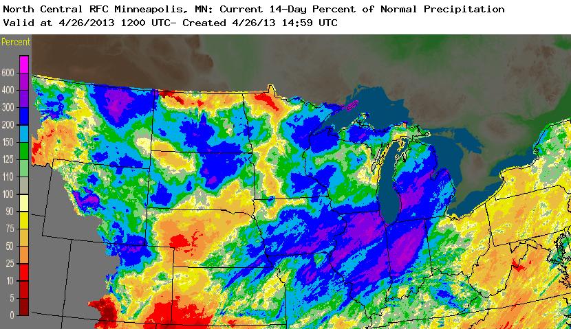
| 24 hr Rainfall Amounts | 14 day Reigonal Rainfal | 14 day Regional Departure from Normal Rainfall | ||||||||||||||||||||||||||||||
 |
 |
 |
||||||||||||||||||||||||||||||


.jpg)
