Widespread life-threatening flash and urban flooding continues in south-central Texas, with considerable flooding impacts possible across central Texas. Wildfire smoke is impacting air quality across much of the Great Lakes region into southern New England and the Mid-Atlantic. Monsoonal thunderstorms may produce isolated to scattered flash flooding across the Southwest into the Great Basin. Read More >
Overview
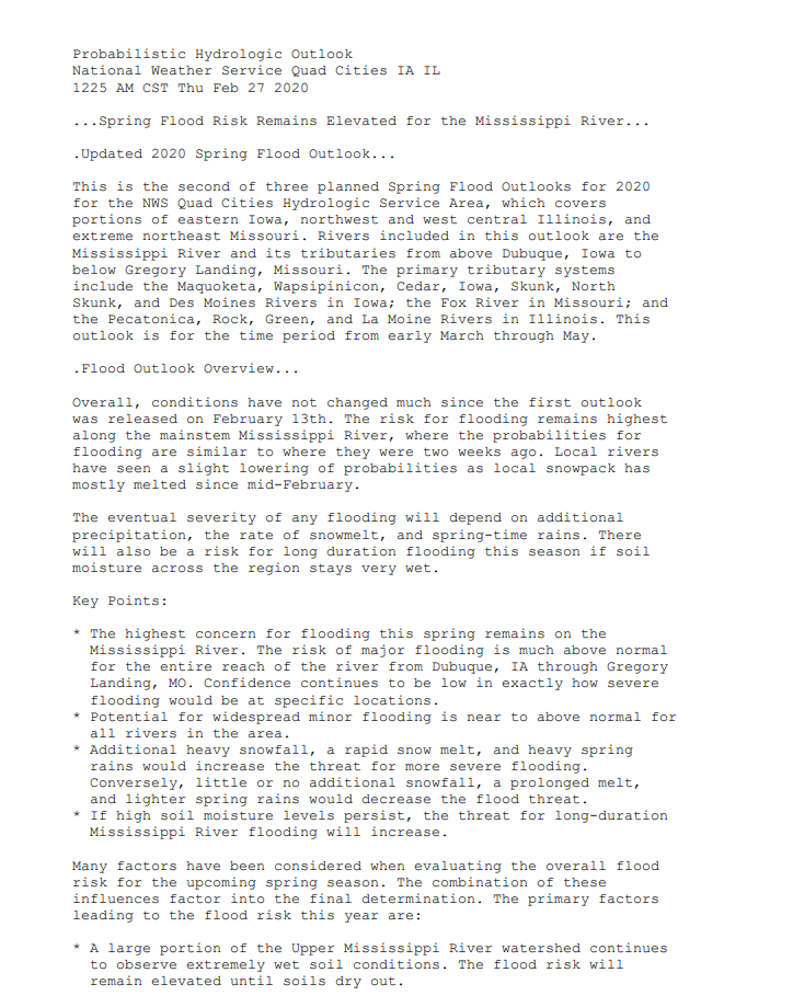
This updated Spring Flood and Water Resources Outlook is for the Quad Cities Hydrologic Service Area (HSA), which covers portions of eastern Iowa, northwest and west central Illinois, and extreme northeast Missouri. This includes the Mississippi River from above Dubuque, Iowa to below Gregory Landing, Missouri and its tributaries. The primary tributary river basins include the Maquoketa, Wapsipinicon, Cedar, Iowa, Skunk, and Des Moines Rivers in Iowa, the Fox River in Missouri, and the Pecatonica, Rock, Green, and La Moine Rivers in Illinois. This outlook is for the time period from mid March through mid June.
Probabalistic Hydrologic Outlook
Use the links below to find the Graphical Probabilities and the Numerical Probabilities respectively.
|
Graphical Hydrologic Outlooks |
2-Pager on Spring Flood Risk | Statistical Hydrologic Outlook | ||||||
|
|
|
||||||
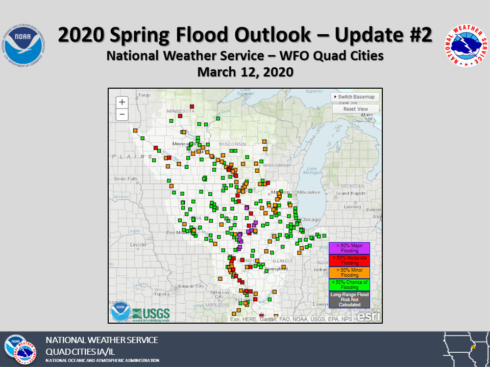
Flood Outlook
Overall, there has been a noticeable improvement in the latest probabilities for flooding compared to the outlook released on February 28th, especially on the Mississippi River. The probabilities of reaching major flood stage on the Mississippi River have dropped substantially (e.g. KHBI2 probability of major flood dropped from 94% to 59%). This drop was due to a prolonged period of dry weather across much of the Mississippi River Valley and a favorable snow melt. However, it remains important to note that the overall risk of flooding remains high through the Spring.
The severity of any flooding will depend on additional rain and snow that fall this Spring. There will also be a risk for long duration flooding this season if soil moisture across the region stays very wet.
Key Points:
Advanced Hydrologic Prediction Service (AHPS)
 |
 |
|
| Observed Conditions | Forecast Conditions | Long-Range Outlooks |
Flood Category definitions:
Many factors are have been considered when determining the overall flood risk for the Spring, with the combination of these influences factoring into the final determination. These factors are discussed in detail below.
Seasonal Precipitation
Little to no measurable precipitation fell across the Midwest and portions of the Mississippi River Valley from the end of Meteorological Winter to
mid March, giving the soils a chance to dry out and for snow to melt at a favorable pace. Only recently did the area see a period of long duration
moderate rainfall, with three quarters to one inch of rain observed on March 09. This generally led to in-bank rises along rivers. Otherwise,
precipitation across the area has generally been below normal.

As mentioned in previous outlooks, the primary driver for our Spring flood potential is the above normal precipitation observed in the upper
Mississippi River Valley over the winter. That precipitation plays a part in raising the risk for flooding on the Mississippi River, while having
lesser influence on local rivers.
 |
 |
Below you will find graphics of the precipitation accumulated this winter season (left) and how this amount of moisture compares to normal in percentage (right). These graphics are courtesy of the Midwest Regional Climate Center.
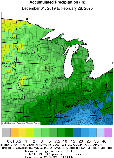 |
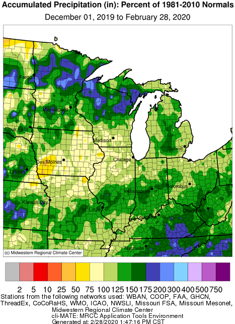 |
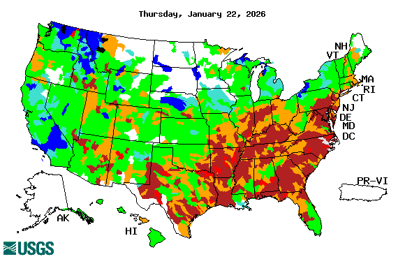
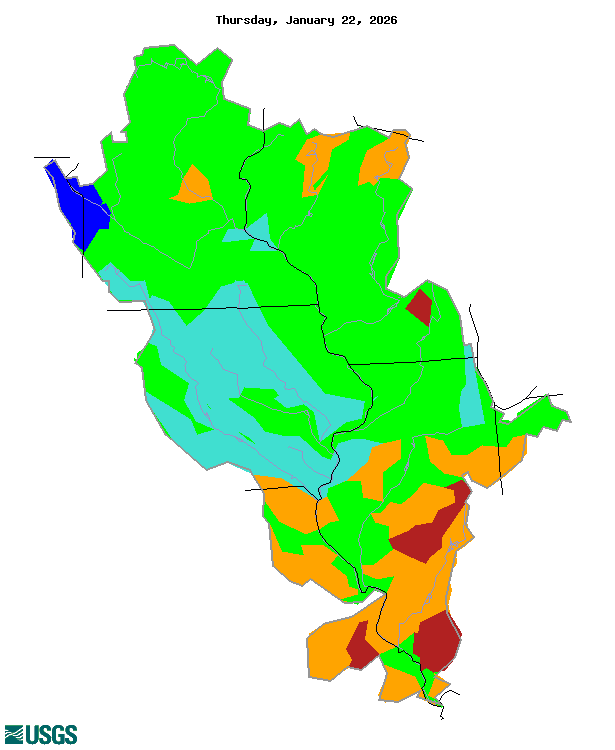
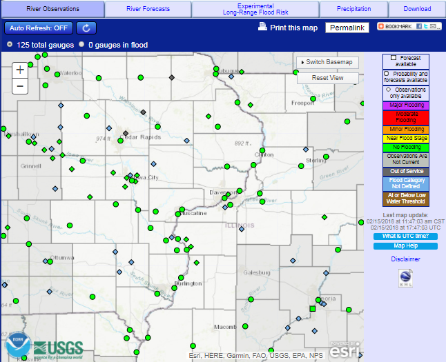
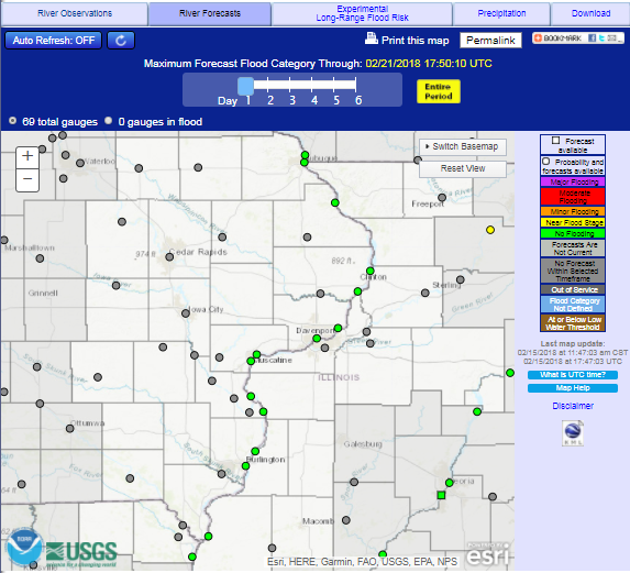
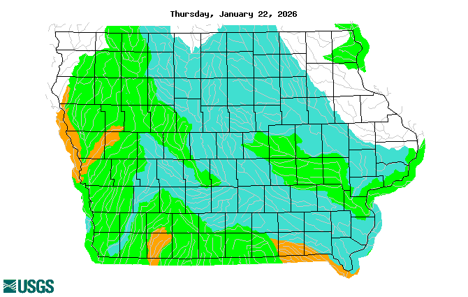
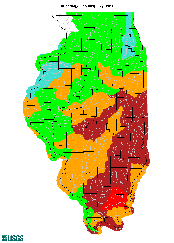
River Conditions
River levels remain near to well above normal across the majority of the Upper Mississippi River watershed. While dry conditions over the
second half of February and early March did allow for river levels to recede slightly, recent rainfall, snow melt and subsequent runoff
have caused rises on many rivers.

The significance of high streamflows to flood risk is that a river with higher water levels will have less space for additional water.
As a result, flood levels can be reached with lesser runoff than it would take given normal river levels for late winter/early spring.
|
|
|
 |
 |
 |
| Iowa | Illinois | Missouri |
| Images courtesy of the USGS |
Soil Conditions
Wet soils have persisted through the winter months as moisture from last fall was locked into the soils during the cold season.
The wettest soils are currently observed across Minnesota, Wisconsin, northern Iowa and northern Illinois as of early March.
To the south, ground thawing contributed to soils drying out across much of Iowa and Illinois. However, recent rains have introduced
additional saturation.

The threat for river rises from snowmelt or spring rainfall runoff due to very wet soils remains high for the Mississippi River as the
entire watershed is experiencing wet to nearly saturated soils. Where soils are saturated, little runoff will be able to be absorbed
by the soils, so water from both snowmelt and rainfall would efficiently move into the river system. Local watersheds have a
slighly elevated risk for high runoff from spring rains as these watersheds are observing wetter than normal soils.
|
|
| Image courtesy of the NWS Climate Prediction Center |
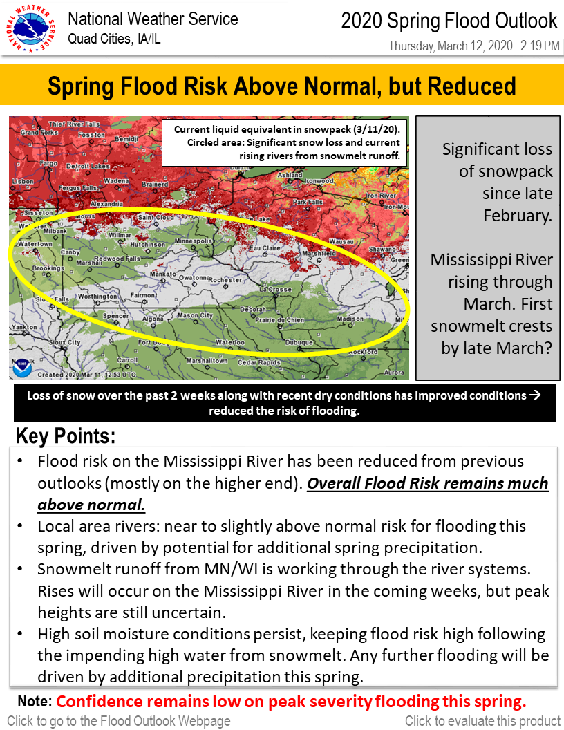
Snow Cover and Liquid Water Content
The latest analysis shows snowpack remaining in Minnesota and Wisconsin mainly north of Interstate 94. Much of the snow along and
south of Interstate 94 that was present in the previous outlook melted over the past week thanks to warm temperatures in the
Mississippi River Valley region. This snowmelt is working through rivers in Minnesota, Wisconsin and northeast Iowa per latest
forecasts. In the snowpack that remains, liquid water content generally ranges from 3 to 6 inches. Isolated pockets of 8 inches or
greater were still observed in northern Wisconsin around the upper basin of the Wisconsin River.

The rapid melt that occurred last week with the dry weather and warm temperatures will bring rises through March, with many locations
expected to experience some degree of flooding. The rate at whichthe remaining snowpack melts may contribute to the severity of
flooding that occurs. The watersheds for the local rivers have no snow cover, which lessens the risk for additional flooding concerns. Unless local
snowpack builds significantly, any local river flooding will be the result of spring rains.
|
|
||||
|
||||
| Images courtesy of the National Operational Hydrologic Remote Sensing Center (NOHRSC) |
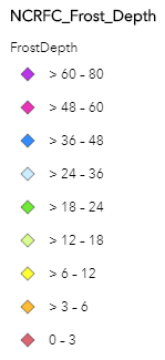
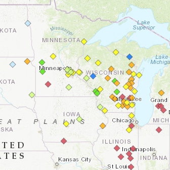
Frost Depth
Temperatures were above normal across the region this winter into early March, with only limited periods of extreme cold. This led to
little to no frost depth over much of the mid-Mississippi River Valley. Further into northern Iowa, Wisconsin and Minnesota, frost
depths ranged from 6 inches to as much as 22 inches where colder temperatures and snowpack have persisted.

The depth of frozen ground contributes to the flood risk by implying any frozen ground will cause efficient runoff from snowmelt or
rainfall. The depth of frozen ground is also a factor to how long it might take for the ground to thaw. Shallower frozen ground leads to
an early thaw, allowing the ground to dry out and infiltration of runoff.
| Frost Depths - North Central River Forecast Center | |||
Regional Frost Depths as of March 12, 2020 |
Ice Jam Flooding
The warmer weather this winter has into early March has limited river ice. As of mid March, there is little to no ice cover on area rivers, thus diminishing
the threat for ice jam flooding. It is possible that cold air will return still, but without a long period of extreme cold, the risk for development of thick river ice
will be low. This keeps the risk for spring break-up ice jams low.
Drought
According to the U.S. Drought Monitor, there are no areas in the Midwest under drought conditions.
|
|
| Image courtesy of the US Drought Monitor |
The latest outlook from the Climate Prediction Center favors a high probability of below normal temperatures and above normal
precipitation in the upper Mississippi River Valley through the end of March.

Looking at the outlook through May, temperatures across the Upper Midwest look to have equal chances for Above, Near, or Below normal.
This may mean a similar pattern which has been observed through winter will continue, with changes from warmer to colder occurring
frequently. Normal high temperatures are now above freezing. The impact to the remaining snowpack will depend on how warm daily highs get, and
if lows drop below freezing during the overnight hours.

Precipitation outlooks for the next three months do indicate higher potential for above normal precipitation, but keep the highest risk
for above normal precipitation generally to the south and east of the region. This indicates a more active weather pattern could come
into play later in the spring.
| 8 to 14 day Temperature Outlook | 8 to 14 day Precipitation Outlook |
 |
 |
|
March Temperature Outlook |
March Precipitation Outlook |
 |
 |
Archived Recordings and Situation Reports:
March 12, 2020 Webinar Recording
River and streamflow information:
Flood safety and flood insurance information:
Precipitation, temperature, and soil moisture information:
Questions or Comments
If you have questions or comments about this spring flood and water resource outlook please contact:
Jessica Brooks
Service Hydrologist
National Weather Service
9050 Harrison St
Davenport, IA 52806
563-391-7094 ext 493
Email: jessica.brooks@noaa.gov
 |
Media use of NWS Web News Stories is encouraged! Please acknowledge the NWS as the source of any news information accessed from this site. |
|