Scattered thunderstorms with severe gusts, hail and a tornado risk are possible near a cold front from the Ohio Valley to the Mid-Atlantic tonight. Tropical Storm Bertha is expected to bring tropical storm conditions to portions of the Gulf Coast from the panhandle of Florida into Louisiana through Wednesday. Read More >
Overview
|
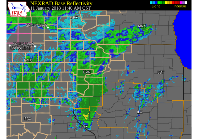
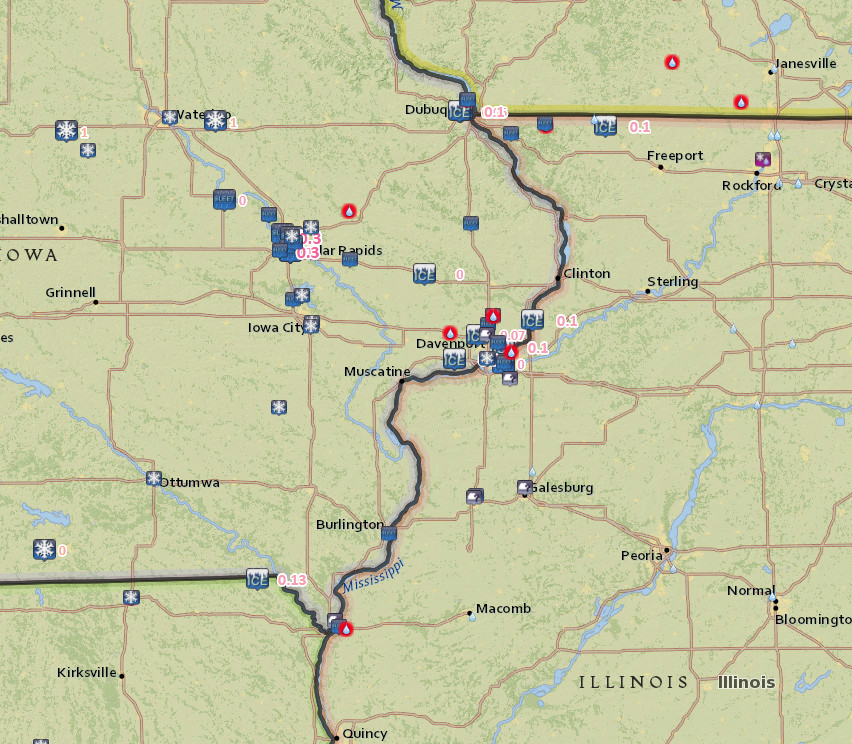
Rain, freezing rain, sleet, and snow fell across much of the region on Thursday, as a strong cold front pushed east into Illinois. Temperatures dropped sharply behind the cold front, with temperatures dropping 15 to 25 degrees in a few hours. Along and behind the front, a mix of rain and freezing rain fell during the late morning and early afternoon, causing a light glaze of ice on surfaces. This caused very slick conditions on area roads and sidewalks. Precipitation quickly changed to sleet and snow between 1 and 3 pm in the afternoon, with Cedar Rapids metro receiving up to a quarter of an inch of sleet. Snowfall accumulation less than 1 inch fell northwest of a line from Grinnell Iowa to Independence Iowa. Strong northwest winds between 15 and 25 mph were also common behind the front, with wind gusts up to 35 mph. |
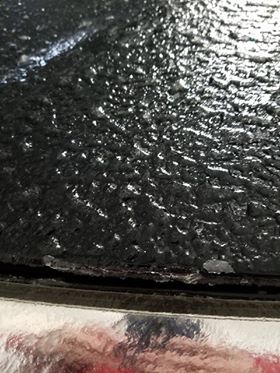
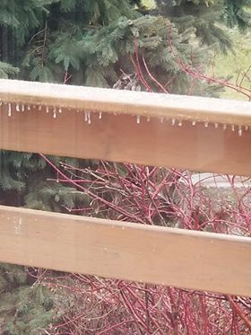
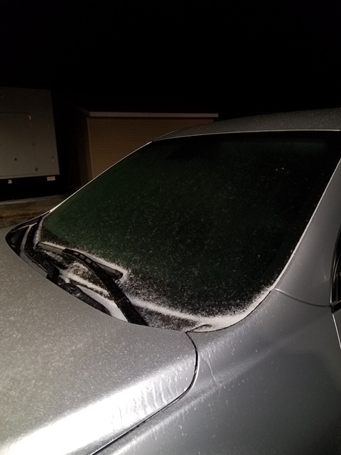
Photos & Video:
 |
 |
 |
| Blue Grass, IA (Christian Allen) |
Blue Grass, IA (Christian Allen) |
NWS Davenport (Tim Gross) |
Storm Reports
| Interactive Storm Report Map |
 |
PRELIMINARY LOCAL STORM REPORT...SUMMARY
NATIONAL WEATHER SERVICE QUAD CITIES IA IL
400 PM CST THU JAN 11 2018

..TIME...   ...EVENT...      ...CITY LOCATION...     ...LAT.LON...
..DATE...   ....MAG....      ..COUNTY LOCATION..ST.. ...SOURCE....
            ..REMARKS..

1209 PM     FREEZING RAIN    LOWDEN                  41.86N 90.92W
01/11/2018  E0.00 INCH       CEDAR              IA   CO-OP OBSERVER

            MIX OF FREEZING RAIN AND SLEET. SIDEWALKS AND ROADS ARE
            ICY. TEMPERATURE DROPPED FROM 49 TO 23 DEGREES BETWEEN 8
            AM AND NOON.

1230 PM     FREEZING RAIN    1 W BETTENDORF          41.56N 90.49W
01/11/2018  E0.10 INCH       SCOTT              IA   TRAINED SPOTTER

            CARS ARE ICING UP.

1231 PM     FREEZING RAIN    2 WNW DUBUQUE           42.52N 90.72W
01/11/2018  E0.00 INCH       DUBUQUE            IA   TRAINED SPOTTER

            GLAZE OF ICE. SECONDARY ROADS ARE SLICK. ICE ON CARS,
            LIMBS, AND POWER LINES.

1235 PM     FREEZING RAIN    BLUE GRASS              41.51N 90.76W
01/11/2018  E0.10 INCH       SCOTT              IA   TRAINED SPOTTER

            AT LEAST A TENTH OF AN INCH OF ICE ACCUMULATION ON TRUCK.


1236 PM     FREEZING RAIN    3 ENE CHARLIE HEATH MEM 40.60N 91.84W
01/11/2018  M0.13 INCH       CLARK              MO   TRAINED SPOTTER

            1/8 INCH OF ICE ACCUMULATION ON LIMBS. SOME SLEET FALLING
            NOW AND ACCUMULATING ON ELEVATED SURFACES.

1240 PM     SLEET            3 NNW CEDAR RAPIDS      42.02N 91.70W
01/11/2018  E0.00 INCH       LINN               IA   TRAINED SPOTTER

            SLEET BEGINNING TO ACCUMULATE. ROADS ARE TERRIBLE.

1245 PM     SLEET            1 SSE CEDAR RAPIDS      41.95N 91.66W
01/11/2018  E0.00 INCH       LINN               IA   TRAINED SPOTTER

            MODERATE SLEET FALLING FOR THE LAST 15-20 MINUTES. ROADS
            ARE EXTREMELY SLICK.

1250 PM     SLEET            1 SE VINTON             42.16N 92.02W
01/11/2018  E0.00 INCH       BENTON             IA   TRAINED SPOTTER

            A HALF INCH OF ICY/WET SNOW AND SLEET HAS ACCUMULATED.
            SLEET IS STILL FALLING. ROADS ARE DANGEROUS.

0110 PM     SLEET            1 SSE CEDAR RAPIDS      41.95N 91.66W
01/11/2018  U0.00 INCH       LINN               IA   TRAINED SPOTTER

            SLEET REDUCING VISIBILITY TO 1/4 MILE AT TIMES. MAJOR
            ROADS ARE COMPLETELY COVERED...INCLUDING MT VERNON ROAD
            AND HIGHWAY 13.

0114 PM     SLEET            MOLINE                  41.49N 90.49W
01/11/2018  E0.00 INCH       ROCK ISLAND        IL   TRAINED SPOTTER

            SLEET IS NOW MIXING IN WITH THE FREEZING RAIN.

0121 PM     FREEZING RAIN    2 WNW DUBUQUE           42.52N 90.73W
01/11/2018  M0.06 INCH       DUBUQUE            IA   TRAINED SPOTTER

            0.06 INCHES ICE ACCUMULATION.

0125 PM     FREEZING RAIN    1 SSW CORDOVA           41.67N 90.33W
01/11/2018  E0.10 INCH       ROCK ISLAND        IL   TRAINED SPOTTER

            A TENTH OF AN INCH OF ICE ACCUMULATION. PRECIPITATION
            STARTING TO TRANSITION TO SLEET.

0158 PM     SLEET            1 SSE CEDAR RAPIDS      41.95N 91.66W
01/11/2018  M0.30 INCH       LINN               IA   TRAINED SPOTTER

            0.3 OF AN INCH OF SLEET ACCUMULATION SO FAR.

0205 PM     FREEZING RAIN    1 ESE NORA              42.46N 89.93W
01/11/2018  M0.10 INCH       JO DAVIESS         IL   TRAINED SPOTTER

            ICE ACCUM MEASURED ON DECK...NOW SLEETING.

0302 PM     FREEZING RAIN    4 NNW DAVENPORT         41.61N 90.63W
01/11/2018  M0.07 INCH       SCOTT              IA   NWS EMPLOYEE

            TRACE OF SLEET FELL AS WELL.

0312 PM     SLEET            2 NNE CEDAR RAPIDS      42.01N 91.65W
01/11/2018  E0.30 INCH       LINN               IA   TRAINED SPOTTER

0348 PM     SNOW             JESUP                   42.48N 92.07W
01/11/2018  E1.0 INCH        BUCHANAN           IA   TRAINED SPOTTER

0348 PM     FREEZING RAIN    2 WNW DUBUQUE           42.52N 90.73W
01/11/2018  E0.10 INCH       DUBUQUE            IA   TRAINED SPOTTER

            TOTAL ICE ACCUM.
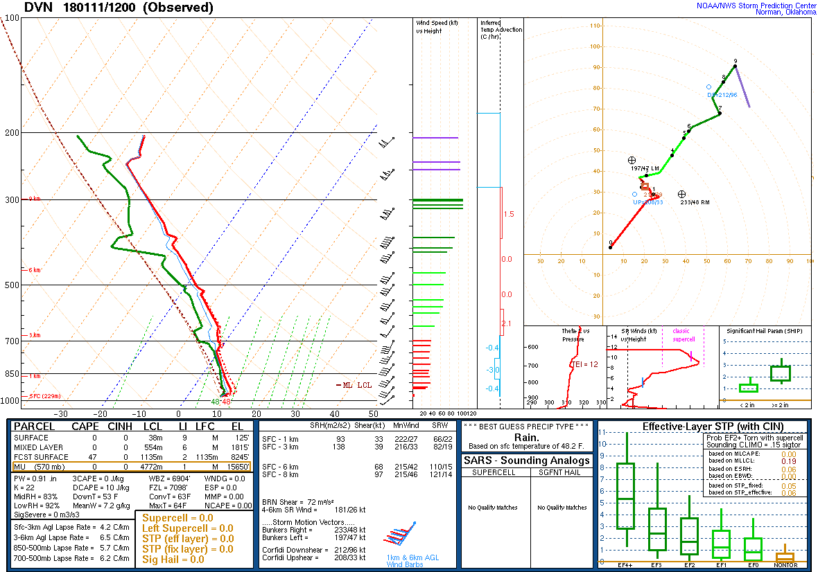
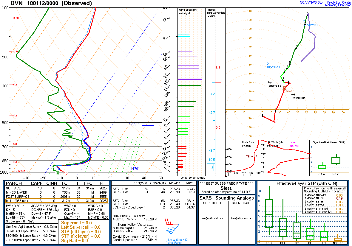
Environment
 |
 |
|
| Figure 7: 12z 1/11 DVN Sounding | Figure 8: 00z 1/12 DVN Sounding |
 |
Media use of NWS Web News Stories is encouraged! Please acknowledge the NWS as the source of any news information accessed from this site. |
|