Scattered thunderstorms with severe gusts, hail and a tornado risk are possible near a cold front from the Ohio Valley to the Mid-Atlantic tonight. Tropical Storm Bertha is expected to bring tropical storm conditions to portions of the Gulf Coast from the panhandle of Florida into Louisiana through Wednesday. Read More >
Overview
|
Jan. 25-26 2021 -
Official National Weather Service Observations
|
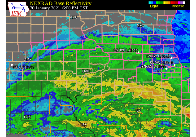
 WPC - Surface Map and Radar Loop |
||||||||
Snowfall Amounts
 |
 |
 |
|
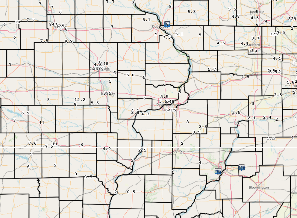
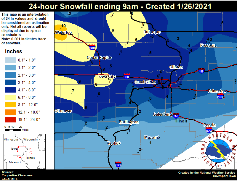
24 hour snow fall in inches,
for eastern Iowa, northwest and west central Illinois,
and northeast Missouri. Reported between Midnight and 9 AM,
Tuesday January 26, 2021.

....IOWA....
NWS Johnston* 5 NNW              12.3
Boone 1 SSW                      11.2
Waterloo ASOS                    10.5
Rickardsville 0.2 W               8.0
Hampton 1 N                       8.0
Guttenberg Dam 10                 8.0
Elkader 6SSW                      7.2
Pella 4 N                         7.1
Iowa City                         7.0  COOP Station
Monticello 1 E                    7.0
Sigourney                         6.9
North Liberty 0.7 SSW             6.5
Bettendorf 1.6 W                  6.1
Park View 0.2 WSW                 6.1
North English                     6.0
Bellevue LD12                     6.0
Fairfield                         6.0
Fairfax 4.0 NW                    6.0
Manchester                        5.6
Cascade                           5.5
Wellman 4.0 E                     5.5
Davenport Arpt                    5.5
Davenport 0.9 WNW                 5.1
Maquoketa                         5.0
Washington                        5.0
Toledo 3 N                        5.0
Dubuque Arpt                      5.0
Solon 0.3 ESE                     5.0
Muscatine 2N                      4.5
Fayette 1 NW                      4.0
Wapello 5.4 SE                    3.8
Anamosa 3 SSW                     3.6
Muscatine 2.1 N                   3.4
Salem 1S                          3.0
Marshalltown 1 NW                 3.0
Donnellson                        2.5
Tripoli 0 N                       2.0
Keosauqua                         1.5
Waukon 3N                         1.0
Mason City 1 NNE                  1.0
Beaconsfield 1 NNE                0.9
....ILLINOIS....
Quad City Arpt                    6.1
Freeport 1.7 NW                   5.0
Moline 0.7 NNE                    4.9
Coal Valley 2.6 E                 4.5
Geneseo 2.0 NW                    4.5
New Windsor 2.0 N                 4.5
Freeport 2.0 NW                   4.0
Mount Carroll                     4.0
Mundelein                         3.7
Mount Carroll 6.8 NNW             3.7
Elizabeth                         3.4
Kewanee 1 E                       3.2
Aledo                             3.0
Princeton 1.1 SE                  3.0
Gladstone LD18                    3.0
Mendota 2 SE                      3.0
Freeport                          3.0
Princeton                         3.0
Oquawka 0.5 N                     2.5
Romeoville                        2.1
Augusta                           2.0
Rockford ASOS                     1.9
Ottawa 4 SW                       1.5
Streator 3 SE                     1.5
Dallas City 3.0 SSE               1.2
Colchester 3.5 NE                 0.8
....MISSOURI....
Columbia                          0.0
....WISCONSIN....
Beloit-College                    6.0
Brodhead 1 SW                     4.7
Steuben 4SE 3 NE                  4.5
Whitewater                        4.5
Madison-ASOS                      3.9
La Crosse WFO                     0.1
Viroqua                           0.1
....MINNESOTA....
Preston                           0.0
Theilman 1SSW                     0.0
|
|
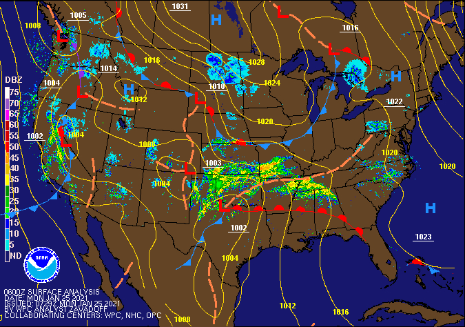
Storm Reports
January 25 10AM - January 26 11PM Storm Reports
Courtesy IEM
|
|
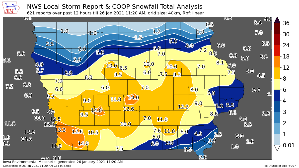
PRELIMINARY LOCAL STORM REPORT...SUMMARY
NATIONAL WEATHER SERVICE QUAD CITIES IA IL
1035 AM CST TUE JAN 26 2021
THE REPORTS BELOW ARE SEPARATED INTO SNOW...AND ICE AND SLEET CATEGORIES...THEN BY AMOUNT...AND ARE NOT NECESSARILY THE FINAL AMOUNT FOR EACH LOCATION. SNOW REPORTS LISTED BY AMOUNT INCHES LOCATION ST COUNTY TIME ------ ----------------------- -- -------------- ------- 12.2 PARNELL IA IOWA 1022 AM 9.0 IOWA CITY IA JOHNSON 0855 AM 8.6 MUSCATINE IA MUSCATINE 0855 AM 8.1 RICKARDSVILLE IA DUBUQUE 0540 AM 8.0 CEDAR RAPIDS IA LINN 1000 AM 8.0 NORTH ENGLISH IA IOWA 0900 AM 7.5 ST. DONATUS IA JACKSON 1000 AM 6.7 IOWA CITY IA JOHNSON 0757 AM 6.5 IOWA CITY IA JOHNSON 0540 AM 6.1 MOLINE QUAD-CITY AIRPOR IL ROCK ISLAND 0522 AM 6.0 FAIRFIELD IA JEFFERSON 0830 AM 6.0 MOUNT VERNON IA LINN 0750 AM 5.8 STANWOOD IA CEDAR 0902 AM 5.8 BETTENDORF IA SCOTT 0802 AM 5.7 MILLEDGEVILLE IL CARROLL 1000 AM 5.5 DAVENPORT IA SCOTT 1000 AM 5.5 2 SSW WILLIAMSTOWN IA JOHNSON 0715 AM 5.5 DAVENPORT MUNICIPAL AIR IA SCOTT 0600 AM 5.1 GALENA TERRITORY IL JO DAVIESS 0730 AM 5.0 CORDOVA IL ROCK ISLAND 1029 AM 5.0 CEDAR RAPIDS IA LINN 1000 AM 5.0 3 NNE STOCKTON IL JO DAVIESS 0905 AM 5.0 DURANT IA CEDAR 0757 AM 5.0 SOLON IA JOHNSON 0645 AM 5.0 NE CEDAR RAPIDS IA LINN 0628 AM 5.0 DUBUQUE REGIONAL AIRPOR IA DUBUQUE 0601 AM 4.9 MOUNT PLEASANT IA HENRY 0747 AM 4.8 MARION IA LINN 0628 AM 4.6 CEDAR RAPIDS IA LINN 0920 AM 4.5 FREEPORT IL STEPHENSON 0839 AM 4.5 2 N MUSCATINE IA MUSCATINE 0745 AM 4.5 NE CEDAR RAPIDS IA LINN 0645 AM 4.3 2 SSW HIAWATHA IA LINN 0825 AM 4.3 ILLINOIS CITY IL ROCK ISLAND 0645 AM 4.3 MUSCATINE IA MUSCATINE 0645 AM 3.8 MUSCATINE IA MUSCATINE 0900 AM 3.8 CEDAR RAPIDS IA LINN 0530 AM 3.5 7 WSW FARMINGTON MO CLARK 1000 AM 3.5 IOWA CITY IA JOHNSON 0900 AM 3.5 GALVA IL HENRY 0747 AM 3.5 6 NE CEDAR RAPIDS IA LINN 0522 AM 3.3 KEWANEE IL HENRY 0730 AM 3.0 CANTRIL IA VAN BUREN 0930 AM 3.0 CAMBRIDGE IL HENRY 0830 AM 2.5 OQUAWKA IL HENDERSON 0839 AM 2.5 MALDEN IL BUREAU 0800 AM 2.0 KEOKUK IA LEE 0922 AM 0.5 CARTHAGE IL HANCOCK 0855 AM |
|
|
 |
Media use of NWS Web News Stories is encouraged! Please acknowledge the NWS as the source of any news information accessed from this site. |
|