Scattered thunderstorms with severe gusts, hail and a tornado risk are possible near a cold front from the Ohio Valley to the Mid-Atlantic tonight. Tropical Storm Bertha is expected to bring tropical storm conditions to portions of the Gulf Coast from the panhandle of Florida into Louisiana through Wednesday. Read More >
Overview
|
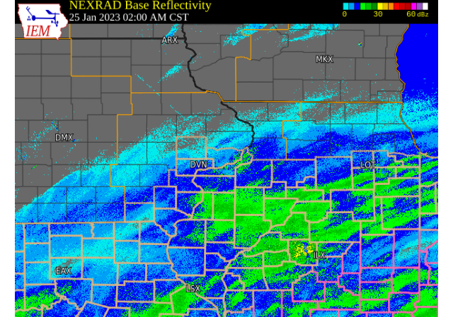
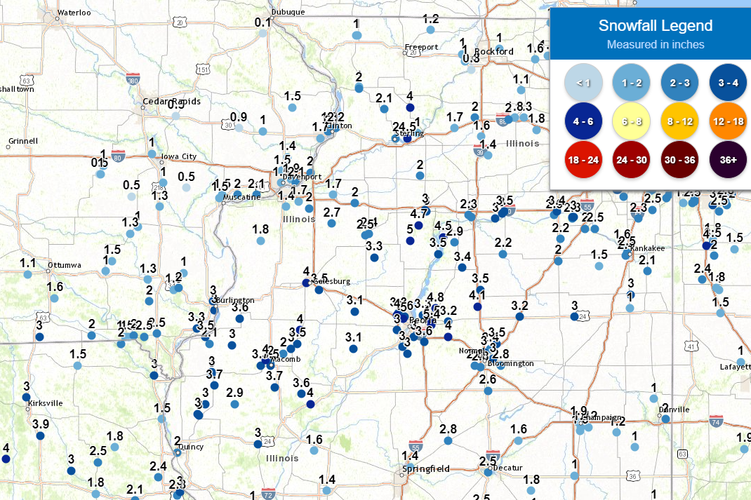
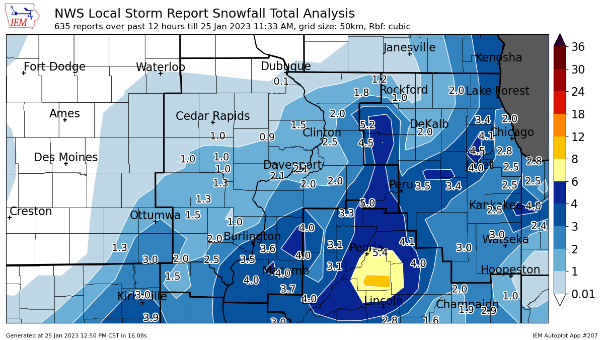
A strong storm system tracked northeast from southeast TX up into the Ohio River valley Tuesday evening and Wednesday morning bringing snow to much of southeast IA, northwest IL, and northeast MO. Snowfall totals between 2 and 4 inches were common south of a line from Mt Pleasant IA, to the Quad Cities, to Sterling IL with some locally higher amounts near 5 inches. This brought snow covered roads and reduced visibilities to the region. Additional light snow fell during the evening bringing another half inch to an inch of snow to portions of the region.
NWS Official Totals Moline: 2.5" These totals ended at Noon Wednesday. |
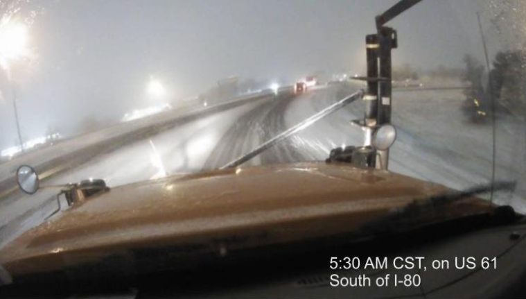 Snowplow Cam - IA DOT |
Preliminary Snow and Precipitation Maps
| Regional Snow Map (courtesy IEM) |
Local Snow Analysis (courtesy IEM) |
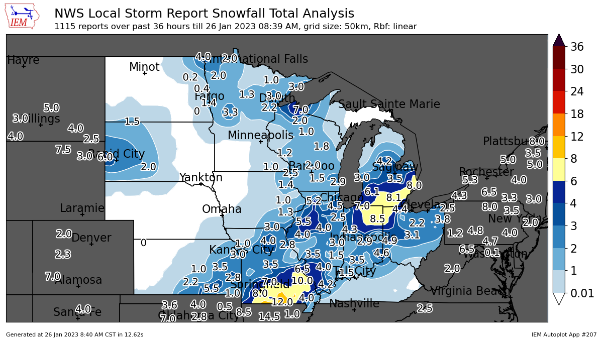
48hr Regional Snow Map (courtesy IEM) |
.png) |
 |
 |
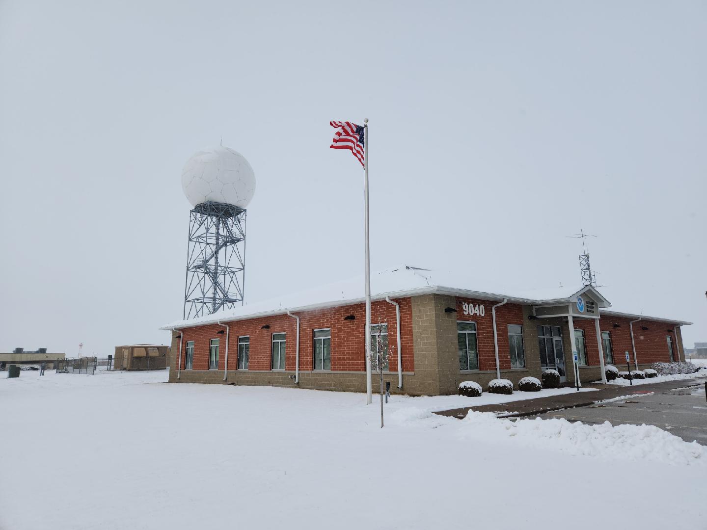
Storm Reports and Photos
|
|
|
 |
| Storm Reports Map Courtesy IEM |
NWS Quad Cities | NW Macomb IL Ethan Schisler |
PRELIMINARY LOCAL STORM REPORT...SUMMARY
NATIONAL WEATHER SERVICE QUAD CITIES IA IL
1231 PM CST WED JAN 25 2023
..TIME... ...EVENT... ...CITY LOCATION... ...LAT.LON...
..DATE... ....MAG.... ..COUNTY LOCATION..ST.. ...SOURCE....
..REMARKS..
0944 AM SNOW MILO 41.20N 89.58W
01/25/2023 E5.0 INCH BUREAU IL PUBLIC
1023 AM SNOW TISKILWA 41.29N 89.51W
01/25/2023 E4.7 INCH BUREAU IL PUBLIC
REPORTED 12CM OF SNOW WHICH IS APPROXIMATELY
4.7 INCHES.
1038 AM SNOW HENNEPIN 41.22N 89.32W
01/25/2023 M4.5 INCH PUTNAM IL PUBLIC
REPORTED 4 TO 4.5 INCHES.
1208 PM SNOW 1 NW MACOMB 40.49N 90.70W
01/25/2023 M4.5 INCH MCDONOUGH IL TRAINED SPOTTER
STORM TOTAL.
0809 AM SNOW CARTHAGE 40.42N 91.13W
01/25/2023 M4.0 INCH HANCOCK IL PUBLIC
0812 AM SNOW 2 WNW MACOMB 40.49N 90.71W
01/25/2023 M4.0 INCH MCDONOUGH IL PUBLIC
0700 AM SNOW BENTLEY 40.34N 91.11W
01/25/2023 M3.7 INCH HANCOCK IL CO-OP OBSERVER
CO-OP OBSERVER STATION BTYI2 BENTLEY.
0740 AM SNOW 3 W MACOMB 40.46N 90.75W
01/25/2023 M3.7 INCH MCDONOUGH IL COCORAHS
COCORAHS STATION IL-MCD-7 COLCHESTER 3.5 NE.
0850 AM SNOW 1 W INDUSTRY 40.33N 90.64W
01/25/2023 M3.7 INCH MCDONOUGH IL TRAINED SPOTTER
AVERAGE MEASUREMENT, STILL SNOWING.
0700 AM SNOW 1 SW STRONGHURST 40.74N 90.91W
01/25/2023 M3.6 INCH HENDERSON IL COCORAHS
COCORAHS STATION IL-HD-1 STRONGHURST 0.4
SSW.
0808 AM SNOW 1 ENE BURLINGTON REGION 40.79N 91.11W
01/25/2023 M3.5 INCH DES MOINES IA TRAINED SPOTTER
UPDATES PREVIOUS SNOW REPORT FROM 1 ENE
BURLINGTON REGIONAL AIRPORT OF 3.0 INCHES OF
SNOW THROUGH 8 AM. LIGHT TO MODERATE SNOW
CONTINUES TO FALL.
0855 AM SNOW 1 W DALLAS CITY 40.63N 91.18W
01/25/2023 M3.5 INCH HANCOCK IL PUBLIC
0953 AM SNOW 1 SE MACOMB 40.46N 90.67W
01/25/2023 M3.5 INCH MCDONOUGH IL PUBLIC
0852 AM SNOW 3 SSW WEVER 40.68N 91.25W
01/25/2023 M3.3 INCH LEE IA PUBLIC
1139 AM SNOW 1 ESE MACOMB 40.46N 90.66W
01/25/2023 M3.3 INCH MCDONOUGH IL TRAINED SPOTTER
STILL LIGHTLY SNOWING.
0633 AM SNOW BUSHNELL 40.56N 90.51W
01/25/2023 M3.0 INCH MCDONOUGH IL TRAINED SPOTTER
0646 AM SNOW CARTHAGE 40.41N 91.13W
01/25/2023 M3.0 INCH HANCOCK IL TRAINED SPOTTER
0700 AM SNOW 1 SE PRINCETON 41.37N 89.45W
01/25/2023 M3.0 INCH BUREAU IL COCORAHS
COCORAHS STATION IL-BU-5 PRINCETON 1.1 SE.
0700 AM SNOW PRINCETON 41.38N 89.46W
01/25/2023 M3.0 INCH BUREAU IL CO-OP OBSERVER
CO-OP OBSERVER STATION PTNI2 PRINCETON.
0800 AM SNOW 2 N BURLINGTON 40.84N 91.12W
01/25/2023 M3.0 INCH DES MOINES IA TRAINED SPOTTER
0800 AM SNOW LA HARPE 40.58N 90.97W
01/25/2023 M3.0 INCH HANCOCK IL CO-OP OBSERVER
CO-OP OBSERVER STATION LAHI2 LA HARPE.
0900 AM SNOW CARTHAGE 40.42N 91.13W
01/25/2023 M3.0 INCH HANCOCK IL PUBLIC
0944 AM SNOW WAYLAND 40.40N 91.58W
01/25/2023 M3.0 INCH CLARK MO PUBLIC
1204 PM SNOW 2 SE DAVENPORT 41.53N 90.57W
01/25/2023 E3.0 INCH SCOTT IA PUBLIC
0710 AM SNOW 1 NW MC NABB 41.19N 89.23W
01/25/2023 M2.9 INCH PUTNAM IL COCORAHS
COCORAHS STATION IL-PM-6 MCNABB 1.4 NW.
1022 AM SNOW CAMBRIDGE 41.30N 90.19W
01/25/2023 M2.7 INCH HENRY IL PUBLIC
STILL LIGHTLY SNOWING.
1205 PM SNOW DAVENPORT AIRPORT 41.61N 90.58W
01/25/2023 M2.7 INCH SCOTT IA OFFICIAL NWS OBS
1.2 INCHES SINCE 6 AM.
0700 AM SNOW DONNELLSON 40.65N 91.56W
01/25/2023 M2.5 INCH LEE IA CO-OP OBSERVER
CO-OP OBSERVER STATION DNNI4 DONNELLSON.
0732 AM SNOW 1 SSW KEWANEE 41.23N 89.93W
01/25/2023 M2.5 INCH HENRY IL TRAINED SPOTTER
1033 AM SNOW 4 NNE CROTON 40.63N 91.66W
01/25/2023 E2.5 INCH LEE IA TRAINED SPOTTER
1128 AM SNOW 5 W MORRISON 41.81N 90.08W
01/25/2023 M2.5 INCH WHITESIDE IL TRAINED SPOTTER
1205 PM SNOW 3 SW QUAD CITY AIRPORT 41.40N 90.55W
01/25/2023 M2.5 INCH ROCK ISLAND IL OFFICIAL NWS OBS
1.1 INCHES SINCE 6 AM.
0700 AM SNOW 1 E KEWANEE 41.24N 89.90W
01/25/2023 M2.4 INCH HENRY IL CO-OP OBSERVER
CO-OP OBSERVER STATION KEWI2 KEWANEE 1 E.
1120 AM SNOW 1 ESE NEW LONDON 40.92N 91.40W
01/25/2023 M2.3 INCH HENRY IA TRAINED SPOTTER
0935 AM SNOW FULTON 41.86N 90.16W
01/25/2023 M2.2 INCH WHITESIDE IL TRAINED SPOTTER
1013 AM SNOW FULTON 41.86N 90.16W
01/25/2023 E2.2 INCH WHITESIDE IL TRAINED SPOTTER
0700 AM SNOW 1 N RIVERDALE 41.54N 90.47W
01/25/2023 M2.1 INCH SCOTT IA COCORAHS
COCORAHS STATION IA-ST-42 RIVERDALE 0.5 N.
0850 AM SNOW 1 ENE MONTPELIER 41.47N 90.78W
01/25/2023 M2.1 INCH SCOTT IA TRAINED SPOTTER
1058 AM SNOW MILLEDGEVILLE 41.97N 89.78W
01/25/2023 M2.1 INCH CARROLL IL TRAINED SPOTTER
UPDATES THE PREVIOUS SNOW REPORT OF 1.9
INCHES FROM MILLEDGEVILLE.
0645 AM SNOW ATKINSON 41.42N 90.01W
01/25/2023 E2.0 INCH HENRY IL PUBLIC
0700 AM SNOW 1 S SALEM 40.84N 91.62W
01/25/2023 M2.0 INCH HENRY IA CO-OP OBSERVER
CO-OP OBSERVER STATION SLHI4 SALEM 1 S.
0700 AM SNOW 3 NW OHIO 41.58N 89.50W
01/25/2023 M2.0 INCH BUREAU IL COCORAHS
COCORAHS STATION IL-BU-11 WALNUT 5.3 ENE.
0700 AM SNOW 1 NE MACOMB 40.48N 90.67W
01/25/2023 M2.0 INCH MCDONOUGH IL CO-OP OBSERVER
CO-OP OBSERVER STATION MQBI2 MACOMB.
0700 AM SNOW 2 SE SCOTTSBURG 40.53N 90.57W
01/25/2023 M2.0 INCH MCDONOUGH IL PUBLIC
0705 AM SNOW 3 ENE CHARLIE HEATH MEM 40.59N 91.84W
01/25/2023 M2.0 INCH CLARK MO TRAINED SPOTTER
0706 AM SNOW 1 SE NEW LONDON 40.92N 91.39W
01/25/2023 M2.0 INCH HENRY IA PUBLIC
0840 AM SNOW 1 E CLINTON 41.84N 90.22W
01/25/2023 M2.0 INCH CLINTON IA TRAINED SPOTTER
SNOWFALL MEASUREMENTS RANGED FROM 1.5 TO 2.0
INCHES.
0853 AM SNOW STERLING 41.80N 89.69W
01/25/2023 M2.0 INCH WHITESIDE IL PUBLIC
0930 AM SNOW LE CLAIRE 41.60N 90.36W
01/25/2023 M2.0 INCH SCOTT IA TRAINED SPOTTER
0948 AM SNOW MOUNT CARROLL 42.09N 89.98W
01/25/2023 M2.0 INCH CARROLL IL PUBLIC
0954 AM SNOW 2 SSE WARNER 41.39N 90.37W
01/25/2023 M2.0 INCH HENRY IL TRAINED SPOTTER
1019 AM SNOW 2 W NEW ERA 41.47N 90.93W
01/25/2023 M2.0 INCH MUSCATINE IA PUBLIC
COMPACTED TO 2.0 INCHES. STILL SNOWING.
1021 AM SNOW FARMINGTON 40.64N 91.74W
01/25/2023 M2.0 INCH VAN BUREN IA PUBLIC
1046 AM SNOW CANTRIL 40.64N 92.07W
01/25/2023 M2.0 INCH VAN BUREN IA TRAINED SPOTTER
LIQUID EQUIVALENT 0.2 TENTHS.
0700 AM SNOW 1 SW NEW LONDON 40.91N 91.43W
01/25/2023 M1.9 INCH HENRY IA COCORAHS
COCORAHS STATION IA-HY-1 NEW LONDON 1.5 SW.
0730 AM SNOW 2 W BETTENDORF 41.56N 90.51W
01/25/2023 M1.9 INCH SCOTT IA COCORAHS
COCORAHS STATION IA-ST-48 BETTENDORF 1.6 W.
0700 AM SNOW ALEDO 41.20N 90.75W
01/25/2023 M1.8 INCH MERCER IL CO-OP OBSERVER
CO-OP OBSERVER STATION ALEI2 ALEDO.
1000 AM SNOW 2 W FREEPORT 42.30N 89.66W
01/25/2023 M1.8 INCH STEPHENSON IL PUBLIC
0700 AM SNOW CAMANCHE 41.80N 90.28W
01/25/2023 M1.7 INCH CLINTON IA COCORAHS
COCORAHS STATION IA-CN-5 CAMANCHE 1.2 W.
0700 AM SNOW 4 NNE MUSCATINE 41.47N 91.05W
01/25/2023 M1.5 INCH MUSCATINE IA CO-OP OBSERVER
CO-OP OBSERVER STATION MSTI4 2 N MUSCATINE.
0700 AM SNOW 2 N MUSCATINE 41.45N 91.07W
01/25/2023 M1.5 INCH MUSCATINE IA COCORAHS
COCORAHS STATION IA-MC-13 MUSCATINE 2.1 N.
0700 AM SNOW 1 SW PERLEE 41.08N 91.91W
01/25/2023 M1.5 INCH JEFFERSON IA COCORAHS
COCORAHS STATION IA-JF-12 FAIRFIELD 5.7 NNE.
0700 AM SNOW 2 WNW CHARLOTTE 41.98N 90.50W
01/25/2023 M1.5 INCH CLINTON IA COCORAHS
COCORAHS STATION IA-CN-17 CHARLOTTE 1.9 WNW.
0700 AM SNOW 1 WSW MEMPHIS 40.46N 92.18W
01/25/2023 M1.5 INCH SCOTLAND MO CO-OP OBSERVER
CO-OP OBSERVER STATION MMPM7 MEMPHIS.
0700 AM SNOW 1 SE DAVENPORT 41.54N 90.59W
01/25/2023 M1.5 INCH SCOTT IA COCORAHS
COCORAHS STATION IA-ST-37 DAVENPORT 0.9 WNW.
0730 AM SNOW 4 W FARMINGTON 40.63N 91.81W
01/25/2023 M1.5 INCH VAN BUREN IA COCORAHS
COCORAHS STATION IA-VB-3 FARMINGTON 3.5 W.
0730 AM SNOW 2 W FARMINGTON 40.63N 91.78W
01/25/2023 M1.5 INCH VAN BUREN IA COCORAHS
COCORAHS STATION IA-VB-8 FARMINGTON 2.4 W.
0700 AM SNOW PARK VIEW 41.69N 90.54W
01/25/2023 M1.4 INCH SCOTT IA COCORAHS
COCORAHS STATION IA-ST-3 PARK VIEW 0.2 WSW.
0700 AM SNOW 5 NNE BRIGHTON 41.24N 91.77W
01/25/2023 M1.3 INCH WASHINGTON IA COCORAHS
COCORAHS STATION IA-WS-8 WASHINGTON 5.8 SW.
0700 AM SNOW 4 N HASKINS 41.40N 91.54W
01/25/2023 M1.3 INCH WASHINGTON IA COCORAHS
COCORAHS STATION IA-WS-2 AINSWORTH 7.4 N.
0700 AM SNOW 2 NNW OAKLAND MILLS 40.97N 91.63W
01/25/2023 M1.3 INCH HENRY IA TRAINED SPOTTER
DELAYED REPORT. STILL LIGHTLY SNOWING.
1048 AM SNOW 4 SE LORAN 42.17N 89.88W
01/25/2023 M1.3 INCH CARROLL IL PUBLIC
0730 AM SNOW DAVIS 42.43N 89.42W
01/25/2023 M1.2 INCH STEPHENSON IL COCORAHS
COCORAHS STATION IL-SP-7 DAVIS 0.5 N.
0700 AM SNOW MOUNT CARROLL 42.10N 89.98W
01/25/2023 M1.0 INCH CARROLL IL CO-OP OBSERVER
CO-OP OBSERVER STATION MTCI2 MOUNT CARROLL.
0700 AM SNOW 1 SW WASHINGTON 41.28N 91.71W
01/25/2023 M1.0 INCH WASHINGTON IA CO-OP OBSERVER
CO-OP OBSERVER STATION WSHI4 WASHINGTON 2
SSW.
0700 AM SNOW 2 SE WILLIAMSBURG 41.64N 91.98W
01/25/2023 M1.0 INCH IOWA IA CO-OP OBSERVER
CO-OP OBSERVER STATION WLBI4 1 E
WILLIAMSBURG.
0700 AM SNOW 2 SW YARMOUTH 41.01N 91.35W
01/25/2023 M1.0 INCH DES MOINES IA COCORAHS
COCORAHS STATION IA-DM-15 2 WSW YARMOUTH.
0700 AM SNOW 2 NE CALAMUS 41.84N 90.73W
01/25/2023 M1.0 INCH CLINTON IA COCORAHS
COCORAHS STATION IA-CN-2 CALAMUS 2.0 NE.
0700 AM SNOW 2 SW YARMOUTH 41.01N 91.35W
01/25/2023 M1.0 INCH DES MOINES IA PUBLIC
0720 AM SNOW 3 N STOCKTON 42.40N 90.00W
01/25/2023 M1.0 INCH JO DAVIESS IL CO-OP OBSERVER
CO-OP OBSERVER STATION STOI2 STOCKTON 3 NNE.
0730 AM SNOW FARMINGTON 40.64N 91.74W
01/25/2023 M1.0 INCH VAN BUREN IA COCORAHS
COCORAHS STATION IA-VB-7 FARMINGTON 0.3 NW.
0730 AM SNOW FARMINGTON 40.64N 91.74W
01/25/2023 M1.0 INCH VAN BUREN IA COCORAHS
COCORAHS STATION IA-VB-9 FARMINGTON 0.4 NNW.
0800 AM SNOW 1 NNE FAIRFIELD 41.02N 91.96W
01/25/2023 M1.0 INCH JEFFERSON IA CO-OP OBSERVER
CO-OP OBSERVER STATION FRFI4 FAIRFIELD.
0849 AM SNOW 1 NNE OAKDALE 41.71N 91.60W
01/25/2023 M1.0 INCH JOHNSON IA TRAINED SPOTTER
0940 AM SNOW PARNELL 41.59N 92.00W
01/25/2023 M1.0 INCH IOWA IA PUBLIC
1021 AM SNOW 3 SSE HILLS 41.54N 91.51W
01/25/2023 M1.0 INCH JOHNSON IA PUBLIC
1107 AM SNOW 1 SE ELY 41.87N 91.58W
01/25/2023 M1.0 INCH LINN IA PUBLIC
1131 AM SNOW E IOWA CITY 41.66N 91.53W
01/25/2023 M1.0 INCH JOHNSON IA PUBLIC
0708 AM SNOW LOWDEN 41.86N 90.92W
01/25/2023 M0.9 INCH CEDAR IA CO-OP OBSERVER
0700 AM SNOW 2 NNW NICHOLS 41.51N 91.33W
01/25/2023 M0.5 INCH MUSCATINE IA COCORAHS
COCORAHS STATION IA-MC-21 NICHOLS 2.5 NNW.
1006 AM SNOW 1 ENE MOUNT VERNON 41.93N 91.41W
01/25/2023 E0.5 INCH LINN IA TRAINED SPOTTER
&&
THE REPORTS BELOW ARE SEPARATED INTO SNOW...AND ICE AND SLEET
CATEGORIES...THEN BY AMOUNT...AND ARE NOT NECESSARILY THE
FINAL AMOUNT FOR EACH LOCATION.
SNOW REPORTS LISTED BY AMOUNT
INCHES LOCATION ST COUNTY TIME
------ ----------------------- -- -------------- -------
5.0 MILO IL BUREAU 0944 AM
4.7 TISKILWA IL BUREAU 1023 AM
4.5 1 NW MACOMB IL MCDONOUGH 1208 PM
4.5 HENNEPIN IL PUTNAM 1038 AM
4.0 2 WNW MACOMB IL MCDONOUGH 0812 AM
4.0 CARTHAGE IL HANCOCK 0809 AM
3.7 1 W INDUSTRY IL MCDONOUGH 0850 AM
3.7 3 W MACOMB IL MCDONOUGH 0740 AM
3.7 BENTLEY IL HANCOCK 0700 AM
3.6 1 SW STRONGHURST IL HENDERSON 0700 AM
3.5 1 SE MACOMB IL MCDONOUGH 0953 AM
3.5 1 W DALLAS CITY IL HANCOCK 0855 AM
3.5 1 ENE BURLINGTON REGION IA DES MOINES 0808 AM
3.3 1 ESE MACOMB IL MCDONOUGH 1139 AM
3.3 3 SSW WEVER IA LEE 0852 AM
3.0 2 SE DAVENPORT IA SCOTT 1204 PM
3.0 WAYLAND MO CLARK 0944 AM
3.0 CARTHAGE IL HANCOCK 0900 AM
3.0 LA HARPE IL HANCOCK 0800 AM
3.0 2 N BURLINGTON IA DES MOINES 0800 AM
3.0 PRINCETON IL BUREAU 0700 AM
3.0 1 SE PRINCETON IL BUREAU 0700 AM
3.0 CARTHAGE IL HANCOCK 0646 AM
3.0 BUSHNELL IL MCDONOUGH 0633 AM
2.9 1 NW MC NABB IL PUTNAM 0710 AM
2.7 DAVENPORT AIRPORT IA SCOTT 1205 PM
2.7 CAMBRIDGE IL HENRY 1022 AM
2.5 3 SW QUAD CITY AIRPORT IL ROCK ISLAND 1205 PM
2.5 5 W MORRISON IL WHITESIDE 1128 AM
2.5 4 NNE CROTON IA LEE 1033 AM
2.5 1 SSW KEWANEE IL HENRY 0732 AM
2.5 DONNELLSON IA LEE 0700 AM
2.4 1 E KEWANEE IL HENRY 0700 AM
2.3 1 ESE NEW LONDON IA HENRY 1120 AM
2.2 FULTON IL WHITESIDE 1013 AM
2.2 FULTON IL WHITESIDE 0935 AM
2.1 MILLEDGEVILLE IL CARROLL 1058 AM
2.1 1 ENE MONTPELIER IA SCOTT 0850 AM
2.1 1 N RIVERDALE IA SCOTT 0700 AM
2.0 CANTRIL IA VAN BUREN 1046 AM
2.0 FARMINGTON IA VAN BUREN 1021 AM
2.0 2 W NEW ERA IA MUSCATINE 1019 AM
2.0 2 SSE WARNER IL HENRY 0954 AM
2.0 MOUNT CARROLL IL CARROLL 0948 AM
2.0 LE CLAIRE IA SCOTT 0930 AM
2.0 STERLING IL WHITESIDE 0853 AM
2.0 1 E CLINTON IA CLINTON 0840 AM
2.0 1 SE NEW LONDON IA HENRY 0706 AM
2.0 3 ENE CHARLIE HEATH MEM MO CLARK 0705 AM
2.0 2 SE SCOTTSBURG IL MCDONOUGH 0700 AM
2.0 1 NE MACOMB IL MCDONOUGH 0700 AM
2.0 3 NW OHIO IL BUREAU 0700 AM
2.0 1 S SALEM IA HENRY 0700 AM
2.0 ATKINSON IL HENRY 0645 AM
1.9 2 W BETTENDORF IA SCOTT 0730 AM
1.9 1 SW NEW LONDON IA HENRY 0700 AM
1.8 2 W FREEPORT IL STEPHENSON 1000 AM
1.8 ALEDO IL MERCER 0700 AM
1.7 CAMANCHE IA CLINTON 0700 AM
1.5 2 W FARMINGTON IA VAN BUREN 0730 AM
1.5 4 W FARMINGTON IA VAN BUREN 0730 AM
1.5 1 SE DAVENPORT IA SCOTT 0700 AM
1.5 1 WSW MEMPHIS MO SCOTLAND 0700 AM
1.5 2 WNW CHARLOTTE IA CLINTON 0700 AM
1.5 1 SW PERLEE IA JEFFERSON 0700 AM
1.5 2 N MUSCATINE IA MUSCATINE 0700 AM
1.5 4 NNE MUSCATINE IA MUSCATINE 0700 AM
1.4 PARK VIEW IA SCOTT 0700 AM
1.3 4 SE LORAN IL CARROLL 1048 AM
1.3 2 NNW OAKLAND MILLS IA HENRY 0700 AM
1.3 4 N HASKINS IA WASHINGTON 0700 AM
1.3 5 NNE BRIGHTON IA WASHINGTON 0700 AM
1.2 DAVIS IL STEPHENSON 0730 AM
1.0 E IOWA CITY IA JOHNSON 1131 AM
1.0 1 SE ELY IA LINN 1107 AM
1.0 3 SSE HILLS IA JOHNSON 1021 AM
1.0 PARNELL IA IOWA 0940 AM
1.0 1 NNE OAKDALE IA JOHNSON 0849 AM
1.0 1 NNE FAIRFIELD IA JEFFERSON 0800 AM
1.0 FARMINGTON IA VAN BUREN 0730 AM
1.0 FARMINGTON IA VAN BUREN 0730 AM
1.0 3 N STOCKTON IL JO DAVIESS 0720 AM
1.0 2 SW YARMOUTH IA DES MOINES 0700 AM
1.0 2 NE CALAMUS IA CLINTON 0700 AM
1.0 2 SW YARMOUTH IA DES MOINES 0700 AM
1.0 2 SE WILLIAMSBURG IA IOWA 0700 AM
1.0 1 SW WASHINGTON IA WASHINGTON 0700 AM
1.0 MOUNT CARROLL IL CARROLL 0700 AM
0.9 LOWDEN IA CEDAR 0708 AM
0.5 1 ENE MOUNT VERNON IA LINN 1006 AM
0.5 2 NNW NICHOLS IA MUSCATINE 0700 AM
|
||
 |
Media use of NWS Web News Stories is encouraged! Please acknowledge the NWS as the source of any news information accessed from this site. |
|