Widespread life-threatening flash and urban flooding continues in south-central Texas, with considerable flooding impacts possible across central Texas. Wildfire smoke is impacting air quality across much of the Great Lakes region into southern New England and the Mid-Atlantic. Monsoonal thunderstorms may produce isolated to scattered flash flooding across the Southwest into the Great Basin. Read More >
Overview
|
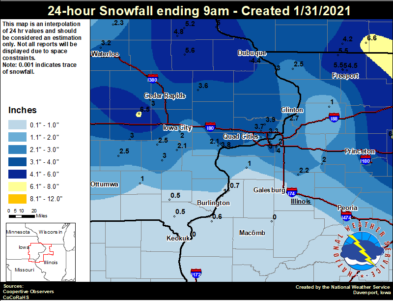
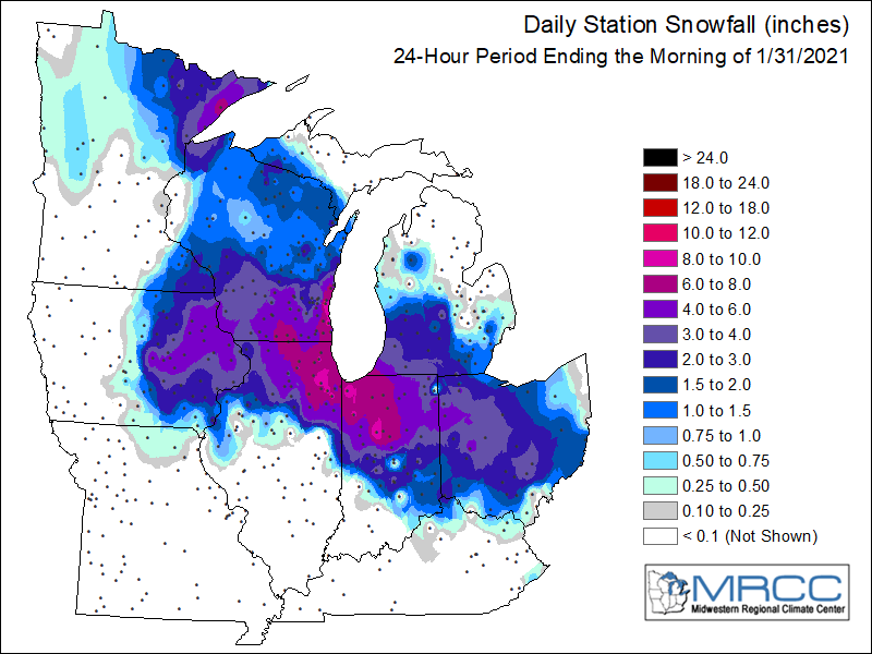
January 30-31 2021 Snow was widespread across the area during the morning of January 31, 2021, and all of eastern Iowa, northwest Illinois and far northeast Missouri saw some form of accumulating snow. Totals were highest in parts of east central Iowa and in north central Illinois, where locally heavy banding at times on the morning of January 31 produced higher snowfall rates. Overall, totals ranged from around 4 to 6 inches, with some locally higher amounts of 7 to 8 inches reported in Buchanan and Benton counties.
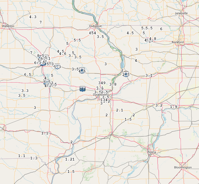
Official National Weather Service Observations
|
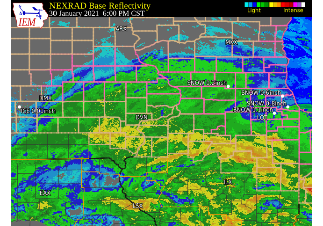
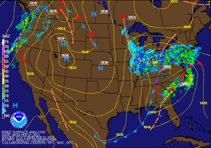 WPC - Surface Map and Radar Loop |
||||||||
Snowfall Amounts
 |
 |
24 hour snow fall in inches,
for eastern Iowa, northwest and west central Illinois,
and northeast Missouri. Reported between 6 AM and 9 AM,
Sunday January 31, 2021.

....IOWA....
Amana 4.7 W                       6.5
Manchester                        5.6
Elkader 6SSW                      5.2
Guttenberg Dam 10                 5.0
Strawberry Point                  4.8
Marshalltown 1 NW                 4.5
Dubuque Arpt                      4.4
Toledo 3 N                        4.0
Fayette 1 NW                      4.0
Park View 0.2 WSW                 3.9
Muscatine 2N                      3.8
Coralville 1.3 SE                 3.7
Davenport Arpt                    3.7
Anamosa 3 SSW                     3.6
Bettendorf 1.6 W                  3.3
Waterloo ASOS                     3.2
North English                     3.0
Washington                        3.0
Bellevue LD12                     3.0
Fairfax 4.0 NW                    3.0
Davenport 0.9 WNW                 2.8
Camanche 1.2 W                    2.7
Wellman 4.0 E                     2.5
Sigourney                         2.5
Tripoli 0 N                       2.3
Muscatine 2.1 N                   2.1
Ainsworth 7.4 N                   2.1
Iowa City                         2.0 (COOP Station)
Fairfield                         1.0
Salem 1S                          0.5
Allerton 2 S                      0.5
Donnellson                        0.5
Hampton 1 N                       0.5
NWS Johnston* 5 NNW               0.2
Boone 1 SSW                       0.0
Perry 0 W                         0.0
Keokuk LD19                       0.0
....ILLINOIS....
Romeoville                        9.5
Mundelein                         7.0
Rockford ASOS                     6.0
Mendota 2 SE                      6.0
Freeport 2.0 NW                   5.5
Winslow 4.3 ESE                   5.5
St Anne                           5.0
Freeport 1.7 NW                   5.0
Freeport                          4.5
Coal Valley 1.9 SE                4.0
Princeton 1.1 SE                  3.2
Princeton                         3.2
Quad City Arpt                    3.0
Moline 0.7 NNE                    2.8
Elizabeth                         2.5
Altona                            2.2
Kewanee 1 E                       2.0
Coal Valley 2.6 E                 2.0
Aledo                             1.0
Gladstone LD18                    1.0
Coleta 1.4 SSW                    1.0
Macomb                            1.0
Oquawka 0.5 N                     0.7
Dallas City 3.0 SSE               0.6
Colchester 3.5 NE                 0.2
Galesburg                         0.0
Prairie City 2S                   0.0
Windsor                           0.0
Ogden                             0.0
Tuscola                           0.0
|
|
Storm Reports
January 30 12AM - February 1 12AM Storm Reports
Courtesy IEM
|
|
PRELIMINARY LOCAL STORM REPORT...SUMMARY
NATIONAL WEATHER SERVICE QUAD CITIES IA IL
229 PM CST SUN JAN 31 2021

..TIME...   ...EVENT...      ...CITY LOCATION...     ...LAT.LON...
..DATE...   ....MAG....      ..COUNTY LOCATION..ST.. ...SOURCE....
            ..REMARKS..

0138 PM     SNOW             3 E STERLING            41.80N 89.64W
01/31/2021  M3.1 INCH        WHITESIDE          IL   TRAINED SPOTTER


1245 PM     SNOW             ORANGEVILLE             42.47N 89.64W
01/31/2021  E5.5 INCH        STEPHENSON         IL   PUBLIC

            SO FAR.

1241 PM     SNOW             DAVENPORT MUNICIPALITY  41.61N 90.58W
01/31/2021  M3.9 INCH        SCOTT              IA   OFFICIAL NWS OBS

            SNOW TOTAL THROUGH NOON; 0.2 INCHES 6 AM TO
            12 PM.

1233 PM     SNOW             WYOMING                 42.06N 91.00W
01/31/2021  M3.5 INCH        JONES              IA   TRAINED SPOTTER


1231 PM     SNOW             2 NNW OAKLAND MILLS     40.97N 91.63W
01/31/2021  M1.1 INCH        HENRY              IA   TRAINED SPOTTER

            EVENT TOTAL SO FAR.

1228 PM     SNOW             2 NW MARION             42.05N 91.61W
01/31/2021  E5.0 INCH        LINN               IA   TRAINED SPOTTER


1200 PM     SNOW             3 SW QUAD CITY AIRPORT  41.40N 90.55W
01/31/2021  M3.0 INCH        ROCK ISLAND        IL   OFFICIAL NWS OBS

            SNOW TOTAL THROUGH NOON; TRACE 6 AM TO 12
            PM.

1200 PM     SNOW             MOLINE QUAD-CITY AIRPOR 41.45N 90.50W
01/31/2021  M3.0 INCH        ROCK ISLAND        IL   OFFICIAL NWS OBS

            A TRACE OF SNOW HAS FALLEN SINCE 6 AM.
            UPDATES PREVIOUS SNOW REPORT FROM MOLINE
            QUAD-CITY AIRPORT. TOTAL THROUGH 6 AM, 1.6
            INCHES SINCE MIDNIGHT.

1200 PM     SNOW             DUBUQUE REGIONAL ARPT   42.40N 90.72W
01/31/2021  M5.0 INCH        DUBUQUE            IA   OFFICIAL NWS OBS

            AN ADDITIONAL 0.6 INCHES HAS FALLEN SINCE
            6AM. UPDATES PREVIOUS SNOW REPORT FROM
            DUBUQUE REGIONAL ARPT. TOTAL THROUGH 6 AM,
            2.1 INCHES SINCE MIDNIGHT.

1200 PM     SNOW             1 NW DUBUQUE REGIONAL A 42.41N 90.73W
01/31/2021  M5.0 INCH        DUBUQUE            IA   OFFICIAL NWS OBS

            TOTAL THROUGH NOON; 0.6 INCHES 6 AM TO 12
            PM.

1146 AM     SNOW             LISBON                  41.92N 91.39W
01/31/2021  M5.3 INCH        LINN               IA   TRAINED SPOTTER

            CORRECTS PREVIOUS OF FREEZING RAIN FROM
            LISBON. STORM TOTAL FOR EVENT.

1132 AM     SNOW             1 SW COAL VALLEY        41.43N 90.45W
01/31/2021  M3.2 INCH        ROCK ISLAND        IL   TRAINED SPOTTER


1118 AM     SNOW             CASCADE                 42.30N 91.01W
01/31/2021  E5.5 INCH        DUBUQUE            IA   PUBLIC

            RELAYED BY BROADCAST MEDIA.

1105 AM     SNOW             LOWDEN                  41.86N 90.92W
01/31/2021  M4.6 INCH        CEDAR              IA   CO-OP OBSERVER

            UPDATES PREVIOUS SNOW REPORT FROM LOWDEN.

1102 AM     SNOW             CHARLOTTE               41.96N 90.47W
01/31/2021  E3.0 INCH        CLINTON            IA   PUBLIC


1101 AM     SNOW             1 NE CEDAR RAPIDS       41.99N 91.65W
01/31/2021  M6.0 INCH        LINN               IA   PUBLIC


1057 AM     SNOW             3 ENE CHARLIE HEATH MEM 40.61N 91.84W
01/31/2021  M1.3 INCH        CLARK              MO   TRAINED SPOTTER


1055 AM     SNOW             3 ENE GARDEN PLAIN      41.81N 90.08W
01/31/2021  E2.5 INCH        WHITESIDE          IL   TRAINED SPOTTER

            ESTIMATING 2-3 INCHES OF SNOW SO FAR.

1055 AM     SNOW             CENTER JUNCTION         42.12N 91.09W
01/31/2021  M5.0 INCH        JONES              IA   PUBLIC


1045 AM     SNOW             4 ENE IOWA CITY         41.67N 91.47W
01/31/2021  M3.5 INCH        JOHNSON            IA   TRAINED SPOTTER

            SO FAR.

1040 AM     SNOW             1 SW UNIVERSITY HEIGHTS 41.65N 91.57W
01/31/2021  M4.2 INCH        JOHNSON            IA   TRAINED SPOTTER

            SO FAR.

1036 AM     SNOW             1 E MOLINE              41.49N 90.47W
01/31/2021  M3.5 INCH        ROCK ISLAND        IL   BROADCAST MEDIA


1035 AM     SNOW             3 SW WINNESHIEK         42.32N 89.57W
01/31/2021  M4.8 INCH        STEPHENSON         IL   TRAINED SPOTTER

            SO FAR.

1018 AM     FREEZING RAIN    DURANT                  41.60N 90.91W
01/31/2021  E0.50 INCH       CEDAR              IA   TRAINED SPOTTER

            HALF AN INCH OF ICE DEPOSITION UNDERNEATH
            THE SNOW.

1015 AM     SNOW             4 N FAIRFAX             41.98N 91.77W
01/31/2021  E6.3 INCH        LINN               IA   PUBLIC


1011 AM     SNOW             MARION                  42.04N 91.59W
01/31/2021  M5.1 INCH        LINN               IA   PUBLIC

            RELAYED BY BROADCAST MEDIA.

1010 AM     SNOW             1 W BETTENDORF          41.56N 90.49W
01/31/2021  M2.5 INCH        SCOTT              IA   TRAINED SPOTTER


1009 AM     SNOW             1 NNE OAKDALE           41.71N 91.59W
01/31/2021  M6.5 INCH        JOHNSON            IA   TRAINED SPOTTER


1008 AM     SNOW             CLARENCE                41.89N 91.05W
01/31/2021  M3.5 INCH        CEDAR              IA   TRAINED SPOTTER


1000 AM     SNOW             CHADWICK                42.01N 89.89W
01/31/2021  M4.0 INCH        CARROLL            IL   TRAINED SPOTTER

            SO FAR.

1000 AM     SNOW             2 SW SAINT DONATUS      42.35N 90.57W
01/31/2021  M3.5 INCH        JACKSON            IA   TRAINED SPOTTER

            SO FAR.

0950 AM     SNOW             PARNELL                 41.58N 92.01W
01/31/2021  M3.3 INCH        IOWA               IA   TRAINED SPOTTER

            SO FAR.

0930 AM     SNOW             BERTRAM                 41.96N 91.53W
01/31/2021  E5.3 INCH        LINN               IA   PUBLIC

            SO FAR.

0930 AM     SNOW             1 SSW HIAWATHA          42.04N 91.69W
01/31/2021  M6.0 INCH        LINN               IA   TRAINED SPOTTER

            SO FAR.

0911 AM     SNOW             WEST CHESTER            41.34N 91.82W
01/31/2021  M3.0 INCH        WASHINGTON         IA   PUBLIC


0910 AM     SNOW             1 SSW CORDOVA           41.67N 90.33W
01/31/2021  M3.8 INCH        ROCK ISLAND        IL   TRAINED SPOTTER

            SO FAR.

0907 AM     SNOW             1 N FREEPORT            42.30N 89.63W
01/31/2021  M5.0 INCH        STEPHENSON         IL   TRAINED SPOTTER

            SO FAR.

0906 AM     SNOW             3 W CEDAR RAPIDS        41.97N 91.73W
01/31/2021  M7.0 INCH        LINN               IA   TRAINED SPOTTER

            SO FAR. SUN TRYING TO PEEK OUT.

0905 AM     SNOW             NORTH ENGLISH           41.51N 92.07W
01/31/2021  M3.5 INCH        IOWA               IA   TRAINED SPOTTER

            SO FAR.

0900 AM     SNOW             FREEPORT                42.28N 89.63W
01/31/2021  M6.0 INCH        STEPHENSON         IL   TRAINED SPOTTER

            SO FAR. 2.5 INCHES SINCE MIDNIGHT.

0900 AM     SNOW             2 NNW NORTH LIBERTY     41.76N 91.62W
01/31/2021  M4.0 INCH        JOHNSON            IA   TRAINED SPOTTER

            SO FAR.

0900 AM     SNOW             5 SW LAMONT             42.55N 91.71W
01/31/2021  M7.0 INCH        BUCHANAN           IA   COCORAHS

            STORM TOTAL SO FAR.

0859 AM     SNOW             2 W MARION              42.04N 91.63W
01/31/2021  M5.1 INCH        LINN               IA   PUBLIC


0857 AM     SNOW             1 SSW KEWANEE           41.23N 89.93W
01/31/2021  E2.0 INCH        HENRY              IL   TRAINED SPOTTER

            SO FAR.

0854 AM     SNOW             ANAMOSA                 42.11N 91.29W
01/31/2021  M4.6 INCH        JONES              IA   TRAINED SPOTTER

            SO FAR.

0853 AM     SNOW             1 ENE MOUNT VERNON      41.93N 91.41W
01/31/2021  M4.5 INCH        LINN               IA   TRAINED SPOTTER

            SO FAR.

0845 AM     SNOW             1 NW DAVENPORT          41.56N 90.62W
01/31/2021  M3.5 INCH        SCOTT              IA   TRAINED SPOTTER

            SO FAR.

0845 AM     SNOW             UNIVERSITY HEIGHTS      41.65N 91.55W
01/31/2021  M3.0 INCH        JOHNSON            IA   TRAINED SPOTTER

            SO FAR.

0844 AM     SNOW             2 SSW HIAWATHA          42.02N 91.70W
01/31/2021  M5.9 INCH        LINN               IA   TRAINED SPOTTER

            AVERAGED SNOWFALL.

0833 AM     SNOW             CAMBRIDGE               41.30N 90.20W
01/31/2021  M2.1 INCH        HENRY              IL   TRAINED SPOTTER

            SO FAR.

0829 AM     SNOW             PARK VIEW               41.69N 90.54W
01/31/2021  M4.0 INCH        SCOTT              IA   NWS EMPLOYEE

            CORRECTS PREVIOUS FREEZING RAIN TO SNOW
            REPORT FROM PARK VIEW. STILL SNOWING, 14
            INCH SNOW DEPTH.

0828 AM     SNOW             3 N STOCKTON            42.40N 90.00W
01/31/2021  M4.5 INCH        JO DAVIESS         IL   CO-OP OBSERVER

            SO FAR. SNOW DEPTH IS 15 INCHES.

0825 AM     SNOW             1 NNW MONTICELLO        42.25N 91.20W
01/31/2021  M5.0 INCH        JONES              IA   TRAINED SPOTTER

            SO FAR.

0824 AM     SNOW             3 SW CENTER JUNCTION    42.08N 91.11W
01/31/2021  M3.7 INCH        JONES              IA   PUBLIC


0824 AM     SNOW             2 NNE STONE CITY        42.14N 91.33W
01/31/2021  M4.5 INCH        JONES              IA   TRAINED SPOTTER

            SO FAR.

0809 AM     SNOW             2 S MC CONNELL          42.40N 89.74W
01/31/2021  M5.0 INCH        STEPHENSON         IL   TRAINED SPOTTER

            SO FAR.

0802 AM     SNOW             2 E HIAWATHA            42.05N 91.64W
01/31/2021  M4.5 INCH        LINN               IA   TRAINED SPOTTER


0800 AM     SNOW             1 SSW NORTH LIBERTY     41.73N 91.62W
01/31/2021  M4.0 INCH        JOHNSON            IA   TRAINED SPOTTER

            SO FAR.

0800 AM     SNOW             2 N BURLINGTON          40.84N 91.12W
01/31/2021  M2.0 INCH        DES MOINES         IA   TRAINED SPOTTER

            SO FAR.

0759 AM     SNOW             GALVA                   41.17N 90.04W
01/31/2021  E1.5 INCH        HENRY              IL   PUBLIC

            SO FAR.

0730 AM     SNOW             2 W CEDAR RAPIDS        41.98N 91.71W
01/31/2021  M6.4 INCH        LINN               IA   TRAINED SPOTTER

            UPDATES PREVIOUS SNOW REPORT FROM 2 W CEDAR
            RAPIDS. SO FAR. STILL SNOWING.

0730 AM     SNOW             SOLON                   41.80N 91.49W
01/31/2021  M5.0 INCH        JOHNSON            IA   TRAINED SPOTTER

            SO FAR.

0728 AM     SNOW             3 NW CEDAR RAPIDS       42.01N 91.71W
01/31/2021  E6.0 INCH        LINN               IA   PUBLIC

            RELAYED BY BROADCAST MEDIA.

0722 AM     SNOW             NE IOWA CITY            41.69N 91.49W
01/31/2021  E3.0 INCH        JOHNSON            IA   PUBLIC

            STILL SNOWING.

0714 AM     HEAVY RAIN       CARTHAGE                40.41N 91.13W
01/31/2021  M1.50 INCH       HANCOCK            IL   TRAINED SPOTTER

            24 HOUR TOTAL.

0708 AM     SNOW             IOWA CITY               41.66N 91.54W
01/31/2021  E3.3 INCH        JOHNSON            IA   PUBLIC

            SO FAR.

0700 AM     SNOW             3 NNE MC CONNELL        42.47N 89.72W
01/31/2021  M5.5 INCH        STEPHENSON         IL   COCORAHS

            STORM TOTAL SO FAR.

0700 AM     SNOW             3 N DAVIS               42.46N 89.41W
01/31/2021  M6.0 INCH        STEPHENSON         IL   COCORAHS

            STORM TOTAL SO FAR.

0700 AM     SNOW             2 E GRIFFIN             41.23N 90.45W
01/31/2021  E2.0 INCH        MERCER             IL   PUBLIC


0700 AM     HEAVY RAIN       2 NE COLUSA             40.59N 91.15W
01/31/2021  M1.21 INCH       HANCOCK            IL   TRAINED SPOTTER


0700 AM     SNOW             1 SE PRINCETON          41.37N 89.45W
01/31/2021  M3.2 INCH        BUREAU             IL   COCORAHS

            STORM TOTAL SO FAR.

0700 AM     SNOW             3 NNE CEDAR RAPIDS      42.01N 91.66W
01/31/2021  M5.8 INCH        LINN               IA   TRAINED SPOTTER

            UPDATES PREVIOUS SNOW REPORT FROM 3 NNE
            CEDAR RAPIDS. SO FAR.

0700 AM     SNOW             1 NNE WEST AMANA        41.81N 91.96W
01/31/2021  M6.5 INCH        IOWA               IA   COCORAHS

            STORM TOTAL SO FAR.

0645 AM     SNOW             2 W BETTENDORF          41.57N 90.51W
01/31/2021  M3.3 INCH        SCOTT              IA   NWS EMPLOYEE

            SLR 9:1. 0.2 INCHES OF TOTAL WAS SLEET.
            LIGHT SNOW FALLING AT OBSERVATION.

0643 AM     SNOW             1 ESE DALZELL           41.35N 89.17W
01/31/2021  M1.9 INCH        BUREAU             IL   TRAINED SPOTTER


0608 AM     SNOW             2 WNW FREEPORT          42.30N 89.66W
01/31/2021  M4.8 INCH        STEPHENSON         IL   TRAINED SPOTTER

            SNOW STILL FALLING.
|
|
|
 |
Media use of NWS Web News Stories is encouraged! Please acknowledge the NWS as the source of any news information accessed from this site. |
|