A significant heat wave is underway for the Intermountain West, Northern Plains, and Upper Great Lakes, peaking in intensity through midweek and lingering across parts of the Northern Plains and Midwest until this weekend. In southwest Texas, excessive rainfall may bring a risk for potentially life-threatening flash and arroyo flooding through Thursday. Read More >
|
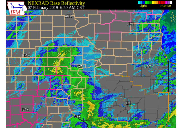
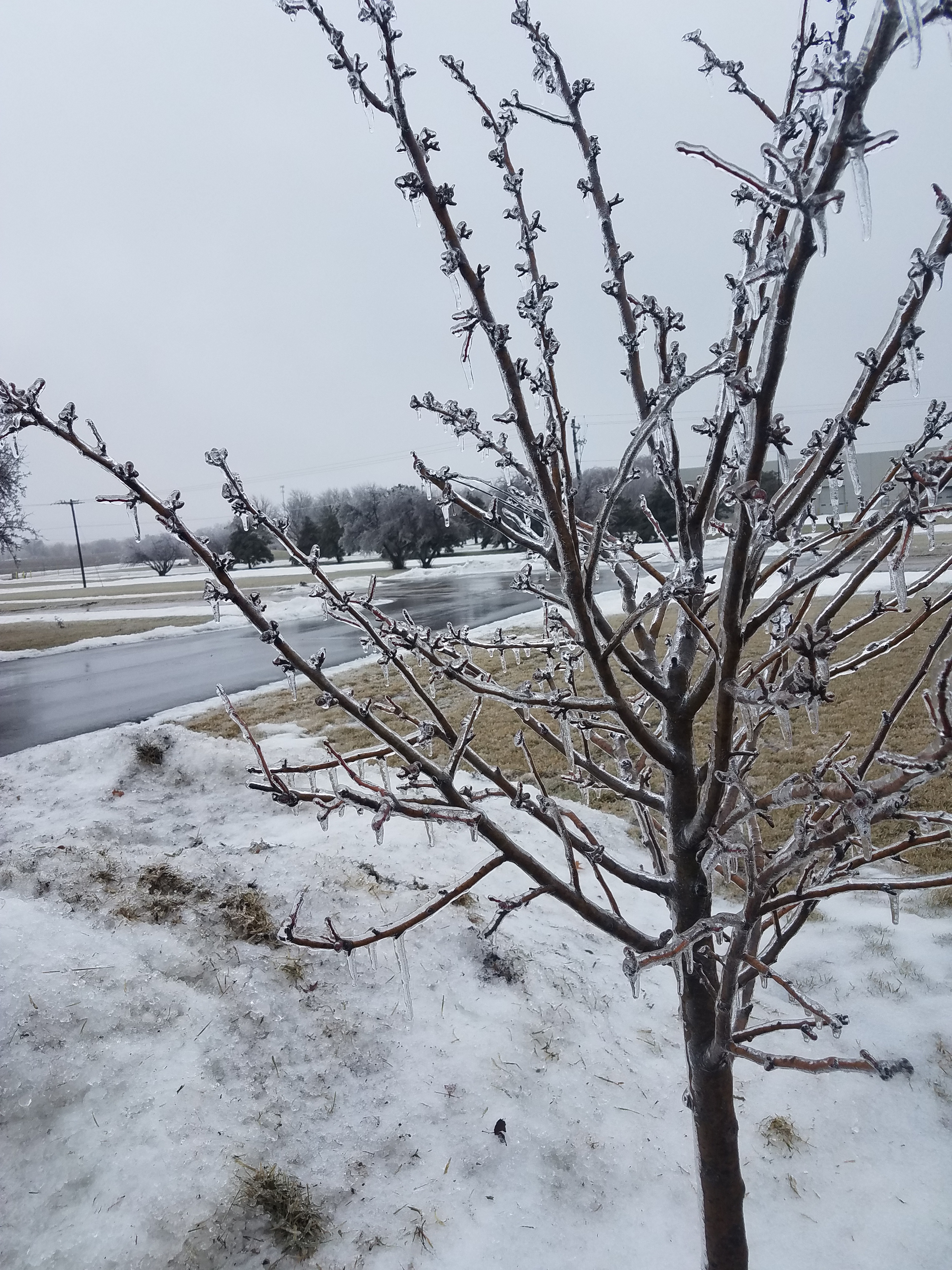
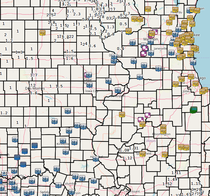
A winter storm brought widespread freezing rain, sleet, and rain to the region Thursday morning (Feb. 7) across eastern Iowa, northwest Illinois, and northeast Missouri. This event fell on the heels of another freezing rain event on Feb. 5-6. Slick roads, driveways, and sidewalks were common with numerous accidents on major highways. Ice accumulations between a tenth and two tenths of an inch were common. Some higher ice amounts were reported in Stephenson county in Illinois. Strong winds and cold air were found behind this storm with winds gusting between 35 and 50 mph. This caused many tree limbs to fall due to the weight of ice on them. Wind chills also dropped down into the -15 to -25 degree range late Thursday and early Friday. |
 NWS OFFICE - DAVENPORT, IA |
Wind Gusts:
PUBLIC INFORMATION STATEMENT
NATIONAL WEATHER SERVICE QUAD CITIES IA IL
653 AM CST FRI FEB 8 2019

...HIGHEST WIND GUSTS PAST 24 HOURS...

OBSERVATIONS ARE COLLECTED FROM A VARIETY OF SOURCES WITH VARYING
EQUIPMENT AND EXPOSURES. WE THANK ALL VOLUNTEER WEATHER OBSERVERS
FOR THEIR DEDICATION. NOT ALL DATA LISTED ARE CONSIDERED OFFICIAL.

LOCATION                     SPEED     TIME/DATE       LAT/LON
QUAD CITY INTL ARPT          53 MPH    0646 PM 02/07   41.45N/90.51W
CLINTON ARPT                 51 MPH    0659 PM 02/07   41.83N/90.33W
DAVENPORT ARPT               49 MPH    0631 PM 02/07   41.61N/90.59W
2 NW MOLINE                  49 MPH    0800 PM 02/07   41.52N/90.51W
STERLING/ROCK FALLS ARPT     49 MPH    0702 PM 02/07   41.74N/89.67W
IOWA CITY ARPT               47 MPH    1039 PM 02/07   41.64N/91.55W
CEDAR RAPIDS ARPT            46 MPH    0749 PM 02/07   41.88N/91.71W
DUBUQUE ARPT                 45 MPH    1108 PM 02/07   42.40N/90.71W
MUSCATINE ARPT               45 MPH    0615 PM 02/07   41.37N/91.15W
FULTON L/D 13                44 MPH    0430 AM 02/08   41.92N/90.15W
WASHINGTON ARPT              43 MPH    0815 PM 02/07   41.28N/91.67W
FAIRFIELD ARPT               43 MPH    0235 PM 02/07   41.05N/91.98W
UNION GROVE                  41 MPH    0700 PM 02/07   41.84N/90.04W
INDEPENDENCE ARPT            40 MPH    0215 AM 02/08   42.45N/91.95W
MACOMB ARPT                  40 MPH    1235 PM 02/07   40.52N/90.65W
2 WNW PALISADES STATE PARK   40 MPH    0640 PM 02/07   41.93N/91.55W
CENTER GROVE                 40 MPH    1035 PM 02/07   42.49N/90.73W
VINTON ARPT                  40 MPH    0915 PM 02/07   42.23N/92.03W
BURLINGTON ARPT              39 MPH    1146 AM 02/07   40.78N/91.13W
1 E BRANDON                  39 MPH    0944 PM 02/07   42.31N/91.98W
KEOKUK ARPT                  38 MPH    0755 PM 02/07   40.46N/91.43W
1 W DEWITT                   37 MPH    0355 AM 02/08   41.83N/90.57W
2 W LIME CITY                37 MPH    0720 PM 02/07   41.65N/91.13W
1 NNE CANTRIL                34 MPH    1110 PM 02/07   40.66N/92.06W
LE CLAIRE L/D 14             34 MPH    0630 PM 02/07   41.58N/90.42W
NEW BOSTON L/D 17            34 MPH    1120 PM 02/07   41.18N/91.05W
GLADSTONE L/D 18             33 MPH    0220 PM 02/07   40.88N/91.03W
ILLINOIS CITY L/D 16         33 MPH    0500 PM 02/07   41.42N/91.02W
CEDAR RAPIDS                 33 MPH    0820 PM 02/07   41.98N/91.67W
ROCK ISLAND L/D 15           33 MPH    0710 PM 02/07   41.52N/90.57W
3 SSW CEDAR RAPIDS           32 MPH    0750 PM 02/07   41.93N/91.68W
LOW MOOR                     32 MPH    1225 AM 02/08   41.80N/90.35W
FORT MADISON ARPT            29 MPH    0155 AM 02/08   40.66N/91.33W
MOUNT PLEASANT ARPT          29 MPH    0615 PM 02/07   40.95N/91.51W
GULFPORT                     29 MPH    0700 PM 02/07   40.81N/91.10W
GALT                         29 MPH    0620 PM 02/07   41.79N/89.77W
Wind Chills
PUBLIC INFORMATION STATEMENT
NATIONAL WEATHER SERVICE QUAD CITIES IA IL
938 AM CST FRI FEB 8 2019

...LOWEST WIND CHILL REPORTS PAST 12 HOURS...

OBSERVATIONS ARE COLLECTED FROM A VARIETY OF SOURCES WITH VARYING
EQUIPMENT AND EXPOSURES. WE THANK ALL VOLUNTEER WEATHER OBSERVERS
FOR THEIR DEDICATION. NOT ALL DATA LISTED ARE CONSIDERED OFFICIAL.

LOCATION                     TEMP      TIME/DATE       LAT/LON
CEDAR RAPIDS ARPT            -28 F     0442 AM 02/08   41.88N/91.71W
DUBUQUE ARPT                 -28 F     0553 AM 02/08   42.40N/90.71W
2 WNW PALISADES STATE PARK   -28 F     0520 AM 02/08   41.93N/91.55W
VINTON ARPT                  -28 F     0715 AM 02/08   42.23N/92.03W
INDEPENDENCE ARPT            -26 F     0215 AM 02/08   42.45N/91.95W
CLINTON ARPT                 -25 F     0556 AM 02/08   41.83N/90.33W
1 E BRANDON                  -25 F     0524 AM 02/08   42.31N/91.98W
STERLING/ROCK FALLS ARPT     -25 F     0627 AM 02/08   41.74N/89.67W
3 SSW CEDAR RAPIDS           -24 F     0630 AM 02/08   41.93N/91.68W
CENTER GROVE                 -24 F     0706 AM 02/08   42.49N/90.73W
1 W DEWITT                   -24 F     0715 AM 02/08   41.83N/90.57W
DAVENPORT ARPT               -23 F     0612 AM 02/08   41.61N/90.59W
2 NW MOLINE                  -23 F     0550 AM 02/08   41.52N/90.51W
IOWA CITY ARPT               -23 F     0503 AM 02/08   41.64N/91.55W
LOW MOOR                     -23 F     1225 AM 02/08   41.80N/90.35W
WASHINGTON ARPT              -22 F     0515 AM 02/08   41.28N/91.67W
MECHANICSVILLE               -22 F     0230 AM 02/08   41.90N/91.26W
BELLE PLAINE                 -22 F     0330 AM 02/08   41.90N/92.29W
FAIRFIELD ARPT               -21 F     0615 AM 02/08   41.05N/91.98W
FULTON L/D 13                -21 F     0800 AM 02/08   41.92N/90.15W
MUSCATINE ARPT               -21 F     0715 AM 02/08   41.37N/91.15W
CEDAR RAPIDS                 -21 F     0830 AM 02/08   41.98N/91.67W
2 W LIME CITY                -21 F     0850 AM 02/08   41.65N/91.13W
2 W UNIVERSITY HEIGHTS       -20 F     0702 AM 02/08   41.66N/91.60W
1 SSE MANCHESTER             -20 F     0643 AM 02/08   42.47N/91.45W
QUAD CITY INTL ARPT          -19 F     0652 AM 02/08   41.45N/90.51W
NEW BOSTON L/D 17            -19 F     0740 AM 02/08   41.18N/91.05W
2 W BERTRAM                  -19 F     0300 AM 02/08   41.96N/91.59W
GALT                         -19 F     0715 AM 02/08   41.79N/89.77W
1 N WILLIAMSBURG             -18 F     0800 AM 02/08   41.69N/92.01W
UNION GROVE                  -18 F     0640 AM 02/08   41.84N/90.04W
FORT MADISON ARPT            -17 F     0635 AM 02/08   40.66N/91.33W
GLADSTONE L/D 18             -17 F     0830 AM 02/08   40.88N/91.03W
LE CLAIRE L/D 14             -17 F     0800 AM 02/08   41.58N/90.42W
ROCK ISLAND L/D 15           -17 F     0420 AM 02/08   41.52N/90.57W
CORALVILLE DAM               -16 F     0900 AM 02/08   41.72N/91.53W
DUBUQUE L/D 11               -16 F     0740 AM 02/08   42.54N/90.65W
1 NNE CANTRIL                -16 F     0730 AM 02/08   40.66N/92.06W
ILLINOIS CITY L/D 16         -16 F     0820 AM 02/08   41.42N/91.02W
SAVANNA ARPT                 -16 F     0657 AM 02/08   42.05N/90.11W
BURLINGTON ARPT              -15 F     0753 AM 02/08   40.78N/91.13W
KEOKUK ARPT                  -15 F     0655 AM 02/08   40.46N/91.43W
MACOMB ARPT                  -15 F     0735 AM 02/08   40.52N/90.65W
MOUNT PLEASANT ARPT          -14 F     0755 AM 02/08   40.95N/91.51W
 |
PRELIMINARY LOCAL STORM REPORT
NATIONAL WEATHER SERVICE QUAD CITIES IA IL
1043 AM CST FRI FEB 8 2019

..TIME...   ...EVENT...      ...CITY LOCATION...     ...LAT.LON...
..DATE...   ....MAG....      ..COUNTY LOCATION..ST.. ...SOURCE....
            ..REMARKS..

1031 AM     FREEZING RAIN    3 ESE HIAWATHA          42.03N 91.64W
02/07/2019  M0.10 INCH       LINN               IA   BROADCAST MEDIA


1013 AM     FREEZING RAIN    DAVENPORT AIRPORT       41.61N 90.58W
02/07/2019  M0.20 INCH       SCOTT              IA   OFFICIAL NWS OBS

            MEASURED ON TREE BRANCHES.

0937 AM     FREEZING RAIN    FREEPORT                42.29N 89.63W
02/07/2019  E0.40 INCH       STEPHENSON         IL   EMERGENCY MNGR

            QUARTER TO FOUR TENTHS OF ICE SINCE LAST
            NIGHT. A LOT OF SCHOOLS AND BUSINESSES
            CLOSED.

0930 AM     FREEZING RAIN    2 NNW NORTH LIBERTY     41.76N 91.62W
02/07/2019  E0.20 INCH       JOHNSON            IA   TRAINED SPOTTER


0917 AM     FREEZING RAIN    2 WNW DUBUQUE           42.52N 90.72W
02/07/2019  M0.20 INCH       DUBUQUE            IA   TRAINED SPOTTER

            MEASURED ON BRANCH, SECONDARY ROADS AND
            SIDEWALKS SLICK.

0815 AM     FREEZING RAIN    MILLEDGEVILLE           41.97N 89.78W
02/07/2019  M0.10 INCH       CARROLL            IL   TRAINED SPOTTER


0748 AM     FREEZING RAIN    DAVENPORT AIRPORT       41.61N 90.58W
02/07/2019  E0.10 INCH       SCOTT              IA   OFFICIAL NWS OBS

            VERY SLICK PARKING LOT AND SIDEWALKS.

0745 AM     FREEZING RAIN    3 N STOCKTON            42.40N 90.00W
02/07/2019  M0.20 INCH       JO DAVIESS         IL   CO-OP OBSERVER

            VERY SLICK ROADS.

0625 AM     FREEZING RAIN    1 WNW DUBUQUE REGIONAL  42.41N 90.73W
02/07/2019  M0.10 INCH       DUBUQUE            IA   CO-OP OBSERVER


0511 AM     FREEZING RAIN    3 ENE CHARLIE HEATH MEM 40.61N 91.84W
02/07/2019  M0.13 INCH       CLARK              MO   TRAINED SPOTTER

            1/8 INCH OF ICE ON TREE BRANCHES.

0527 PM     FREEZING RAIN    3 NE CHARLIE HEATH MEMO 40.61N 91.84W
02/06/2019  E0.01 INCH       CLARK              MO   TRAINED SPOTTER

            MAINLY FREEZING DRIZZLE WHICH IS BEGINNING
            TO STICK ON SURFACES.

0527 PM     FREEZING RAIN    1 N LOWDEN              41.87N 90.92W
02/06/2019  M0.07 INCH       CEDAR              IA   PUBLIC

            TEMPERATURE IS 30 DEGREES AND THINGS ARE
            GETTING SLICK.
|
Environment
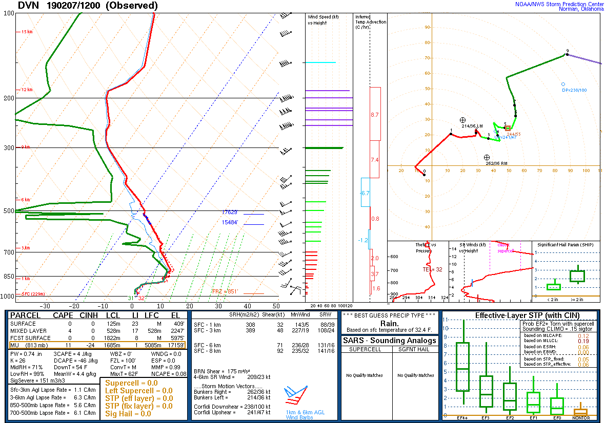 |
| Figure 1: DVN Sounding 02/07/2019 12z |
 |
Media use of NWS Web News Stories is encouraged! Please acknowledge the NWS as the source of any news information accessed from this site. |
|