Scattered thunderstorms with severe gusts, hail and a tornado risk are possible near a cold front from the Ohio Valley to the Mid-Atlantic tonight. Tropical Storm Bertha is expected to bring tropical storm conditions to portions of the Gulf Coast from the panhandle of Florida into Louisiana through Wednesday. Read More >
Overview
|
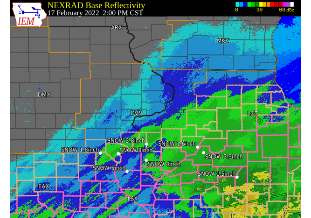
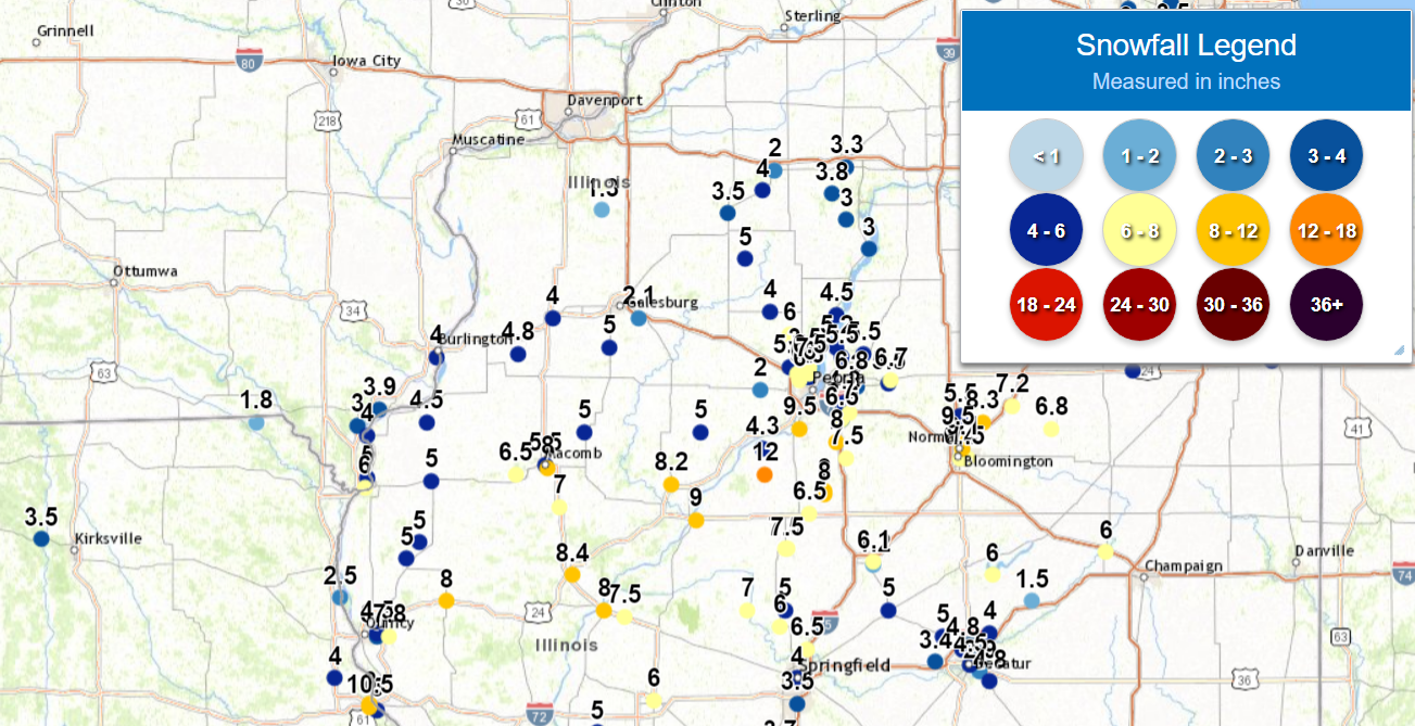
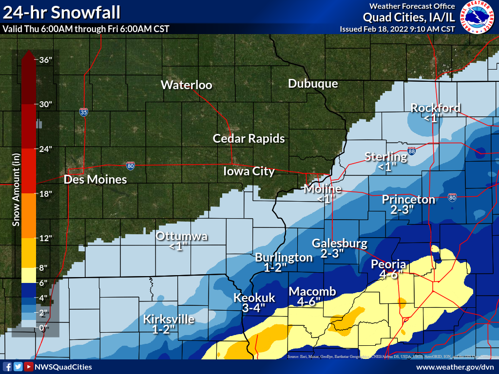
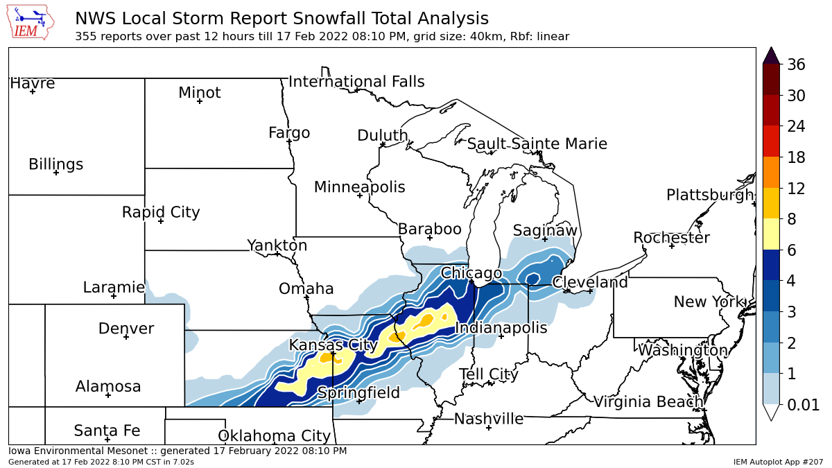
A winter storm brought a mix of precipitation to all of eastern Iowa, northwest Illinois and far northeast Missouri beginning on the evening of Feb 16, and ending on the late afternoon of Feb 17. Areas observed rain at first, but saw a transition over to snow by the morning of Feb 17. Snow amounts of 3 to 6 inches were measured on the evening of Feb 17, and were most prevalent in far northeast Missouri and west central Illinois. A few amounts of 7 to 8 inches were observed over far southern McDonough and Hancock counties in Illinois, where snow bands persisted longer. Snow totals decreased to the north and west, where dry air aloft prevented much in the way of northward progression of snow.
Official National Weather Service Observations
|
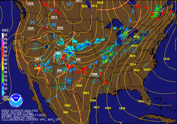 WPC - Surface Map and Radar Loop |
Snowfall Amounts
| Local Snowfall Analysis | Regional Snowfall Analysis (IEM) |
 |
 |
| Regional Snowfall Analysis (Midwest Regional Climate Center) |
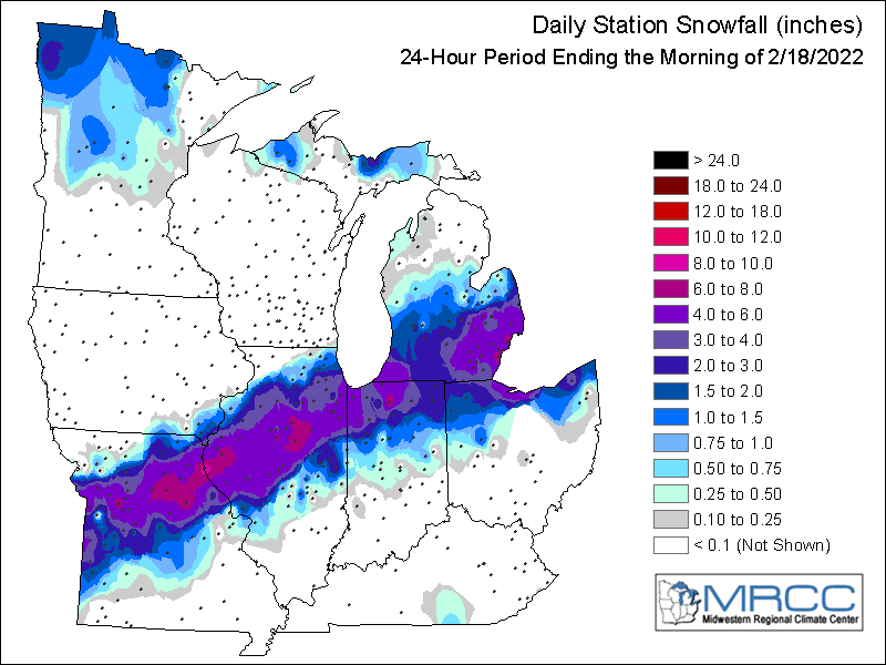 |
24 hour snow fall in inches,
for eastern Iowa, northwest and west central Illinois,
and northeast Missouri. Reported between Midnight and 9 AM,
Friday February 18, 2022.

....IOWA....
Keokuk LD19                       4.0
Donnellson                        1.5
Salem 1S                          1.0
Wapello 5.4 SE                    0.5
Bettendorf 1.6 W                  0.0
Park View 0.2 WSW                 0.0
Le Claire 1.8 NNE                 0.0
Davenport Arpt                    0.0
Keosauqua                         0.0
Muscatine 2N                      0.0
West Liberty 0.7 NNW              0.0
Wellman 4.0 E                     0.0
Ainsworth 7.4 N                   0.0
Davenport 0.9 WNW                 0.0
Camanche 1.2 W                    0.0
Charlotte 1.9 WNW                 0.0
Solon 0.3 ESE                     0.0
Marengo 2.6 SSW                   0.0
Marengo 3.6 N                     0.0
Parnell 0.1 SSW                   0.0
Center Junction 2.6 W             0.0
Central City 6.7 W                0.0
Ely 0.5 SE                        0.0
Center Point 0.6 NNW              0.0
Marion 1.7 NNW                    0.0
Fairfax 4.0 NW                    0.0
Mount Auburn 2.2 NNW              0.0
Hopkinton 5.4 WSW                 0.0
Waterloo Arpt                     0.0
Dubuque #3 7 SW                   0.0
Fairfield                         0.0
Hampton 1 N                       0.0
Oskaloosa 1 NNW                   0.0
Fayette 1 NW                      0.0
Maquoketa                         0.0
Marengo                           0.0
Williamsburg                      0.0
Elkader 6SSW                      0.0
Guttenberg Dam 10                 0.0
Anamosa 3 SSW                     0.0
Strawberry Point                  0.0
NWS Johnston* 5 NNW               0.0
Iowa City                         0.0
Dubuque Arpt                      0.0
Bellevue LD12                     0.0

....ILLINOIS....
Augusta                           8.0
Minonk                            7.0
Warsaw 5.8 SE                     5.6
Prairie City 2S                   5.0
Dallas City 3.0 SSE               4.5
St Anne                           4.5
Bentley                           4.3
Romeoville                        4.1
Rockford Arpt                     3.8
Stronghurst 0.4 SSW               3.7
Kewanee 1 E                       3.6
Jacksonville 2E                   3.5
Colchester 3.5 NE                 3.0
Galesburg                         3.0
Paw Paw 1 E                       2.5
Ogden                             2.4
Ottawa 4 SW                       2.0
New Windsor 2.0 N                 1.3
Mundelein                         1.3
Gladstone LD18                    1.0
Aledo                             0.8
Tuscola                           0.7
Geneseo 2.0 NW                    0.5
Coal Valley 1.9 SE                0.5
Steward                           0.4
Windsor                           0.3
Quad City Arpt                    0.3
Moline 0.7 NNE                    0.2
Davis 0.5 N                       0.0
Freeport 2.9 WSW                  0.0
Freeport 1.7 NW                   0.0
Stockton 3.4 NNE                  0.0
Elizabeth                         0.0
Freeport                          0.0
Mount Carroll                     0.0

....MISSOURI....
Memphis                           1.0
Columbia Arpt                     0.0

....WISCONSIN....
Delavan-1 W-WWTP 1 W              0.0
Monroe 1 W                        0.0
Madison Arpt                      0.0
La Crosse WFO                     0.0
Steuben 4SE 3 NE                  0.0
Brodhead 1 SW                     0.0
Darlington                        0.0
Beloit-College                    0.0
Viroqua                           0.0
Storm Reports
February 17 1200am - February 18 1200am Storm Reports
Courtesy IEM
|
|
PRELIMINARY LOCAL STORM REPORT...SUMMARY
NATIONAL WEATHER SERVICE QUAD CITIES IA IL
907 PM CST THU FEB 17 2022

..TIME...   ...EVENT...      ...CITY LOCATION...     ...LAT.LON...
..DATE...   ....MAG....      ..COUNTY LOCATION..ST.. ...SOURCE....
            ..REMARKS..

0745 PM     SNOW             2 NNE COLUSA            40.59N 91.15W
02/17/2022  E4.5 INCH        HANCOCK            IL   TRAINED SPOTTER


0741 PM     SNOW             1 SE MACOMB             40.46N 90.67W
02/17/2022  M5.5 INCH        MCDONOUGH          IL   EMERGENCY MNGR

            EVENT TOTAL.

0739 PM     SNOW             NEPONSET                41.30N 89.79W
02/17/2022  M4.0 INCH        BUREAU             IL   BROADCAST MEDIA

            REPORT RELAYED BY BROADCAST MEDIA.

0709 PM     SNOW             2 NE LONE TREE CORNERS  41.21N 89.45W
02/17/2022  M3.0 INCH        PUTNAM             IL   AMATEUR RADIO

            ALSO 1.16 OF LIQUID.

0620 PM     HEAVY SNOW       1 S KEOKUK              40.39N 91.40W
02/17/2022  M6.0 INCH        LEE                IA   PUBLIC

            EVENT TOTAL.

0619 PM     SNOW             2 N NEW WINDSOR         41.24N 90.44W
02/17/2022  M1.3 INCH        HENRY              IL   TRAINED SPOTTER

            EVENT TOTAL.

0557 PM     SNOW             MONMOUTH                40.91N 90.64W
02/17/2022  M4.0 INCH        WARREN             IL   PUBLIC


0555 PM     SNOW             SHEFFIELD               41.36N 89.74W
02/17/2022  M2.0 INCH        BUREAU             IL   PUBLIC


0527 PM     SNOW             BUSHNELL                40.56N 90.51W
02/17/2022  M5.0 INCH        MCDONOUGH          IL   TRAINED SPOTTER

            AVERAGE WITH CONSIDERABLE DRIFTING. SWE
            0.35.

0520 PM     SNOW             1 SSW KEWANEE           41.23N 89.93W
02/17/2022  M3.5 INCH        HENRY              IL   TRAINED SPOTTER

            CONSIDERABLE BLOWING SNOW.

0508 PM     SNOW             SMITHSHIRE              40.80N 90.78W
02/17/2022  M4.8 INCH        WARREN             IL   PUBLIC


0500 PM     SNOW             1 NE KEOKUK             40.42N 91.39W
02/17/2022  M5.0 INCH        LEE                IA   TRAINED SPOTTER


0454 PM     HEAVY SNOW       CARTHAGE                40.41N 91.13W
02/17/2022  E5.0 INCH        HANCOCK            IL   TRAINED SPOTTER

            AVERAGE OF 5 MEASUREMENTS.

0446 PM     HEAVY SNOW       1 SSW MOOAR             40.44N 91.45W
02/17/2022  E6.0 INCH        LEE                IA   TRAINED SPOTTER


0444 PM     HEAVY SNOW       2 SE MACOMB             40.45N 90.66W
02/17/2022  M8.0 INCH        MCDONOUGH          IL   TRAINED SPOTTER

            RANGE OF MEASUREMENTS WITH AN AVERAGE AROUND
            8 INCHES.

0433 PM     HEAVY SNOW       COLCHESTER              40.43N 90.79W
02/17/2022  M6.5 INCH        MCDONOUGH          IL   TRAINED SPOTTER


0431 PM     HEAVY SNOW       INDUSTRY                40.33N 90.61W
02/17/2022  M7.0 INCH        MCDONOUGH          IL   TRAINED SPOTTER

            SNOW BEGINNING TO TAPER TO FLURRIES.

0416 PM     SNOW             TISKILWA                41.29N 89.51W
02/17/2022  M3.8 INCH        BUREAU             IL   PUBLIC

            SNOW TOTAL SO FAR.

0412 PM     SNOW             NAUVOO                  40.55N 91.39W
02/17/2022  M4.0 INCH        HANCOCK            IL   PUBLIC


0412 PM     SNOW             1 NE FORT MADISON       40.63N 91.34W
02/17/2022  M3.9 INCH        LEE                IA   PUBLIC

            EVENT TOTAL.

0400 PM     SNOW             1 ENE BURLINGTON REGION 40.79N 91.11W
02/17/2022  M4.0 INCH        DES MOINES         IA   TRAINED SPOTTER

            SNOW HAS TURNED MORE TO FLURRIES.

0345 PM     SNOW             1 SE PRINCETON          41.37N 89.45W
02/17/2022  M3.3 INCH        BUREAU             IL   CO-OP OBSERVER

            TOTAL AS OF 345P.

0254 PM     SNOW             STILLWELL               40.22N 91.18W
02/17/2022  M5.0 INCH        HANCOCK            IL   EMERGENCY MNGR

            CURRENT SNOWFALL, STILL SNOWING. SOME
            DRIFTING BEING SEEN.

0236 PM     SNOW             2 NNE COLUSA            40.59N 91.15W
02/17/2022  M3.5 INCH        HANCOCK            IL   TRAINED SPOTTER


0159 PM     SNOW             3 ENE CHARLIE HEATH MEM 40.59N 91.84W
02/17/2022  M1.8 INCH        CLARK              MO   TRAINED SPOTTER


0150 PM     SNOW             SMITHSHIRE              40.80N 90.78W
02/17/2022  M2.8 INCH        WARREN             IL   PUBLIC

            STILL SNOWING...VIA TWITTER.

0149 PM     SNOW             COLCHESTER              40.43N 90.79W
02/17/2022  M4.0 INCH        MCDONOUGH          IL   TRAINED SPOTTER

            SNOWFALL SO FAR, AVERAGED WITH DEEPER
            DRIFTS.

0145 PM     SNOW             3 NNW BLUFF PARK        40.58N 91.43W
02/17/2022  E3.0 INCH        LEE                IA   PUBLIC
|
|
|
 |
Media use of NWS Web News Stories is encouraged! Please acknowledge the NWS as the source of any news information accessed from this site. |
|