Winter Storm Overview
|
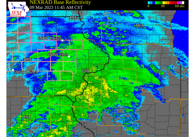
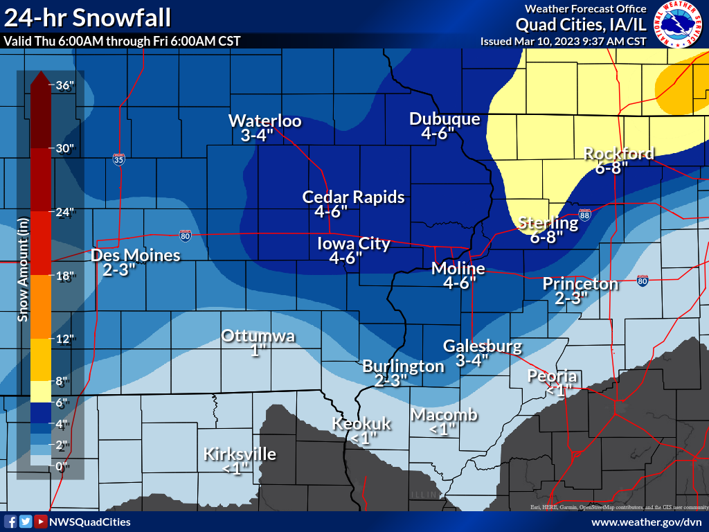
A winter storm brought light to moderate snow to much of eastern Iowa and northwest Illinois on March 9th, 2023. Precipitation began as a mix of rain and snow as it overspread the region during the morning hours. Snow was observed mainly north of Highway 34 to start, with more of a rain, snow and sleet mix to the south. As the day progressed, precipitation began to change to all snow as temperatures dropped. This snow continued for most well into the early evening before tapering off by midnight. Snow totals were highest along and north of Interstate 80 with a range of around 4 - 6 inches. Pockets of higher amounts were observed in northwest Illinois in Stephenson County, with the highest total so far measured just west of Freeport at 6.5 inches. Further south, amounts were less with more rain and sleet mixing with the snow.
NWS Official Totals Moline: 2.5"
Notable (Non-NWS Official) Totals 2 W Freeport, IL: 6.5" (Trained Spotter)
|
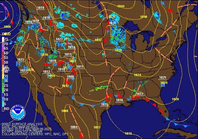 Weather Prediction Center Surface Analysis/Fronts/Radar Loop |
â„ï¸ Snowfall Maps (will be updated Friday AM) â„ï¸
| Friday AM Local Snowfall Map |
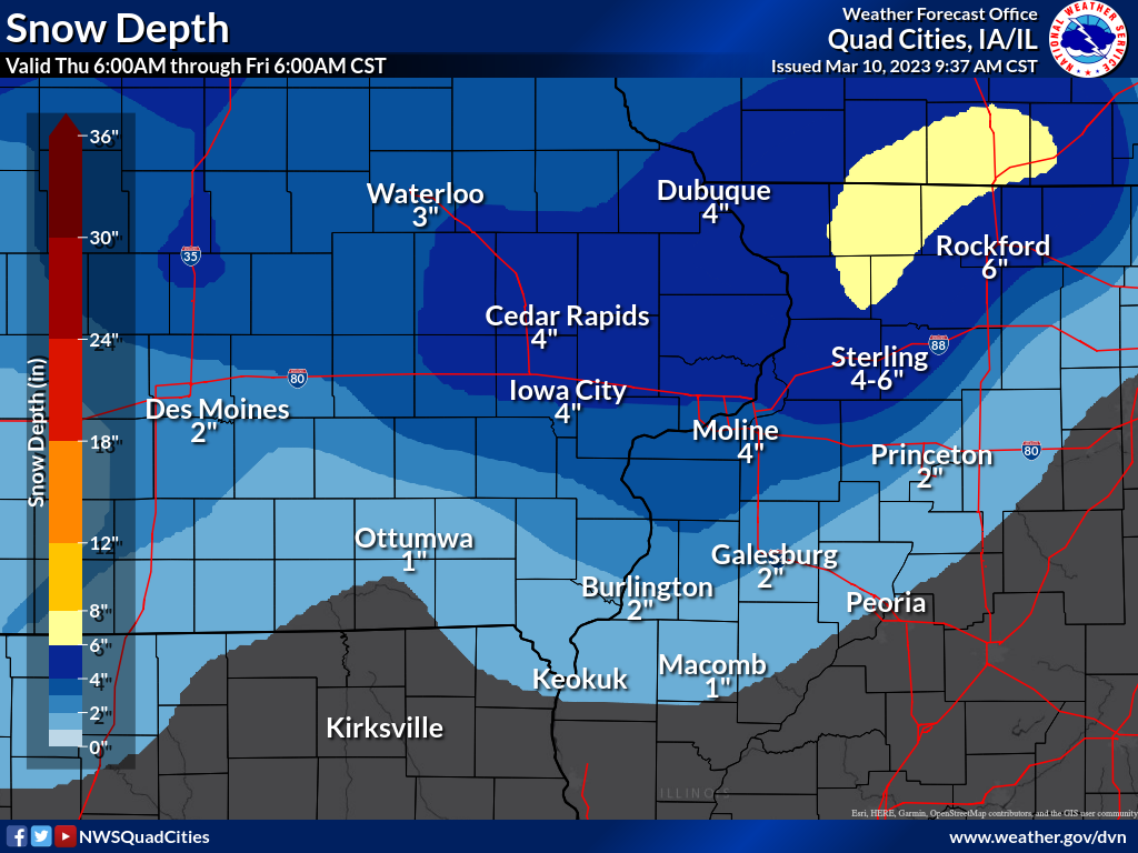
Friday AM Local Snow Depth |
|
 |
 |
📠Storm Reports ðŸ“
Storm Reports Map - Courtesy IEM
.png) |
PUBLIC INFORMATION STATEMENT
NATIONAL WEATHER SERVICE QUAD CITIES IA IL
949 AM CST FRI MAR 10 2023

...MARCH 9-10, 2023 SNOWFALL REPORTS...

LOCATION                     AMOUNT    TIME/DATE       PROVIDER
LOWDEN                       6.6 IN    0700 AM 03/10   CO-OP OBSERVER
2 WNW FREEPORT               6.5 IN    0705 AM 03/10   TRAINED SPOTTER
MILLEDGEVILLE                6.1 IN    0715 AM 03/10   TRAINED SPOTTER
ORANGEVILLE                  6.0 IN    0906 AM 03/10   TRAINED SPOTTER
1 ENE GALENA TERRITORY       6.0 IN    0800 AM 03/10   TRAINED SPOTTER
3 SW WINNESHIEK              5.5 IN    0907 AM 03/10   TRAINED SPOTTER
FREEPORT                     5.5 IN    1015 PM 03/09   TRAINED SPOTTER
1 N INDEPENDENCE             5.4 IN    0648 AM 03/10   TRAINED SPOTTER
ANAMOSA 3 SSW                5.2 IN    0600 AM 03/10   COOP
1 NW DUBUQUE REGIONAL ARPT   5.1 IN    0648 AM 03/10   OFFICIAL NWS OBS
2 SE ASBURY                  5.0 IN    0919 AM 03/10   TRAINED SPOTTER
4 SSE LORAN                  5.0 IN    0800 AM 03/10   TRAINED SPOTTER
MOUNT CARROLL                5.0 IN    0700 AM 03/10   COOP
2 ESE GALENA                 5.0 IN    0656 AM 03/10   TRAINED SPOTTER
HIAWATHA                     5.0 IN    0230 AM 03/10   TRAINED SPOTTER
FREEPORT 2.9 WSW             4.9 IN    0800 AM 03/10   COCORAHS
MOUNT CARROLL                4.8 IN    0925 AM 03/10   TRAINED SPOTTER
STOCKTON 3 NNE               4.8 IN    0735 AM 03/10   COOP
STOCKTON 3.4 NNE             4.8 IN    0730 AM 03/10   COCORAHS
PARK VIEW 0.2 WSW            4.5 IN    0700 AM 03/10   COCORAHS
LISBON 0.1 W                 4.5 IN    0700 AM 03/10   COCORAHS
LISBON                       4.5 IN    0638 AM 03/10   TRAINED SPOTTER
DAVENPORT 6 N                4.4 IN    0600 AM 03/10   COOP
 NULL DAVENPORT AIRPORT      4.4 IN    1200 AM 03/10   OFFICIAL NWS OBS
NORTH LIBERTY 0.7 SSW        4.3 IN    0800 AM 03/10   COCORAHS
1 SSE EDMORE                 4.3 IN    0556 AM 03/10   TRAINED SPOTTER
RICKARDSVILLE                4.1 IN    0646 AM 03/10   TRAINED SPOTTER
ELIZABETH                    4.1 IN    0630 AM 03/10   COOP
1 SW UNIVERSITY HEIGHTS      4.1 IN    0947 PM 03/09   TRAINED SPOTTER
MONTICELLO                   4.0 IN    0720 AM 03/10   COOP
CALAMUS 2.0 NE               4.0 IN    0700 AM 03/10   COCORAHS
2 N MUSCATINE                4.0 IN    0700 AM 03/10   COOP
EAST DUBUQUE 1.7 SE          4.0 IN    0700 AM 03/10   COCORAHS
GENESEO 2.0 NW               4.0 IN    0700 AM 03/10   COCORAHS
NICHOLS 2.5 NNW              4.0 IN    0700 AM 03/10   COCORAHS
MARENGO 2.6 SSW              4.0 IN    0600 AM 03/10   COCORAHS
MOUNT AUBURN 2.2 NNW         4.0 IN    0600 AM 03/10   COCORAHS
2 ENE HAZLETON               4.0 IN    1219 AM 03/10   CO-OP OBSERVER
2 W CEDAR RAPIDS             4.0 IN    1115 PM 03/09   TRAINED SPOTTER
1 NW CENTER GROVE            3.9 IN    0650 AM 03/10   TRAINED SPOTTER
1 WNW COU FALLS              3.9 IN    1004 PM 03/09   PUBLIC
SOLON 0.3 ESE                3.8 IN    0700 AM 03/10   COCORAHS
CLINTON 1.7 NNW              3.7 IN    0600 AM 03/10   COCORAHS
CASCADE                      3.6 IN    0700 AM 03/10   COOP
ROBINS 0.8 SE                3.6 IN    0700 AM 03/10   COCORAHS
CEDAR RAPIDS 2.1 NW          3.6 IN    0700 AM 03/10   COCORAHS
4 NNE STOCKTON               3.6 IN    1000 PM 03/09   TRAINED SPOTTER
STANWOOD                     3.5 IN    0737 AM 03/10   TRAINED SPOTTER
2 W WOODBINE                 3.5 IN    0700 AM 03/10   TRAINED SPOTTER
1 E WILLIAMSBURG             3.5 IN    0700 AM 03/10   COOP
NORTH ENGLISH                3.5 IN    0700 AM 03/10   COOP
PARNELL                      3.5 IN    0510 AM 03/10   PUBLIC
PARNELL 0.1 SSW              3.5 IN    0455 AM 03/10   COCORAHS
BETTENDORF 1.6 W             3.4 IN    0730 AM 03/10   COCORAHS
2 W BETTENDORF               3.4 IN    0500 AM 03/10   NWS EMPLOYEE
2 NNW WARNER                 3.2 IN    0709 AM 03/10   TRAINED SPOTTER
ALEDO                        3.2 IN    0700 AM 03/10   COOP
COAL VALLEY 2.6 E            3.2 IN    0700 AM 03/10   COCORAHS
PRESTON                      3.1 IN    0739 AM 03/10   TRAINED SPOTTER
2 S COGGON                   3.0 IN    0817 AM 03/10   TRAINED SPOTTER
COAL VALLEY 1.9 SE           3.0 IN    0700 AM 03/10   COCORAHS
WASHINGTON 5.8 SW            3.0 IN    0700 AM 03/10   COCORAHS
GENESEO                      3.0 IN    1200 AM 03/10   COOP
MANCHESTER                   2.8 IN    0700 AM 03/10   COOP
2 N NEW WINDSOR              2.7 IN    0657 AM 03/10   TRAINED SPOTTER
DAVENPORT 0.9 WNW            2.5 IN    0530 AM 03/10   COCORAHS
MOLINE 0.7 NNE               2.4 IN    0700 AM 03/10   COCORAHS
RIVERDALE 0.5 N              2.4 IN    0700 AM 03/10   COCORAHS
CAMBRIDGE                    2.2 IN    0800 AM 03/10   TRAINED SPOTTER
CAMANCHE 1.2 W               2.1 IN    0700 AM 03/10   COCORAHS
1 SSW KEWANEE                2.0 IN    0700 AM 03/10   TRAINED SPOTTER
PRINCETON                    2.0 IN    0700 AM 03/10   COOP
PRINCETON 1.1 SE             2.0 IN    0700 AM 03/10   COCORAHS
WALNUT 5.3 ENE               1.8 IN    0700 AM 03/10   COCORAHS
IOWA CITY 2.3 E              1.6 IN    0700 AM 03/10   COCORAHS
FAIRFIELD 5.7 NNE            1.6 IN    0700 AM 03/10   COCORAHS
WASHINGTON 2 SSW             1.5 IN    0700 AM 03/10   COOP
STRONGHURST 0.4 SSW          1.1 IN    0700 AM 03/10   COCORAHS
LA HARPE                     1.0 IN    0800 AM 03/10   COOP
FAIRFIELD                    1.0 IN    0800 AM 03/10   COOP

OBSERVATIONS ARE COLLECTED FROM A VARIETY OF SOURCES WITH VARYING
EQUIPMENT AND EXPOSURES. WE THANK ALL VOLUNTEER WEATHER OBSERVERS
FOR THEIR DEDICATION. NOT ALL DATA LISTED ARE CONSIDERED OFFICIAL.

$$
 |
Media use of NWS Web News Stories is encouraged! Please acknowledge the NWS as the source of any news information accessed from this site. |
|