Tropical system in the Gulf expected to gradually strengthen the next couple of days off the Florida Panhandle and Alabama coasts. Instances of flash flooding will be possible through Thursday along the eastern and central Gulf Coast. Severe thunderstorms will develop and move along a cold front crossing the Upper Midwest, and through the Ohio Valley/Mid-Atlantic on Tuesday. Read More >
Overview
|
|
 |
| Event Summary |
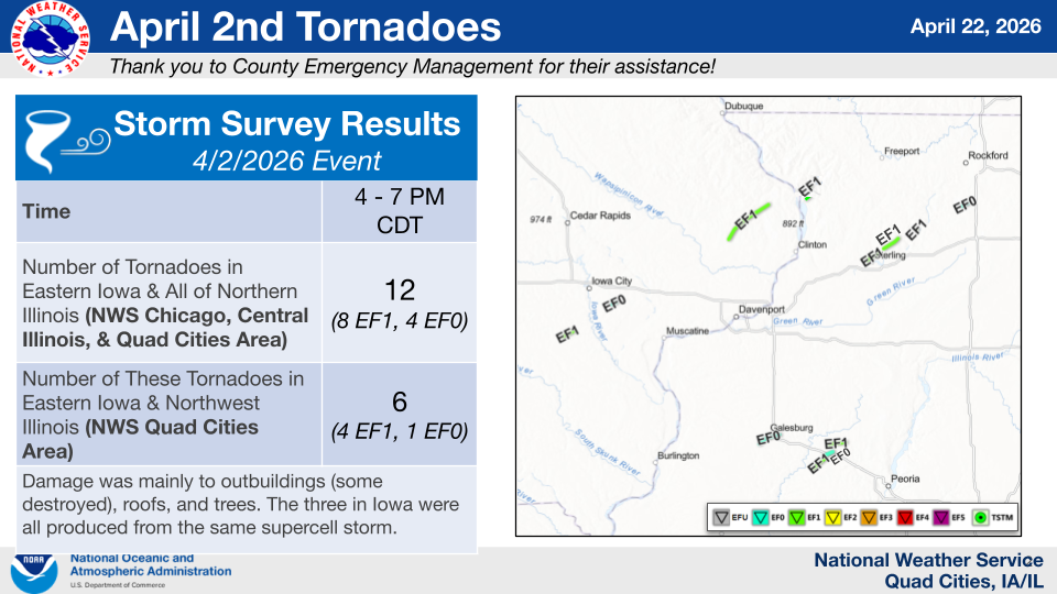
Summary of Documented Tornadoes |
Other NWS Office Event Recaps: Northeast Illinois (NWS Chicago) | Central Illinois (NWS Lincoln)
Tornadoes
Select a tornado from the table to zoom into the track and view more information. The default table view is limited to 8 tracks, but can be scrolled by a mouse wheel or dynamically expanded. Additionally, the table can fill the entire window by clicking the small circular expanding arrow icon at the very top right of the table and returned to its original size by clicking the button again. The side information panel that opens over the map can be closed using the "X" on the upper right corner of the pop-up. Zoom into the map and click damage points to see detailed information and pictures from the surveys.
Public Info Statement on April 2nd Surveys (NWS Quad Cities)
Public Info Statement from NWS Chicago on Eastern Whiteside into Lee County (NWS Chicago)
NOTE: A tornado that crosses NWS Areas, such as the Whiteside to Lee County tornado, will not show up in the dashboard (table) but will on the map.
|
NOTE: times shown below are local to your device's time zone. |

The Enhanced Fujita (EF) Scale classifies tornadoes into the following categories:
| EF0 Weak 65-85 mph |
EF1 Moderate 86-110 mph |
EF2 Significant 111-135 mph |
EF3 Severe 136-165 mph |
EF4 Extreme 166-200 mph |
EF5 Catastrophic 200+ mph |
 |
|||||
| Tornadoes that fail to impact any ratable damage indicators on the EF-Scale are rated EF-Unknown (EF-U) | |||||
 |
 |
 |
| Washington County, IA Tornado | Johnson and Muscatine Counties, IA Tornado | Clinton and Jackson Counties, IA Tornado |
 |
 |
 |
| Carroll County, IL Tornado | Whiteside County, IL Tornado | Whiteside County into Lee County, IL Tornado (thank you to NWS Chicago) |
Storm Reports & Hail Swaths
 |
 |
| Radar Estimated Hail Swaths |
Preliminary Local Storm Report...Summary
National Weather Service Quad Cities IA IL
334 PM CDT Tue Apr 7 2026

..TIME...   ...EVENT...      ...CITY LOCATION...     ...LAT.LON...
..DATE...   ....MAG....      ..COUNTY LOCATION..ST.. ...SOURCE....
            ..REMARKS..

0332 PM     Hail             2 E Martinsburg         41.18N 92.21W
04/02/2026  E3.00 Inch       Keokuk             IA   Public

            Time estimated from radar. Public report
            relayed by broadcast media.

0335 PM     Hail             4 WNW Ollie             41.22N 92.15W
04/02/2026  M1.25 Inch       Keokuk             IA   Public


0356 PM     Tstm Wnd Gst     3 E Keota               41.37N 91.90W
04/02/2026  M50 MPH          Washington         IA   Trained Spotter

            Measured with anemometer.

0359 PM     Tstm Wnd Gst     3 NW Parnell            41.62N 92.05W
04/02/2026  M64 MPH          Iowa               IA   Mesonet


0411 PM     Tornado          2 S Richmond            41.43N 91.70W
04/02/2026                   Washington         IA   NWS Storm Survey

            This tornado snapped/uprooted trees, bent
            power poles, and damaged several
            outbuildings along its path. The roofs on 1
            machine shed and 3 hog confinement buildings
            were also destroyed.

0413 PM     Hail             1 W Kalona              41.49N 91.71W
04/02/2026  M1.75 Inch       Washington         IA   Trained Spotter


0413 PM     Hail             1 NNW Kalona            41.50N 91.71W
04/02/2026  E2.50 Inch       Washington         IA   Emergency Mngr

            Damage to two squad cars on Iowa Highway 1,
            including a cracked windshield on one. Hail
            size estimated by deputies. Time estimated
            using radar.

0418 PM     Funnel Cloud     5 NNE West Chester      41.41N 91.79W
04/02/2026                   Washington         IA   Trained Spotter

            near the ground with debris.

0431 PM     Hail             1 ESE Iowa City Municip 41.63N 91.53W
04/02/2026  E1.75 Inch       Johnson            IA   Public

            Media.

0436 PM     Tornado          3 SW Downey             41.58N 91.39W
04/02/2026                   Johnson            IA   NWS Storm Survey

            An EF0 tornado lofted a corn crib, snapped
            trees, bent an auger, and partially
            destroyed a roof on a farm outbuilding.

0451 PM     Hail             Quad City Airport       41.40N 90.55W
04/02/2026  M0.88 Inch       Rock Island        IL   Trained Spotter


0456 PM     Tstm Wnd Gst     3 SW Tipton             41.75N 91.17W
04/02/2026  M58 MPH          Cedar              IA   Mesonet


0457 PM     Hail             Tipton                  41.77N 91.13W
04/02/2026  M1.75 Inch       Cedar              IA   Emergency Mngr

            EM reported golf ball size hail and
            extensive hail related damage, including to
            a greenhouse and to roofs and siding in
            town.

0500 PM     Hail             4 SSE Clarence          41.83N 91.04W
04/02/2026  E1.00 Inch       Cedar              IA   Trained Spotter

            Report from Trained Spotter: Quarter (1
            in.).

0505 PM     Hail             1 E Coal Valley         41.45N 90.43W
04/02/2026  E1.00 Inch       Henry              IL   Trained Spotter


0509 PM     Hail             Silvis                  41.51N 90.41W
04/02/2026  E1.00 Inch       Rock Island        IL   Public

            Time estimated from radar.

0509 PM     Hail             1 SW Coal Valley        41.44N 90.46W
04/02/2026  M1.00 Inch       Rock Island        IL   Trained Spotter


0509 PM     Hail             1 S Silvis              41.49N 90.41W
04/02/2026  E1.00 Inch       Rock Island        IL   Public

            Report from mPING: Quarter (1.00 in.).

0510 PM     Hail             1 S Moline              41.48N 90.49W
04/02/2026  E1.00 Inch       Rock Island        IL   Public

            Report from mPING: Quarter (1.00 in.).

0512 PM     Tstm Wnd Gst     Lowden                  41.86N 90.92W
04/02/2026  M60 MPH          Cedar              IA   CO-OP Observer


0512 PM     Hail             Lowden                  41.86N 90.92W
04/02/2026  M1.75 Inch       Cedar              IA   CO-OP Observer


0518 PM     Tstm Wnd Gst     3 ENE Oxford Junction   42.00N 90.89W
04/02/2026  M61 MPH          Clinton            IA   Mesonet


0518 PM     Tstm Wnd Gst     Wheatland               41.83N 90.84W
04/02/2026  E60 MPH          Clinton            IA   Broadcast Media

            Time estimated using radar.

0520 PM     Hail             3 NNE Osborn            41.56N 90.24W
04/02/2026  E1.00 Inch       Rock Island        IL   Trained Spotter


0525 PM     Tornado          2 WSW Welton            41.90N 90.63W
04/02/2026                   Clinton            IA   NWS Storm Survey

            An NWS Storm Damage Survey Team confirmed an
            EF1 tornado with peak winds of 105 mph and
            maximum estimated width of 250 yards. Damage
            included over ten snapped power poles, over
            ten outbuildings and sheds destroyed,
            numerous homes with shingle damage, and many
            trees with large sections snapped.

0526 PM     Tstm Wnd Gst     1 SE Clinton Municipali 41.82N 90.32W
04/02/2026  M55 MPH          Clinton            IA   AWOS

            AWOS station KCWI Clinton Arpt.

0537 PM     Hail             3 N Thomson             42.00N 90.11W
04/02/2026  M3.00 Inch       Carroll            IL   Trained Spotter

            Pictures of hail ranging in size from 3.00
            to 3.25 inches. The time of the event was
            estimated using radar.

0538 PM     Hail             2 N Thomson             41.99N 90.10W
04/02/2026  E1.75 Inch       Carroll            IL   Public


0548 PM     Hail             Mount Carroll           42.10N 89.98W
04/02/2026  E1.50 Inch       Carroll            IL   Public

            Social media picture of quarter to ping pong
            size hail. Relayed by media.

0554 PM     Tstm Wnd Gst     Prophetstown            41.66N 89.94W
04/02/2026  M67 MPH          Whiteside          IL   Mesonet


0556 PM     Tstm Wnd Gst     Davenport Municipality  41.62N 90.58W
04/02/2026  M56 MPH          Scott              IA   ASOS

            ASOS station KDVN Davenport Arpt.

0557 PM     Tstm Wnd Dmg     1 SE Savanna            42.08N 90.12W
04/02/2026                   Carroll            IL   Public

            Large tree down, other trees stripped of
            bark. Time estimated from radar.

0557 PM     Tstm Wnd Gst     Park View               41.69N 90.54W
04/02/2026  E60 MPH          Scott              IA   NWS Employee


0600 PM     Tornado          2 NE Savanna            42.11N 90.11W
04/02/2026                   Carroll            IL   NWS Storm Survey

            A brief EF1 tornado developed northeast of
            Savanna with maximum winds near 90 mph. The
            tornado caused tree damage, with tree fall
            indicative of a convergent path, and also
            tossed and damaged a small shed.

0602 PM     Tornado          2 WSW Sterling          41.80N 89.73W
04/02/2026                   Whiteside          IL   NWS Storm Survey

            An EF1 tornado passed through northern
            portions of Sterling, with estimated maximum
            wind speeds around 90 mph. Along the path,
            damage was done to trees (including snapped)
            and two garages in the path saw complete
            loss of their roofs. Minor damage was noted
            to two church roofs. There was also a 3000
            lb rooftop HVAC unit rolled over, consistent
            with maximum winds of at least 90 mph.

0613 PM     Tstm Wnd Gst     3 N Stockton            42.40N 89.99W
04/02/2026  M50 MPH          Jo Daviess         IL   Public


0619 PM     Tstm Wnd Gst     1 E Whiteside County Ai 41.75N 89.67W
04/02/2026  M56 MPH          Whiteside          IL   AWOS

            AWOS station KSQI Sterling/Rock Falls Arpt.

0620 PM     Hail             2 SW Whiteside County A 41.73N 89.72W
04/02/2026  E1.50 Inch       Whiteside          IL   Trained Spotter


0703 PM     Tstm Wnd Gst     Hennepin                41.26N 89.33W
04/02/2026  M61 MPH          Putnam             IL   Public


0703 PM     Tstm Wnd Dmg     1 W Hennepin            41.25N 89.35W
04/02/2026                   Putnam             IL   Emergency Mngr

            Home with garage door blown in and multiple
            3-inch tree limbs snapped. Time estimated
            from radar.

0703 PM     Tstm Wnd Dmg     1 W Hennepin            41.26N 89.34W
04/02/2026                   Putnam             IL   Emergency Mngr

            Corrects previous tstm wnd dmg report from 1
            W Hennepin. Multiple trees, some 6- to
            8-inches thick, snapped at the base or
            uprooted. Time estimated from radar.

0703 PM     Tstm Wnd Dmg     Depue                   41.33N 89.30W
04/02/2026                   Bureau             IL   Emergency Mngr

            Tree uprooted and fell on house. Did not
            breach the structure. Time estimated from
            radar.

0709 PM     Tstm Wnd Dmg     Mark                    41.27N 89.24W
04/02/2026                   Putnam             IL   Emergency Mngr

            Putnam county EMA reports a power line down
            in Hennepin. Time estimated by radar.
|
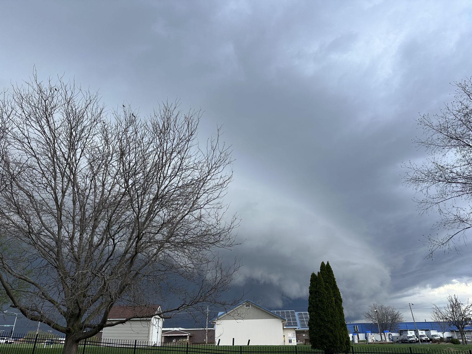
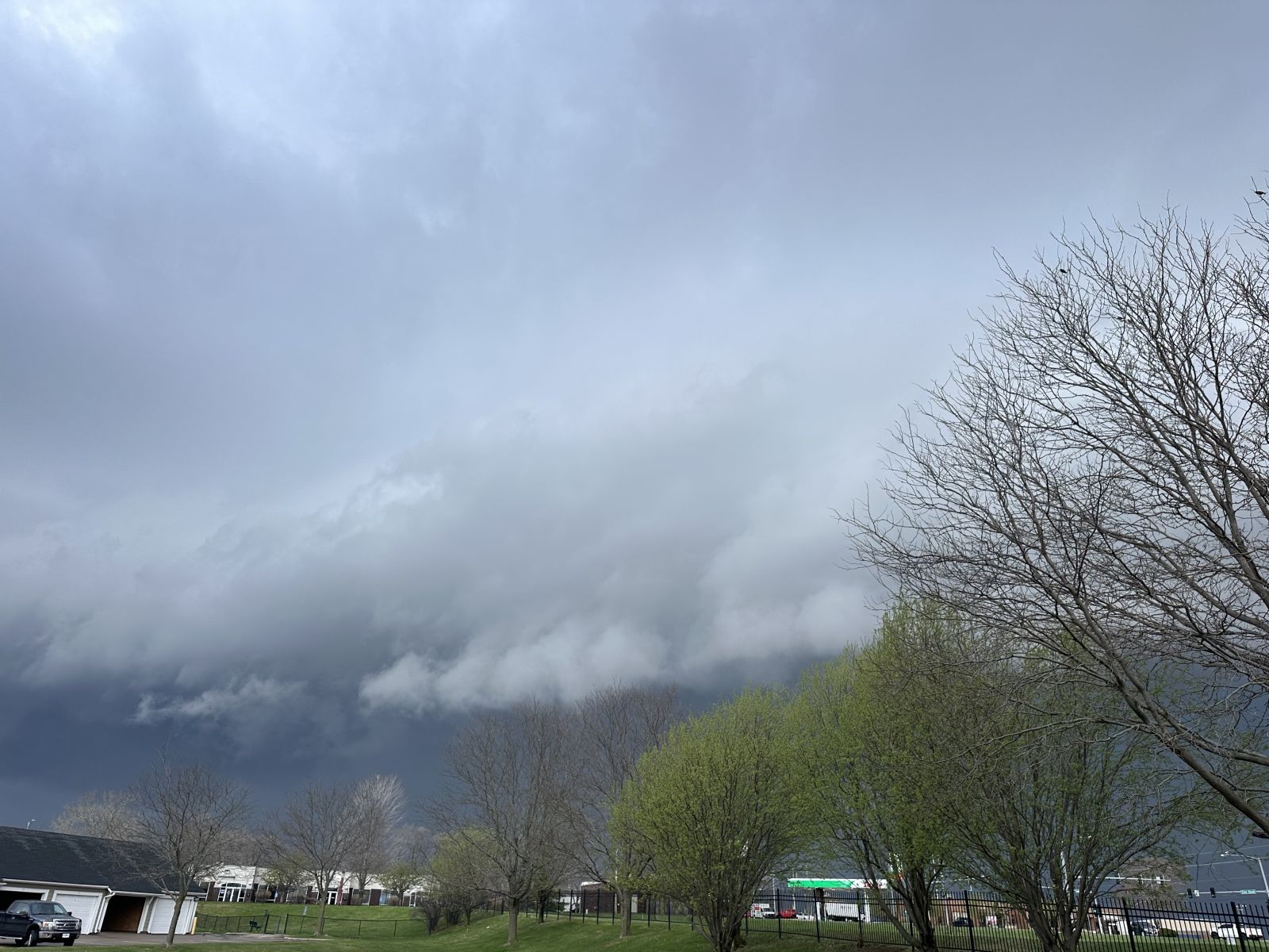
Photos
|
|
 |
 |
| Hail from Thomson, IL in Carroll County. Courtesy of Shawn Anderson. | Hail damage to siding near Ollie, IA. Often hail damage to siding usually means it was accompanied by near-severe to severe wind gusts. Courtesy of Justin Schultz. | Hail at or slightly larger than golf ball size hail from Tipton, IA where extensive hail damage occurred. Courtesy of Cedar County EMA. |
 |
 |
|
| Davenport IA - TJ Gunkel | Davenport IA - TJ Gunkel | More on Shelf Clouds |
 |
 |
 |
| SW Petersville, IA - NWS Storm Survey | NE Petersville, IA - NWS Storm Survey | Preston, IA - NWS Storm Survey |
 |
 |
 |
| 2SW Downey, IA - Muscatine County EM | 2SW Downey, IA - Muscatine County EM | Kalona Tornado looking northeast - Adam Lucio |
Rain Reports
...COCORAHS PRECIPITATION REPORTS...

THESE REPORTS ARE CONSIDERED SUPPLEMENTAL AND UNOFFICIAL
VALUES ARE FOR THE PREVIOUS 24 HOURS ENDING AROUND 7 AM LOCAL TIME

FOR MORE INFORMATION ON THE COCORAHS PROGRAM, PLEASE VISIT
WWW.COCORAHS.ORG

.B DVN 0403 C DH07/PP/SF/SD/SW
:
:
:COCORAHS PRECIPITATION REPORTS IN ILLINOIS
:
:                                           SNOW   SNOW    WATER
:                                    PCPN   FALL   DEPTH   EQUIV
:
IL-CR-20   : LANARK 5.3 N          : 1.44 /   MM /    MM /    MM
IL-PM-06   : MCNABB 1.4 NW         : 1.39 /   MM /    MM /    MM
IL-WD-25   : PROPHETSTOWN 0.6 ESE  : 1.36 /   MM /    MM /    MM
IL-WD-22   : ROCK FALLS 3.1 S      : 1.11 /   MM /    MM /    MM
IL-BU-11   : WALNUT 5.3 ENE        : 1.05 /   MM /    MM /    MM
IL-WD-24   : STERLING 5.9 NNE      : 1.02 /   MM /    MM /    MM
IL-SP-28   : FREEPORT 4.3 W        : 1.01 /   MM /    MM /    MM
IL-JD-11   : EAST DUBUQUE 1.7 SE   : 0.94 /   MM /    MM /    MM
IL-SP-26   : FREEPORT 2.9 WSW      : 0.93 /   MM /    MM /    MM
IL-JD-16   : GALENA 0.8 WSW        : 0.91 /   MM /    MM /    MM
IL-CR-22   : LANARK 4.2 NNW        : 0.90 /   MM /    MM /    MM
IL-HY-30   : COLONA 0.5 ESE        : 0.90 /   MM /    MM /    MM
IL-HD-01   : STRONGHURST 0.4 SSW   : 0.89 /   MM /    MM /    MM
IL-HY-27   : COLONA 1.3 WNW        : 0.83 /   MM /    MM /    MM
IL-WD-05   : MORRISON 3.2 E        : 0.83 /   MM /    MM /    MM
IL-JD-15   : STOCKTON 5.9 WNW      : 0.78 /   MM /    MM /    MM
IL-HY-04   : ATKINSON 2.6 NNE      : 0.65 /   MM /    MM /    MM
IL-JD-06   : HANOVER 0.2 NW        : 0.65 /   MM /    MM /    MM
IL-HN-01   : DALLAS CITY 3.0 SSE   : 0.64 /  0.0 /   0.0 /  0.00
IL-HY-08   : GENESEO 2.0 NW        : 0.63 /   MM /    MM /    MM
IL-MCD-07  : COLCHESTER 3.5 NE     : 0.63 /   MM /    MM /    MM
IL-RI-13   : MOLINE 0.7 NNE        : 0.63 /   MM /    MM /    MM
IL-CR-12   : MOUNT CARROLL 6.8 NNW : 0.58 /  0.0 /   0.0 /    MM
IL-SP-31   : LENA 0.3 SSE          : 0.52 /   MM /    MM /    MM
IL-JD-13   : STOCKTON 4.6 NW       : 0.50 /   MM /    MM /    MM
IL-JD-17   : STOCKTON 4.5 N        : 0.48 /   MM /    MM /    MM
IL-SP-35   : RIDOTT 3.2 WNW        : 0.47 /   MM /    MM /    MM
IL-WR-07   : MONMOUTH 0.4 SE       : 0.46 /   MM /    MM /    MM
IL-JD-08   : STOCKTON 3.4 NNE      : 0.44 /  0.0 /   0.0 /    MM
IL-CR-25   : LANARK 0.3 SSW        : 0.41 /   MM /    MM /    MM
IL-HN-02   : WARSAW 5.8 SE         : 0.36 /   MM /    MM /    MM
IL-HY-06   : NEW WINDSOR 2.0 N     : 0.31 /   MM /    MM /    MM
IL-MR-10   : VIOLA 0.4 E           : 0.28 /   MM /    MM /    MM
:
:
:COCORAHS PRECIPITATION REPORTS IN EASTERN IOWA
:
:                                           SNOW   SNOW    WATER
:                                    PCPN   FALL   DEPTH   EQUIV
:
IA-WS-07   : WELLMAN 4.0 E         : 1.57 /   MM /    MM /    MM
IA-LN-71   : COGGON 0.3 ENE        : 1.40 /   MM /    MM /    MM
IA-JH-54   : IOWA CITY 2.3 E       : 1.37 /   MM /    MM /    MM
IA-IA-13   : PARNELL 0.1 SSW       : 1.32 /   MM /    MM /    MM
IA-DW-06   : HOPKINTON 5.4 WSW     : 1.31 /   MM /    MM /    MM
IA-JH-63   : IOWA CITY 3.5 E       : 1.31 /   MM /    MM /    MM
IA-MC-10   : MUSCATINE 1.4 N       : 1.30 /   MM /    MM /    MM
IA-WS-02   : AINSWORTH 7.4 N       : 1.29 /   MM /    MM /    MM
IA-CD-10   : CLARENCE 3.9 S        : 1.27 /   MM /    MM /    MM
IA-JH-50   : IOWA CITY 3.7 E       : 1.27 /   MM /    MM /    MM
IA-LN-07   : CENTRAL CITY 6.7 W    : 1.20 /   MM /    MM /    MM
IA-LN-66   : CENTER POINT 0.5 N    : 1.13 /   MM /    MM /    MM
IA-BT-16   : SHELLSBURG 2.9 S      : 1.12 /   MM /    MM /    MM
IA-KK-07   : HAYESVILLE 0.2 SW     : 1.09 /   MM /    MM /    MM
IA-JH-39   : IOWA CITY 1.0 NE      : 1.07 /   MM /    MM /    MM
IA-JH-61   : IOWA CITY 2.0 WSW     : 1.07 /   MM /    MM /    MM
IA-JN-10   : CENTER JUNCTION 2.6 W : 1.05 /   MM /    MM /    MM
IA-CD-08   : TIPTON 0.3 ESE        : 1.03 /   MM /    MM /    MM
IA-JH-27   : NORTH LIBERTY 0.7 SSW : 1.03 /   MM /    MM /    MM
IA-ST-03   : PARK VIEW 0.2 WSW     : 1.00 /   MM /    MM /    MM
IA-ST-30   : ELDRIDGE 0.7 SSW      : 1.00 /    T /    MM /    MM
IA-JH-57   : IOWA CITY 1.2 WSW     : 0.97 /   MM /    MM /    MM
IA-LN-27   : MARION 1.7 NNW        : 0.97 /   MM /    MM /    MM
IA-LN-70   : MARION 3.3 N          : 0.96 /   MM /    MM /    MM
IA-BT-12   : FAIRFAX 4.0 NW        : 0.95 /  0.0 /   0.0 /  0.00
IA-JH-01   : SOLON 0.3 ESE         : 0.95 /   MM /    MM /    MM
IA-JH-38   : WEST BRANCH 2.3 SSW   : 0.95 /   MM /    MM /    MM
IA-JH-08   : NORTH LIBERTY 1.0 ENE : 0.94 /   MM /    MM /    MM
IA-JH-46   : IOWA CITY 2.8 WSW     : 0.94 /   MM /    MM /    MM
IA-JH-58   : IOWA CITY 1.4 NNE     : 0.94 /   MM /    MM /    MM
IA-JH-37   : SOLON 0.4 WNW         : 0.93 /   MM /    MM /    MM
IA-JH-48   : CORALVILLE 1.7 SSE    : 0.92 /   MM /    MM /    MM
IA-DW-10   : DUNDEE 1.4 NNE        : 0.91 /   MM /    MM /    MM
IA-LN-53   : ROBINS 0.8 SE         : 0.90 /  0.0 /   0.0 /  0.00
IA-BC-08   : INDEPENDENCE 0.9 WNW  : 0.89 /  0.0 /    MM /    MM
IA-BT-11   : MOUNT AUBURN 2.2 NNW  : 0.89 /   MM /    MM /    MM
IA-LN-59   : MARION 0.4 NNW        : 0.89 /   MM /    MM /    MM
IA-LN-61   : ELY 2.0 N             : 0.88 /   MM /    MM /    MM
IA-ST-21   : ELDRIDGE 0.6 S        : 0.87 /   MM /    MM /    MM
IA-DB-31   : BELLEVUE 12.2 NW      : 0.84 /   MM /    MM /    MM
IA-BT-24   : MOUNT AUBURN 0.1 SSW  : 0.83 /  0.0 /   0.0 /  0.00
IA-LN-31   : CEDAR RAPIDS 2.7 NE   : 0.83 /   MM /    MM /    MM
IA-LN-63   : MARION 0.9 NE         : 0.76 /   MM /    MM /    MM
IA-JF-12   : FAIRFIELD 5.7 NNE     : 0.74 /   MM /    MM /    MM
IA-BC-09   : WINTHROP 5.6 NNE      : 0.73 /   MM /    MM /    MM
IA-JH-20   : CORALVILLE 1.4 S      : 0.71 /   MM /    MM /    MM
IA-JF-14   : FAIRFIELD 0.7 SE      : 0.69 /   MM /    MM /    MM
IA-JN-16   : ANAMOSA 0.6 ESE       : 0.69 /   MM /    MM /    MM
IA-CN-02   : CALAMUS 2.0 NE        : 0.68 /   MM /    MM /    MM
IA-WS-12   : WASHINGTON 6.5 W      : 0.68 /   MM /    MM /    MM
IA-IA-02   : MARENGO 2.6 SSW       : 0.67 /   MM /    MM /    MM
IA-ST-65   : DAVENPORT 4.3 NE      : 0.65 /  0.0 /   0.0 /    MM
IA-ST-37   : DAVENPORT 0.9 WNW     : 0.60 /   MM /    MM /    MM
IA-LE-16   : KEOKUK 3.4 NW         : 0.58 /   MM /    MM /    MM
IA-CN-22   : CLINTON 1.7 NNW       : 0.56 /  0.0 /   0.0 /  0.00
IA-CN-05   : CAMANCHE 1.2 W        : 0.45 /   MM /    MM /    MM
IA-CN-25   : CLINTON 1.3 NNE       : 0.40 /   MM /    MM /    MM
IA-LE-21   : FORT MADISON 7.7 N    : 0.38 /   MM /    MM /    MM
IA-CN-20   : DE WITT 5.4 ENE       : 0.37 /   MM /    MM /    MM
IA-MC-23   : MUSCATINE 1.7 N       : 0.35 /   MM /    MM /    MM
IA-CN-17   : CHARLOTTE 1.9 WNW     : 0.34 /   MM /    MM /    MM
IA-LS-05   : WAPELLO 5.4 SE        : 0.27 /   MM /    MM /    MM
IA-DM-18   : DANVILLE 2.9 W        : 0.23 /   MM /    MM /    MM
IA-DM-07   : BURLINGTON 6.5 SSW    : 0.17 /   MM /    MM /    MM
IA-LN-49   : CEDAR RAPIDS 2.1 NW   : 0.13 /   MM /    MM /    MM
IA-LS-02   : MORNING SUN 1.7 E     : 0.13 /   MM /    MM /    MM
IA-DM-15   : YARMOUTH 1.9 SW       : 0.12 /   MM /    MM /    MM
IA-HY-05   : SALEM 3.1 ESE         : 0.12 /   MM /    MM /    MM
IA-VB-03   : FARMINGTON 3.5 W      : 0.07 /  0.0 /   0.0 /  0.00
IA-VB-08   : FARMINGTON 2.4 W      : 0.06 /  0.0 /   0.0 /  0.00
IA-VB-07   : FARMINGTON 0.3 NW     : 0.05 /  0.0 /   0.0 /  0.00
IA-VB-09   : FARMINGTON 0.4 NNW    : 0.04 /  0.0 /   0.0 /  0.00
:
:
:COCORAHS PRECIPITATION REPORTS IN NORTHEAST MISSOURI
:
:                                           SNOW   SNOW    WATER
:                                    PCPN   FALL   DEPTH   EQUIV
:
MO-CK-07   : KAHOKA 1.3 ESE        : 0.28 /   MM /    MM /    MM
MO-FSA-199 : MEMPHIS 0.1 S         : 0.15 /   MM /    MM /    MM
MO-CK-04   : KAHOKA 5.2 ESE        : 0.08 /   MM /    MM /    MM
.END
Environment
Synoptic Summary
 |
 |
 |
 |
| 21z - 500 mb Chart | 21z - 700 mb Chart | 21z - 850 mb Chart | 21z - Surface Chart |
Mesoscale Summary
 |
 |
 |
 |
|
21z - MLCAPE Favorable Instability for Convection |
21z - 0-6 km Shear Favorable for Storm Organization |
21z - 0-3 km Shear/CAPE Favorable for Mesovortex Development |
21z - 0-1 km Shear Favorable for Tornadogenesis |
 |
 |
 |
|
21z - LLVL Lapse Rates Favorable for Convection |
21z - Mid-Level Lapse Rates Favorable for Large Hail |
21z - Precipitable Water Favorable for Heavier Rainfall |
Near-Storm Environment Summary
 |
 |
 |
|
4/2 - 18z DVN Sounding |
4/2 - Three hour trend through 2145z of the KDVN Doppler Radar VAD Wind Profile. This depicts large shear and helicity both ideal for supercellular storms. |
4/3 - 00z DVN Sounding |
SPC Outlooks
 |
 |
 |
 |
|
Convective Outlook |
Tornado Threat |
Hail Threat |
Wind Threat |
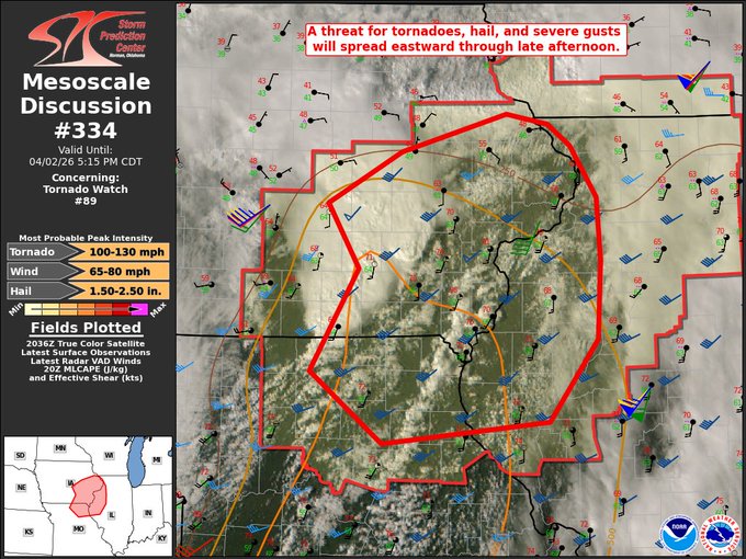
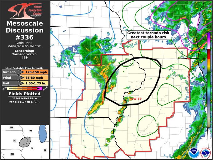
Severe/Tornado Watches & MCDs
 |
 |
 |
 |
|
Tornado Watch 89 |
MCD 334
|
MCD 336 |
 |
Media use of NWS Web News Stories is encouraged! Please acknowledge the NWS as the source of any news information accessed from this site. |
|