Overview
|
Severe thunderstorms developed along a cold front that dropped south across southeastern Iowa and northwest Illinois during the afternoon hours of Wednesday, April 8, 2020. Very large hail was reported with some of the severe storms. The hardest hit areas were parts of southeast Iowa and west central Illinois where hail stones of golf ball to soft ball sized were reported. Other areas that got storms saw copious amounts of small hail which covered the ground. |
 |
Hail Photos:
 |
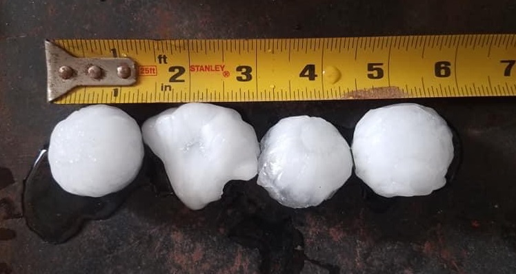 |
| Denmark, IA Courtesy: EMA |
Denmark, IA Courtesy: EMA |
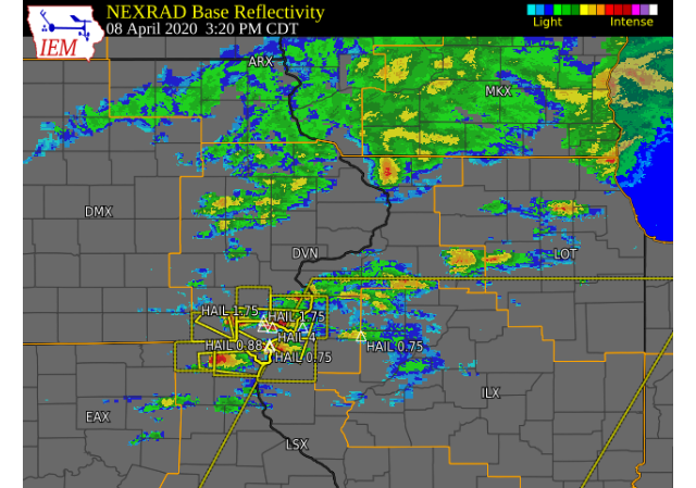
Radar
| Interactive Radar Loop |
 |
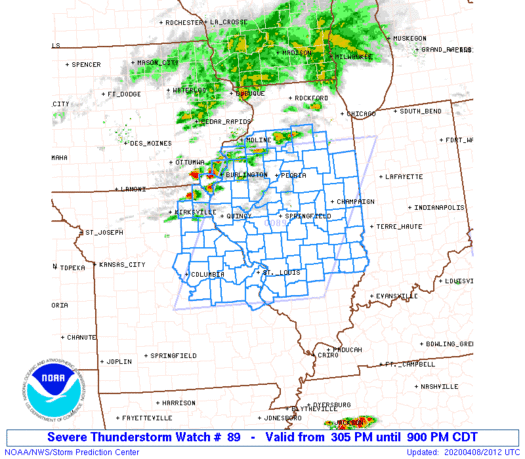
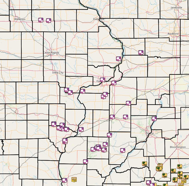
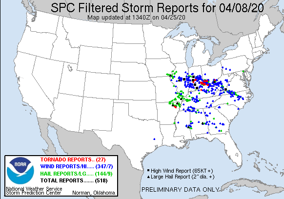
Storm Reports
| Interactive Storm Report Map | SPC Storm Reports |
 |
 |
|
..TIME... ...EVENT... ...CITY LOCATION... ...LAT.LON... 0454 PM HAIL GALVA 41.17N 90.04W EMERGENCY MANAGEMENT AND TRAINED SPOTTERS 0450 PM HAIL COLONA 41.49N 90.35W
0449 PM HAIL MILLEDGEVILLE 41.97N 89.78W
0436 PM HAIL 1 WSW SHERRARD 41.31N 90.53W
0435 PM HAIL 2 NNW CLINTON 41.87N 90.25W LASTED FOR TEN MINUTES FROM 435 TO 445 PM. 0434 PM HAIL 2 SSE DAVENPORT 41.54N 90.59W
0432 PM HAIL 1 ENE BODEN 41.27N 90.57W VIA SOCIAL MEDIA. 0425 PM HAIL AUGUSTA 40.23N 90.95W DIME TO QUARTER HAIL. 0415 PM TSTM WND GST 3 W ADAIR 40.42N 90.56W
0415 PM HAIL 3 W ADAIR 40.42N 90.56W
0415 PM HAIL 5 NNW ELIZA 41.36N 91.01W PEA TO MARBLE. TIME ESTIMATED. 0412 PM HAIL 2 ENE BARDOLPH 40.51N 90.53W MULTIPLE REPORTS OF 1 INCH HAIL. 0411 PM HAIL GOOD HOPE 40.56N 90.68W REPORT FROM MPING: DIME (0.75 IN.). 0410 PM HAIL 2 SSE MACOMB 40.44N 90.67W 1.5 TO 1.75 INCH HAIL. 0409 PM HAIL COLCHESTER 40.43N 90.79W
0405 PM HAIL 2 SW MACOMB 40.45N 90.71W NICKEL HAIL COVERING GROUND. 0400 PM HAIL 4 SE BLANDINSVILLE 40.51N 90.82W LASTED APPROX. 10 MIN. COVERED THE GROUND. 0359 PM HAIL 2 WNW LETTS 41.34N 91.27W VIA SOCIAL MEDIA. 0358 PM HAIL 3 SW BLANDINSVILLE 40.52N 90.89W REPORT FROM MPING: HALF-INCH (0.50 IN.). 0357 PM HAIL CONESVILLE 41.38N 91.35W VIA SOCIAL MEDIA. 0355 PM HAIL MACOMB 40.47N 90.68W VIA SOCIAL MEDIA. 0344 PM HAIL 2 SE CARMAN 40.71N 91.05W
0338 PM HAIL SAINT PAUL 40.77N 91.51W DIME TO NICKEL SIZE HAIL. 0331 PM HAIL 1 ESE SHOKOKON 40.75N 91.04W DIME TO QUARTER SIZED HAIL OCCURRING NOW. 0328 PM HAIL 2 NNE NAUVOO 40.57N 91.38W NICKEL HAIL FOR 2 MINUTES BEGAN AROUND 328 0325 PM HAIL NAUVOO 40.55N 91.38W VIA SOCIAL MEDIAL. 0324 PM HAIL 1 E NAUVOO 40.55N 91.38W
0322 PM HAIL 1 W DENMARK 40.75N 91.35W FIRE DEPARTMENT REPORTS SOFT BALL HAIL WEST 0315 PM HAIL 3 N WEST POINT 40.76N 91.45W
0307 PM HAIL LOWELL 40.82N 91.44W DIME TO THROUGH GOLF BALL SIZE HAIL. 0300 PM HAIL 1 S SALEM 40.83N 91.62W
0257 PM HAIL 1 S SALEM 40.84N 91.62W 911 CENTER RELAYED A REPORT FROM LAW 0214 PM HAIL WINTHROP 42.47N 91.73W
0202 PM HAIL 1 N INDEPENDENCE 42.48N 91.89W MORE HAIL FALLING THEN RAIN.
$$ |
|
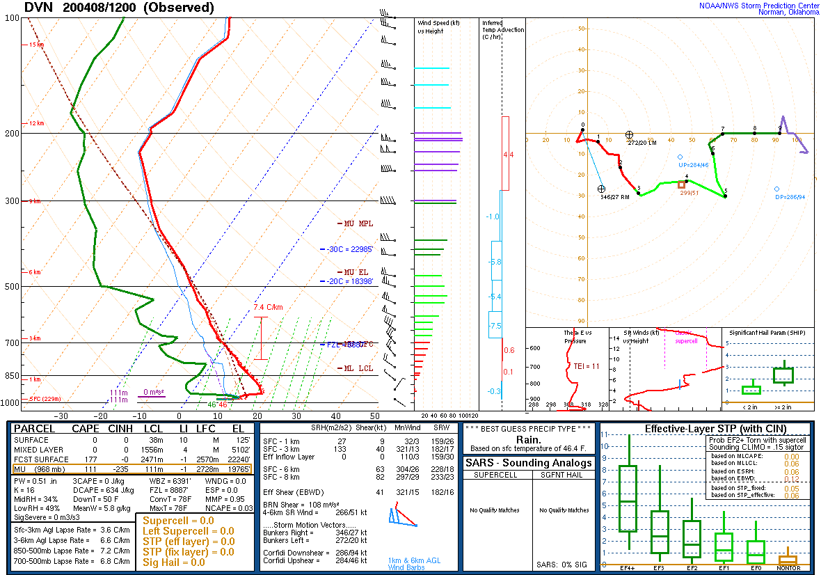
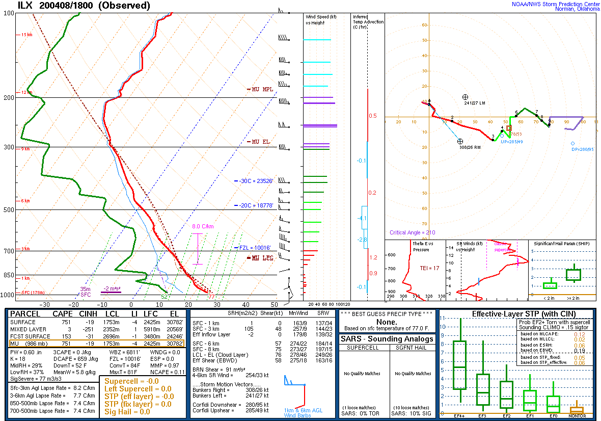
Environment
SPC Event Summary - April 8th, 2020
 |
 |
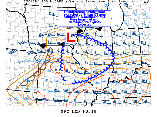 |
| Figure 1: DVN 12z 04/08 Sounding | Figure 2: ILX 18z 04/08 Sounding | Figure 3: SPC MCD #310 |
   Mesoscale Discussion 0310
   NWS Storm Prediction Center Norman OK
   0146 PM CDT Wed Apr 08 2020

   Areas affected...souteast IA...northeast MO...and much of western
   and central IL

   Concerning...Severe potential...Watch likely

   Valid 081846Z - 082045Z

   Probability of Watch Issuance...95 percent

   SUMMARY...Thunderstorm development is expected in the next couple of
   hours near southeast IA/northeast MO/west-central IL. Very large
   hail and damaging winds will be the main threat associated with
   these storms.

   DISCUSSION...Strong heating across southeast IA into MO/IL ahead of
   a surface low and cold front has resulted in weak to moderate
   destabilization this afternoon. Strong boundary layer mixing has
   been noted across IL, where morning dewpoints had been in the mid
   50s F, generally are now in the mid 40s to low 50s F. Further south
   across MO toward southern IL, dewpoints from the low 60s to upper
   50s F were being maintained. Aloft, a plume of very steep midlevel
   lapse rates has continued to spread eastward across the mid-MS
   Valley, with 18z regional RAOBs showing 8-9 C/km lapse rates in
   place. Cumulus development near a quasi-stationary boundary from
   southeast IA into IL has been increasing, while additional deepening
   of midlevel CU near the MO/IA border continues. Stronger height
   falls have been noted recently across SD/NE into southern MN and
   western IA as a lead shortwave impulse begins to eject across the
   area ahead of the main upper trough. This is expected to provide
   adequate forcing for thunderstorm development in the next couple of
   hours.

   Initial development is expected to be semi-discrete, higher-based
   supercells. Forecast hodographs continue to indicate long, straight
   hodographs with speed shear increasing with height. In conjunction
   with very steep lapse rates, large hail (some greater than 2 inches
   in diameter) is expected. Low level lapse rates also are steep
   across the region due to ample heating and mixing. This should act
   to enhance downdrafts, and damaging wind gusts also are expected. As
   frontal forcing increases later this evening, and through storm
   outflow interactions, upscale growth into one or more bowing
   segments is expected across parts of southeast MO into central IL,
   further enhancing the damaging wind threat. Given generally dry low
   levels resulting in higher-based storms, at least initially, the
   tornado threat is expected to be rather marginal.

   ..Leitman/Guyer.. 04/08/2020

   ...Please see www.spc.noaa.gov for graphic product...

   ATTN...WFO...LOT...ILX...LSX...DVN...SGF...DMX...EAX...

   LAT...LON   41029220 41159207 41289159 41359108 41259048 41128995
               40938931 40628849 40138781 39788757 39568758 39328769
               38838828 38358943 38019044 37879151 37949201 38459236
               39509241 40759227 41029220
|
||
 |
Media use of NWS Web News Stories is encouraged! Please acknowledge the NWS as the source of any news information accessed from this site. |
|

