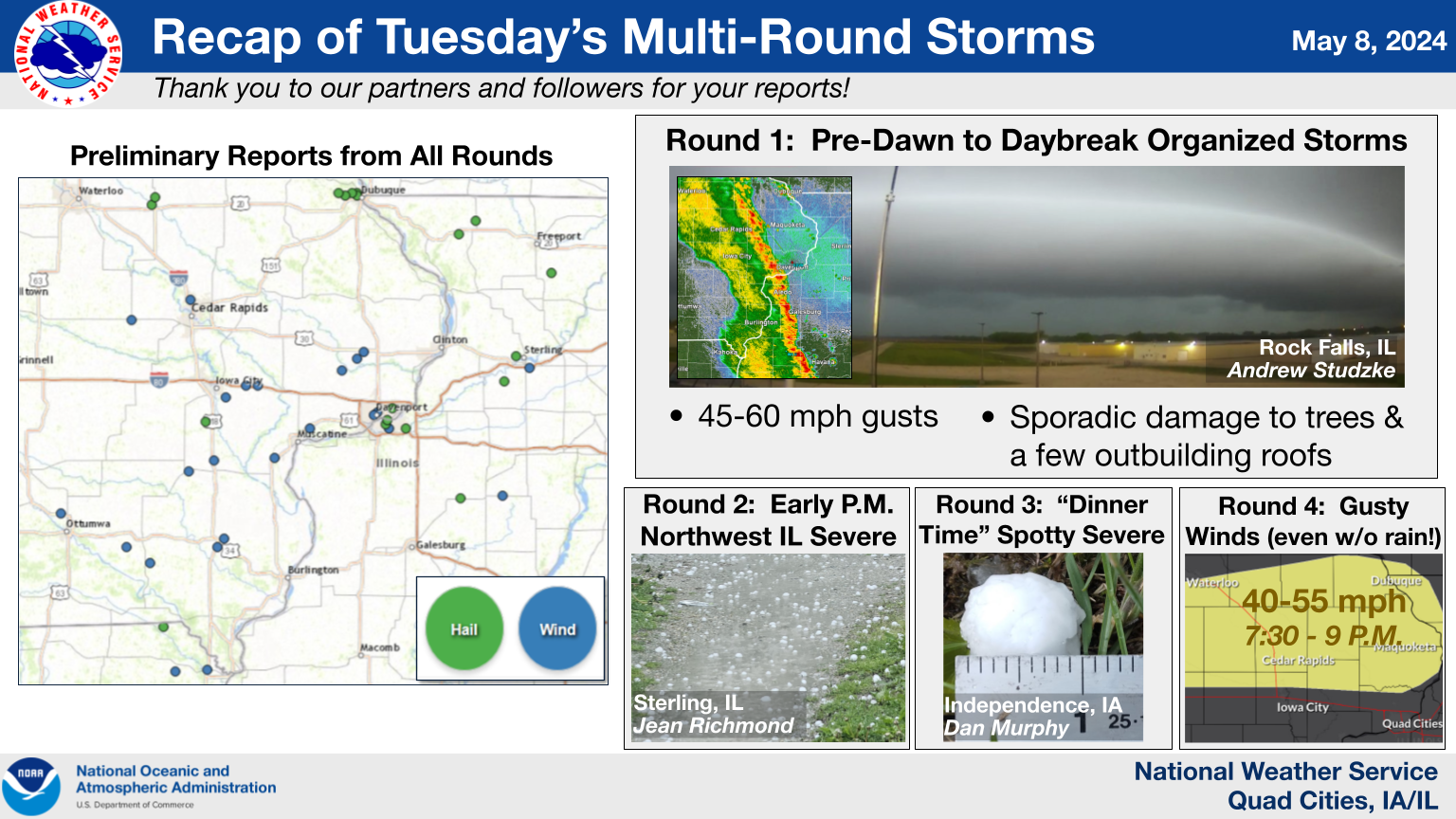
Storm Reports...Summary
Preliminary Local Storm Report...Summary
National Weather Service Quad Cities IA IL
1141 PM CDT Tue May 7 2024

..TIME...   ...EVENT...      ...CITY LOCATION...     ...LAT.LON...
..DATE...   ....MAG....      ..COUNTY LOCATION..ST.. ...SOURCE....
            ..REMARKS..

0302 AM     Tstm Wnd Dmg     3 S Medill              40.39N 91.77W
05/07/2024                   Clark              MO   Public

            Tree down on road SE of Kahoka. Time based
            on radar.

0305 AM     Tstm Wnd Gst     4 WSW Newhall           41.96N 92.03W
05/07/2024  M63 MPH          Benton             IA   Dept of Highways

            Van Horne RWIS at US 30 and IA218.

0323 AM     Tstm Wnd Dmg     1 NNE Wayland           40.40N 91.58W
05/07/2024                   Clark              MO   Public

            Metal sections of garage roof removed and
            blown into field. Time estimated based on
            radar. Report from social media.

0330 AM     Tstm Wnd Dmg     1 S Washington          41.29N 91.69W
05/07/2024                   Washington         IA   Public

            Numerous reports of branches down on south
            side of town along with a couple of trees.
            Time based on radar.

0335 AM     Non-Tstm Wnd Gst 1 S Washington Airport  41.27N 91.67W
05/07/2024  M51 MPH          Washington         IA   AWOS

            AWOS station KAWG Washington Arpt.

0335 AM     Tstm Wnd Dmg     3 NE Mount Pleasant Mun 40.99N 91.48W
05/07/2024                   Henry              IA   Public

            Trees down between Mt Union and Mt Pleasant.

0335 AM     Tstm Wnd Gst     Mount Pleasant Municipa 40.95N 91.52W
05/07/2024  M58 MPH          Henry              IA   AWOS

            AWOS station KMPZ Mount Pleasant Arpt.

0345 AM     Tstm Wnd Dmg     1 WNW Haskins           41.34N 91.54W
05/07/2024                   Washington         IA   Public

            Tree down. Report from Social Media.

0358 AM     Hail             2 NNW Riverside         41.51N 91.59W
05/07/2024  M0.88 Inch       Johnson            IA   Trained Spotter

            45 to 50 mph winds as well.

0401 AM     Tstm Wnd Dmg     4 SE Iowa City          41.62N 91.47W
05/07/2024                   Johnson            IA   Public

            Branches down at this location. Report from
            Social Media.

0406 AM     Non-Tstm Wnd Gst 1 S Burlington Regional 40.77N 91.13W
05/07/2024  M51 MPH          Des Moines         IA   ASOS

            ASOS station KBRL Burlington Arpt.

0408 AM     Tstm Wnd Dmg     2 SW Muscatine Municipa 41.35N 91.18W
05/07/2024                   Muscatine          IA   Storm Chaser

            2 to 4 inch diameter branches down.

0413 AM     Tstm Wnd Dmg     West Branch             41.67N 91.35W
05/07/2024                   Cedar              IA   Public

            Trees down in West Branch. Time based on
            radar.

0420 AM     Tstm Wnd Gst     1 WNW Springdale        41.67N 91.28W
05/07/2024  M57 MPH          Cedar              IA   Mesonet

            measured 56 mph gust on a home weather
            station.

0435 AM     Tstm Wnd Gst     2 S Sweetland Center    41.48N 90.97W
05/07/2024  M62 MPH          Muscatine          IA   Storm Chaser


0455 AM     Tstm Wnd Dmg     2 SE Davenport          41.54N 90.59W
05/07/2024                   Scott              IA   Public

            Large tree limbs down on a house. Public
            report via social media. Time estimated by
            radar.

0456 AM     Tstm Wnd Dmg     2 ESE Davenport         41.55N 90.57W
05/07/2024                   Scott              IA   Public

            Numerous branches down near Vanderveer Park.
            Some branches several inches thick.

0456 AM     Tstm Wnd Dmg     Dixon                   41.74N 90.78W
05/07/2024                   Scott              IA   Public

            Large tree down along with small branches
            through town. Time based on radar.

0501 AM     Tstm Wnd Dmg     1 WSW Moline            41.48N 90.50W
05/07/2024                   Rock Island        IL   Public

            5 inch diameter branch down at location.
            Time based on radar.

0503 AM     Non-Tstm Wnd Gst Davenport Municipality  41.62N 90.58W
05/07/2024  M49 MPH          Scott              IA   ASOS

            ASOS station KDVN Davenport Arpt.

0503 AM     Tstm Wnd Dmg     Grand Mound             41.82N 90.65W
05/07/2024                   Clinton            IA   Public

            Many tree branches down in Grand Mound. Time
            estimated from radar.

0503 AM     Tstm Wnd Dmg     3 SW Grand Mound        41.79N 90.69W
05/07/2024                   Clinton            IA   Public

            Damage to the roof of a building. Owner says
            the roof paneling is rated to 90 MPH.

0517 AM     Hail             2 WSW Riverdale         41.52N 90.51W
05/07/2024  M1.00 Inch       Scott              IA   Public


0645 AM     Non-Tstm Wnd Gst 1 SE Lowden             41.85N 90.90W
05/07/2024  M51 MPH          Cedar              IA   Mesonet

            Mesonet station UR422 Lowden.

0855 AM     Rain             Carthage                40.41N 91.13W
05/07/2024  M1.00 Inch       Hancock            IL   Trained Spotter


1224 PM     Hail             4 NW Tampico            41.69N 89.82W
05/07/2024  M1.00 Inch       Whiteside          IL   Public


1233 PM     Hail             Grimes Addition         41.80N 89.75W
05/07/2024  M1.00 Inch       Whiteside          IL   Public


0409 PM     Hail             1 WNW Independence      42.47N 91.91W
05/07/2024  M1.00 Inch       Buchanan           IA   Public


0413 PM     Hail             2 N Independence        42.50N 91.89W
05/07/2024  M1.00 Inch       Buchanan           IA   Public

            Spotter measured quarter size hail at this
            location.

0615 PM     Hail             Lore                    42.52N 90.80W
05/07/2024  E1.00 Inch       Dubuque            IA   Trained Spotter

            Spotter reported hail went from nickel size
            to now quarter size.

0628 PM     Hail             1 N Dubuque             42.52N 90.69W
05/07/2024  E1.00 Inch       Dubuque            IA   Trained Spotter

            Trained Spotter reported quarter size hail
            at the Amazon facility in Dubuque.

0649 PM     Tstm Wnd Gst     1 E Whiteside County Ai 41.75N 89.67W
05/07/2024  M48 MPH          Whiteside          IL   AWOS

            AWOS station KSQI Sterling/Rock Falls Arpt.

0709 PM     Hail             3 ESE Woodbine          42.34N 90.09W
05/07/2024  M0.88 Inch       Jo Daviess         IL   Public

            Mostly pea sized hail but a few stones were
            a little larger than a penny.
Media use of NWS Web News Stories is encouraged!
Please acknowledge the NWS as the source of any news information accessed from this site.
Our past events page can be found at weather.gov/dvn/events.

