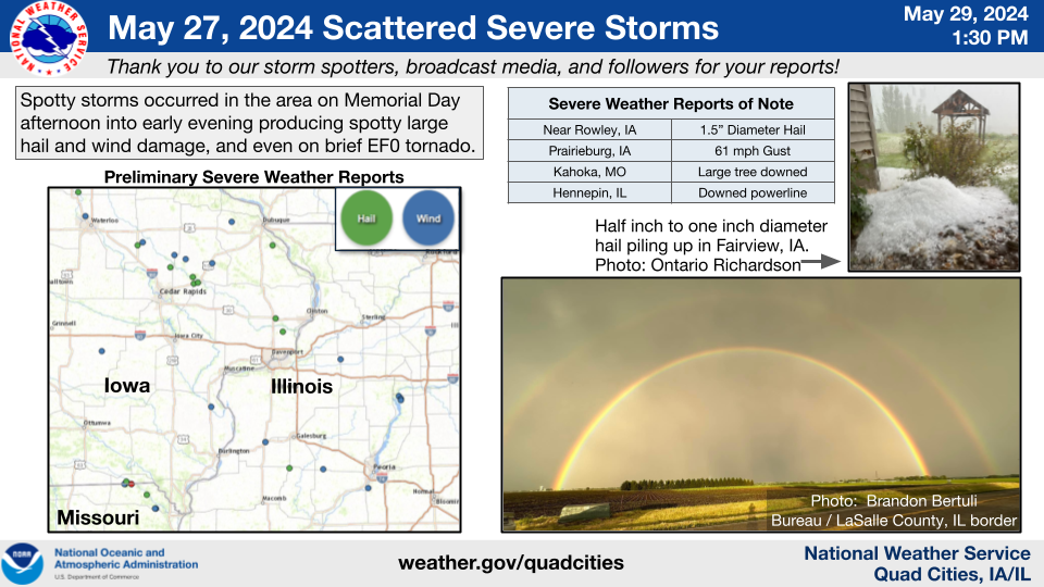
Storm Reports...Summary
Preliminary Local Storm Report...Summary
National Weather Service Quad Cities IA IL

..TIME...   ...EVENT...      ...CITY LOCATION...     ...LAT.LON...
..DATE...   ....MAG....      ..COUNTY LOCATION..ST.. ...SOURCE....
            ..REMARKS..

0300 PM     Hail             3 WSW Rowley            42.35N 91.89W
05/27/2024  E1.50 Inch       Buchanan           IA   Public

            Time and location estimated from a public
            report received on Facebook.

0340 PM     Hail             2 WSW Central City      42.19N 91.57W
05/27/2024  E1.00 Inch       Linn               IA   Trained Spotter

            Time estimated from radar.

0357 PM     Tstm Wnd Dmg     4 W Millersburg         41.58N 92.24W
05/27/2024                   Iowa               IA   911 Call Center

            County 911 dispatch reported a downed tree
            with wind speeds that were estimated to be
            50 to 60 mph. Time estimated by radar.

0402 PM     Hail             Stone City              42.12N 91.35W
05/27/2024  E1.25 Inch       Jones              IA   Public

            Report relayed via Facebook. Time estimated
            by radar.

0410 PM     Hail             1 S Fairview            42.07N 91.34W
05/27/2024  E1.00 Inch       Jones              IA   Public

            Report from social media estimating quarter
            sized hail, along with a bunch of
            accumulating small hail.
0425 PM     Tstm Wnd Dmg     Rowley                  42.37N 91.84W
05/27/2024                   Buchanan           IA   Public

            Social media report of several trees down in
            the town of Rowley. Time estimated by radar.

0446 PM     Tstm Wnd Dmg     Coggon                  42.28N 91.53W
05/27/2024                   Linn               IA   Trained Spotter

            Large tree limb downed by thunderstorm wind
            gusts.

0455 PM     Tstm Wnd Gst     1 NNE Prairieburg       42.25N 91.42W
05/27/2024  M61 MPH          Linn               IA   Public

            Personal weather station. Time estimated
            from radar.

0515 PM     Tstm Wnd Gst     1 S Monticello Municipa 42.22N 91.16W
05/27/2024  M51 MPH          Jones              IA   AWOS


0530 PM     Tstm Wnd Gst     1 NW Bankston           42.52N 90.97W
05/27/2024  M52 MPH          Dubuque            IA   Trained Spotter


0530 PM     Hail             1 E Dewitt              41.82N 90.54W
05/27/2024  M0.70 Inch       Clinton            IA   Public


0534 PM     Tstm Wnd Dmg     1 ESE Wapello           41.17N 91.17W
05/27/2024                   Louisa             IA   Trained Spotter

            Large branch down.
0538 PM     Tornado          3 WNW Charlie Heath Mem 40.60N 91.95W
05/27/2024                   Scotland           MO   NWS Storm Survey

            A brief tornado caused outbuilding and tree
            damage at a rural residence early Monday
            evening. A trained spotter also observed a
            narrow, short path through grass and a tree
            line. The tornado had maximum winds around
            85 mph and was rated EF-0. There were no
            injuries.

0540 PM     Hail             3 W Mount Sterling      40.62N 92.00W
05/27/2024  E0.70 Inch       Van Buren          IA   Trained Spotter

            Winds also estimated to 40 mph.

0542 PM     Hail             2 SW Mccausland         41.72N 90.47W
05/27/2024  E1.00 Inch       Scott              IA   Broadcast Media

            Time estimated by radar.

0545 PM     Tstm Wnd Dmg     3 NNE Azen              40.60N 92.02W
05/27/2024                   Scotland           MO   Trained Spotter

            Damage to cars, outbuildings and trees, and
            debris driven into siding of house. Swirl
            marks noted in grass. Possible brief
            tornado.

0545 PM     Hail             3 NNE Azen              40.60N 92.01W
05/27/2024  E1.00 Inch       Scotland           MO   Trained Spotter

            Time estimated from radar.

0545 PM     Hail             1 SW Mount Sterling     40.60N 91.95W
05/27/2024  M1.00 Inch       Scotland           MO   Public

            Wind damage was also noted from this storm
            to sheds, houses, and trees.

0600 PM     Hail             Chambersburg            40.52N 91.80W
05/27/2024  E1.00 Inch       Clark              MO   Public

            Time estimated by radar.

0620 PM     Tstm Wnd Dmg     Kahoka                  40.42N 91.71W
05/27/2024                   Clark              MO   911 Call Center

            Corrects previous tstm wnd dmg report from
            Kahoka. 911 dispatch center reported one
            large tree down in the town of Kahoka. Time
            estimated by radar. There was also lots of
            small hail with the largest size being the
            size of dimes.

0622 PM     Tstm Wnd Dmg     Monmouth                40.91N 90.64W
05/27/2024                   Warren             IL   Public

            Report gathered from social media of a few
            three inch diameter tree branches downed by
            the thunderstorm winds. Time estimated by
            radar.

0630 PM     Tstm Wnd Gst     Hooppole                41.52N 89.91W
05/27/2024  E60 MPH          Henry              IL   Trained Spotter

            Atleast 60 mph winds.

0720 PM     Tstm Wnd Dmg     2 WSW Florid            41.22N 89.32W
05/27/2024                   Putnam             IL   Trained Spotter

            Report on social media from a trained
            spotter of a large tree limb down across the
            road. At least 8 to 10 inches in diameter.
            Time estimated by radar.

0720 PM     Tstm Wnd Dmg     2 S Hennepin            41.23N 89.32W
05/27/2024                   Putnam             IL   Public

            12 inch diameter tree down across Illinois
            Highway 26. Time estimated by radar.

0720 PM     Tstm Wnd Dmg     1 WSW Hennepin          41.25N 89.34W
05/27/2024                   Putnam             IL   Trained Spotter

            8 inch diameter tree limb broke off of a
            tree and took down a powerline. Reported
            from a trained spotter on social media, with
            time estimated by radar.
Media use of NWS Web News Stories is encouraged!
Please acknowledge the NWS as the source of any news information accessed from this site.
Our past events page can be found at weather.gov/dvn/events.