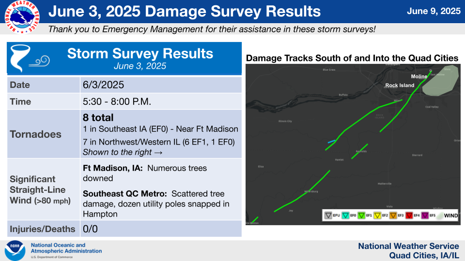
|
||
Photos
 |
 |
 |
| Fort Madison, IA - NWS Storm Survey | ~30 stack train cars blown over in background. SW of Fort Madison, IA - NWS Storm Survey | Monmouth, IL - NWS Storm Survey |
 |
 |
 |
| Monmouth, IL - NWS Storm Survey | New Boston, IL - NWS Storm Survey | Millersburg, IL - NWS Storm Survey |
 |
 |
 |
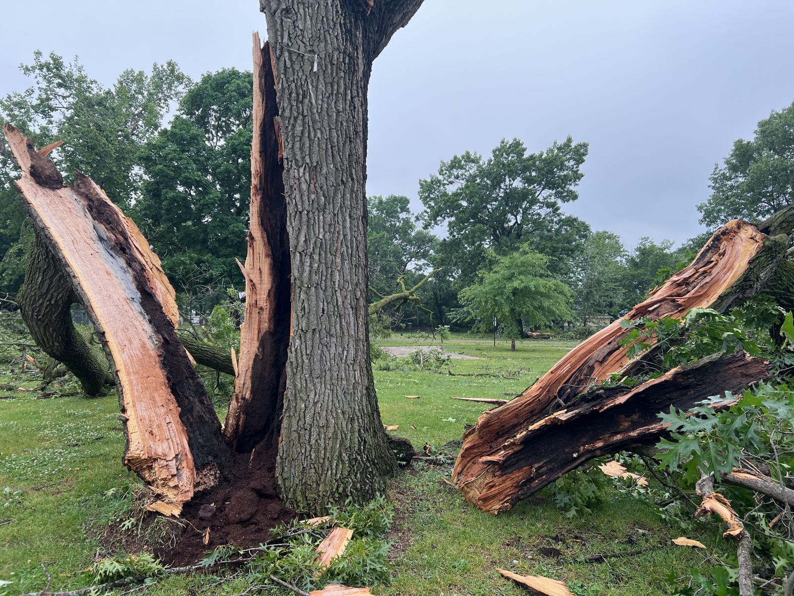
| Taylor Ridge, IL - NWS Storm Survey | Taylor Ridge, IL - NWS Storm Survey | Coyne Center, IL - NWS Storm Survey |
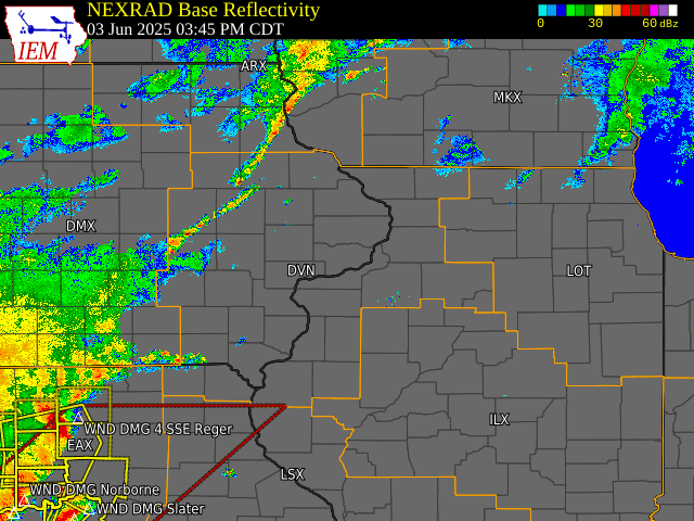
Radar
 |
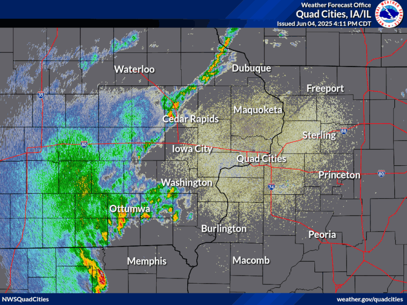 |
| IEM Radar Loop (Iowa State University) | Clear Radar Loop DVN |
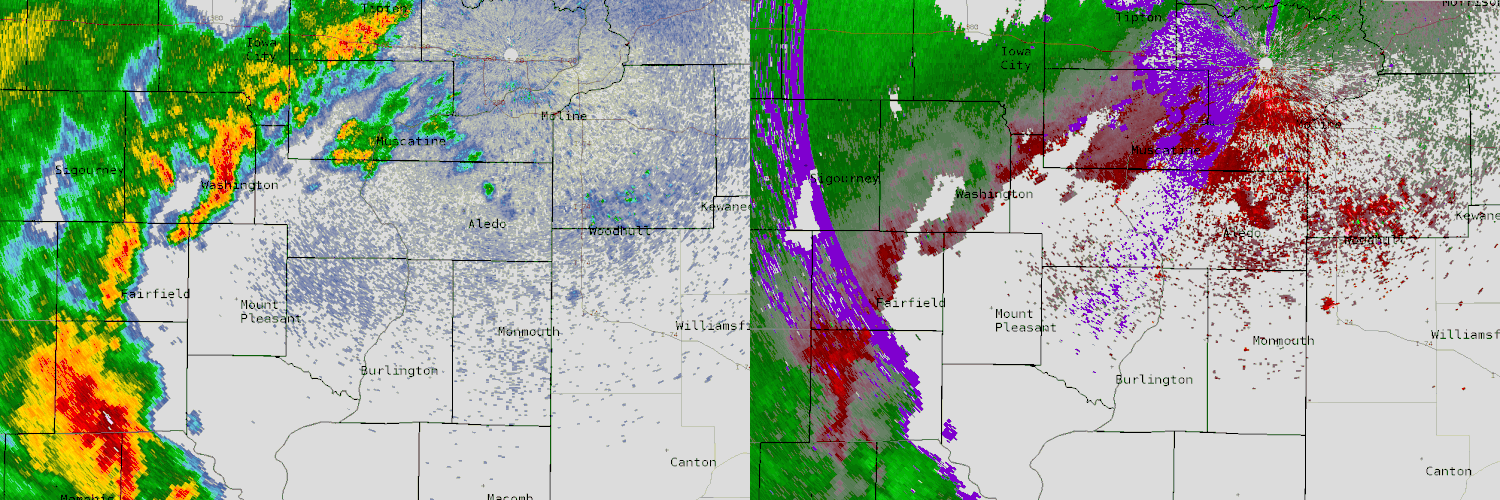 |
| Broad View of Reflectivity and Storm Relative Velocity |
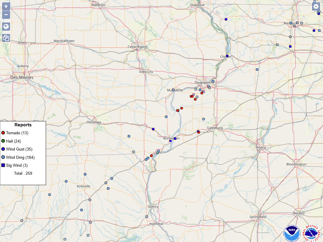
Storm Reports
|
Storm Report Map of County Warning Area and Adjacent Areas Note numbers of reports on key are nationwide totals from June 3, 2025 |
 |
| SPC Severe Weather Event Review for Tuesday June 3, 2025 |
Preliminary Local Storm Report...Summary
National Weather Service Quad Cities IA IL
1034 PM CDT Wed Jun 4 2025
..TIME... ...EVENT... ...CITY LOCATION... ...LAT.LON...
..DATE... ....MAG.... ..COUNTY LOCATION..ST.. ...SOURCE....
..REMARKS..
0500 PM Tstm Wnd Dmg 1 SE Sand Hill 40.30N 92.11W
06/03/2025 Scotland MO Trained Spotter
Trees down.
0655 PM Tstm Wnd Gst Fulton 41.86N 90.16W
06/03/2025 M59 MPH Whiteside IL Public
Wind gust of 60 mph recorded on home weather
station.
0815 PM Tstm Wnd Dmg 5 SSE Whiteside County 41.69N 89.66W
06/03/2025 Whiteside IL Emergency Mngr
Time estimate by radar. Power lines have
been downed by the thunderstorm winds.
1154 AM Rain 3 ENE Garden Plain 41.81N 90.08W
06/04/2025 M2.75 Inch Whiteside IL Trained Spotter
Storm Total.
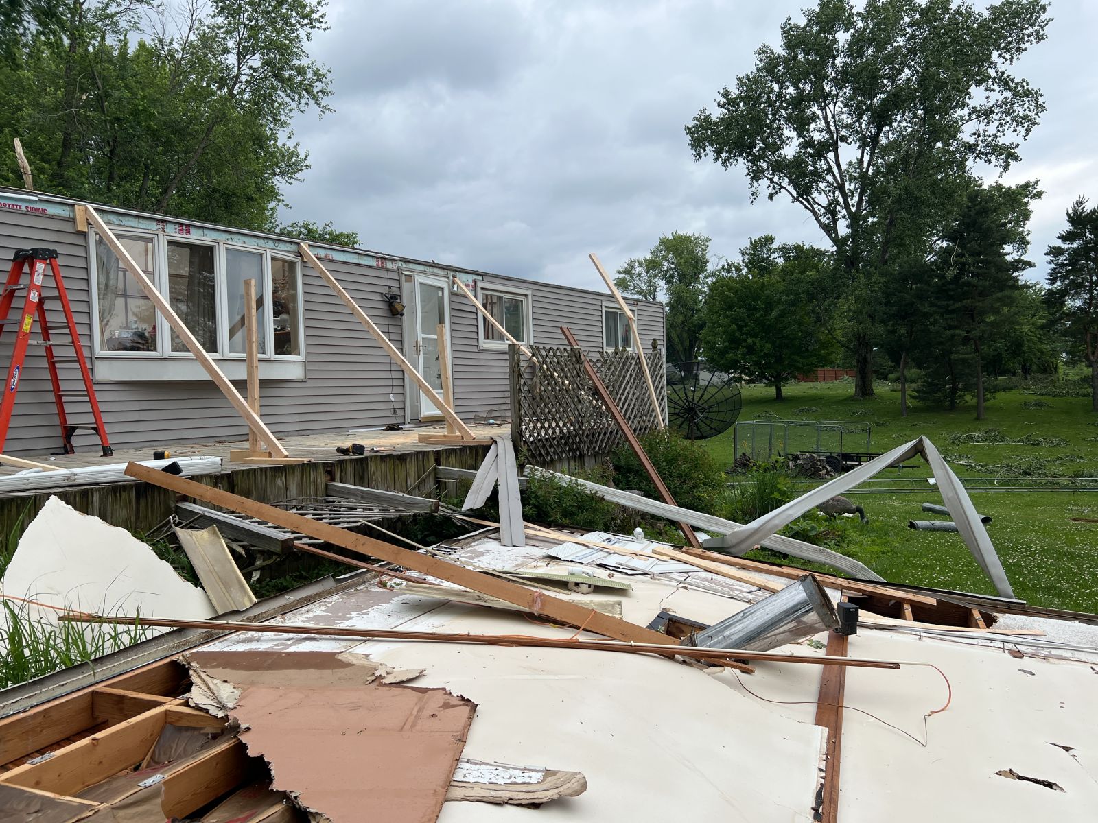
0646 PM Tornado 1 S Monmouth 40.89N 90.64W
06/03/2025 Warren IL NWS Storm Survey
An EF1 tornado with maximum wind speeds of
100 mph touched down on the south side of
Monmouth, and move northeast through town,
damaging trees, sheds, and a garage. A roof
was torn off a mobile home, and roof damaged
on a house.
0648 PM Tstm Wnd Gst 1 SSW Monmouth 40.90N 90.65W
06/03/2025 E60 MPH Warren IL Amateur Radio
50 to 60 mph wind gusts with torrential
rain. Relayed from HAM radio.
0705 PM Tstm Wnd Dmg Alexis 41.06N 90.56W
06/03/2025 Warren IL Trained Spotter
Widespread wind damage with reports of shed
roofs ripped off and large trees down.
1000 PM Rain 2 W Bolton 42.26N 89.77W
06/03/2025 M2.30 Inch Stephenson IL Trained Spotter
Storm total.
0709 AM Rain 2 W Freeport 42.30N 89.66W
06/04/2025 M3.50 Inch Stephenson IL Trained Spotter
Storm total.
0737 AM Rain 3 SW Winneshiek 42.32N 89.57W
06/04/2025 M4.00 Inch Stephenson IL Trained Spotter
Storm total.
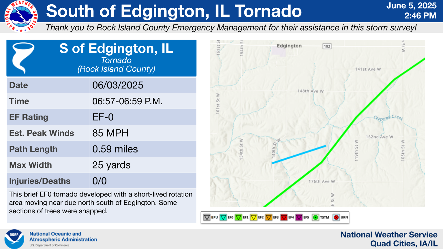
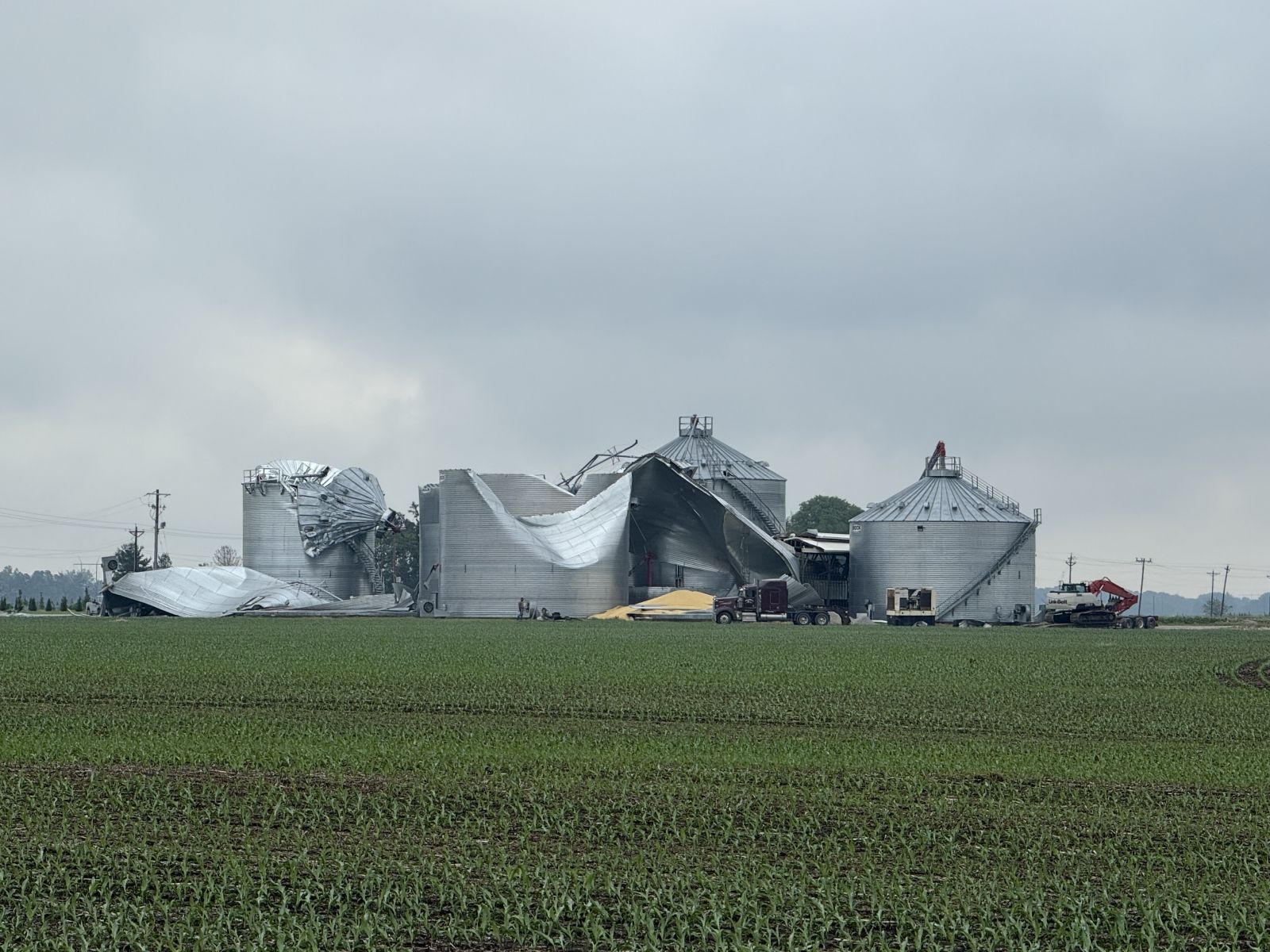
0657 PM Tornado 2 S Edgington 41.35N 90.77W
06/03/2025 Rock Island IL NWS Storm Survey
This EF1 tornado developed southwest of
Taylor Ridge and crossed Illinois 192, doing
heavy damage to three large empty grain bins
and destroying an outbuilding. Damage done
to trees as well.
0657 PM Tornado 2 NNW Hamlet 41.35N 90.75W
06/03/2025 Rock Island IL NWS Storm Survey
This brief EF0 tornado developed with a
short-lived rotation area moving near due
north south of Edgington. Some sections of
trees were snapped.
0701 PM Tstm Wnd Dmg Reynolds 41.34N 90.67W
06/03/2025 Rock Island IL Public
Numerous tree branches down.
0702 PM Tstm Wnd Dmg 2 ESE Edgington 41.37N 90.73W
06/03/2025 Rock Island IL Broadcast Media
Grain bins damaged. Possible tornado. Time
estimated from radar data.
0710 PM Tstm Wnd Dmg 2 E Andalusia 41.44N 90.69W
06/03/2025 Rock Island IL Public
One half of large tree down. Time estimated
from radar information.
0710 PM Tstm Wnd Dmg 1 NE Coyne Center 41.41N 90.56W
06/03/2025 Rock Island IL Public
Numerous trees down. Possible tornado. Time
estimated from radar data.
0710 PM Tstm Wnd Dmg Oak Grove 41.41N 90.57W
06/03/2025 Rock Island IL Emergency Mngr
Significant damage to mobile homes. Time
estimated based on radar.
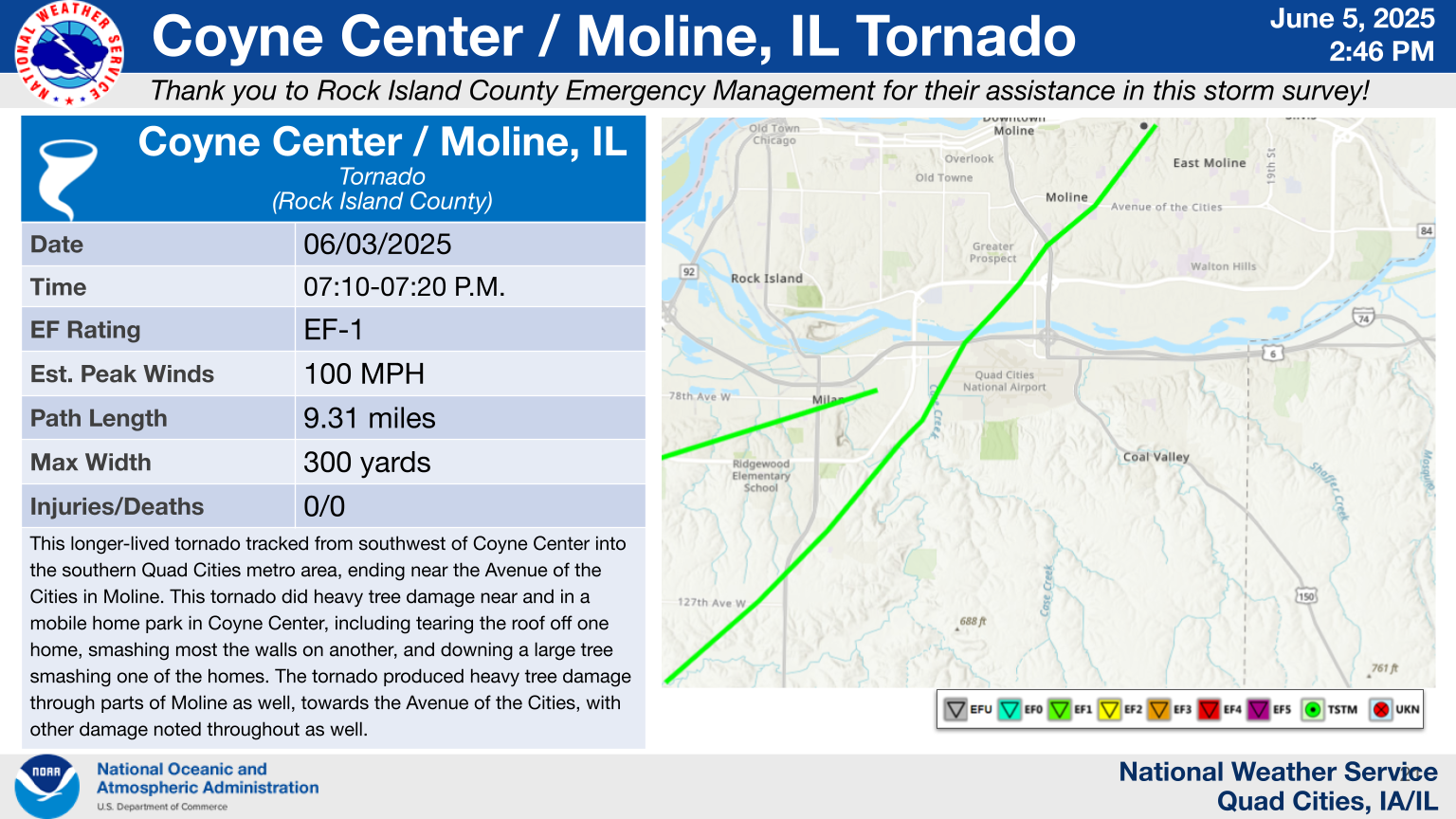
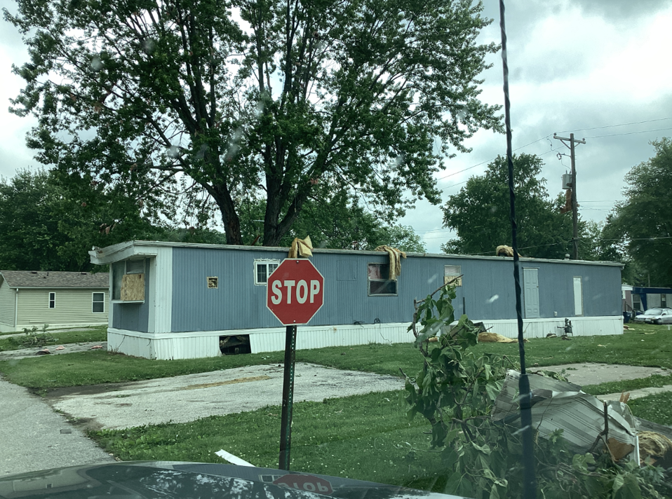
0710 PM Tornado 1 SW Coyne Center 41.39N 90.59W
06/03/2025 Rock Island IL NWS Storm Survey
This longer lived EF1 tornado tracked from
southwest of Coyne Center into the southern
Quad Cities metro area ending near the
Avenue of the Cities in Moline. This tornado
did heavy tree damage near and in a mobile
home park in Coyne Center, including tearing
the roof off one home, smashing most the
walls on another, and downing a large tree
smashing one of the homes. The tornado
appeared to pass just on the western side of
the Quad Cities International Airport before
crossing I-280. The tornado produced heavy
tree damage on the north side of the Rock
River, including some trees downed onto
garages / sheds. The tornado would pass very
close if not partially over SouthPark mall
in Moline, causing damage to numerous trees
in the parking lot, and damaging nearby
commercial signs and windows. Windows were
also reported blown out in several cars at a
business.
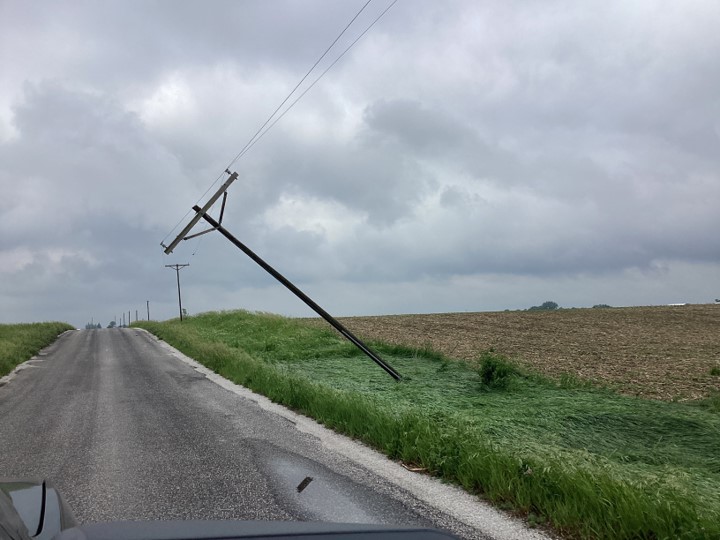
0712 PM Tstm Wnd Dmg 2 WNW Oak Grove 41.43N 90.62W
06/03/2025 Rock Island IL Public
Power pole broken off. Relayed by media.
Time estimated from radar data.
0716 PM Tstm Wnd Dmg 1 NW Coal Valley 41.46N 90.46W
06/03/2025 Rock Island IL Public
Half of a large tree down.
0722 PM Tstm Wnd Dmg 1 ESE Moline 41.48N 90.48W
06/03/2025 Rock Island IL Trained Spotter
Large Tree Down.
0728 PM Tstm Wnd Dmg 1 SSE Hampton 41.54N 90.40W
06/03/2025 Rock Island IL Public
12 Power poles snapped off. Time estimated
from radar information.
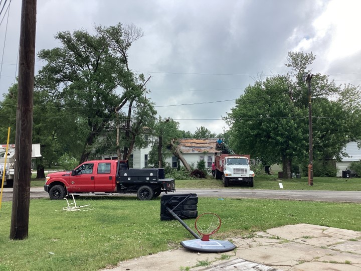
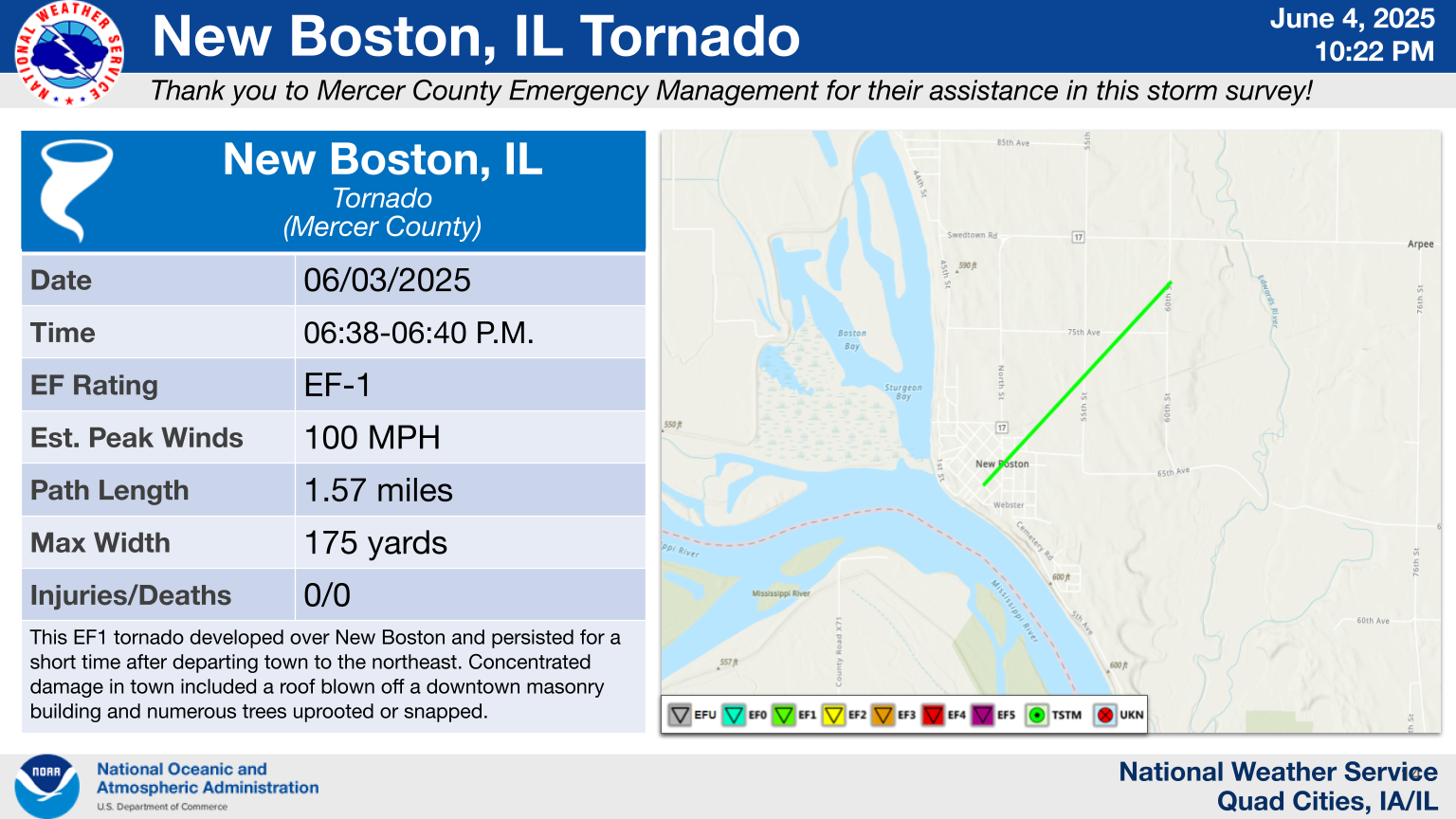
0635 PM Tstm Wnd Dmg New Boston 41.17N 90.99W
06/03/2025 Mercer IL Public
Large tree branches down throughout town,
some whole trees down. Time estimated from
radar data.
0638 PM Tornado New Boston 41.17N 91.00W
06/03/2025 Mercer IL NWS Storm Survey
This EF1 tornado developed over New Boston
and persisted for a short time after
departing town to the northeast.
Concentrated damage in town included a roof
blown off a downtown masonry building and
numerous trees uprooted or snapped.
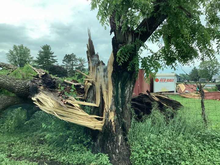
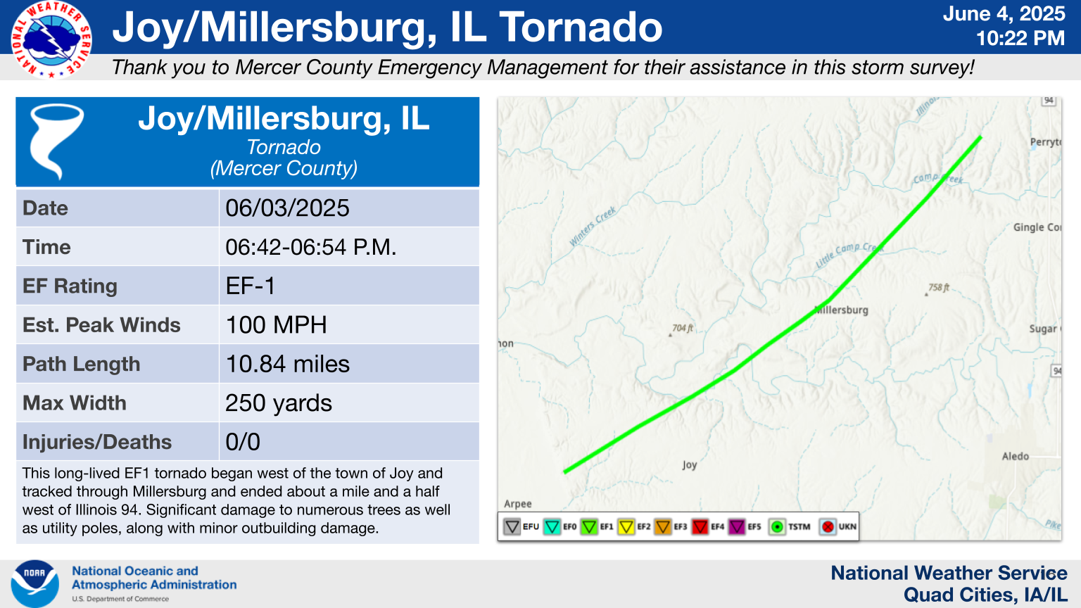
0642 PM Tornado 3 W Joy 41.20N 90.93W
06/03/2025 Mercer IL NWS Storm Survey
This long-lived EF1 tornado began west of
the town of Joy and tracked through
Millersburg and ended about a mile and a
half west of Illinois 94. Significant damage
to numerous trees as well as utility poles,
along with minor outbuilding damage.
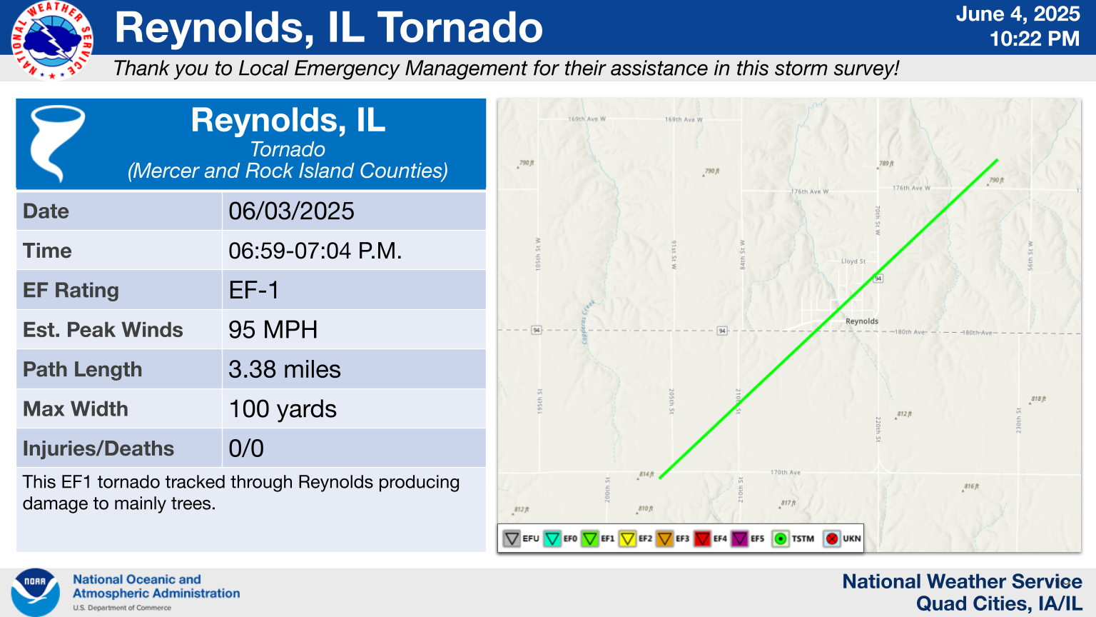
0659 PM Tornado 2 E Hamlet 41.31N 90.70W
06/03/2025 Mercer IL NWS Storm Survey
This EF1 tornado tracked through Reynolds
producing damage to mainly trees.
0751 AM Rain 5 NW Industry 40.37N 90.67W
06/04/2025 M1.50 Inch McDonough IL Trained Spotter
Storm total.
0640 PM Tstm Wnd Gst 2 SW Lone Tree 40.81N 91.04W
06/03/2025 M72 MPH Henderson IL Trained Spotter
0640 AM Rain Carthage 40.41N 91.13W
06/04/2025 M2.30 Inch Hancock IL Trained Spotter
Storm total.
0626 PM Rain 3 W Mount Sterling 40.62N 92.00W
06/03/2025 M2.00 Inch Van Buren IA Trained Spotter
1025 PM Rain Cantril 40.64N 92.07W
06/03/2025 M1.00 Inch Van Buren IA Trained Spotter
0530 AM Rain 2 NNE Credit Island 41.52N 90.60W
06/04/2025 U2.20 Inch Scott IA Trained Spotter
Storm total.
0530 AM Rain 2 NNE Credit Island 41.52N 90.60W
06/04/2025 M2.20 Inch Scott IA Trained Spotter
Storm total.
0700 AM Rain 1 NE Bettendorf 41.58N 90.47W
06/04/2025 M2.00 Inch Scott IA Trained Spotter
Storm total.
0724 AM Rain 1 W Bettendorf 41.56N 90.49W
06/04/2025 M2.19 Inch Scott IA Trained Spotter
Storm total.
0838 AM Rain 1 NW Davenport 41.56N 90.62W
06/04/2025 M2.30 Inch Scott IA Trained Spotter
storm total rain fall report.
0854 AM Rain Le Claire 41.60N 90.36W
06/04/2025 M2.40 Inch Scott IA Trained Spotter
1121 AM Rain Walcott 41.59N 90.77W
06/04/2025 M1.75 Inch Scott IA Public
Storm total.
0646 PM Tstm Wnd Dmg 1 NNE Muscatine 41.43N 91.07W
06/03/2025 Muscatine IA Emergency Mngr
Trees down in Muscatine. Time estimated from
radar data.
0622 PM Tstm Wnd Dmg Newport 41.09N 91.19W
06/03/2025 Louisa IA Amateur Radio
Farm shed destroyed. Time estimated from
radar data.
0551 PM Tstm Wnd Dmg 2 ENE Argyle 40.54N 91.53W
06/03/2025 Lee IA Law Enforcement
Train derailed near New Boston. second of
two separate trains derailed in area. 30
cars derailed. Time estimated from radar
data.
0552 PM Tstm Wnd Dmg New Boston 40.56N 91.50W
06/03/2025 Lee IA Law Enforcement
Train derailed near New Boston. One of two
separate train derailed in area. Time
estimated from radar data.
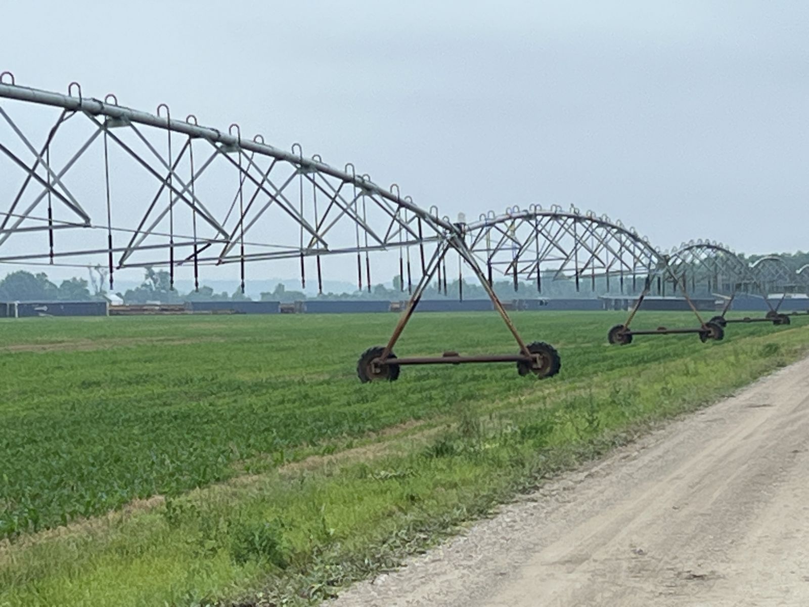
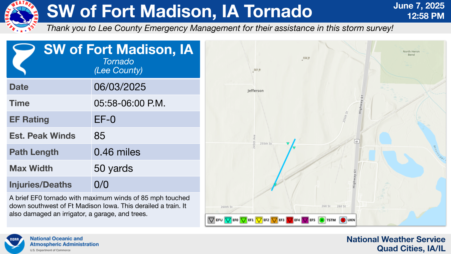
0558 PM Tornado 4 ENE New Boston 40.59N 91.44W
06/03/2025 Lee IA NWS Storm Survey
A brief EF0 tornado with maximum winds of 80
mph touched down southwest of Ft Madison
Iowa. This damaged an irrigator, a garage,
and trees.
0605 PM Tstm Wnd Dmg 1 NE Fort Madison 40.63N 91.34W
06/03/2025 Lee IA Law Enforcement
Widespread tree damage throughout all of
Fort Madison from 53rd street to 6th street.
Trees down on houses, trees on roads. Time
estimated from radar data.
0607 PM Tstm Wnd Dmg 1 SE Fort Madison Munic 40.65N 91.32W
06/03/2025 Lee IA Law Enforcement
Numerous trees down at Rodeo Park. Time
estimated from radar information.
0630 PM Tstm Wnd Gst New London 40.93N 91.41W
06/03/2025 M62 MPH Henry IA Mesonet
0625 PM Tstm Wnd Gst Burlington Regional Air 40.78N 91.12W
06/03/2025 M81 MPH Des Moines IA ASOS
0600 AM Rain 5 SE Sperry 40.89N 91.10W
06/04/2025 M1.13 Inch Des Moines IA Trained Spotter
Storm total.
0704 AM Rain 2 SW Yarmouth 41.01N 91.35W
06/04/2025 M1.64 Inch Des Moines IA Trained Spotter
Storm total.
0926 AM Rain 1 ENE Clinton 41.85N 90.21W
06/04/2025 M1.90 Inch Clinton IA Trained Spotter
Storm total.
0928 AM Rain 2 W Fulton 41.86N 90.19W
06/04/2025 M1.80 Inch Clinton IA Trained Spotter
Storm total.
Rain Reports
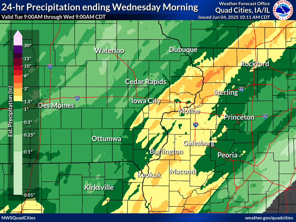 |
COCORAHS PRECIPITATION SUMMARY
NATIONAL WEATHER SERVICE QUAD CITIES IA IL
1038 AM CDT WED JUN 4 2025

...COCORAHS PRECIPITATION REPORTS...

THESE REPORTS ARE CONSIDERED SUPPLEMENTAL AND UNOFFICIAL
VALUES ARE FOR THE PREVIOUS 24 HOURS ENDING AROUND 7 AM LOCAL TIME

FOR MORE INFORMATION ON THE COCORAHS PROGRAM, PLEASE VISIT
WWW.COCORAHS.ORG

.B DVN 0604 C DH07/PP/SF/SD/SW
:
:
:COCORAHS PRECIPITATION REPORTS IN ILLINOIS
:
:                                             SNOW   SNOW    WATER
:                                      PCPN   FALL   DEPTH   EQUIV
:
IL-CR-25   : LANARK 0.3 SSW          : 3.68 /   MM /    MM /    MM
IL-SP-07   : DAVIS 0.5 N             : 3.22 /   MM /    MM /    MM
IL-CR-18   : LANARK 6.0 E            : 3.13 /   MM /    MM /    MM
IL-SP-32   : DAVIS 1.5 NNE           : 3.01 /  0.0 /   0.0 /    MM
IL-CR-19   : LANARK 1.6 SSE          : 2.90 /   MM /    MM /    MM
IL-CR-23   : SHANNON 2.7 E           : 2.85 /   MM /    MM /    MM
IL-CR-20   : LANARK 5.3 N            : 2.62 /   MM /    MM /    MM
IL-SP-28   : FREEPORT 4.3 W          : 2.62 /   MM /    MM /    MM
IL-CR-22   : LANARK 4.2 NNW          : 2.34 /   MM /    MM /    MM
IL-SP-22   : FREEPORT 1.3 E          : 2.10 /   MM /    MM /    MM
IL-HN-07   : LA HARPE 0.7 E          : 1.93 /  0.0 /   0.0 /    MM
IL-RI-22   : ILLINOIS CITY 6.7 SW    : 1.92 /   MM /    MM /    MM
IL-HN-02   : WARSAW 5.8 SE           : 1.90 /   MM /    MM /    MM
IL-WD-05   : MORRISON 3.2 E          : 1.85 /   MM /    MM /    MM
IL-HY-25   : GALVA 0.9 SE            : 1.81 /   MM /    MM /    MM
IL-HD-01   : STRONGHURST 0.4 SSW     : 1.71 /   MM /    MM /    MM
IL-JD-15   : STOCKTON 5.9 WNW        : 1.70 /   MM /    MM /    MM
IL-HY-13   : GALVA 2.7 NE            : 1.66 /   MM /    MM /    MM
IL-JD-13   : STOCKTON 4.6 NW         : 1.65 /   MM /    MM /    MM
IL-HY-28   : GALVA 0.4 NW            : 1.60 /   MM /    MM /    MM
IL-HN-01   : DALLAS CITY 3.0 SSE     : 1.55 /  0.0 /   0.0 /  0.00
IL-RI-24   : TAYLOR RIDGE 1.1 N      : 1.52 /   MM /    MM /    MM
IL-HY-30   : COLONA 0.5 ESE          : 1.50 /   MM /    MM /    MM
IL-RI-27   : ROCK ISLAND 2.0 ENE     : 1.50 /   MM /    MM /    MM
IL-WR-07   : MONMOUTH 0.4 SE         : 1.48 /   MM /    MM /    MM
IL-MCD-06  : MACOMB 3.8 NW           : 1.45 /   MM /    MM /    MM
IL-SP-31   : LENA 0.3 SSE            : 1.45 /   MM /    MM /    MM
IL-HY-06   : NEW WINDSOR 2.0 N       : 1.43 /   MM /    MM /    MM
IL-WD-24   : STERLING 5.9 NNE        : 1.42 /   MM /    MM /    MM
IL-WD-14   : STERLING 4.9 WSW        : 1.38 /   MM /    MM /    MM
IL-MCD-07  : COLCHESTER 3.5 NE       : 1.37 /   MM /    MM /    MM
IL-WD-18   : PROPHETSTOWN 0.2 SW     : 1.37 /   MM /    MM /    MM
IL-HY-11   : WOODHULL 0.3 ESE        : 1.36 /   MM /    MM /    MM
IL-JD-17   : STOCKTON 4.5 N          : 1.34 /   MM /    MM /    MM
IL-JD-06   : HANOVER 0.2 NW          : 1.30 /   MM /    MM /    MM
IL-HY-12   : ALPHA 2.3 N             : 1.22 /   MM /    MM /    MM
IL-MCD-15  :                         : 1.20 /   MM /    MM /    MM
IL-HY-26   : ALPHA 0.2 E             : 1.19 /   MM /    MM /    MM
IL-WD-25   : PROPHETSTOWN 0.6 ESE    : 1.19 /   MM /    MM /    MM
IL-WD-22   : ROCK FALLS 3.1 S        : 1.09 /   MM /    MM /    MM
IL-HY-27   : COLONA 1.3 WNW          : 1.06 /   MM /    MM /    MM
IL-JD-08   : STOCKTON 3.4 NNE        : 0.91 /  0.0 /   0.0 /    MM
IL-PM-06   : MCNABB 1.4 NW           : 0.81 /   MM /    MM /    MM
IL-JD-11   : EAST DUBUQUE 1.7 SE     : 0.75 /   MM /    MM /    MM
:
:
:COCORAHS PRECIPITATION REPORTS IN EASTERN IOWA
:
:                                             SNOW   SNOW    WATER
:                                      PCPN   FALL   DEPTH   EQUIV
:
IA-CN-02   : CALAMUS 2.0 NE          : 2.54 /   MM /    MM /    MM
IA-ST-53   : BETTENDORF 1.2 WNW      : 2.33 /   MM /    MM /    MM
IA-ST-70   : BETTENDORF 2.4 ENE      : 2.20 /   MM /    MM /    MM
IA-ST-37   : DAVENPORT 0.9 WNW       : 2.18 /   MM /    MM /    MM
IA-ST-67   : LE CLAIRE 2.0 WSW       : 2.15 /   MM /    MM /    MM
IA-DM-07   : BURLINGTON 6.5 SSW      : 2.13 /   MM /    MM /    MM
IA-DM-08   : BURLINGTON 0.8 SSE      : 2.09 /   MM /    MM /    MM
IA-ST-71   : ELDRIDGE 3.9 NE         : 2.04 /   MM /    MM /    MM
IA-ST-03   : PARK VIEW 0.2 WSW       : 2.00 /   MM /    MM /    MM
IA-CN-22   : CLINTON 1.7 NNW         : 1.99 /  0.0 /   0.0 /  0.00
IA-MC-21   : NICHOLS 2.5 NNW         : 1.97 /   MM /    MM /    MM
IA-ST-65   : DAVENPORT 4.3 NE        : 1.94 /   MM /    MM /    MM
IA-ST-42   : RIVERDALE 0.5 N         : 1.88 /   MM /    MM /    MM
IA-ST-30   : ELDRIDGE 0.7 SSW        : 1.85 /  0.0 /    MM /    MM
IA-ST-21   : ELDRIDGE 0.6 S          : 1.83 /   MM /    MM /    MM
IA-CN-17   : CHARLOTTE 1.9 WNW       : 1.82 /   MM /    MM /    MM
IA-CN-25   : CLINTON 1.3 NNE         : 1.80 /   MM /    MM /    MM
IA-MC-25   : NICHOLS 2.3 NNW         : 1.77 /   MM /    MM /    MM
IA-HY-11   : MOUNT PLEASANT 3.1 WNW  : 1.75 /   MM /    MM /    MM
IA-HY-01   : NEW LONDON 1.5 SW       : 1.74 /   MM /    MM /    MM
IA-MC-23   : MUSCATINE 1.7 N         : 1.73 /   MM /    MM /    MM
IA-WS-02   : AINSWORTH 7.4 N         : 1.72 /   MM /    MM /    MM
IA-LE-16   : KEOKUK 3.4 NW           : 1.71 /   MM /    MM /    MM
IA-DM-15   : YARMOUTH 1.9 SW         : 1.64 /   MM /    MM /    MM
IA-CN-05   : CAMANCHE 1.2 W          : 1.62 /   MM /    MM /    MM
IA-CD-11   : TIPTON 6.9 SSW          : 1.60 /   MM /    MM /    MM
IA-MC-10   : MUSCATINE 1.4 N         : 1.60 /   MM /    MM /    MM
IA-DM-18   : DANVILLE 2.9 W          : 1.56 /   MM /    MM /    MM
IA-LS-03   : WAPELLO 0.2 S           : 1.55 /   MM /    MM /    MM
IA-MC-20   : MUSCATINE 3.0 NE        : 1.53 /   MM /    MM /    MM
IA-LE-11   : WEST POINT 7.5 NW       : 1.43 /   MM /    MM /    MM
IA-JF-12   : FAIRFIELD 5.7 NNE       : 1.41 /   MM /    MM /    MM
IA-HY-05   : SALEM 3.1 ESE           : 1.29 /   MM /    MM /    MM
IA-HY-09   : MOUNT UNION 3.6 S       : 1.25 /   MM /    MM /    MM
IA-LE-20   : FORT MADISON 4.5 NNW    : 1.25 /   MM /    MM /    MM
IA-LE-21   : FORT MADISON 7.7 N      : 1.25 /   MM /    MM /    MM
IA-JH-63   : IOWA CITY 3.5 E         : 1.18 /   MM /    MM /    MM
IA-LE-17   : HILLSBORO 5.8 SE        : 1.15 /   MM /    MM /    MM
IA-LE-19   : WEST POINT 2.4 E        : 1.13 /   MM /    MM /    MM
IA-JC-05   : BELLEVUE 0.3 SSW        : 1.12 /   MM /    MM /    MM
IA-JH-50   : IOWA CITY 3.7 E         : 1.05 /   MM /    MM /    MM
IA-CD-08   : TIPTON 0.3 ESE          : 1.03 /   MM /    MM /    MM
IA-JH-54   : IOWA CITY 2.3 E         : 0.98 /   MM /    MM /    MM
IA-VB-03   : FARMINGTON 3.5 W        : 0.97 /  0.0 /   0.0 /  0.00
IA-VB-08   : FARMINGTON 2.4 W        : 0.96 /  0.0 /   0.0 /  0.00
IA-VB-07   : FARMINGTON 0.3 NW       : 0.95 /  0.0 /   0.0 /  0.00
IA-VB-09   : FARMINGTON 0.4 NNW      : 0.94 /  0.0 /   0.0 /  0.00
IA-JF-14   : FAIRFIELD 0.7 SE        : 0.86 /   MM /    MM /    MM
IA-JH-51   : IOWA CITY 2.1 SE        : 0.79 /   MM /    MM /    MM
IA-JH-52   : IOWA CITY 0.9 SW        : 0.79 /   MM /    MM /    MM
IA-JH-38   : WEST BRANCH 2.3 SSW     : 0.75 /   MM /    MM /    MM
IA-JH-55   : IOWA CITY 1.3 ESE       : 0.75 /   MM /    MM /    MM
IA-LN-23   : ROBINS 0.4 SSE          : 0.72 /   MM /    MM /    MM
IA-JH-39   : IOWA CITY 1.0 NE        : 0.71 /   MM /    MM /    MM
IA-JH-53   : IOWA CITY 1.1 E         : 0.70 /   MM /    MM /    MM
IA-DB-29   : HOLY CROSS 1.8 E        : 0.69 /   MM /    MM /    MM
IA-JH-61   : IOWA CITY 2.0 WSW       : 0.67 /   MM /    MM /    MM
IA-WS-07   : WELLMAN 4.0 E           : 0.64 /   MM /    MM /    MM
IA-DW-06   : HOPKINTON 5.4 WSW       : 0.62 /   MM /    MM /    MM
IA-LN-53   : ROBINS 0.8 SE           : 0.60 /   MM /    MM /    MM
IA-DB-31   : BELLEVUE 12.2 NW        : 0.59 /   MM /    MM /    MM
IA-BC-08   : INDEPENDENCE 0.9 WNW    : 0.57 /   MM /    MM /    MM
IA-IA-02   : MARENGO 2.6 SSW         : 0.56 /   MM /    MM /    MM
IA-CD-07   : WEST BRANCH 2.0 NNW     : 0.54 /   MM /    MM /    MM
IA-LN-30   : CENTER POINT 0.6 NNW    : 0.54 /   MM /    MM /    MM
IA-LN-63   : MARION 0.9 NE           : 0.54 /   MM /    MM /    MM
IA-DB-23   : DUBUQUE 1.0 SE          : 0.53 /   MM /    MM /    MM
IA-IA-21   : WILLIAMSBURG 0.6 SW     : 0.53 /   MM /    MM /    MM
IA-DM-21   : WINDSOR HEIGHTS 1.9 NNE : 0.52 /   MM /    MM /    MM
IA-KK-07   : HAYESVILLE 0.2 SW       : 0.51 /   MM /    MM /    MM
IA-JH-20   : CORALVILLE 1.4 S        : 0.49 /   MM /    MM /    MM
IA-LN-59   : MARION 0.4 NNW          : 0.47 /   MM /    MM /    MM
IA-LN-66   : CENTER POINT 0.5 N      : 0.44 /   MM /    MM /    MM
IA-DB-20   : ASBURY 0.4 SW           : 0.42 /   MM /    MM /    MM
IA-JH-37   : SOLON 0.4 WNW           : 0.42 /   MM /    MM /    MM
IA-JH-01   : SOLON 0.3 ESE           : 0.41 /   MM /    MM /    MM
IA-BT-12   : FAIRFAX 4.0 NW          : 0.40 /  0.0 /   0.0 /  0.00
IA-BT-16   : SHELLSBURG 2.9 S        : 0.40 /   MM /    MM /    MM
IA-JN-16   : ANAMOSA 0.6 ESE         : 0.38 /   MM /    MM /    MM
IA-DB-27   : DUBUQUE 1.4 WNW         : 0.37 /   MM /    MM /    MM
IA-LN-27   : MARION 1.7 NNW          : 0.37 /   MM /    MM /    MM
IA-BC-11   : INDEPENDENCE 0.6 ESE    : 0.36 /   MM /    MM /    MM
IA-JN-10   : CENTER JUNCTION 2.6 W   : 0.32 /   MM /    MM /    MM
IA-IA-13   : PARNELL 0.1 SSW         : 0.30 /   MM /    MM /    MM
IA-LN-03   : ELY 0.5 SE              : 0.28 /   MM /    MM /    MM
IA-BT-23   : VAN HORNE 2.1 NNW       : 0.25 /   MM /    MM /    MM
IA-DW-10   : DUNDEE 1.4 NNE          : 0.25 /   MM /    MM /    MM
IA-DW-11   : EARLVILLE 1.3 WNW       : 0.25 /   MM /    MM /    MM
IA-LN-07   : CENTRAL CITY 6.7 W      : 0.23 /   MM /    MM /    MM
IA-BT-11   : MOUNT AUBURN 2.2 NNW    : 0.18 /   MM /    MM /    MM
IA-BC-09   : WINTHROP 5.6 NNE        : 0.16 /   MM /    MM /    MM
:
:
:COCORAHS PRECIPITATION REPORTS IN NORTHEAST MISSOURI
:
:                                             SNOW   SNOW    WATER
:                                      PCPN   FALL   DEPTH   EQUIV
:
MO-CK-04   : KAHOKA 5.2 ESE          : 1.25 /   MM /    MM /    MM
MO-CK-07   : KAHOKA 1.3 ESE          : 1.14 /   MM /    MM /    MM
MO-FSA-199 : MEMPHIS 0.1 S           : 0.75 /   MM /    MM /    MM
Environment
Storm Prediction Center Outlooks
 |
 |
 |
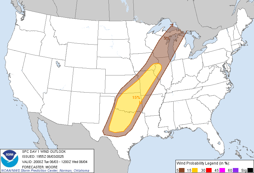 |
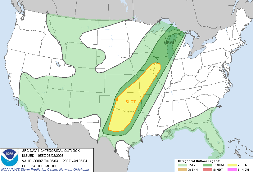
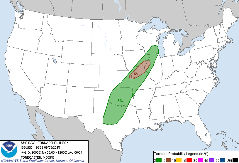
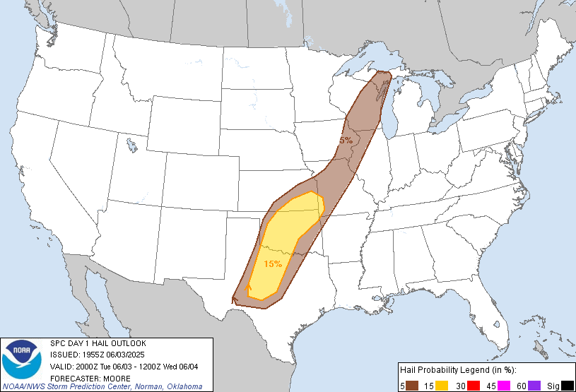
| SPC Day 1 2000z Outlook | Tornado Risk Probabilities | Severe Hail Risk Probabilities | Severe Wind Risk Probabilities |
Watch and Mesoscale Discussion
 |
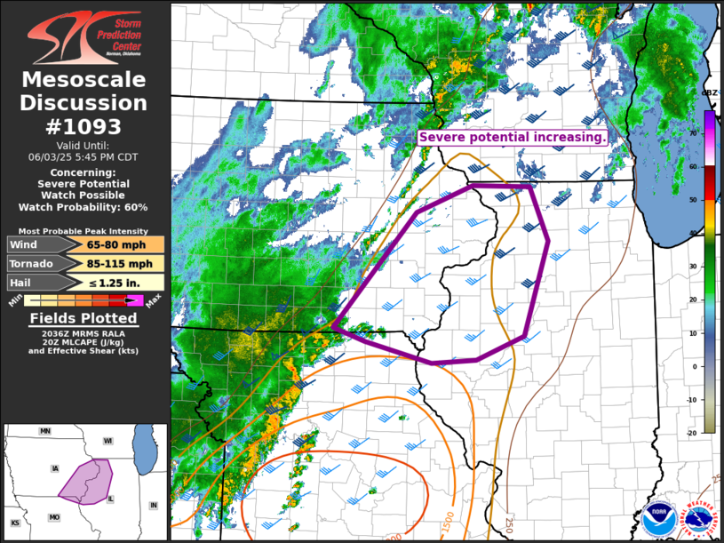 |
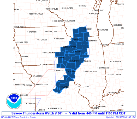
| Tornado Watch #361 | Mesoscale Discussion #1093 |
Davenport, IA Soundings
 |
 |
|
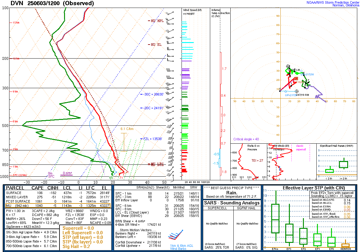
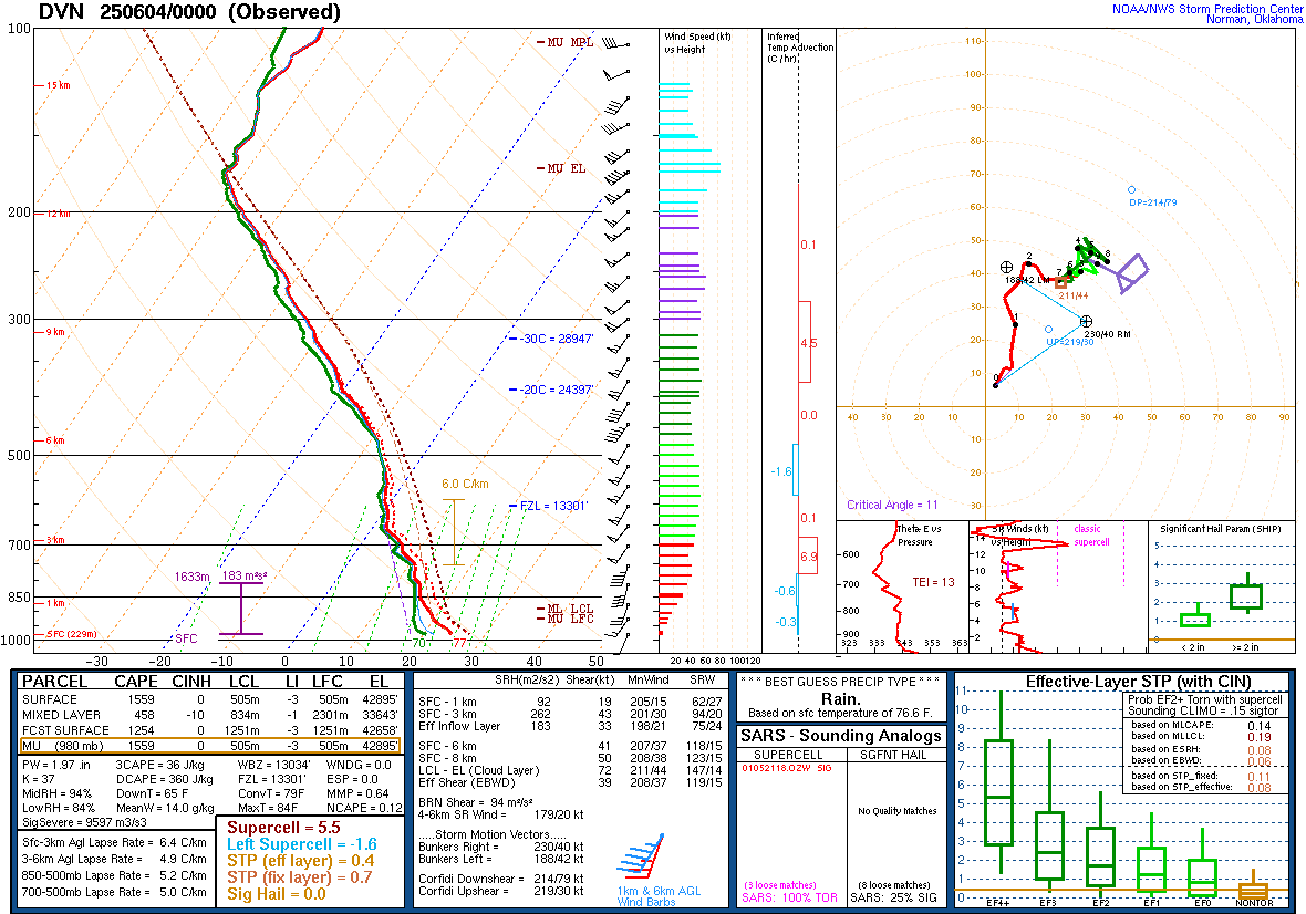
| 06/03/2025 - 7:00 am | 06/03/2025 - 7:00 pm |
Synoptic Environment
 |
 |
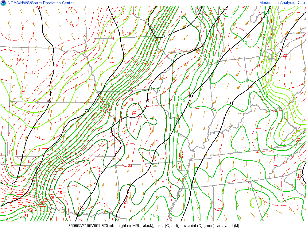 |
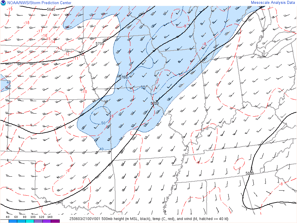
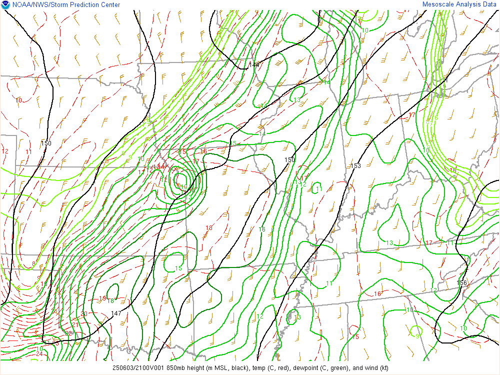
| 500 mb Chart at 4pm | 850 mb Chart at 4pm | 925 mb Chart at 4pm |
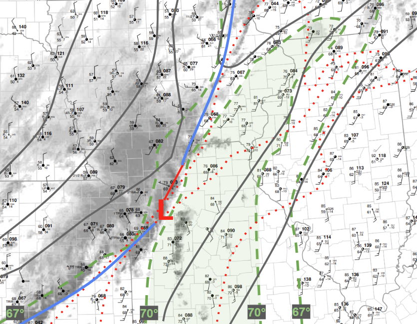 |
| 3 P.M. Surface Analysis |
Mesoscale Environment
 |
 |
 |
.gif) |
|
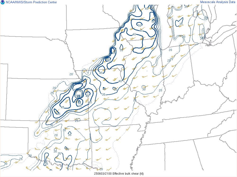
Effective Wind Shear Favorable for Organized Convection |
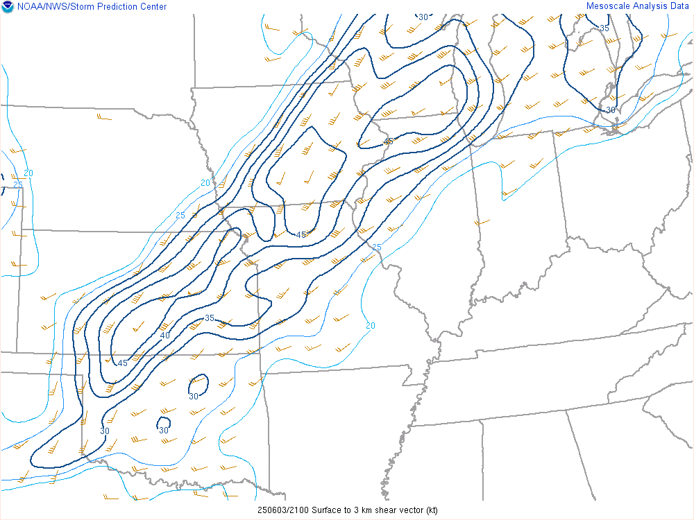
0-3 km Wind Shear Favorable for Mesovortex Development |
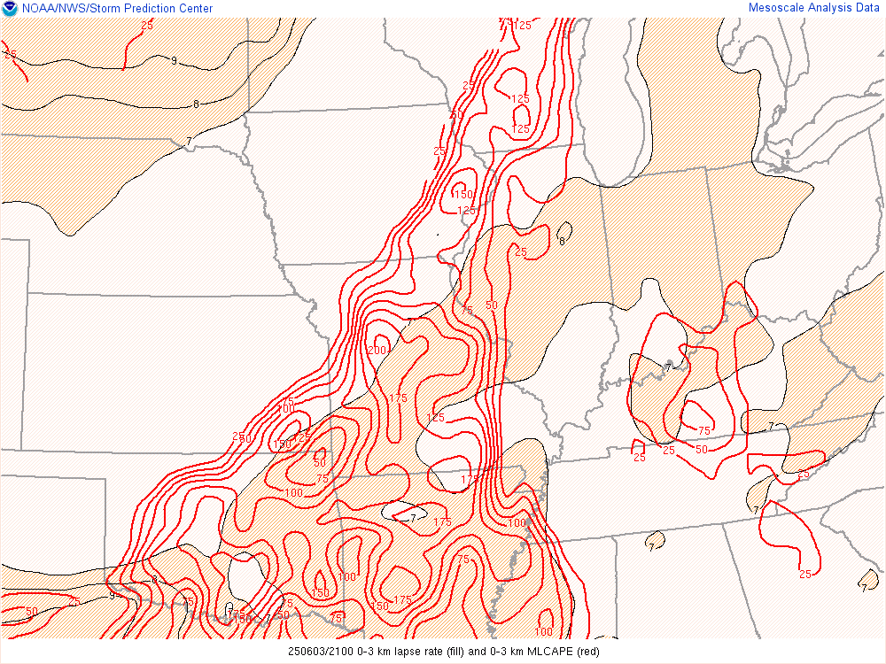
0-3 km CAPE and Lapse Rates Favorable for QLCS Tornadoes |
Mixed Layer CAPE Instability |
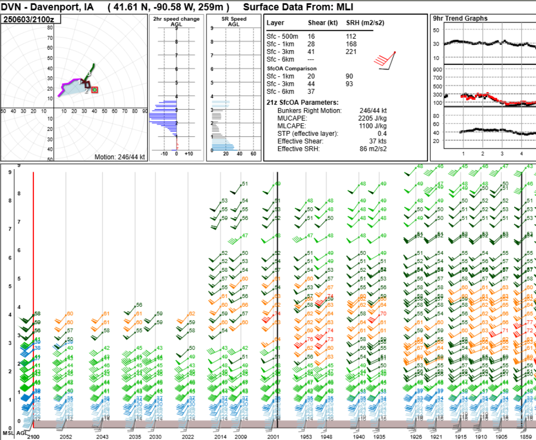 |
| 2-4 P.M. KDVN VAD Wind Profile (from right to left) |
 |
Media use of NWS Web News Stories is encouraged! For more on past weather, please see our Past Events Page. |
|


.png)

.png)