Dangerous heat will expand from the Gulf Coast into the Southern Plains and Desert Southwest through week's end. Additional extreme heat impacting the Pacific Northwest will shift to the northern Plains by the weekend. Tropical Storm Bertha is expected to continue to impact portions of the northern Gulf Coast from the western Florida Panhandle to southeastern Louisiana through tonight. Read More >
Overview
|
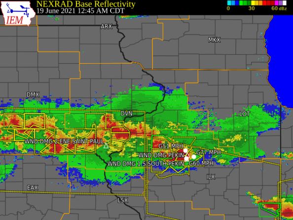
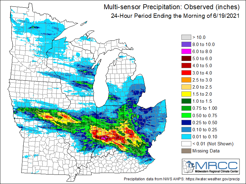
Severe thunderstorms developed across eastern Iowa, northwest Illinois and far northeast Missouri on Friday, June 18, and continued into the early morning hours of Saturday, June 19. The most intense storms produced very large hail and damaging wind gusts. These storms formed along a nearly stationary front that stretched across the southern half of the NWS Quad Cities forecast area. Hail around 1.5 inches in diameter and tree damage were reported, especially in far southeast IA and northwestern IL. Repeat thunderstorms also produced very heavy rainfall, with reports up to 4 inches. Due to the recent dry conditions, no high impact flash flooding was reported.
Surrounding Office Summaries (coming soon) |
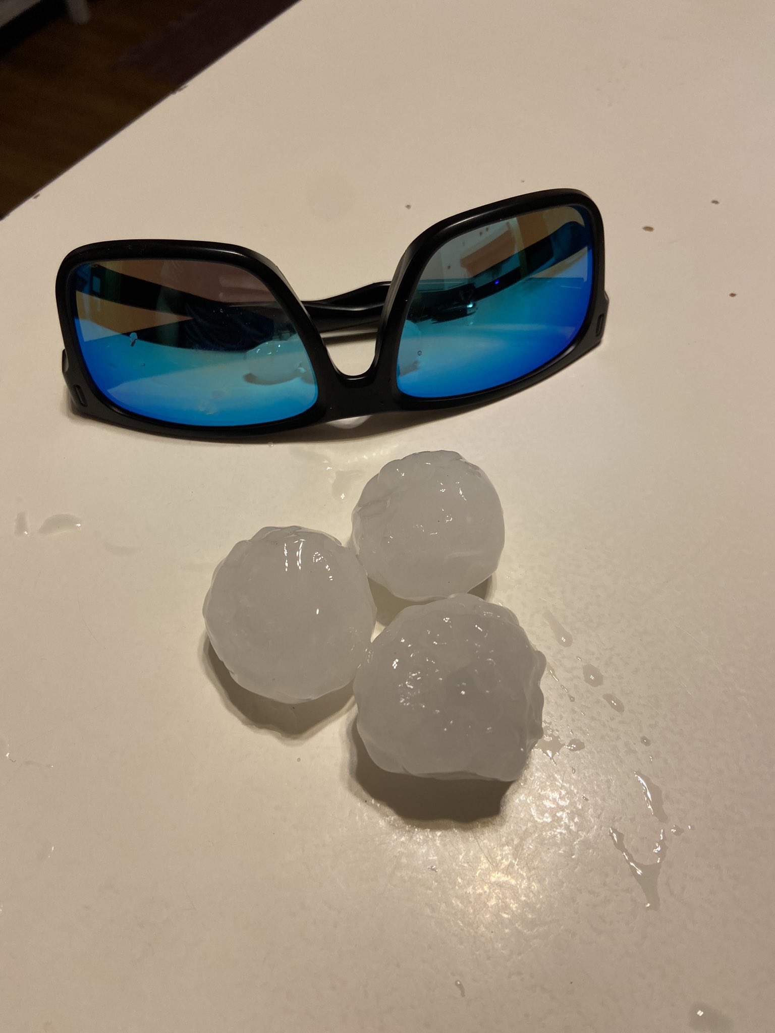
Hail up to Ping-Pong Ball Size that occurred between Keota and Wellman IA. (Courtesy Tyler Romoser) |
Rainfall Reports
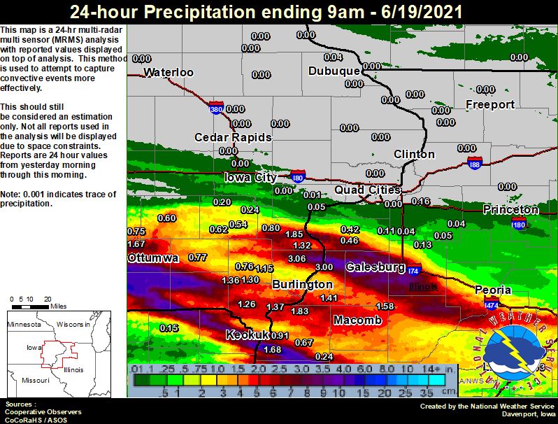
| Local Rainfall Analysis | Regional Rainfall Analysis |
 |
 |
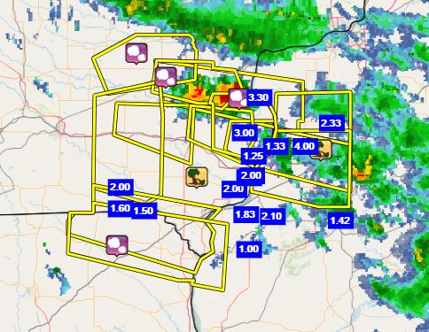
24 hour precipitation reports (in Inches),
for eastern Iowa, northwest and west central Illinois,
and northeast Missouri. Reported between 6 AM and 9 AM,
Saturday June 19, 2021.

....IOWA....
Mediapolis 0.2 WNW               3.06
Burlington 6.5 SSW               2.00
Wapello 0.2 S                    1.85
Ottumwa ASOS 6 NNW               1.67
Rathbun Reservoir 2 N            1.60
Burlington Arpt                  1.48
Burlington 2S                    1.41
Burlington 0.8 SSE               1.41
Fort Madison 0.9 NE              1.37
Salem 1S                         1.36
Wapello 5.4 SE                   1.32
Salem 3.1 ESE                    1.30
Donnellson                       1.26
New London 1.5 SW                1.15
Keokuk LD19                      0.91
Columbus Jct 2 SSW               0.80
Brighton                         0.78
Fairfield                        0.77
Mt Pleasant 1 SSW                0.76
Oskaloosa AWOS 9 ESE             0.75
Pella 4 N                        0.69
Washington 5.8 SW                0.62
Sigourney                        0.60
Washington                       0.54
Centerville 0 NE                 0.43
Ainsworth 7.4 N                  0.24
Beaconsfield 1 NNE               0.23
Wellman 4.0 E                    0.20
Allerton 2 S                     0.13
Rickardsville 0.2 W              0.04
Ames US 30 2 SSE                 0.02
Muscatine 2N                     0.01
Iowa City Arpt                   0.01
NWS Johnston* 5 NNW              0.00
Davenport Arpt                   0.00
Anamosa 3 SSW                    0.00
Maquoketa                        0.00
Manchester                       0.00
Bellevue LD12                    0.00
Mason City ASOS 6 W              0.00
Dubuque LD11                     0.00
Camanche 1.2 W                   0.00
Central City 6.7 W               0.00
Mason City 1 NNE                 0.00
Iowa City                        0.00
Marion 1.7 NNW                   0.00
Elkader 6SSW                     0.00
Cedar Rapids Arpt                0.00
Park View 0.2 WSW                0.00
Boone 1 SSW                      0.00
Pella AWOS 2 WSW                 0.00
Marshalltown 1 NW                0.00
Fayette 1 NW                     0.00
Perry 0 W                        0.00
Charlotte 1.9 WNW                0.00
North Liberty 0.7 SSW            0.00
Toledo 3 N                       0.00
Dubuque Arpt                     0.00
Strawberry Point                 0.00
Hampton 1 N                      0.00
Waterloo ASOS 5 NW               0.00
Guttenberg Dam 10                0.00
Newton 1 NE                      0.00
Grinnell AWOS 2 SSW              0.00
Marshalltown ASOS 4 N            0.00
West Liberty 0.7 NNW             0.00
....ILLINOIS....
Ogden                            3.48
New Boston LD17                  3.30
Oquawka 0.5 N                    3.00
Galesburg                        2.50
Dallas City 3.0 SSE              1.83
Colchester 3.5 NE                1.81
Warsaw 5.8 SE                    1.68
Prairie City 2S                  1.58
Stronghurst 0.4 SSW              1.41
Gladstone LD18                   1.30
Tuscola                          1.30
Lincoln NWS                      1.13
Peoria ASOS                      0.90
Minonk                           0.73
Bloomington Airport              0.73
Bentley                          0.67
Aledo                            0.46
Decatur Airport                  0.46
Windsor                          0.42
Aledo 0.4 NE                     0.42
Jacksonville AWOS                0.36
St Anne                          0.26
Quincy ASOS                      0.25
Augusta                          0.24
Streator 3 SE                    0.21
Geneseo 2.0 NW                   0.16
Altona                           0.13
New Windsor 2.0 N                0.11
Ottawa 4 SW                      0.08
Galva 2.7 NE                     0.05
Ill. City LD16 3 WNW             0.05
Kewanee 1 E                      0.04
Alpha 2.3 N                      0.04
Princeton 1.1 SE                 0.03
Princeton                        0.03
Romeoville                       0.02
Joliet                           0.01
Coleta 1.4 SSW                   0.00
Rockford ASOS                    0.00
Quad City Arpt                   0.00
Mundelein                        0.00
Mount Carroll                    0.00
Rochelle AWOS                    0.00
Moline 2.5 W                     0.00
Paw Paw 1 E                      0.00
Fulton LD13                      0.00
Freeport                         0.00
Steward                          0.00
Freeport 2.0 NW                  0.00
Mount Carroll 6.8 NNW            0.00
Elizabeth                        0.00
Coal Valley 2.6 E                0.00
Walnut 5.3 ENE                   0.00
Freeport 1.7 NW                  0.00
....MISSOURI....
Memphis                          0.15
Kirksville ASOS                  0.04
Chillicothe 2 NW                 0.02
Columbia                         0.00
....WISCONSIN....
Allenton-WWTP .6 NW              0.55
Watertown-AWOS                   0.18
La Crosse WFO                    0.15
Madison-ASOS                     0.04
Beloit-College                   0.00
Delavan-1 W-WWTP 1 W             0.00
Brodhead 1 SW                    0.00
Prairie du Chien AWOS            0.00
Whitewater                       0.00
....MINNESOTA....
Theilman 1SSW                    0.00
Environment
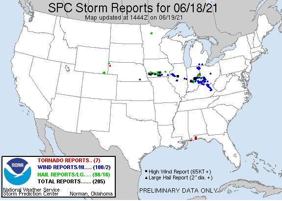
SPC EVENT REVIEW PAGE: 06/18/2021
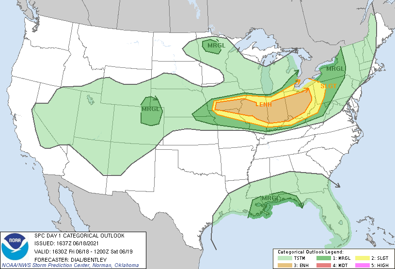
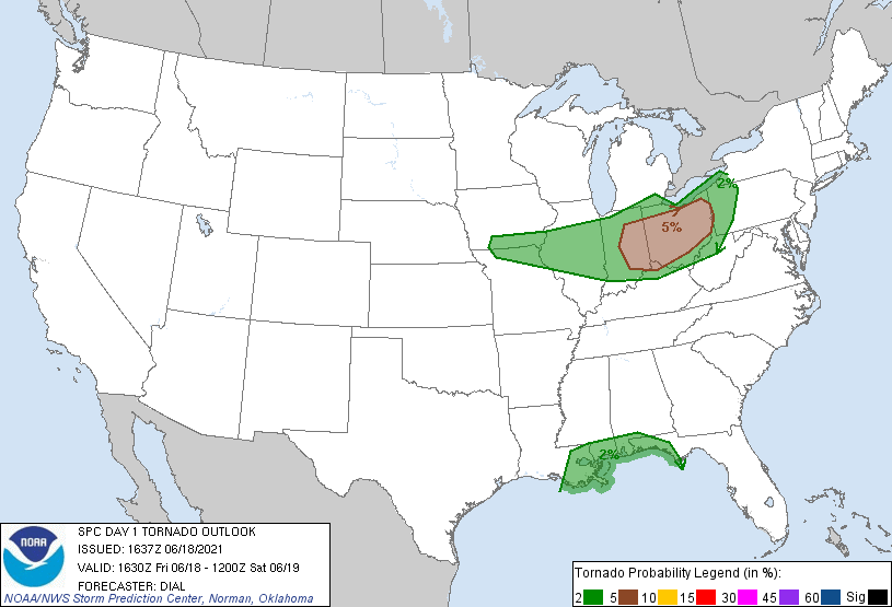
SPC Categorical/Tornado/Hail/Wind Outlooks
 |
 |
 |
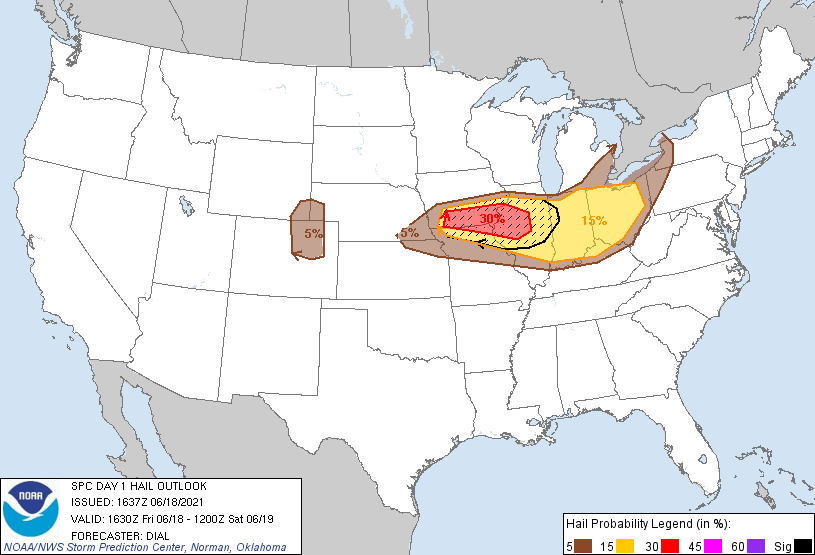 |
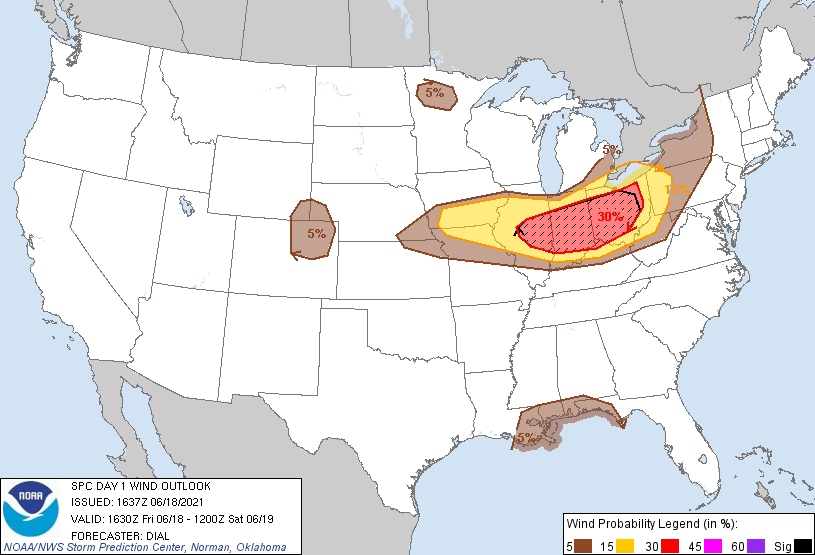
| SPC Categorical Outlook | Tornado Outlook | Wind Outlook | Hail Outlook |
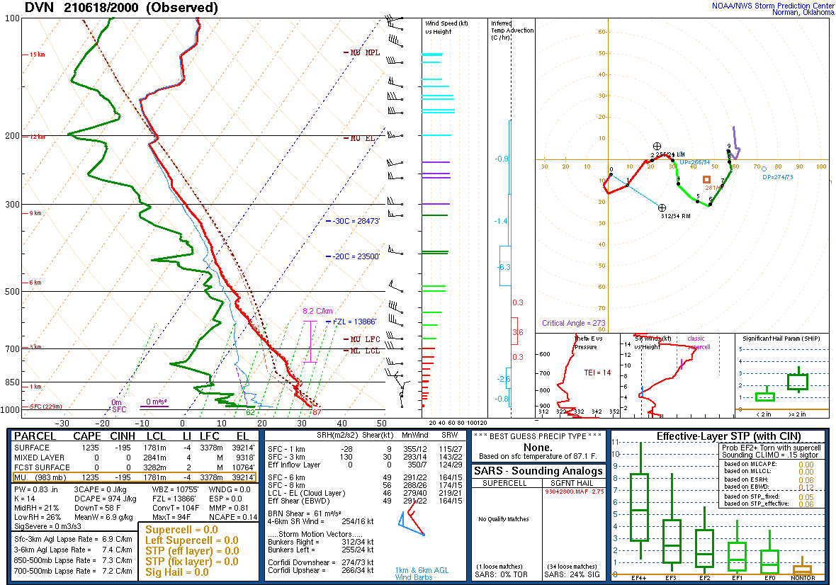
DVN Observed Sounding Analysis
 |
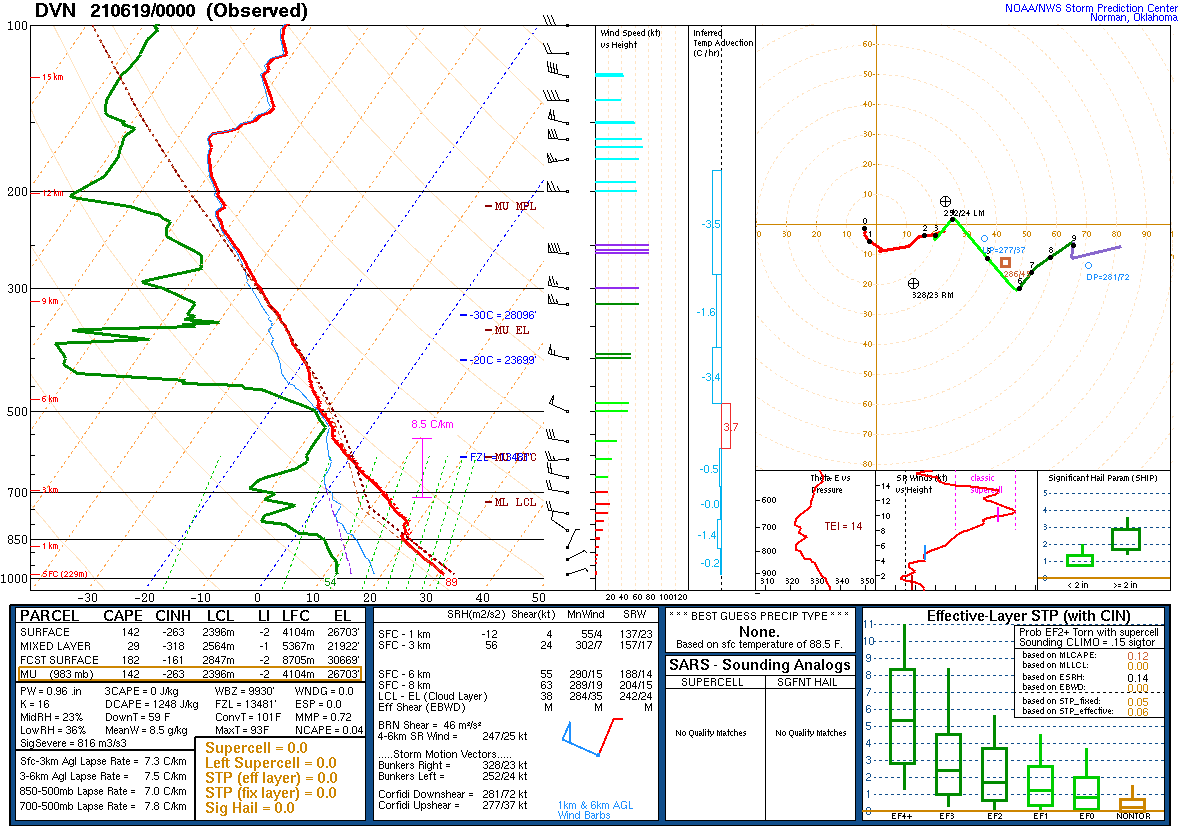 |
| 3 PM DAVENPORT, IA SOUNDING | 7 PM DAVENPORT, IA SOUNDING |
SPC Mesoscale Discussions
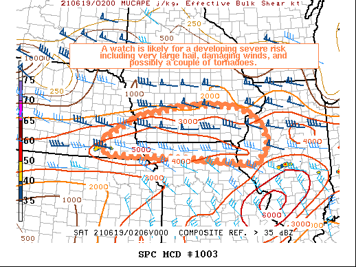 |
| MCD 1003 |
SPC Convective Watches
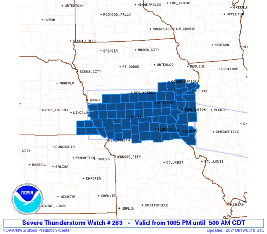 |
| Severe Thunderstorm Watch #359 |
 |
Media use of NWS Web News Stories is encouraged! Please acknowledge the NWS as the source of any news information accessed from this site. |
|