Numerous severe thunderstorms are expected across a broad region from the Ohio Valley to the Mid-Atlantic and Northeast States today into tonight. Swaths of damaging wind gusts are expected and some tornadoes are possible. Bertha is expected to bring tropical storm conditions to portions of the Gulf Coast from the Florida Panhandle westward to southeastern Louisiana later today and Wednesday. Read More >
Overview
|
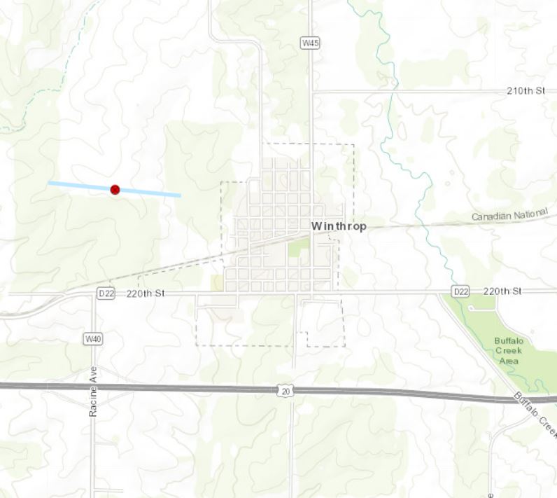
A line of showers and thunderstorms tracked east across Iowa Tuesday afternoon and evening bringing damaging wind, occasional lightning, and heavy rain to eastern IA and northwest IL. The strongest reported winds of 60-70 mph, occurred in Buchanan and Linn counties. These winds brought down trees and powerlines as they moved through in the evening. In addition, heavy rain occurred with the highest amounts over 1 inch common in Jo Daviess and Stephenson counties in IL. A brief tornado occurred just west of Winthrop IA in an open field. Since no visible damage was seen, an EF-U rating was assigned to the tornado. The NWS would like to thank Buchanan County Emergency Management for assistance with this storm.
|
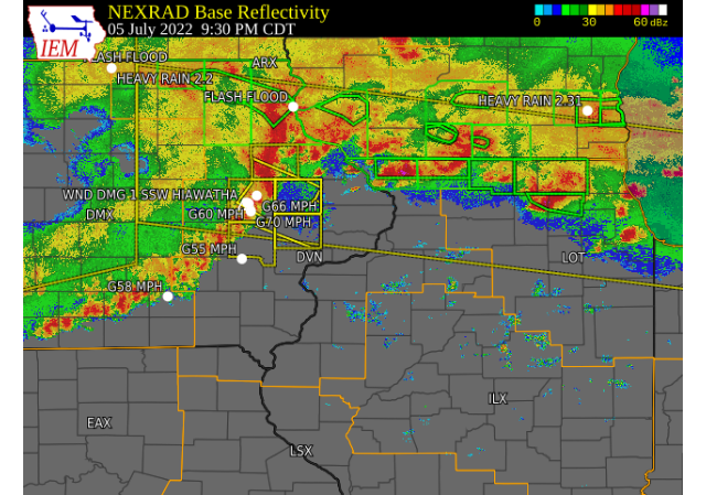 Radar Image : Courtesy Iowa Environment Mesonet Interactive Loop Link |
Tornado
|
1.0 NW Winthrop, IA
|
||||||||||||||||
|
|
||||||||||||||||
Storm Reports
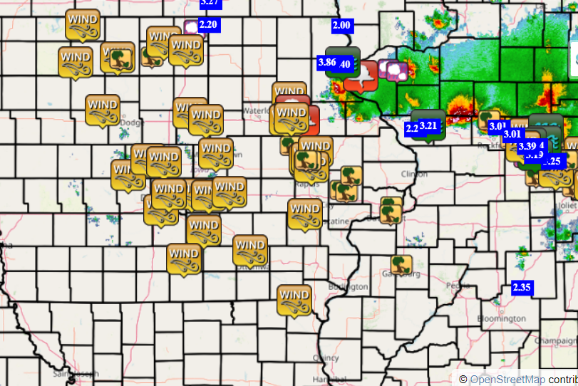
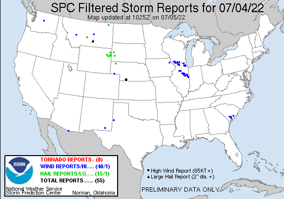
| Interactive Storm Report Map (IEM) | SPC Storm Reports |
 |
 |
PRELIMINARY LOCAL STORM REPORT...SUMMARY
NATIONAL WEATHER SERVICE QUAD CITIES IA IL
929 AM CDT WED JUL 6 2022

..TIME...   ...EVENT...      ...CITY LOCATION...     ...LAT.LON...
..DATE...   ....MAG....      ..COUNTY LOCATION..ST.. ...SOURCE....
            ..REMARKS..

0835 PM     TSTM WND DMG     INDEPENDENCE            42.47N 91.89W
07/05/2022                   BUCHANAN           IA   EMERGENCY MNGR

            EMERGENCY MANAGER REPORTED TREES AND
            POWERLINES DOWN ACROSS THE COUNTY. WIND
            CONTINUED FOR SEVERAL MINUTES. LEADING EDGE
            OF STORM APPROXIMATELY MOVED THROUGH BETWEEN
            835 AND 911 PM.

0847 PM     FUNNEL CLOUD     5 SSE HAZLETON          42.55N 91.86W
07/05/2022                   BUCHANAN           IA   TRAINED SPOTTER

            OBSERVED BY SPOTTER BETWEEN INDEPENDENCE AND
            QUASQUETON LOOKING WEST ABOUT 3 TO 4 MILES.

0850 PM     FUNNEL CLOUD     2 S WINTHROP            42.44N 91.73W
07/05/2022                   BUCHANAN           IA   TRAINED SPOTTER

            OBSERVED SOUTHWEST OF THIS LOCATION POSSIBLY
            NEAR ROWLEY.

0851 PM     TSTM WND GST     1 WNW INDEPENDENCE      42.47N 91.91W
07/05/2022  E70 MPH          BUCHANAN           IA   TRAINED SPOTTER

            ESTIMATED GUSTS OF 60-70.

0855 PM     TSTM WND DMG     1 WNW INDEPENDENCE      42.47N 91.91W
07/05/2022                   BUCHANAN           IA   PUBLIC

            6 TO 8 INCH TREE BRANCH DOWN.

0855 PM     TSTM WND GST     INDEPENDENCE AIRPORT    42.45N 91.95W
07/05/2022  M52 MPH          BUCHANAN           IA   AWOS

            MEASURED GUST OF 52 MPH.

0900 PM     TSTM WND DMG     2 SSW URBANA            42.19N 91.89W
07/05/2022                   BENTON             IA   PARK/FOREST SRVC

            TREES DOWN AT WILDCAT BLUFF STATE PARK.
            RELAYED BY EMERGENCY MANAGER.. MAY HAVE BEEN
            CAUSED BY THUNDERSTORM OUTFLOW WINDS.
            RELAYED BY EMERGENCY MANAGEMENT.

0904 PM     TSTM WND GST     1 ESE INDEPENDENCE      42.47N 91.88W
07/05/2022  M60 MPH          BUCHANAN           IA   TRAINED SPOTTER


0905 PM     TSTM WND GST     2 SSE HIAWATHA          42.02N 91.66W
07/05/2022  E60 MPH          LINN               IA   TRAINED SPOTTER

            WIND GUSTS BEGAN AROUND 905 AND LASTED ABOUT
            10 TO 15 MINUTES.

0907 PM     TSTM WND GST     1 SE HIAWATHA           42.04N 91.67W
07/05/2022  E70 MPH          LINN               IA   PUBLIC

            ESTIMATED WINDS WITH GUST FRONT. BRIEF POWER
            OUTAGE. WINDS UNDER 50 MPH NOW. FORMER
            SPOTTER.

0907 PM     TSTM WND DMG     3 SW ROWLEY             42.33N 91.89W
07/05/2022                   BUCHANAN           IA   PUBLIC

            REPORT FROM MPING: 3-INCH TREE LIMBS BROKEN;
            POWER POLES BROKEN.

0910 PM     TSTM WND DMG     1 NNE CEDAR RAPIDS      41.98N 91.66W
07/05/2022                   LINN               IA   BROADCAST MEDIA

            DAMAGE TO EXTERIOR BUILDING SIGNAGE AT KCRG
            TV STUDIOS. TIME ESTIMATED FROM RADAR.

0911 PM     TSTM WND GST     HIAWATHA                42.05N 91.68W
07/05/2022  E70 MPH          LINN               IA   TRAINED SPOTTER

            OUTFLOW WINDS KNOCKED OUT POWER.

0914 PM     TSTM WND DMG     2 SSE HIAWATHA          42.02N 91.66W
07/05/2022                   LINN               IA   TRAINED SPOTTER

            LARGE LIMBS DOWN.

0915 PM     TSTM WND DMG     1 SSW HIAWATHA          42.04N 91.69W
07/05/2022                   LINN               IA   PUBLIC

            TREE DOWN.

0916 PM     TSTM WND GST     2 WNW MARION            42.05N 91.63W
07/05/2022  E60 MPH          LINN               IA   TRAINED SPOTTER

            ESTIMATED THUNDERSTORM WIND GUST OF 60 MPH.

0918 PM     TSTM WND GST     ATKINS                  42.00N 91.87W
07/05/2022  M62 MPH          BENTON             IA   PUBLIC


0920 PM     TSTM WND GST     4 ESE ALBURNETT         42.13N 91.55W
07/05/2022  M66 MPH          LINN               IA   PUBLIC


0920 PM     TSTM WND GST     2 ENE HIAWATHA          42.06N 91.65W
07/05/2022  E65 MPH          LINN               IA   TRAINED SPOTTER

            POWER OUTAGE TOO.

0920 PM     TSTM WND GST     3 E CEDAR RAPIDS        41.97N 91.61W
07/05/2022  E70 MPH          LINN               IA   TRAINED SPOTTER

            REPORTED A 70 MPH WIND GUST BUT NO DAMAGE
            WAS REPORTED.

0921 PM     TSTM WND DMG     HIAWATHA                42.05N 91.68W
07/05/2022                   LINN               IA   TRAINED SPOTTER

            POWER LINES DOWN. WINDS ESTIMATED TO BE
            SUSTAINED AT 55 MPH.

0921 PM     TSTM WND DMG     2 WNW MARION            42.04N 91.62W
07/05/2022                   LINN               IA   PUBLIC

            3-INCH TREE LIMBS BROKEN; POWER POLES
            BROKEN.

0936 PM     TSTM WND GST     KALONA                  41.49N 91.70W
07/05/2022  E55 MPH          WASHINGTON         IA   TRAINED SPOTTER

            HEAVY BRANCH DOWN. TIME ESTIMATED.

0940 PM     TSTM WND DMG     HOPKINTON               42.35N 91.25W
07/05/2022                   DELAWARE           IA   TRAINED SPOTTER

            REPORTED A TREE DOWN ON POWERLINES.

0958 PM     TSTM WND DMG     2 E CEDAR VALLEY        41.74N 91.20W
07/05/2022                   CEDAR              IA   LAW ENFORCEMENT

            LAW ENFORCEMENT REPORTS TREES DOWN.

1000 PM     FLASH FLOOD      3 N STOCKTON            42.40N 90.00W
07/05/2022                   JO DAVIESS         IL   CO-OP OBSERVER

            PATIO FLOODED WITH WATER INTO BASEMENT
            WINDOW. 3.05 INCHES BETWEEN 9 AND 11 PM.

1000 PM     TSTM WND DMG     CLARENCE                41.89N 91.06W
07/05/2022                   CEDAR              IA   EMERGENCY MNGR

            POWER LINES DOWN. TIME ESTIMATED.

1000 PM     TSTM WND DMG     3 S TIPTON              41.72N 91.13W
07/05/2022                   CEDAR              IA   EMERGENCY MNGR

            POWER LINES DOWN SOUTH OF TIPTON. TIME
            ESTIMATED.

1025 PM     TSTM WND DMG     1 S SALEM               40.83N 91.62W
07/05/2022                   HENRY              IA   CO-OP OBSERVER

            CORRECTS PREVIOUS TSTM WND DMG REPORT FROM 1
            S SALEM. DELAYED REPORT. SEVERAL TREE
            BRANCHES DOWN ON PROPERTY. TIME ESTIMATED
            FROM RADAR.

1038 PM     TSTM WND DMG     4 SW DERINDA CENTER     42.21N 90.23W
07/05/2022                   JO DAVIESS         IL   LAW ENFORCEMENT

            REPORT OF TREE DOWN ON RUSH STREET SOUTH OF
            HANOVER IL, RELAYED BY LAW ENFORCEMENT. TIME
            ESTIMATED BY RADAR.

1040 PM     TSTM WND GST     3 ENE CHARLIE HEATH MEM 40.59N 91.84W
07/05/2022  E55 MPH          CLARK              MO   TRAINED SPOTTER


1040 PM     TSTM WND DMG     2 W BETTENDORF          41.57N 90.51W
07/05/2022                   SCOTT              IA   NWS EMPLOYEE

            8-10 INCH DIAMETER TREE LIMB DOWN. TIME
            ESTIMATED FROM RADAR.

1040 PM     TSTM WND DMG     1 NNE FORT MADISON      40.63N 91.35W
07/05/2022                   LEE                IA   PUBLIC

            4-6 DIAMETER TREE BRANCH SNAPPED. REPORT
            RELAYED BY SOCIAL MEDIA. TIME ESTIMATED FROM
            RADAR.

1042 PM     TSTM WND DMG     3 ESE NEW BOSTON        41.15N 90.95W
07/05/2022                   MERCER             IL   LAW ENFORCEMENT

            REPORT OF TREE DOWN ALONG 76TH STREET. TIME
            ESTIMATED BY RADAR.

1055 PM     HEAVY RAIN       2 NW WOODBINE           42.37N 90.19W
07/05/2022  M2.25 INCH       JO DAVIESS         IL   TRAINED SPOTTER


1057 PM     TSTM WND DMG     GREEN ROCK              41.47N 90.36W
07/05/2022                   HENRY              IL   PUBLIC

            LARGE TREE DOWN, REPORT RELAYED FROM SOCIAL
            MEDIA. TIME ESTIMATED FROM RADAR.

1101 PM     TSTM WND DMG     1 N FRUITLAND           41.49N 90.52W
07/05/2022                   ROCK ISLAND        IL   PUBLIC

            1-INCH TREE LIMBS BROKEN; SHINGLES BLOWN
            OFF.

1130 PM     HEAVY RAIN       3 N STOCKTON            42.40N 90.00W
07/05/2022  M3.21 INCH       JO DAVIESS         IL   CO-OP OBSERVER

            RAINFALL TOTAL SINCE ABOUT 9 PM.

0507 AM     HEAVY RAIN       3 NNE BOLTON            42.29N 89.72W
07/06/2022  M1.54 INCH       STEPHENSON         IL   COCORAHS

            COCORAHS STATION IL-SP-28 FREEPORT 4.3 W.

0653 AM     HEAVY RAIN       2 NW FREEPORT           42.30N 89.66W
07/06/2022  M1.95 INCH       STEPHENSON         IL   COCORAHS

            COCORAHS STATION IL-SP-25 FREEPORT 1.7 NW.

0659 AM     HEAVY RAIN       2 SW YARMOUTH           41.01N 91.35W
07/06/2022  M1.17 INCH       DES MOINES         IA   TRAINED SPOTTER


0700 AM     HEAVY RAIN       1 E FREEPORT            42.29N 89.61W
07/06/2022  M1.30 INCH       STEPHENSON         IL   COCORAHS

            COCORAHS STATION IL-SP-29 1 E FREEPORT.

0700 AM     HEAVY RAIN       3 NNE MC CONNELL        42.47N 89.72W
07/06/2022  M3.53 INCH       STEPHENSON         IL   COCORAHS

            COCORAHS STATION IL-SP-8 WINSLOW 4.3 ESE.

0700 AM     HEAVY RAIN       6 SSE ELMOVILLE         42.19N 90.02W
07/06/2022  M1.29 INCH       CARROLL            IL   COCORAHS

            COCORAHS STATION IL-CR-12 MOUNT CARROLL 6.8
            NNW.

0730 AM     HEAVY RAIN       DAVIS                   42.43N 89.42W
07/06/2022  M1.99 INCH       STEPHENSON         IL   COCORAHS

            COCORAHS STATION IL-SP-7 DAVIS 0.5 N.

0746 AM     HEAVY RAIN       3 N STOCKTON            42.40N 90.00W
07/06/2022  M3.36 INCH       JO DAVIESS         IL   CO-OP OBSERVER

            STORM TOTAL, 24-HR.

0830 AM     HEAVY RAIN       2 WSW LORAN             42.22N 89.95W
07/06/2022  M1.70 INCH       JO DAVIESS         IL   MESONET

            MESONET STATION FW6589 MOUNT CARROLL.

0845 AM     HEAVY RAIN       RICKARDSVILLE           42.58N 90.88W
07/06/2022  E1.30 INCH       DUBUQUE            IA   TRAINED SPOTTER

            STORM TOTAL.
Rain Reports
| Local 24-hr Rainfall | Regional 24-hr Rainfall |
.png) |
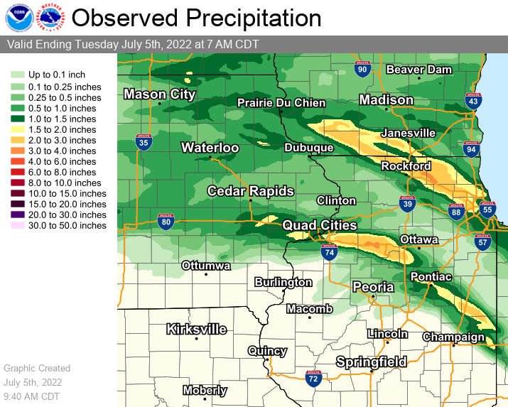 |
24 hour precipitation reports (in Inches),
for eastern Iowa, northwest and west central Illinois,
and northeast Missouri. Reported between Midnight and 9 AM,
Wednesday July 06, 2022.

....IOWA....
Elkader 6SSW                     2.29
Guttenberg Dam 10                1.71
Mason City 1 NNE                 1.41
Strawberry Point                 1.41
Bellevue LD12                    1.22
Camanche 1.2 W                   1.09
Morning Sun 1.7 E                1.07
Dubuque #3 7 SW                  1.04
Dubuque Arpt                     1.01
Wapello 5.4 SE                   0.96
Dubuque LD11                     0.96
Fort Madison 0.9 NE              0.90
Oelwein AWOS                     0.89
Burlington 6.5 SSW               0.85
Peosta 2.9 E                     0.84
Manchester                       0.83
Keokuk LD19                      0.74
Waterloo ASOS 5 NW               0.73
New London 1.5 SW                0.71
Fayette 1 NW                     0.70
Mason City ASOS 6 W              0.68
Oelwein 1E                       0.68
Waukon 3N                        0.66
Maquoketa                        0.64
Hampton 1 N                      0.63
Monticello 1 E                   0.63
Cascade                          0.59
Charlotte 1.9 WNW                0.58
Asbury 0.4 SW                    0.57
Pella AWOS 2 WSW                 0.52
NWS Johnston* 5 NNW              0.51
Centerville 0 NE                 0.47
Pella 4 N                        0.46
Rathbun Reservoir 2 N            0.45
Burlington Arpt                  0.44
Tipton 0.7 N                     0.43
Burlington 2S                    0.42
Salem 1S                         0.42
Solon 0.3 ESE                    0.41
Salem 3.1 ESE                    0.38
Anamosa 3 SSW                    0.37
Oskaloosa 1 NNW                  0.35
Ottumwa ASOS 6 NNW               0.35
Muscatine 2N                     0.33
Park View 0.2 WSW                0.31
Mt Pleasant 1 SSW                0.31
Iowa City Arpt                   0.28
North Liberty 0.7 SSW            0.27
Williamsburg                     0.27
Wellman 4.0 E                    0.25
Sigourney                        0.25
Belle Plaine                     0.25
West Point 7.5 NW                0.23
West Liberty 0.7 NNW             0.23
Ames US 30 2 SSE                 0.23
Fairfax 4.0 NW                   0.22
Mount Auburn 2.2 NNW             0.21
Marshalltown ASOS 4 N            0.21
Boone 1 SSW                      0.21
Swisher 0.4 NNE                  0.20
Cedar Rapids Arpt                0.20
Newton 1 NE                      0.20
Swisher                          0.20
Wapello 0.2 S                    0.19
Muscatine 2.6 NNE                0.19
De Witt                          0.19
Parnell 0.1 SSW                  0.18
Grinnell 2 SW                    0.18
Riverdale 0.5 N                  0.17
Marengo 3.6 N                    0.17
Grinnell AWOS 2 SSW              0.17
Perry 0 W                        0.16
Marion 1.7 NNW                   0.15
Iowa City                        0.15
Muscatine 1.4 N                  0.13
Davenport Arpt                   0.13
Marshalltown 1 NW                0.13
Washington 5.8 SW                0.12
Central City 6.7 W               0.12
Marengo 2.6 SSW                  0.11
Fairfield                        0.10
Marengo                          0.10
Washington                       0.09
Ainsworth 7.4 N                  0.08
Davenport 0.9 WNW                0.07
Calamus 2.0 NE                   0.05
Wapello 4.7 N                    0.03
Columbus Jct 2 SSW               0.03
Nichols 3.2 SSW                  0.00
Oskaloosa AWOS 9 ESE             0.00
....ILLINOIS....
Winslow 4.3 ESE                  3.53
Stockton 3.4 NNE                 3.43
Davis 0.5 N                      1.99
Freeport 1.7 NW                  1.95
Rockford Arpt                    1.51
Freeport                         1.50
Mount Carroll 6.8 NNW            1.20
Ridott 0.1 NE                    1.08
Elizabeth                        1.05
Freeport 2.9 WSW                 1.00
Lanark 6.0 E                     0.97
Morrison 3.2 E                   0.85
Hanover 0.2 NW                   0.83
New Boston LD17                  0.78
Stronghurst 0.4 SSW              0.75
Mount Carroll                    0.69
Gladstone LD18                   0.66
Steward                          0.63
Lanark 5.3 N                     0.62
Aledo                            0.58
Alpha 2.3 N                      0.56
New Windsor 2.0 N                0.55
Quincy Arpt                      0.49
Walnut 5.3 ENE                   0.47
Woodhull 0.3 ESE                 0.46
Prophetstown 0.2 SW              0.42
Augusta                          0.42
Mundelein                        0.41
Paw Paw 1 E                      0.39
Moline 0.7 NNE                   0.33
Romeoville                       0.27
Galva 2.7 NE                     0.26
Bentley                          0.25
Warsaw 5.8 SE                    0.24
Dallas City 3.0 SSE              0.23
Ottawa 4 SW                      0.23
Galesburg                        0.22
Colchester 3.5 NE                0.20
Mendota 2 SE                     0.17
Jacksonville Arpt                0.15
Princeton 1.1 SE                 0.14
Princeton                        0.14
Peoria Arpt                      0.14
Jacksonville 2E                  0.13
Joliet Arpt                      0.13
Geneseo 2.0 NW                   0.11
Kewanee 1 E                      0.10
Prairie City 2S                  0.08
Coal Valley 1.9 SE               0.07
Ill. City LD16 3 WNW             0.07
Streator 3 SE                    0.02
Quad City Arpt                   0.02
St Anne                          0.00
Bloomington Airport              0.00
Lincoln NWS                      0.00
Moline 2.5 W                     0.00
Tuscola                          0.00
Decatur Airport                  0.00
Rochelle Arpt                    0.00
Windsor                          0.00
Ogden                            0.00
....MISSOURI....
Chillicothe Arpt                 0.56
Kahoka 0.6 S                     0.53
Memphis 0.1 S                    0.40
Memphis                          0.29
Kirksville Arpt                  0.21
Columbia Arpt                    0.04
....WISCONSIN....
Brodhead 1 SW                    3.61
Monroe 1 W                       2.73
Prairie du Chien AWOS            2.10
Madison Arpt                     1.92
Sullivan-NWS 2 SE                1.92
Darlington                       1.79
Viroqua                          1.15
Steuben 4SE 3 NE                 1.09
Whitewater                       0.74
La Crosse WFO                    0.38
Environment
 |
 |
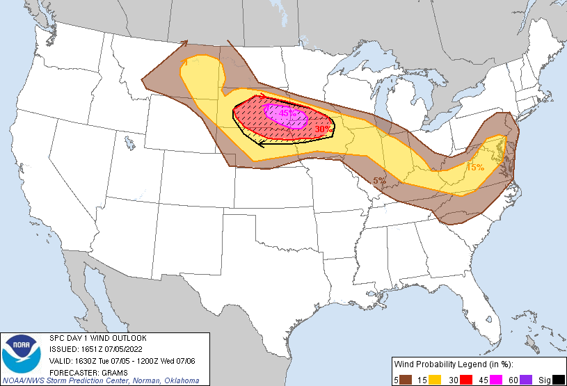 |
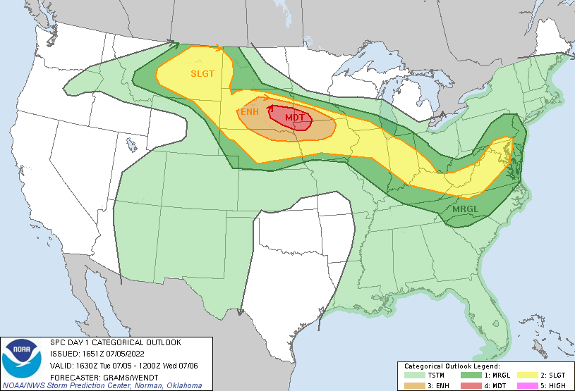
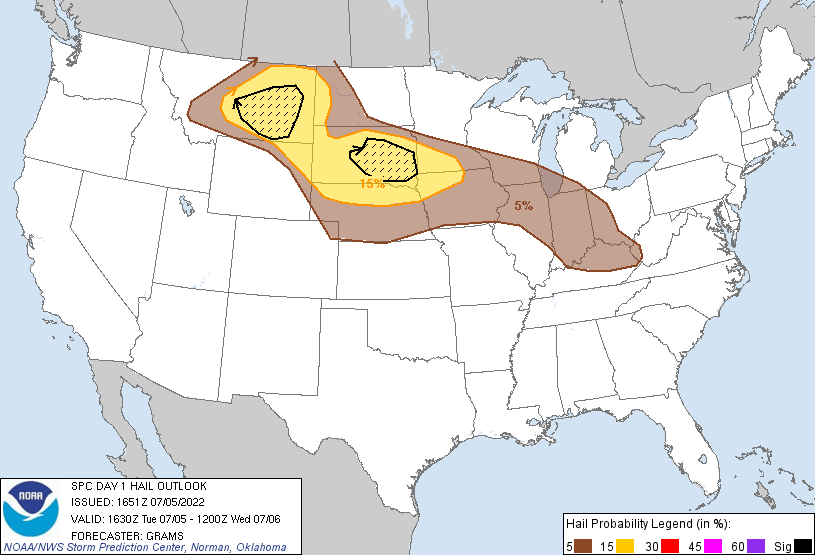
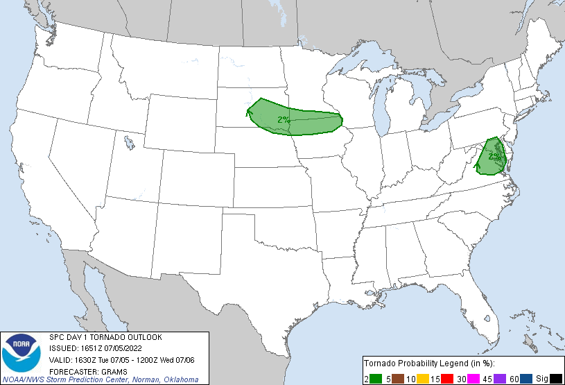
| Figure 1: SPC Day 1 Outlook 1630z | Figure 2: SPC Day 1 Hail Outlook 1630z | Figure 3: SPC Day 1 Wind Outlook 1630z |
 |
 |
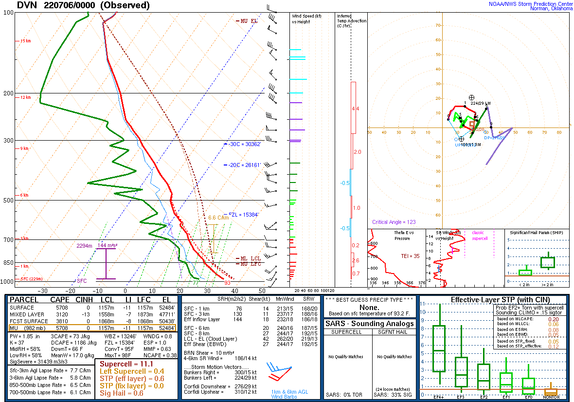 |
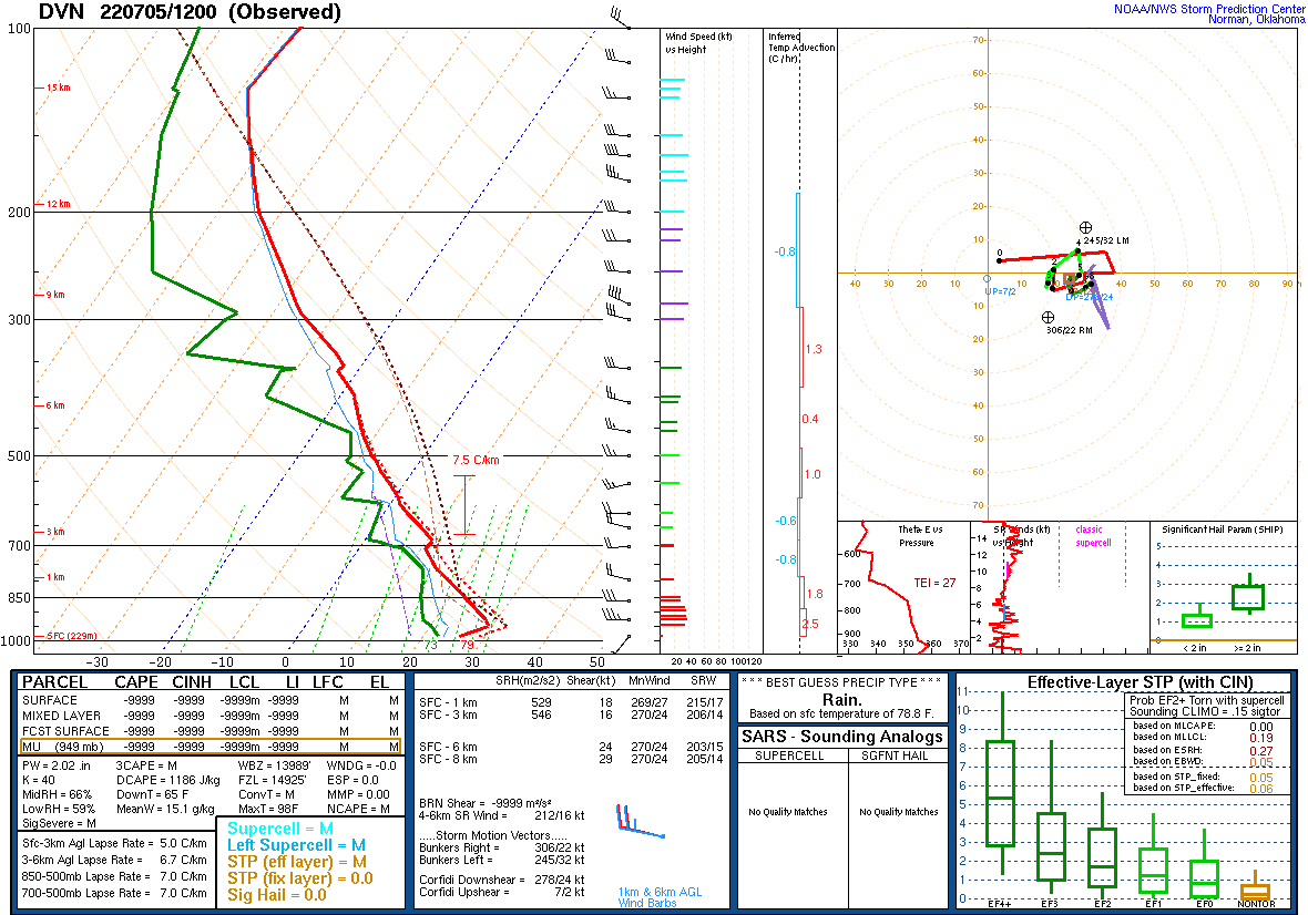
| Figure 4: SPC Day 1 Tornado Outlook 1630z | Figure 5: DVN 12z Sounding | Figure 6: DVN 00z Sounding |
 |
Media use of NWS Web News Stories is encouraged! Please acknowledge the NWS as the source of any news information accessed from this site. |
|