Overview
|
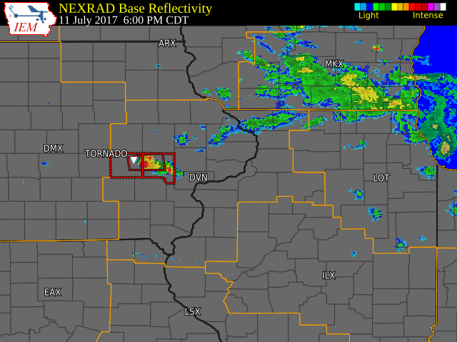
Several rounds of thunderstorms moved across northern Dubuque and Jo Daviess Counties late last night into very early this morning. The intial thunderstorm produced widespread damaging winds across northern Dubuque County. In addition to the damaging winds, successive thunderstorms produced very heavy rainfall of 2 to 5 inches over a 2 to 3 hour period. This lead to flash flooding across this area early this morning. Earlier in the evening, a supercell thunderstorm rapidly developed and produced a tornado near Conroy, IA in Iowa county Tuesday evening. This storm also produced torrential rain, large hail, and numerous lightning strikes as it slowly tracked east. |
Tornadoes:
|
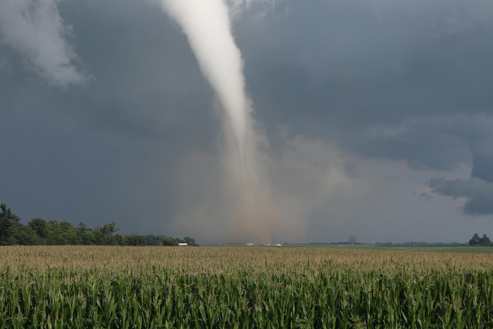
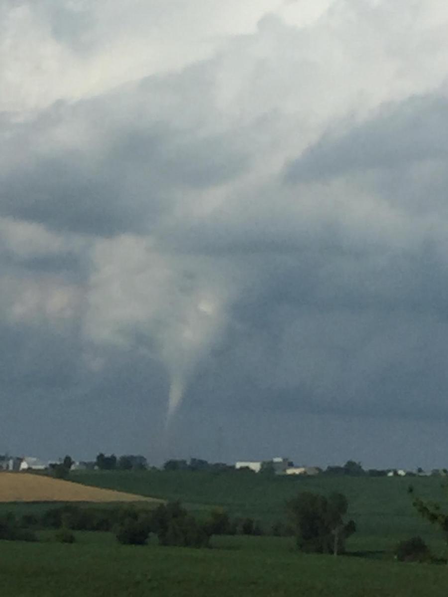
Tornado - Conroy, IA
Track Map 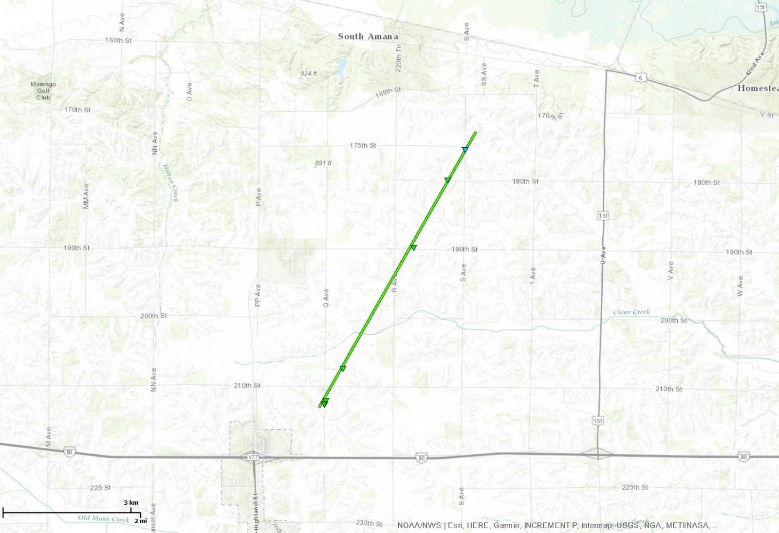 
|
||||||||||||||||
|
||||||||||||||||
The Enhanced Fujita (EF) Scale classifies tornadoes into the following categories:
| EF0 Weak 65-85 mph |
EF1 Moderate 86-110 mph |
EF2 Significant 111-135 mph |
EF3 Severe 136-165 mph |
EF4 Extreme 166-200 mph |
EF5 Catastrophic 200+ mph |
 |
|||||
Storm Reports
| Interactive Storm Report Map | SPC Storm Reports |
 |
 |
319
NWUS53 KDVN 121358
LSRDVN
PRELIMINARY LOCAL STORM REPORT...SUMMARY
NATIONAL WEATHER SERVICE QUAD CITIES IA IL
858 AM CDT WED JUL 12 2017
..TIME... ...EVENT... ...CITY LOCATION... ...LAT.LON...
..DATE... ....MAG.... ..COUNTY LOCATION..ST.. ...SOURCE....
..REMARKS..
0546 PM FUNNEL CLOUD E CONROY 41.73N 92.00W
07/11/2017 IOWA IA LAW ENFORCEMENT
0549 PM FUNNEL CLOUD 10 SW CEDAR RAPIDS MUNI 41.78N 91.85W
07/11/2017 IOWA IA OTHER FEDERAL
CID TOWER REPORTING FUNNEL CLOUD ESTIMATED 10 MILES
SOUTHWEST OF THE FIELD MOVING TO THE EAST NORTHEAST.
0552 PM TORNADO 3 NE CONROY 41.76N 91.96W
07/11/2017 IOWA IA LAW ENFORCEMENT
TROOPER WAS FLYING IN AIRPLANE WITH VISUAL.
0715 PM HAIL N IOWA CITY 41.66N 91.54W
07/11/2017 M0.50 INCH JOHNSON IA EMERGENCY MNGR
REPORT FROM INTERSTATE 80
0725 PM HAIL E IOWA CITY 41.66N 91.54W
07/11/2017 E0.75 INCH JOHNSON IA EMERGENCY MNGR
PEA TO DIME HAIL EAST SIDE OF IOWA CITY 7TH AND MUSCATINE
AVE.
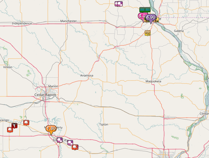
0733 PM HEAVY RAIN 1 SW NORTH LIBERTY 41.73N 91.62W
07/11/2017 M1.80 INCH JOHNSON IA TRAINED SPOTTER
RAIN FELL IN PAST 1 HOUR.
0748 PM HAIL 2 WSW DOWNEY 41.61N 91.39W
07/11/2017 M0.50 INCH JOHNSON IA EMERGENCY MNGR
0750 PM HAIL 3 W DOWNEY 41.61N 91.40W
07/11/2017 M1.50 INCH JOHNSON IA EMERGENCY MNGR
0756 PM FUNNEL CLOUD 3 W DOWNEY 41.61N 91.40W
07/11/2017 JOHNSON IA NWS EMPLOYEE
0757 PM HAIL 5 ESE IOWA CITY 41.64N 91.44W
07/11/2017 M0.50 INCH JOHNSON IA TRAINED SPOTTER
1048 PM HAIL NW HOLY CROSS 42.60N 91.00W
07/11/2017 M1.00 INCH DUBUQUE IA EMERGENCY MNGR
1057 PM HAIL 1 E HOLY CROSS 42.60N 90.98W
07/11/2017 M1.25 INCH DUBUQUE IA EMERGENCY MNGR
1230 AM HEAVY RAIN ASBURY 42.51N 90.76W
07/12/2017 M4.00 INCH DUBUQUE IA TRAINED SPOTTER
MEASURED 4 INCHES OF RAINFALL SO FAR THIS EVENING AND
STILL RAINING HARD AT TIME OF REPORT. LOCAL DRAINAGE
DITCHES REPORTED FULL AND FLOWING.
1230 AM TSTM WND DMG ASBURY 42.51N 90.76W
07/12/2017 DUBUQUE IA TRAINED SPOTTER
4 INCH DIAMETER BRANCHES DOWN JUST WEST OF ASBURY.
1234 AM HAIL DUBUQUE 42.50N 90.69W
07/12/2017 E1.00 INCH DUBUQUE IA LAW ENFORCEMENT
MULTIPLE REPORTS OF NICKEL TO QUARTER SIZED HAIL
THROUGHOUT THE CITY.
1234 AM TSTM WND DMG DUBUQUE 42.50N 90.69W
07/12/2017 DUBUQUE IA LAW ENFORCEMENT
MULTIPLE REPORTS OF TREES DOWN THROUGHOUT THE CITY FROM
HIGH WINDS.
1234 AM TSTM WND GST DUBUQUE 42.50N 90.69W
07/12/2017 E60.00 MPH DUBUQUE IA LAW ENFORCEMENT
MULTIPLE REPORTS OF 50 TO 60+ MPH WINDS THROUGHOUT THE
CITY.
1241 AM TSTM WND GST DUBUQUE REGIONAL AIRPOR 42.40N 90.72W
07/12/2017 M75.00 MPH DUBUQUE IA ASOS
ASOS MEASURED WIND GUST OF 75 MPH.
1250 AM TSTM WND DMG DURANGO 42.56N 90.77W
07/12/2017 DUBUQUE IA EMERGENCY MNGR
NUMEROUS TREES DOWN. HIGHWAY 52 CLOSED DUE TO TREES DOWN
IN MULTIPLE LOCATIONS.
1250 AM TSTM WND DMG DUBUQUE 42.50N 90.69W
07/12/2017 DUBUQUE IA EMERGENCY MNGR
NUMEROUS TREES DOWN IN THE CITY. MANY ROADS IMPASSABLE
DUE TO TREES. FLASH FLOODING ALSO OCCURING.
1250 AM TSTM WND DMG EAST DUBUQUE 42.49N 90.64W
07/12/2017 JO DAVIESS IL LAW ENFORCEMENT
TREES DOWN IN EAST DUBUBQUE AREA.
0100 AM TSTM WND DMG 2 WSW DUBUQUE 42.49N 90.73W
07/12/2017 DUBUQUE IA TRAINED SPOTTER
A 10 INCH ASH TREE WAS BLOWN OVER ALONG WITH SEVERAL 2 TO
4 INCH TREE LIMBS. REPORT WAS DELAYED.
0114 AM FLASH FLOOD DUBUQUE 42.50N 90.69W
07/12/2017 DUBUQUE IA LAW ENFORCEMENT
SEVERAL ROADS ARE IMPASSABLE AND CLOSED DUE TO HIGH WATER
IN THE CITY OF DUBUQUE.
0310 AM FLASH FLOOD 1 NW SAGEVILLE 42.56N 90.72W
07/12/2017 DUBUQUE IA PUBLIC
SAGEVILLE ROAD NORTH OF TOWN FLOODED. REPORT FROM SOCIAL
MEDIA.
0425 AM FLASH FLOOD DURANGO 42.56N 90.77W
07/12/2017 DUBUQUE IA EMERGENCY MNGR
WATER REMAINS OVER HIGHWAY 52 NEAR DURANGO, DUE TO THE
LITTLE MAQUOKETA CREEK. WATER IS NO LONGER RISING AND
AREA IS BLOCKED OFF TO TRAFFIC.
0656 AM HEAVY RAIN DUBUQUE 42.50N 90.69W
07/12/2017 E4.90 INCH DUBUQUE IA PUBLIC
REPORT WAS RELAYED BY LOCAL BROADCAST MEDIA.
Rain Reports
 |
 |
 |
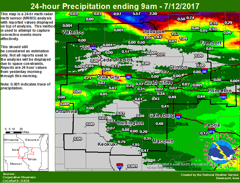
| Figure 1: Local 24-hr Rainfall |
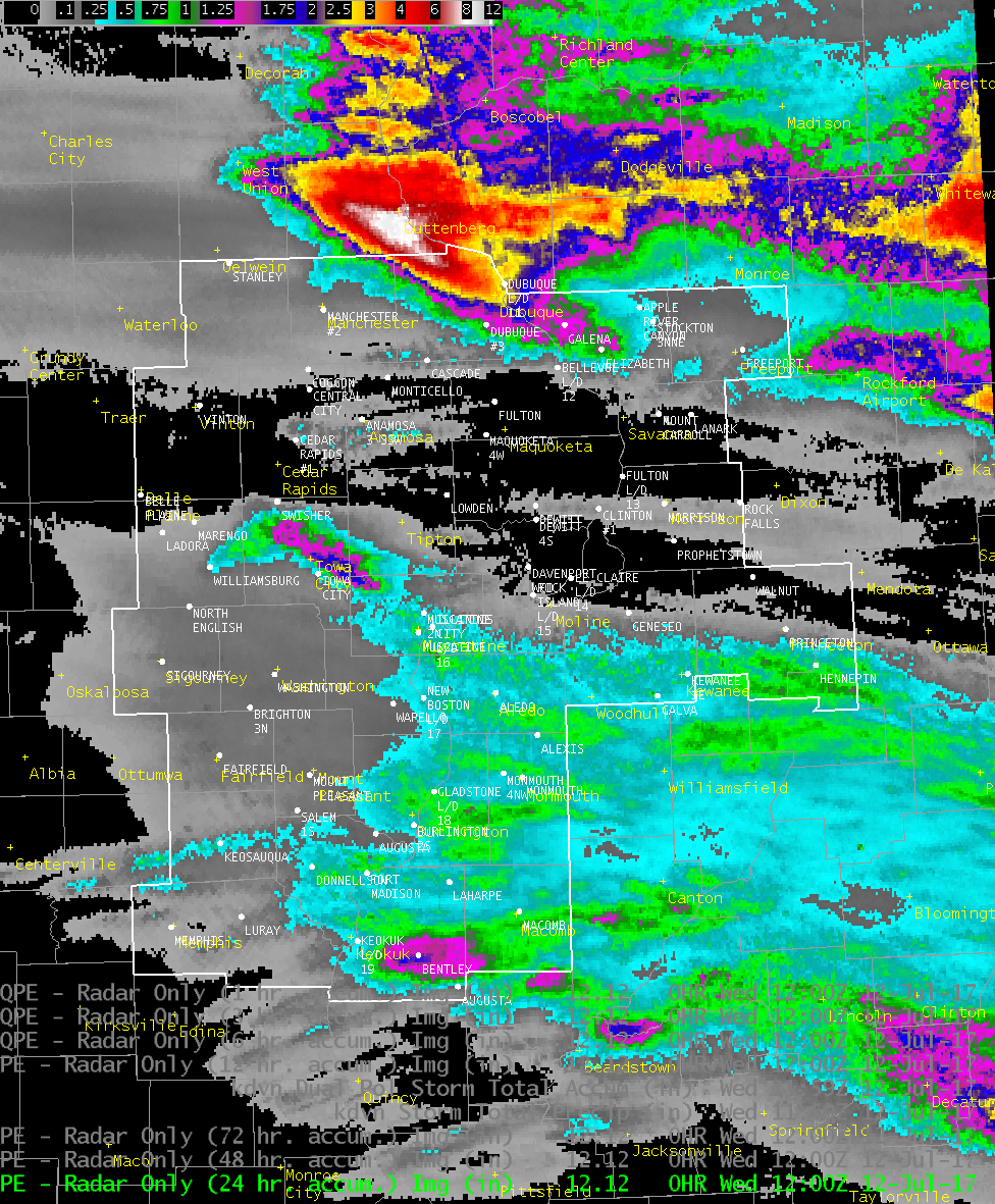
Figure 2: Multiple-Radar/ Multiple-Sensor Estimated Rainfall Ending 11 am 07/12/17 |
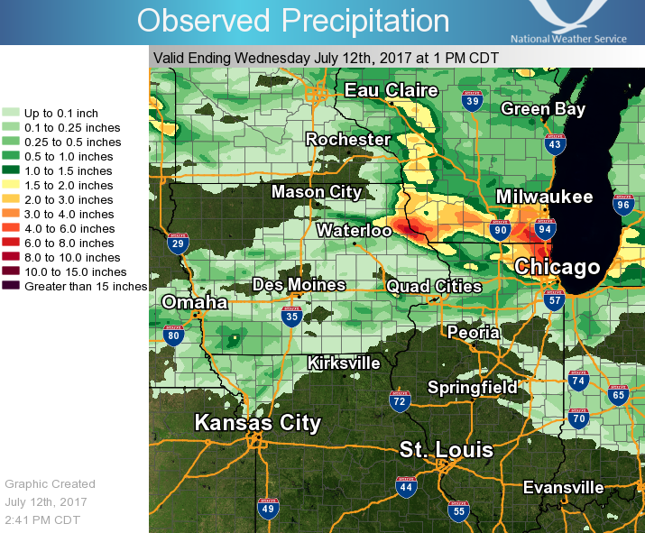
Figure 3: Regional 24-hr Rainfall |
24 hour precipitation reports (in Inches),
for eastern Iowa, northwest and west central Illinois,
and northeast Missouri. Reported between Midnight and 9 AM,
Wednesday July 12, 2017.

....IOWA....
Guttenberg Dam 10                5.57
Dubuque LD11                     2.62
Peosta 2.9 E                     1.95
Dubuque #3                       1.51
Dubuque Arpt                     1.43
Elkader 6SSW                     0.97
North Liberty 1.0 ENE            0.86
Keokuk LD19                      0.79
Muscatine 1.4 N                  0.70
Cascade                          0.50
Muscatine 2N                     0.32
Burlington Arpt                  0.27
Parnell 0.1 SSW                  0.21
Anamosa 3 SSW                    0.17
Solon 0.3 ESE                    0.13
Beaconsfield                     0.12
Burlington 6.5 SSW               0.08
Park View 0.2 WSW                0.07
Donnellson                       0.07
Iowa City 4.5 N                  0.07
Washington                       0.05
Hampton                          0.05
Amana 4.7 W                      0.05
Iowa City                        0.04
Tripoli                          0.03
Fayette                          0.03
New London 1.5 SW                0.03
Iowa City Arpt                   0.03
Salem 3.1 ESE                    0.02
Camanche 1.2 W                   0.02
West Point 7.5 NW                0.02
Kalona 7.3 NNW                   0.02
Ainsworth 7.4 N                  0.02
Ames US 30                       0.02
Ely 0.5 SE                       0.02
New London 0.5 ESE               0.02
Bellevue LD12                    0.01
Mason City ASOS                  0.01
Delmar 2.3 NW                    0.01
Maquoketa 4W                     0.00
Waterloo ASOS                    0.00
Central City 6.7 W               0.00
Eldridge 0.7 SSW                 0.00
Ottumwa ASOS                     0.00
Marion 1.2 NE                    0.00
Marengo                          0.00
Eldridge 0.6 ESE                 0.00
Mason City*                      0.00
Cedar Rapids Arpt                0.00
Manchester                       0.00
Cedar Rapids 2.2 WSW             0.00
Oskaloosa AWOS                   0.00
Pella                            0.00
Marshalltown ASOS                0.00
Bettendorf 2.2 SE                0.00
Lowden                           0.00
Robins 0.4 SSE                   0.00
Marshalltown                     0.00
Marion 1.7 NNW                   0.00
Mount Auburn 2.2 NNW             0.00
Monticello                       0.00
Oelwein AWOS                     0.00
Toledo                           0.00
Cedar Rapids 3.4 NW              0.00
Center Point 0.6 NNW             0.00
Grinnell                         0.00
NWS Johnston*                    0.00
Centerville                      0.00
Grinnell AWOS                    0.00
Perry                            0.00
Davenport Arpt                   0.00
Gilman                           0.00
Cresco                           0.00
Mason City                       0.00
Vinton                           0.00
Davenport 0.9 WNW                0.00
Boone                            0.00
Pella AWOS                       0.00
Le Claire 1.8 NNE                0.00
Keosauqua                        0.00
Rathbun Reservoir                0.00
Sigourney                        0.00
Fairfield                        0.00
Davenport 0.9 SSW                0.00
....ILLINOIS....
Mundelein                        2.59
Bentley                          1.95
Decatur Airport                  1.69
Galena                           1.53
Lincoln NWS                      1.32
Elizabeth                        1.09
New Boston LD17                  0.61
New Windsor 2.0 N                0.49
Roseville 0.6 WNW                0.48
Augusta                          0.47
Kewanee                          0.44
Aledo                            0.43
Alexis                           0.41
Bloomington Airport              0.37
Colchester 3.5 NE                0.35
Milan 8.8 SSW                    0.34
Galesburg Arpt                   0.33
Ill. City LD16                   0.31
Macomb 3.8 NW                    0.28
Rockford ASOS                    0.24
Ridott 0.1 NE                    0.20
La Harpe                         0.20
Peoria ASOS                      0.17
Jacksonville AWOS                0.16
Streator                         0.13
Roscoe 2SE                       0.13
Pearl City 0.4 SW                0.11
Orangeville 2.8 NW               0.10
Gladstone LD18                   0.08
Davis 0.5 N                      0.06
Shannon 0.2 S                    0.05
Winslow 4.3 ESE                  0.05
Freeport 1.7 ESE                 0.02
Moline 0.7 NNE                   0.02
Coal Valley 1.9 SE               0.02
Moline 1.0 WNW                   0.02
Geneseo 2.0 NW                   0.02
Princeton 1.5 S                  0.02
Moline 0.9 N                     0.01
Freeport 2.0 NW                  0.01
Quad City Arpt                   0.01
Romeoville                       0.00
Princeton 1.1 SE                 0.00
Freeport                         0.00
Princeton                        0.00
Quincy ASOS                      0.00
St Anne                          0.00
Mendota                          0.00
Atkinson 2.6 NNE                 0.00
Chadwick 2.7 WSW                 0.00
Ottawa                           0.00
Steward                          0.00
Rochelle AWOS                    0.00
Morrison 3.2 E                   0.00
Dallas City 3.0 SSE              0.00
Joliet                           0.00
Morrison                         0.00
Rochelle                         0.00
Fulton 0.8 SSW                   0.00
Walnut                           0.00
Paw Paw                          0.00
....MISSOURI....
Memphis                          0.00
Chillicothe                      0.00
Columbia                         0.00
Kirksville ASOS                  0.00
....WISCONSIN....
Sullivan-NWS                     3.84
Lancaster 4WSW                   2.30
La Crosse WFO                    1.74
Whitewater                       1.62
Prairie du Chien AWOS            1.59
Steuben 4SE                      1.49
Viroqua                          1.42
Darlington-2 NE                  0.74
Darlington                       0.50
Allenton-WWTP                    0.30
Brodhead                         0.29
Madison-ASOS                     0.25
Monroe                           0.18
Beloit-College                   0.17
South Wayne-4 SW                 0.06
Watertown-AWOS                   0.00
....MINNESOTA....
Theilman 1SSW                    1.14
Preston                          0.05
Byron 4N                         0.00
Grand Meadow                     0.00
Environment
 |
 |
|
| 7/12/17 DVN 00z | 7/11/17 DVN 18z |
 |
 |
 |
| Precipitable Water 00z | Sig Tor Parameter 23z | 0-1 km shear 23z |
 |
Media use of NWS Web News Stories is encouraged! Please acknowledge the NWS as the source of any news information accessed from this site. |
|


.JPG)