Dangerous heat will expand from the Gulf Coast into the Southern Plains and Desert Southwest through week's end. Additional extreme heat impacting the Pacific Northwest will shift to the northern Plains by the weekend. Tropical Storm Bertha is expected to continue to impact portions of the northern Gulf Coast from the western Florida Panhandle to southeastern Louisiana through tonight. Read More >
 |
 |
 |
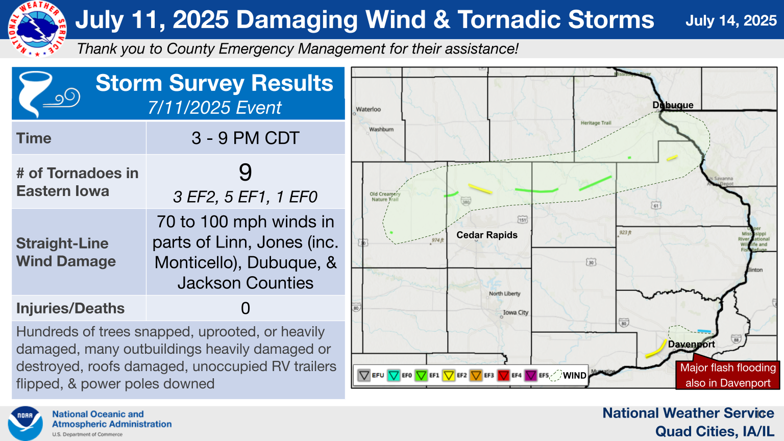
| Event Summary | Severe Weather & Tornadoes | Davenport EF2 Tornado |
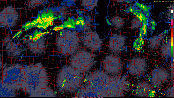
Tornadoes
Select a tornado from the table to zoom into the track and view more information. The default table view is limited to 8 tracks, but can be scrolled by a mouse wheel or dynamically expanded. Additionally, the table can fill the entire window by clicking the small circular expanding arrow icon at the very top right of the table and returned to its original size by clicking the button again. The side information panel that opens over the map can be closed using the "X" on the upper right corner of the pop-up. Zoom into the map and click damage points to see detailed information and pictures from the surveys.
Public Information Statement on July 11th Event Damage Surveys
|
NOTE: times shown below are local to your device's time zone. |

The Enhanced Fujita (EF) Scale classifies tornadoes into the following categories:
| EF0 Weak 65-85 mph |
EF1 Moderate 86-110 mph |
EF2 Significant 111-135 mph |
EF3 Severe 136-165 mph |
EF4 Extreme 166-200 mph |
EF5 Catastrophic 200+ mph |
 |
|||||
| Tornadoes that fail to impact any ratable damage indicators on the EF-Scale are rated EF-Unknown (EF-U) | |||||
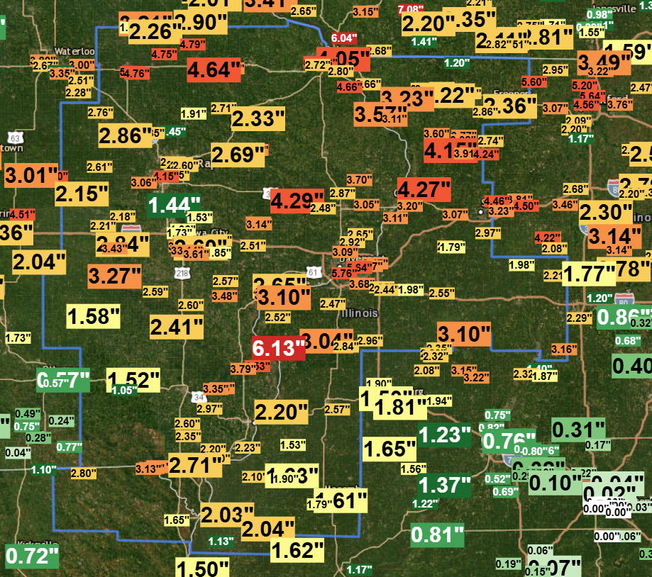
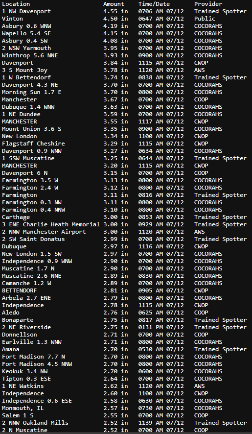
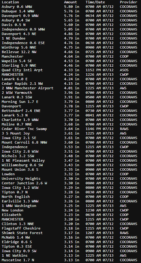
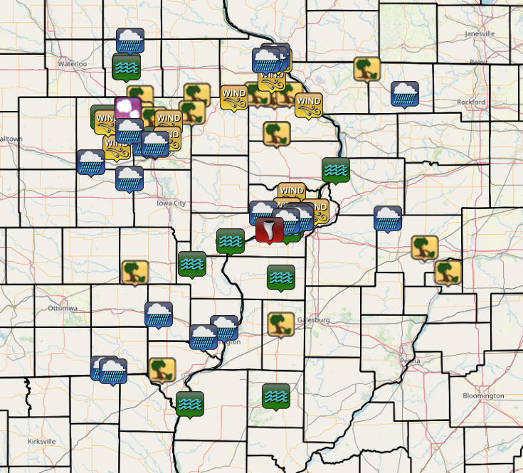
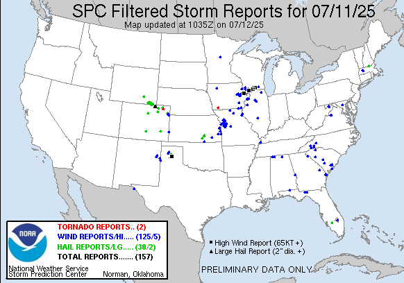
Storm Reports
| Interactive Storm Reports - Courtesy IEM | SPC Storm Reports: July 11, 2025 |
 |
 |
Preliminary Local Storm Report...Summary
National Weather Service Quad Cities IA IL
..TIME... ...EVENT... ...CITY LOCATION... ...LAT.LON...
..DATE... ....MAG.... ..COUNTY LOCATION..ST.. ...SOURCE....
..REMARKS..
0320 PM Tornado 3 ENE Keystone 42.01N 92.15W
07/11/2025 Benton IA NWS Storm Survey
EF1 tornado with peak winds of 105 mph hit a
farm outbuilding around 320 PM. The path
continued through corn hitting a house,
snapping some trees and destroying a garage
at the end of its 0.7 mile long and 20 yd
wide path.
0321 PM Rain 1 SSE Edmore 42.54N 90.68W
07/11/2025 M1.63 Inch Dubuque IA Trained Spotter
1.63 inches in 37 minutes.
0324 PM Non-Tstm Wnd Gst 5 N Koszta 41.90N 92.18W
07/11/2025 M41 MPH Benton IA Trained Spotter
0325 PM Tstm Wnd Dmg 4 N Brighton 41.23N 91.82W
07/11/2025 Washington IA Trained Spotter
Photo of tree snapped near the base. Time
estimated by radar.
0331 PM Tstm Wnd Gst 2 SW Vinton 42.14N 92.04W
07/11/2025 M71 MPH Benton IA Public
From PWS.
0335 PM Tornado 4 WSW Center Point 42.16N 91.85W
07/11/2025 Benton IA NWS Storm Survey
This tornado tracked through some rural
residences and wooded areas near the Cedar
River in far eastern Benton and far western
Linn Counties. Damage was mainly to trees,
including numerous uprooted or snapped,
though a few homes and garages had roof
damage. The tornado ended on the south end
of Center Point. Within the town of Center
Point, damage appeared to be due to
straight-line winds.
0338 PM Tstm Wnd Gst Shellsburg 42.09N 91.87W
07/11/2025 M45 MPH Benton IA Trained Spotter
0339 PM Tstm Wnd Gst Newhall 41.99N 91.97W
07/11/2025 M70 MPH Benton IA Public
0340 PM Tstm Wnd Dmg Center Point 42.19N 91.78W
07/11/2025 Linn IA NWS Storm Survey
Widespread tree damage throughout town.
0342 PM Tstm Wnd Dmg 2 WNW Center Point 42.19N 91.82W
07/11/2025 Linn IA Emergency Mngr
Power out with damage to trees and a gazebo.
Tree branches down.
0344 PM Hail Urbana 42.22N 91.88W
07/11/2025 E0.88 Inch Benton IA Trained Spotter
Dime to nickel hail occurring right now.
0344 PM Tstm Wnd Dmg Urbana 42.22N 91.88W
07/11/2025 Benton IA Emergency Mngr
Half of a maple tree down in the city.
0345 PM Rain 1 NW Dubuque 42.52N 90.70W
07/11/2025 M1.67 Inch Dubuque IA Trained Spotter
0345 PM Tstm Wnd Dmg Center Point 42.19N 91.78W
07/11/2025 Linn IA Trained Spotter
Top half of a very large tree down.
0346 PM Tornado 4 ENE Center Point 42.21N 91.71W
07/11/2025 Linn IA NWS Storm Survey
This tornado intensified rapidly after
development, and there was a visual from a
farmstead to the north of the tornado
developing. A dozen large trees at the first
homestead hit were downed, some thrown, and
heavy outbuilding, garage, and home roof
damage. Further there were other
homesteads/farmsteads that had outbuilding
damage, utility poles downed (in one case
thrown), and many trees snapped.
0346 PM Tstm Wnd Dmg Walker 42.29N 91.78W
07/11/2025 Linn IA Trained Spotter
Some trees snapped. A mobile home damaged.
Time estimated.
0349 PM Flash Flood Independence 42.47N 91.90W
07/11/2025 Buchanan IA Public
Report from mPING: Street/road flooding;
Street/road closed; Vehicles stranded.
0351 PM Rain 1 S Asbury 42.51N 90.76W
07/11/2025 M2.75 Inch Dubuque IA Trained Spotter
Ocurred in the past hour.
0352 PM Flash Flood Vinton 42.17N 92.07W
07/11/2025 Benton IA Trained Spotter
Reports street flooding in Vinton.
0354 PM Tstm Wnd Gst 3 NNE Cedar Rapids 42.01N 91.66W
07/11/2025 E70 MPH Linn IA Trained Spotter
Estimated wind gusts of 60 to 70 MPH. Na
damage reported.
0354 PM Tstm Wnd Gst 4 ESE Alburnett 42.14N 91.55W
07/11/2025 M55 MPH Linn IA Emergency Mngr
Hwy 13 and Indian Bridge Rd.
0356 PM Tstm Wnd Gst 2 NNE Cedar Rapids 42.00N 91.66W
07/11/2025 E60 MPH Linn IA Trained Spotter
Half inch tree limbs coming down.
0358 PM Tstm Wnd Dmg 1 NE Lafayette 42.16N 91.67W
07/11/2025 Linn IA Emergency Mngr
Widespread reports across the northern part
of the county of trees down.
0358 PM Tstm Wnd Dmg 1 SSE Center Point 42.17N 91.77W
07/11/2025 Linn IA Emergency Mngr
Semi blown over on I-380. Also widespread
reports of trees down across the northern
part of the county.
0400 PM Tstm Wnd Dmg 3 NNW Cedar Rapids 42.01N 91.68W
07/11/2025 Linn IA Trained Spotter
Very large tree snapped off 10 feet above
the ground blocking the road.
0404 PM Tornado 1 NNE Waubeek 42.19N 91.46W
07/11/2025 Linn IA NWS Storm Survey
This tornado developed just east of the
Wapsipinicon River in Linn County and
crossed into Jones County ending near U.S.
Highway 151. Snapped large trees were found
at a few locations, along with roof damage
to a mobile home.
0410 PM Non-Tstm Wnd Gst 1 WSW Norway 41.90N 91.95W
07/11/2025 M35 MPH Benton IA Mesonet
Mesonet station UR395 28thaw.
0410 PM Rain 4 SW Hiawatha 42.01N 91.73W
07/11/2025 M1.50 Inch Linn IA Public
Rainfall in 20 min.
0411 PM Flash Flood 1 N Independence 42.48N 91.89W
07/11/2025 Buchanan IA Public
Report from mPING: Street/road flooding;
Street/road closed; Vehicles stranded.
0412 PM Tstm Wnd Dmg 4 SE Prairieburg 42.20N 91.36W
07/11/2025 Linn IA CO-OP Observer
NWS cooperative observer relayed damage
photos of a large tree that was split near
the base. Time estimated by radar.
0413 PM Tstm Wnd Gst 1 E Marion 42.04N 91.56W
07/11/2025 M64 MPH Linn IA Trained Spotter
0417 PM Tstm Wnd Dmg 3 SE Buck Creek 42.30N 91.32W
07/11/2025 Delaware IA Trained Spotter
Photos and video relayed on X of a large
tree uprooted at a farmstead along with a
blown down shed. Time estimated by radar.
0418 PM Tstm Wnd Dmg Monticello 42.24N 91.19W
07/11/2025 Jones IA NWS Storm Survey
Widespread tree damage in town and extending
northward along Highway 38 to near Sand
Springs in Delaware County.
0419 PM Rain 5 N Koszta 41.90N 92.18W
07/11/2025 M1.64 Inch Benton IA Trained Spotter
Occurred in the past hour.
0420 PM Tornado 1 N Scotch Grove 42.18N 91.10W
07/11/2025 Jones IA NWS Storm Survey
This tornado tracked through wooded areas of
northeast Jones County. Significant tree
damage occurred, including along the
Maquoketa River such as in the Ebys Mill
Wildlife area.
0435 PM Tstm Wnd Gst 1 SSW Cascade 42.29N 91.02W
07/11/2025 M85 MPH Jones IA Emergency Mngr
Possible gusts to 90 mph.
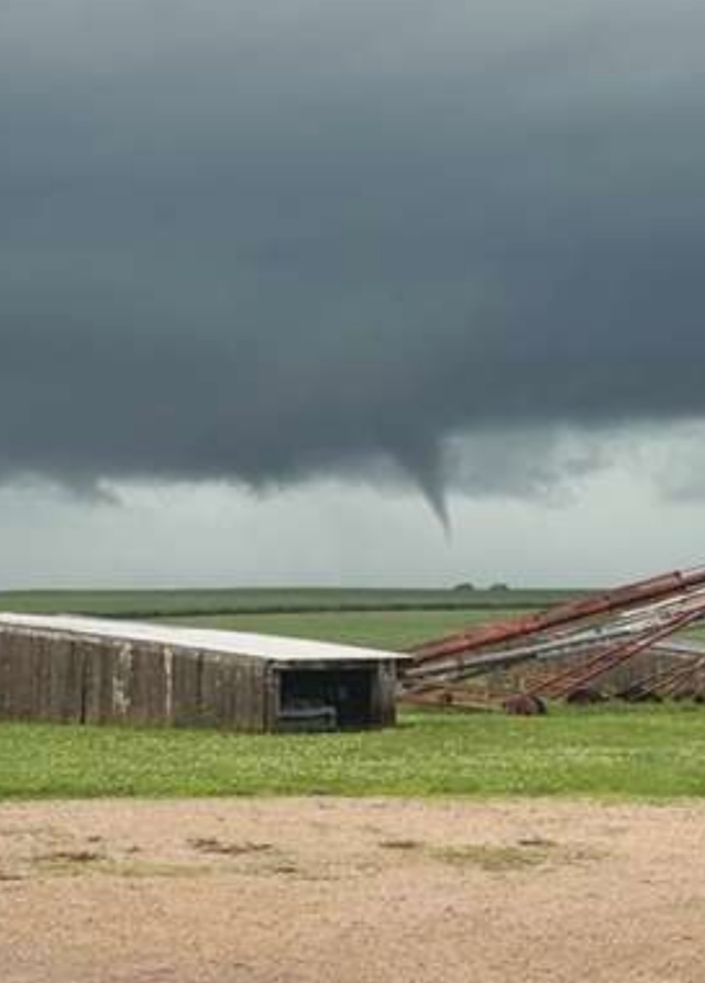
0445 PM Tornado Bernard 42.31N 90.83W
07/11/2025 Dubuque IA NWS Storm Survey
A 0.8 mile long EF1 tornado with peak wind
speeds of 95 mph caused damage to trees and
a county road maintenance shed in Bernard.
This tornado was surrounded by straight line
wind damage with winds from 80 to 90 MPH.
0445 PM Tstm Wnd Dmg 1 NNE Bernard 42.33N 90.83W
07/11/2025 Dubuque IA NWS Storm Survey
Many trees with trunks snapped at location.
0446 PM Tstm Wnd Dmg Bernard 42.31N 90.83W
07/11/2025 Dubuque IA Public
Numerous trees down with main road in town
blocked. Delayed report.
0450 PM Tstm Wnd Dmg Maquoketa 42.07N 90.67W
07/11/2025 Jackson IA Broadcast Media
Several 4 to 6 inch tree limbs down in
Maquoketa. Time of the event was estimated
using radar.
0454 PM Tornado 1 NNE La Motte 42.30N 90.62W
07/11/2025 Jackson IA NWS Storm Survey
Evidence of a multiple vortex tornado EF2
tornado occurred across northern Jackson
County. The tornado started north of La
Motte where it damaged the roof of an
agriculture industry building. As it tracked
east the tornado did damage to trees until
halfway through its 2.6 mile path where the
most intense damage was found. A large farm
building lost it`s entire roof, along with
half of it`s walls. Roof sheet metal was
found north, south and east of the
structure. Insulation from the roof was
found on the north, south and east side of
the remaining walls. A metal power pole was
bent along with a few other wooden poles
snap. All this damage supported an EF2
tornado. As the tornado moved east it
destroyed two more farm buildings, numerous
trees and the roof of a house.
0456 PM Tstm Wnd Dmg Dubuque 42.51N 90.69W
07/11/2025 Dubuque IA Public
damage to swing set.
0456 PM Tstm Wnd Dmg Zwingle 42.30N 90.69W
07/11/2025 Dubuque IA Public
Large tree snapped near base. Time estimated
from radar.
0456 PM Tstm Wnd Dmg 3 ENE La Motte 42.31N 90.57W
07/11/2025 Jackson IA Trained Spotter
Several outbuildings destroyed along D55
between La Motte and Hwy 52. Power poles
leaning as well along road. Time estimated
from radar.
0458 PM Tstm Wnd Gst Dubuque Regional Arpt 42.40N 90.71W
07/11/2025 M59 MPH Dubuque IA ASOS
0500 PM Flash Flood 1 S Asbury 42.51N 90.76W
07/11/2025 Dubuque IA Trained Spotter
Delayed report. Water curb deep across the
entire road with storm sewers not keeping
up.
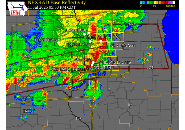
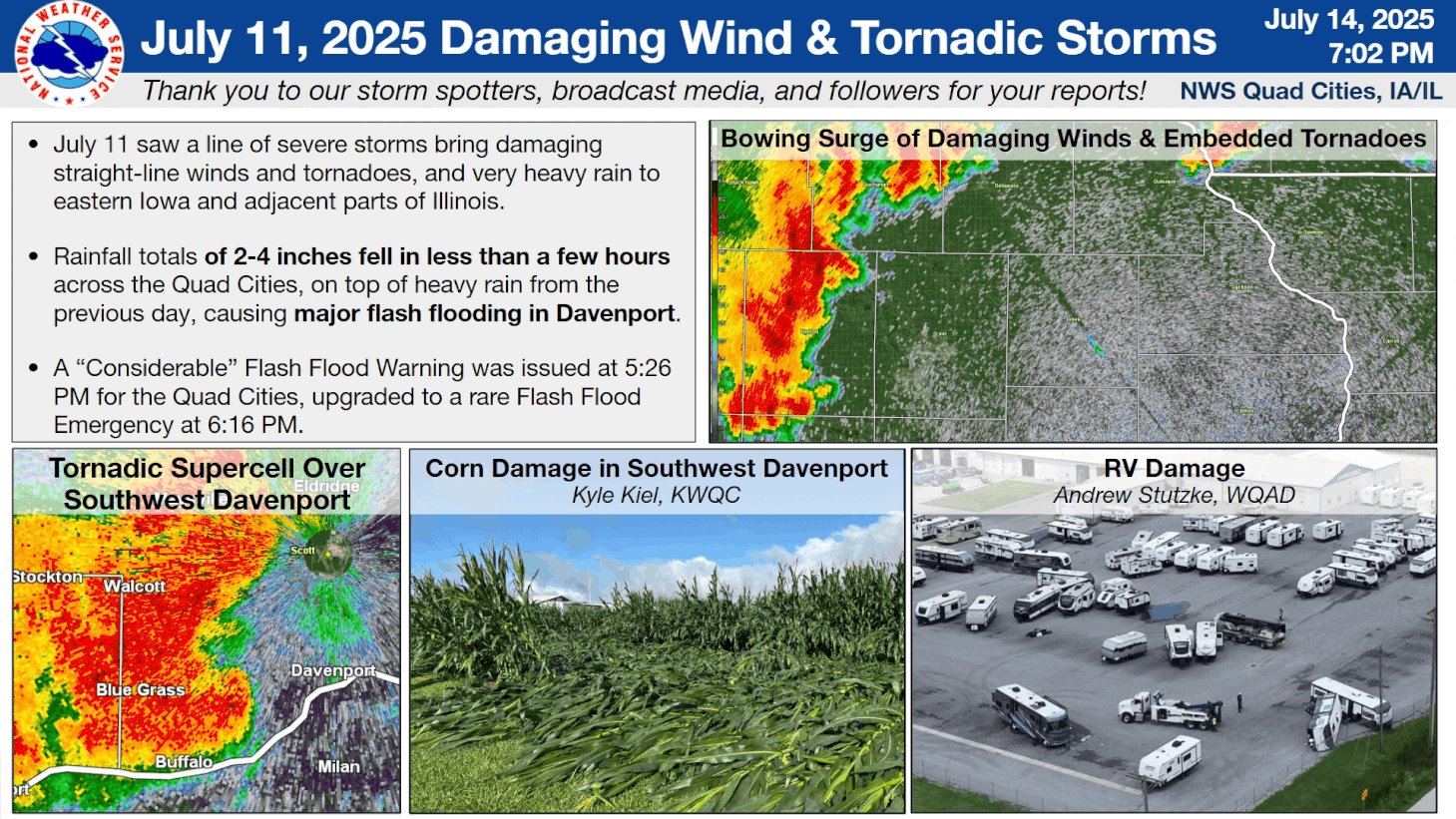
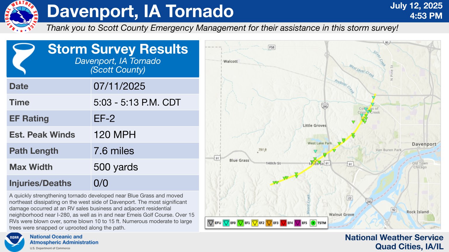
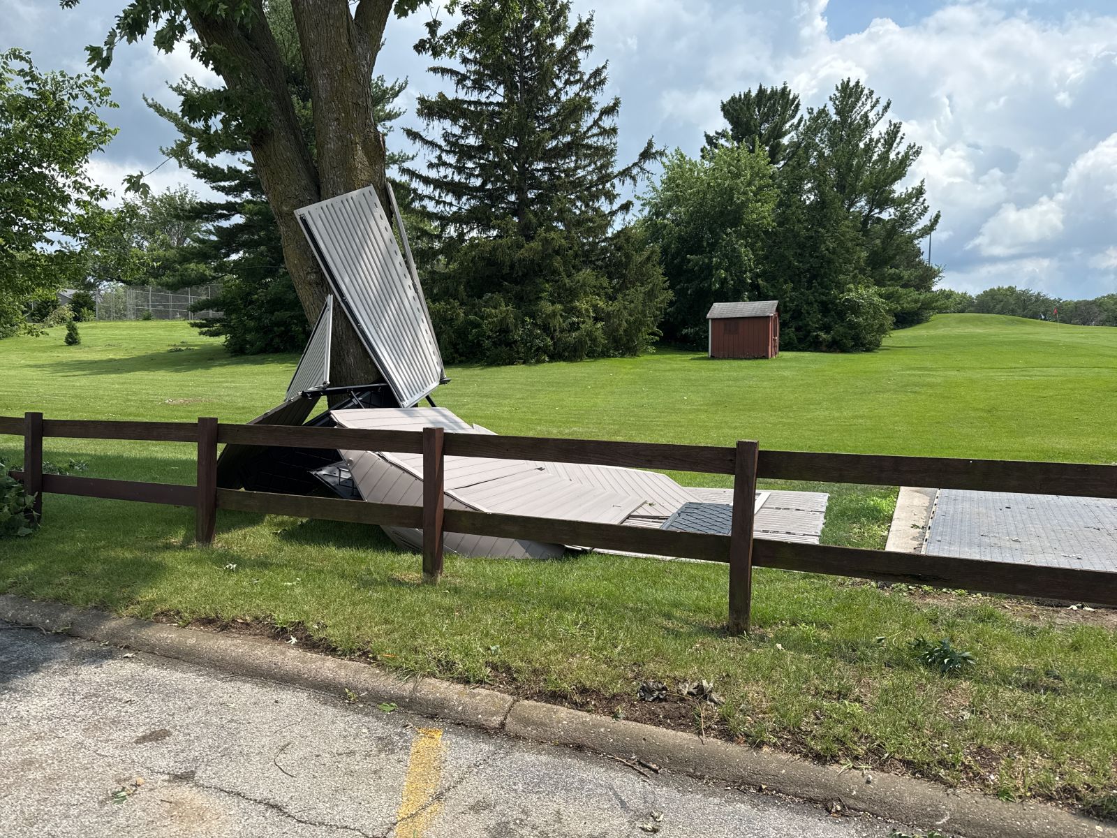
0503 PM Tornado 1 SSW Spring Lake 41.49N 90.73W
07/11/2025 Scott IA NWS Storm Survey
A quickly strengthening tornado developed
near Blue Grass and moved northeast
dissipating on the west side of Davenport.
It was rated EF-2 with peak winds to 120
mph. The most significant damage occurred at
an RV sales business and adjacent
residential neighborhood near I-280, as well
as in and near Emeis Golf Course. Over 15
RVs were blown over, some blown 10 to 15 ft.
Numerous moderate to large trees were
snapped or uprooted along the path.
0504 PM Tstm Wnd Gst 2 E Dubuque 42.51N 90.66W
07/11/2025 M60 MPH Dubuque IA Public
0504 PM Tstm Wnd Gst 2 SE Bellevue 42.24N 90.41W
07/11/2025 M56 MPH Jackson IA Public
From a PWS.
0507 PM Tstm Wnd Dmg Maquoketa 42.07N 90.67W
07/11/2025 Jackson IA Broadcast Media
Delayed report. Large tree branch down, with
several smaller tree limbs broken as well.
Time estimated from radar.
0509 PM Tstm Wnd Dmg Monmouth 40.91N 90.64W
07/11/2025 Warren IL Trained Spotter
1 to 2 inch tree limbs down.
0515 PM Flash Flood Independence 42.47N 91.89W
07/11/2025 Buchanan IA Trained Spotter
Water halfway up the tires on cars.
0515 PM Tstm Wnd Dmg Park View 41.69N 90.55W
07/11/2025 Scott IA NWS Employee
Delayed Report. Tree down along with several
3 inch diameter branches. Time estimated by
radar.
0520 PM Tstm Wnd Dmg 3 E Davenport 41.55N 90.55W
07/11/2025 Scott IA NWS Employee
Delayed report. Numerous tree branches down,
some 4-6 inches in diameter, along Duck
Creek Parkway between Brady Street and
Eastern Street. Tree also snapped. Time
estimated from radar.
0525 PM Flash Flood 1 ENE Dubuque 42.51N 90.67W
07/11/2025 Dubuque IA Trained Spotter
Water up to the bumpers on cars intersection
of 17th and Locus streets.
0525 PM Tstm Wnd Gst 1 NNW Park View 41.70N 90.55W
07/11/2025 M51 MPH Scott IA Trained Spotter
From PWS.
0526 PM Tstm Wnd Dmg 2 WNW Bettendorf 41.57N 90.51W
07/11/2025 Scott IA Public
2 inch tree limb down. Report was delayed.
Time of the event was estimated using radar.
0526 PM Tstm Wnd Gst Davenport Municipality 41.61N 90.59W
07/11/2025 M72 MPH Scott IA ASOS
From ASOS.
0532 PM Tstm Wnd Dmg 1 E Davenport 41.55N 90.58W
07/11/2025 Scott IA Public
Several large tree limbs down at 3200 N
Harrison.
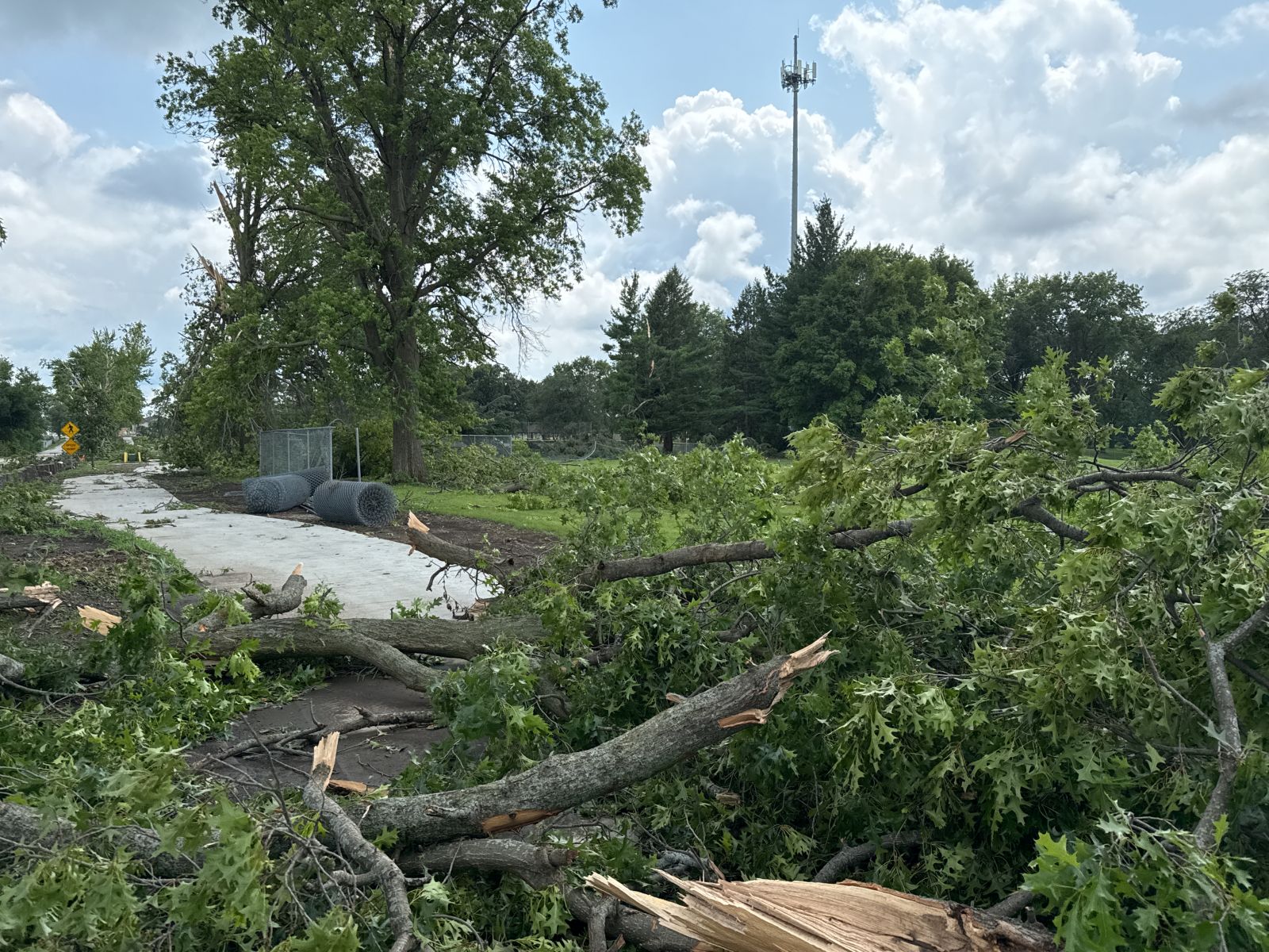
0533 PM Tornado 3 NNW Pleasant Valley 41.60N 90.45W
07/11/2025 Scott IA NWS Storm Survey
This short-lived tornado peeled a ~45 x 40
sheet metal section of an outbuilding roof
and threw it over 100 yards into a corn
field. There were also crop and minor tree
damage, and a nearby billboard with some
damage.
0534 PM Tstm Wnd Dmg Nora 42.46N 89.94W
07/11/2025 Jo Daviess IL Trained Spotter
Large trees down.
0535 PM Tstm Wnd Dmg Le Claire 41.60N 90.36W
07/11/2025 Scott IA Trained Spotter
Several trees down in LeClaire Time
estimated using radar.
0545 PM Flash Flood 1 SE Sageville 42.54N 90.69W
07/11/2025 Dubuque IA Law Enforcement
Water of over a foot on Iowa Highway 3 near
Northwest Arterial that caused the closing
of Highway 3. Other roads in the area
flooded too.
0550 PM Hail Davenport 41.55N 90.60W
07/11/2025 M1.00 Inch Scott IA Trained Spotter
Occurring right now.
0555 PM Tstm Wnd Dmg 3 W Mount Sterling 40.62N 92.00W
07/11/2025 Van Buren IA Trained Spotter
Delayed report. 12 inch diameter tree down.
0600 PM Flash Flood 2 NE Dubuque 42.52N 90.67W
07/11/2025 Dubuque IA Law Enforcement
Impassable roads due to water near Linwood
Cemetery.
0603 PM Flash Flood 2 NE Davenport 41.57N 90.58W
07/11/2025 Scott IA Public
On north Ripley near North High School.
Water over a foot deep and starting to enter
buildings.
0620 PM Flash Flood 2 ENE Clinton 41.85N 90.19W
07/11/2025 Clinton IA Trained Spotter
Report of 1 to 2 feet of water over the
roadways in this area, some of which was
moving at the time.
0623 PM Flash Flood 2 W Bettendorf 41.57N 90.51W
07/11/2025 Scott IA Trained Spotter
0625 PM Flash Flood 1 NW Rock Island 41.49N 90.59W
07/11/2025 Rock Island IL Public
Report from mPING: Street/road flooding;
Street/road closed; Vehicles stranded.
0631 PM Tstm Wnd Gst Le Claire 41.60N 90.36W
07/11/2025 M60 MPH Scott IA Trained Spotter
0638 PM Rain 2 ENE Hazleton 42.63N 91.86W
07/11/2025 M2.35 Inch Buchanan IA CO-OP Observer
From afternoon storms.
0639 PM Flash Flood 2 NNE Davenport 41.58N 90.58W
07/11/2025 Scott IA Trained Spotter
Corrects previous report from 2 NNE
Davenport. Reported Goose Creek out of its
banks on West 61st Street. Report of
basements flooding in the area.
0645 PM Tstm Wnd Dmg 2 WSW Donnellson 40.63N 91.60W
07/11/2025 Lee IA Trained Spotter
As storm and winds moved in, top of tree
knocked over. Time of the event estimated
using radar.
0648 PM Flash Flood 2 SW Davenport 41.54N 90.64W
07/11/2025 Scott IA Public
Water over car bumpers based on video.
0655 PM Flash Flood 2 E Davenport 41.55N 90.57W
07/11/2025 Scott IA Emergency Mngr
Delayed report. Multiple apartments along
35th Street near Duck Creek had their lowest
level completely flooded, some near to the
ceiling. Reports were that water rushed in
quickly. Time of onset estimated based on
safety official and media reports, with
flooding having continued through the night
of July 11.
0659 PM Rain 2 ENE Hazleton 42.63N 91.86W
07/11/2025 M1.79 Inch Buchanan IA CO-OP Observer
Since 7 AM this morning. Have had 2.25 since
yesterday morning.,.
0702 PM Flash Flood 1 E Muscatine 41.42N 91.05W
07/11/2025 Muscatine IA Public
Report from mPING: Street/road flooding;
Street/road closed; Vehicles stranded.
0710 PM Flash Flood 1 SW Shale City 41.20N 90.64W
07/11/2025 Mercer IL Public
Report from mPING: Street/road flooding;
Street/road closed; Vehicles stranded.
0711 PM Flash Flood 2 E Hiawatha 42.04N 91.64W
07/11/2025 Linn IA Public
Report from mPING: Street/road flooding;
Street/road closed; Vehicles stranded.
0719 PM Rain 4 NE Thomas 41.56N 89.77W
07/11/2025 M1.18 Inch Bureau IL Trained Spotter
fell in 1 hour. Automated gauge.
0723 PM Flash Flood 3 N Rock Island 41.51N 90.57W
07/11/2025 Rock Island IL Public
Intersection of River Drive and 19th street
in Moline.
0724 PM Flash Flood Davenport 41.55N 90.61W
07/11/2025 Scott IA Trained Spotter
Duck Creek at Pine St, Davenport, Ia,
completely out of its banks. Field flooded
behind Williams Middle School, N Division.
0732 PM Flash Flood 2 E Davenport 41.56N 90.57W
07/11/2025 Scott IA Broadcast Media
Live video broadcast news feed showing water
over 3 feet deep on 35th street just west of
Harrison Street in Davenport.
0736 PM Rain 2 NNW Oakland Mills 40.97N 91.63W
07/11/2025 M2.29 Inch Henry IA Trained Spotter
Since 4 PM.
0800 PM Flash Flood Columbus Junction 41.28N 91.36W
07/11/2025 Louisa IA Law Enforcement
Numerous rural roads closed within the
county due to flash flooding and high water
this evening.
0800 PM Flash Flood Columbus Junction 41.28N 91.36W
07/11/2025 Louisa IA Law Enforcement
Several county roads closed within the
county due to flash flooding and high water.
0800 PM Tstm Wnd Dmg Princeton 41.38N 89.47W
07/11/2025 Bureau IL Law Enforcement
Reports of several trees and power lines
down throughout the county.
0807 PM Rain 3 ESE Davenport 41.55N 90.54W
07/11/2025 M2.50 Inch Scott IA Trained Spotter
Total rainfall so far.
0807 PM Tstm Wnd Dmg Florid 41.23N 89.28W
07/11/2025 Putnam IL Emergency Mngr
2 inch diameter tree limbs down.
0830 PM Rain 1 W Bettendorf 41.56N 90.49W
07/11/2025 M3.16 Inch Scott IA Trained Spotter
Total since 5 P.M.
0844 PM Rain Cantril 40.64N 92.07W
07/11/2025 M2.02 Inch Van Buren IA Trained Spotter
Storm total. Rain has ended at time of
observation.
0845 PM Flash Flood 1 NE Keokuk 40.42N 91.38W
07/11/2025 Lee IA Emergency Mngr
Water over River Road by the Keokuk Yacht
Club.
0854 PM Rain Shellsburg 42.09N 91.87W
07/11/2025 M1.96 Inch Benton IA Trained Spotter
0911 PM Rain 3 W Mount Sterling 40.62N 92.00W
07/11/2025 M2.80 Inch Van Buren IA Trained Spotter
Since 5 PM.
0913 PM Rain 1 NW Bettendorf 41.58N 90.48W
07/11/2025 M2.80 Inch Scott IA NWS Employee
Total rainfall since 5 pm.
0941 PM Flash Flood Macomb 40.47N 90.68W
07/11/2025 McDonough IL Law Enforcement
Water over several roads in Macomb including
Jackson Street to Ward Street, and on West
Washington Street from Johnson on westward.
1008 PM Rain 5 SE Sperry 40.89N 91.10W
07/11/2025 M2.02 Inch Des Moines IA Trained Spotter
1025 PM Rain 1 W Bettendorf 41.56N 90.49W
07/11/2025 M3.60 Inch Scott IA Trained Spotter
Rainfall since 5 pm.
1100 PM Rain Walcott 41.59N 90.78W
07/11/2025 M2.75 Inch Scott IA NWS Employee
rainfall since 4pm.
1105 PM Rain 2 W Bettendorf 41.57N 90.51W
07/11/2025 M3.56 Inch Scott IA Trained Spotter
storm total since 5 pm.
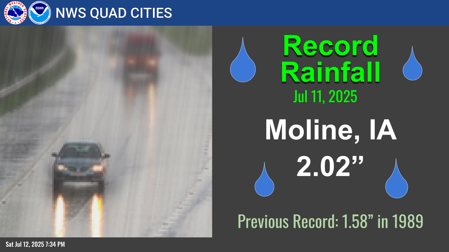
1133 PM Rain 1 SE Davenport 41.54N 90.60W
07/11/2025 M4.30 Inch Scott IA Trained Spotter
24-hr total.
1138 PM Rain 1 N Freeport 42.31N 89.63W
07/11/2025 M1.70 Inch Stephenson IL Trained Spotter
Storm total.
1145 PM Rain Middletown 40.83N 91.27W
07/11/2025 M2.50 Inch Des Moines IA Trained Spotter
24-hr total.
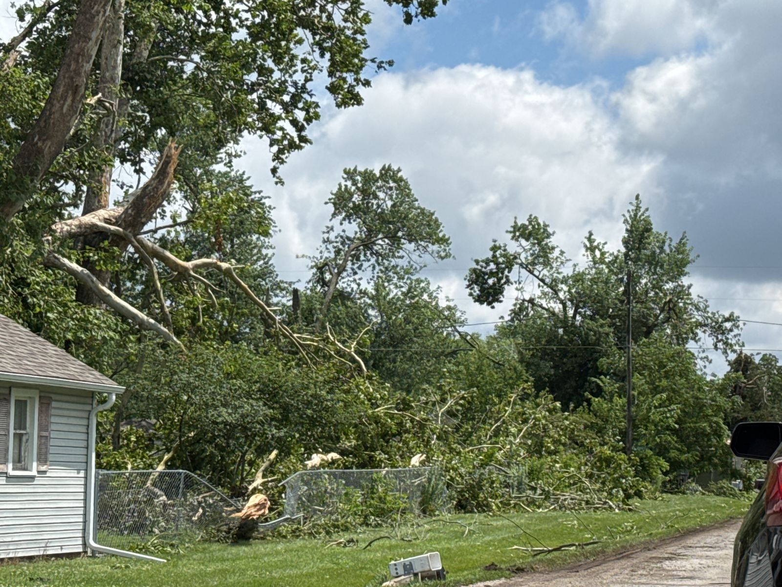
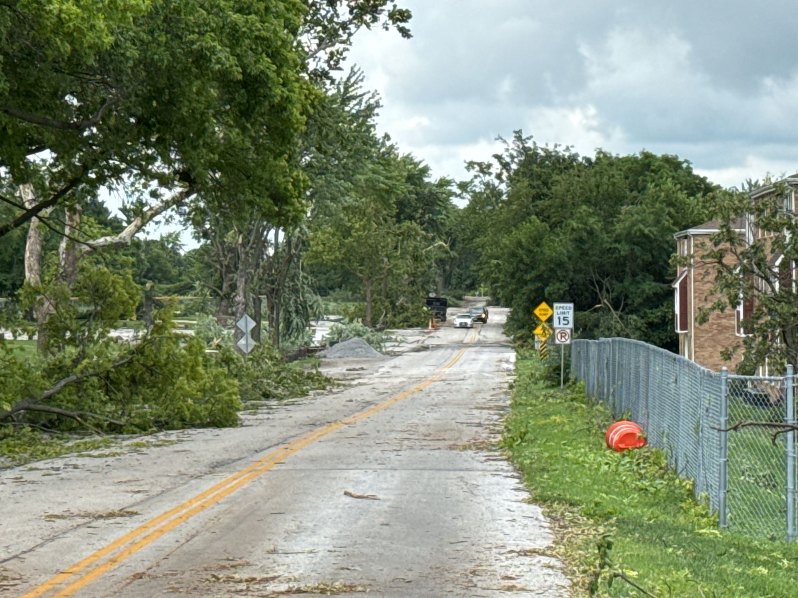
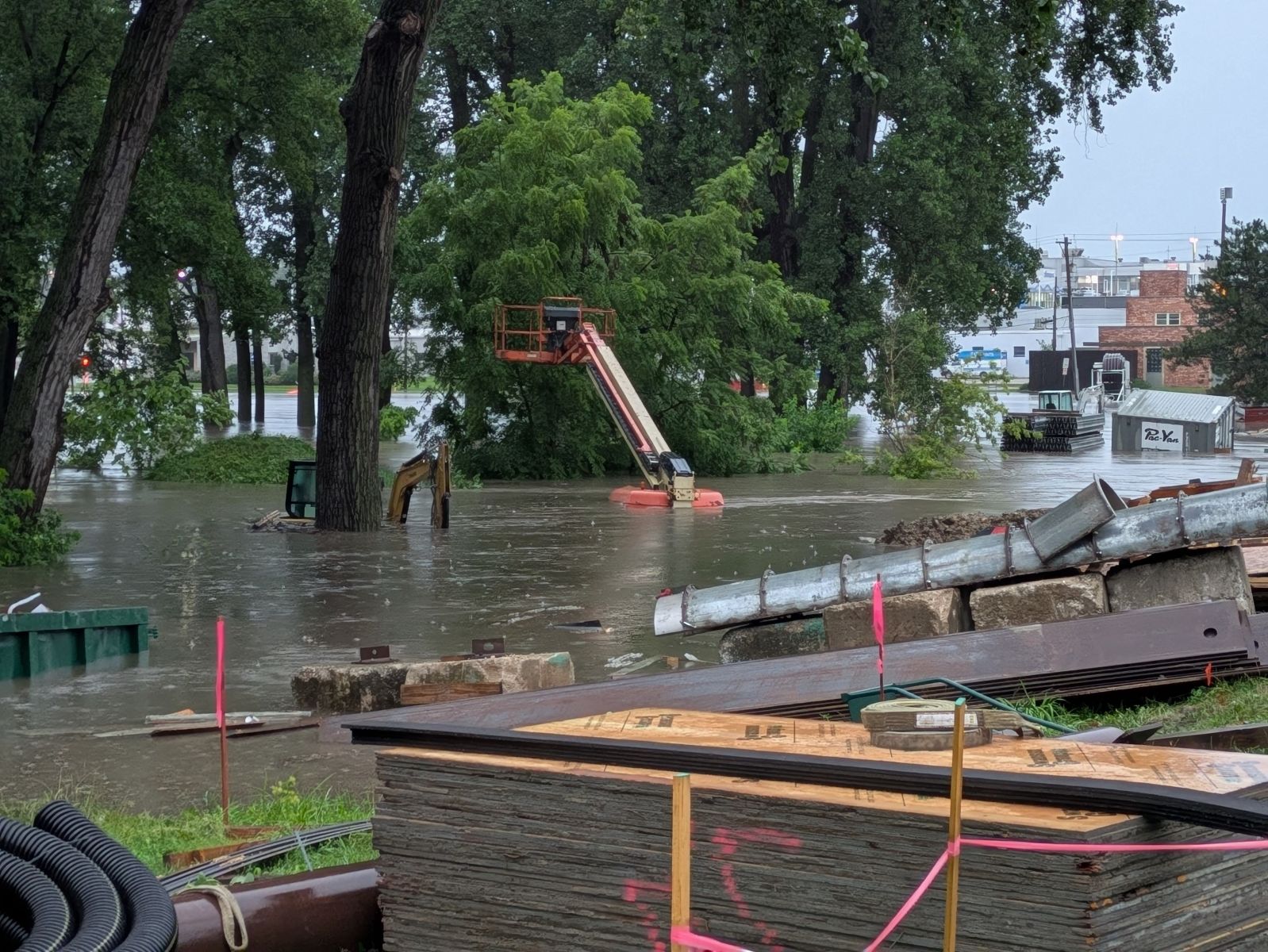
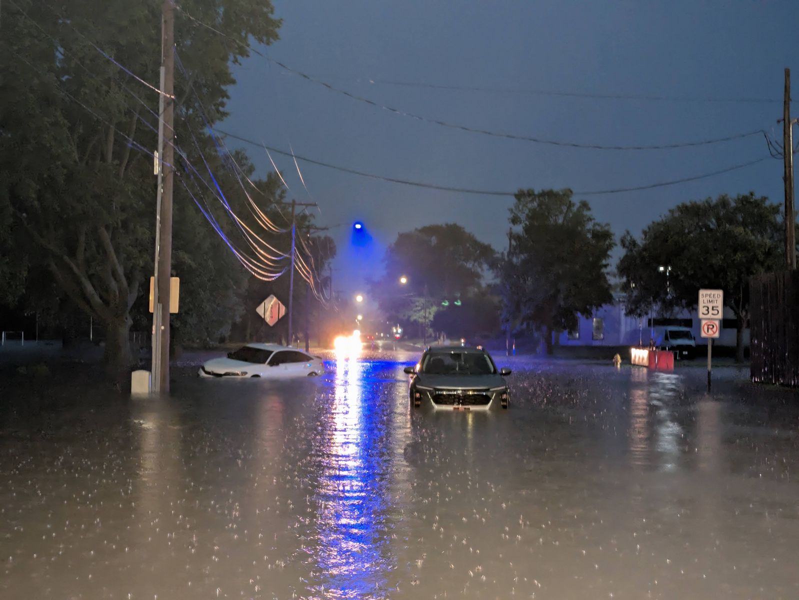
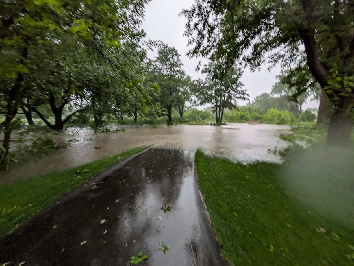
Photos & Video
 |
 |
|
|
| Start of EF2 tornado near Alburnett in Linn County, IA (Derek Rawson, with permission) |
Davenport, IA (NWS Survey) |
Davenport, IA (NWS Survey) |
Davenport, IA (NWS Survey) |
 |
 |
 |
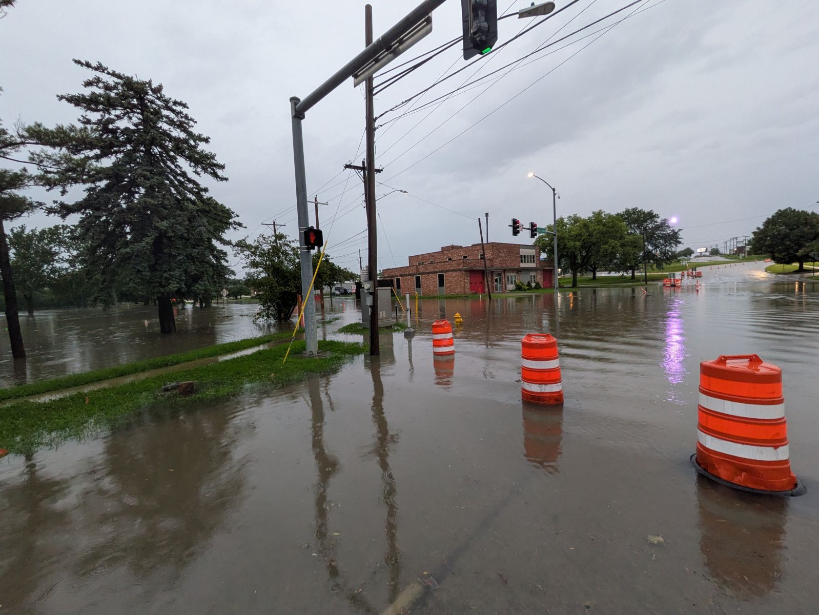 |
| Davenport, IA (NWS Survey) |
Davenport, IA (NWS Survey) |
N Harrison and Duck Creek Davenport, IA (Michael Morrow) |
N Harrison and 35th Davenport, IA (Michael Morrow) |
 |
.jpg) |
 |
.jpg) |
| N Harrison and 35th Davenport, IA (Michael Morrow) |
N Harrison and 32nd Davenport, IA (Michael Morrow) |
N Harrison and Duck Creek Davenport, IA (Michael Morrow) |
16th and Warren Davenport, IA (Nathan Truninger) |
Environment
 |
 |
 |
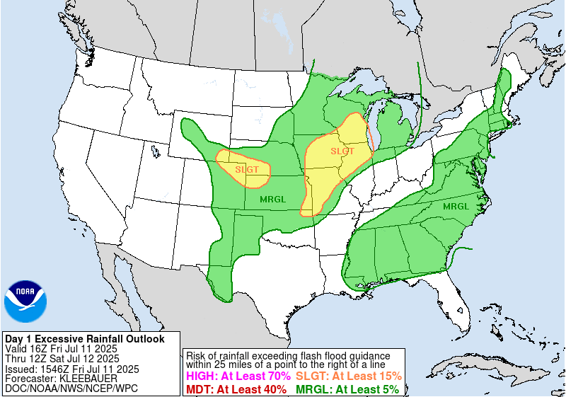 |
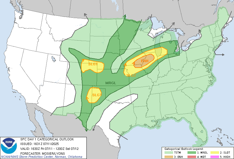
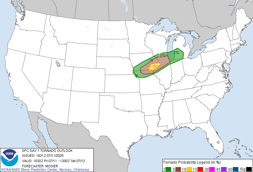
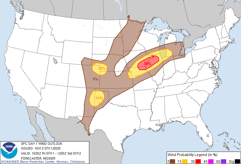
| Figure 1: SPC 1630z Day 1 Convective Outlook | Figure 2: SPC 1630z Day 1 Tornado Outlook | Figure 3: SPC 1630z Day 1 Wind Outlook | Figure 4: WPC Day 1 Excessive Rainfall Outlook |
|
|
 |
 |
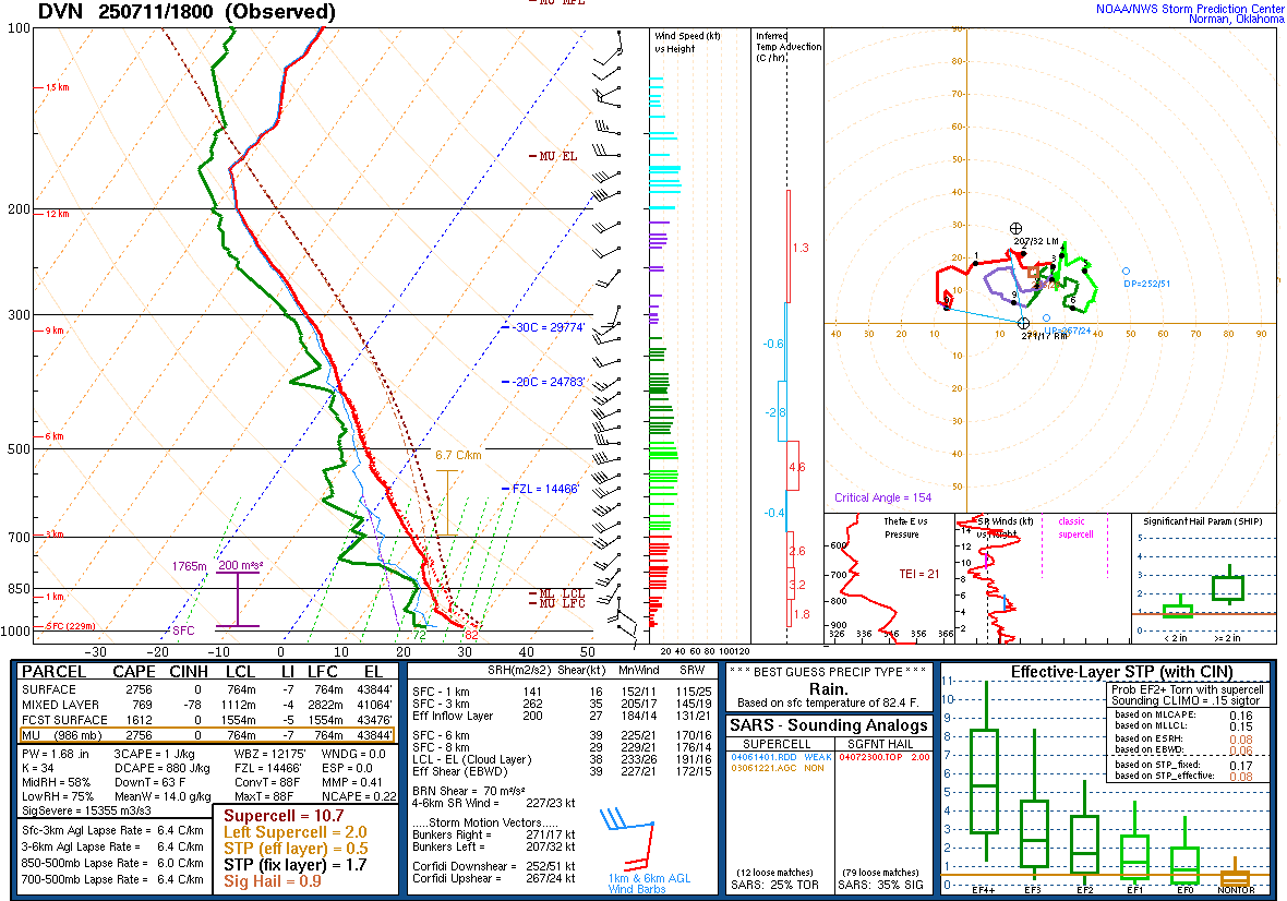
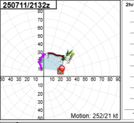
| Figure 5: Davenport 18z/1PM CDT Sounding | Figure 6: Davenport 4:32 PM CDT Doppler VAD Wind Profiler hodograph. | Figure 7: Mesoscale Discussion 1641 |
|
 |
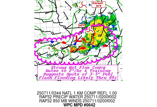 |
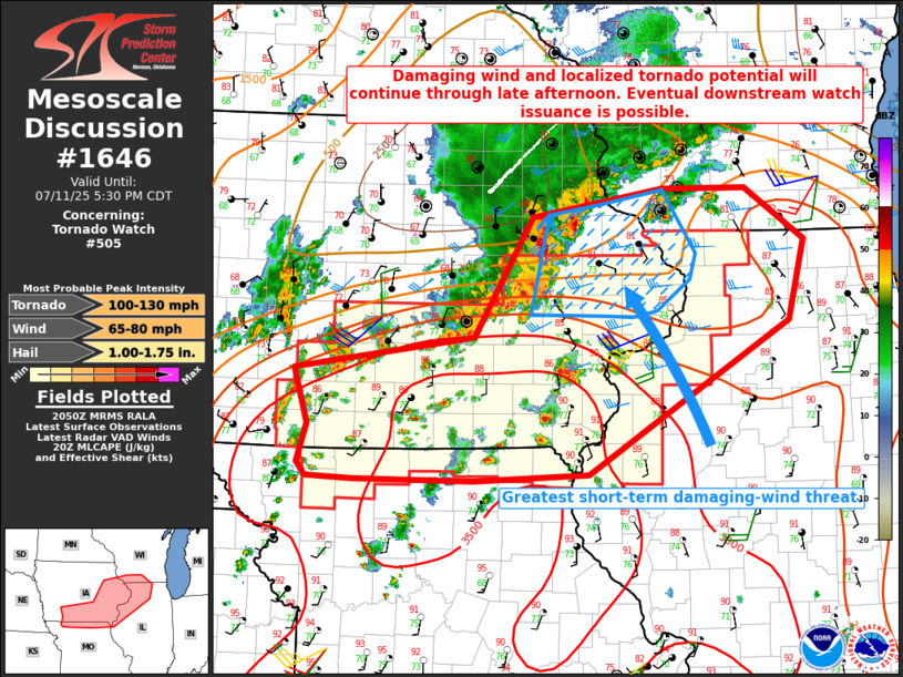
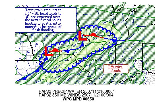
| Figure 8: Mesoscale Discussion 1646 | Figure 9: Mesoscale Precipitation Discussion 0650 | Figure 10: Mesoscale Discussion 0642 |
 |
Media use of NWS Web News Stories is encouraged! |
|