Life-threatening and locally catastrophic flash and urban flooding is expected across portions of south-central Texas through early Friday, with significant river flooding and rapid rises on small streams, arroyos, and typically dry washes expected. A significant heat wave continues for the Rockies, Northern Plains, and Great Lakes into the Mid-Atlantic, peaking in intensity through midweek. Read More >
Overview
|
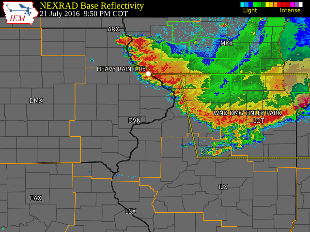
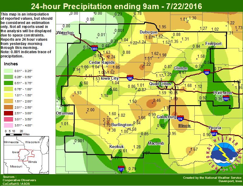
Hot and humid conditions were found across the Midwest on Thursday, July 21, 2016, as a warm front lifted north into the upper Great Lakes. A storm complex developed over southern Wisconsin during the evening and tracked southward into northern Illinois and eastern Iowa during the late evening of July 21 and early morning of July 22. Some of the stronger thunderstorms brought 50 to 70 mph winds over Stephenson, Jo Daviess, and Dubuque counties downing power lines and trees. Widespread rainfall was also common with most areas receiving over an inch of rain in a short amount of time. The highest rainfall amounts fell over southeast Iowa and west central Illinois. |
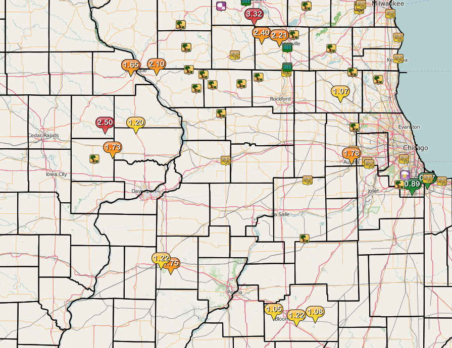
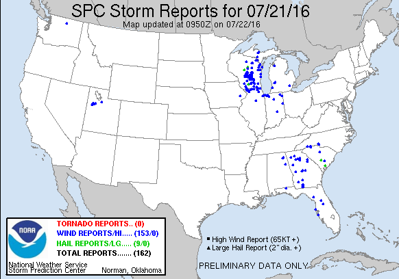
Storm Reports
| Interactive Map | SPC Storm Reports July 21, 2016 |
 |
 |
PRELIMINARY LOCAL STORM REPORT...SUMMARY
NATIONAL WEATHER SERVICE QUAD CITIES IA IL
820 AM CDT FRI JUL 22 2016

..TIME...   ...EVENT...      ...CITY LOCATION...     ...LAT.LON...
..DATE...   ....MAG....      ..COUNTY LOCATION..ST.. ...SOURCE....
            ..REMARKS..

0820 PM     TSTM WND DMG     LENA                    42.38N 89.83W
07/21/2016                   STEPHENSON         IL   EMERGENCY MNGR

            TREES DOWN IN THE AREA. TIME ESTIMATED.

0827 PM     TSTM WND DMG     APPLE RIVER             42.50N 90.09W
07/21/2016                   JO DAVIESS         IL   LAW ENFORCEMENT

            WINDS ESTIMATED TO BE 70 MPH HIT APPLE RIVER WITH TREES
            AND POWER LINES DOWN. STAGECOACH TRAIL WEST OF APPLE
            RIVER HAD WIRES DOWN. ALSO A TREE WAS ACROSS THE RAILROAD
            TRACKS ALONG STAGECOACH TRAIL.

0830 PM     TSTM WND DMG     ESE DAKOTA              42.39N 89.52W
07/21/2016                   STEPHENSON         IL   TRAINED SPOTTER

            GREATER THAN 2 INCH DIAMETER TREE LIMBS DOWN

0834 PM     TSTM WND DMG     1 ESE NORA              42.46N 89.93W
07/21/2016                   JO DAVIESS         IL   TRAINED SPOTTER

            4 INCH DIAMETER TREE BRANCH DOWN

0850 PM     TSTM WND DMG     SSE SHANNON             42.15N 89.74W
07/21/2016                   CARROLL            IL   TRAINED SPOTTER

            TREE BRANCHES DOWN. TIME ESTIMATED.

0910 PM     TSTM WND DMG     STOCKTON                42.35N 90.01W
07/21/2016                   JO DAVIESS         IL   LAW ENFORCEMENT

            TREES AND POWER LINES DOWN. TIME ESTIMATED.

0930 PM     TSTM WND GST     ROCK FALLS              41.77N 89.69W
07/21/2016  E55.00 MPH       WHITESIDE          IL   TRAINED SPOTTER

            ESTIMATED 50 TO 60 MPH WIND GUSTS. POWER OUT IN ROCK
            FALLS. HALF INCH DIAMETER BRANCHES DOWN AROUND TOWN. TIME
            ESTIMATED.

1000 PM     HEAVY RAIN       2 WNW DUBUQUE           42.52N 90.72W
07/21/2016  M1.05 INCH       DUBUQUE            IA   TRAINED SPOTTER

            IN PAST HALF HOUR. HEAVY RAIN FALLING AT THIS TIME.

1024 PM     TSTM WND GST     2 WNW CHARLOTTE         41.97N 90.50W
07/21/2016  M52.00 MPH       CLINTON            IA   TRAINED SPOTTER

            TIME ESTIMATED FROM RADAR.

1034 PM     HEAVY RAIN       2 WNW DUBUQUE           42.52N 90.72W
07/21/2016  M1.65 INCH       DUBUQUE            IA   TRAINED SPOTTER

            OVER ROUGHLY THE PAST HOUR.

1125 PM     TSTM WND DMG     1 NE TIPTON             41.78N 91.12W
07/21/2016                   CEDAR              IA   TRAINED SPOTTER

            A TREE A FOOT AND A HALF IN DIAMETER FELL DOWN.

1142 PM     HEAVY RAIN       SSW MAQUOKETA           42.06N 90.67W
07/21/2016  M1.20 INCH       JACKSON            IA   TRAINED SPOTTER

            OVER PAST 1.5 HOURS. MODERATE TO HEAVY RAIN AT THIS TIME.


1229 AM     HEAVY RAIN       LOWDEN                  41.86N 90.92W
07/22/2016  M1.73 INCH       CEDAR              IA   CO-OP OBSERVER

            OVER PAST 1.25 HOURS. HEAVY RAIN STILL FALLING.

1240 AM     HEAVY RAIN       WYOMING                 42.06N 91.00W
07/22/2016  M2.50 INCH       JONES              IA   EMERGENCY MNGR

0621 AM     HEAVY RAIN       COLUMBUS JUNCTION       41.28N 91.36W
07/22/2016  M2.50 INCH       LOUISA             IA   PUBLIC

            OVERNIGHT RAINFALL. VIA SOCIAL MEDIA.

0633 AM     HEAVY RAIN       N WELLMAN               41.47N 91.84W
07/22/2016  M1.25 INCH       WASHINGTON         IA   TRAINED SPOTTER

            RAIN FELL OVERNIGHT.

0634 AM     HEAVY RAIN       1 ESE MUSCATINE         41.41N 91.06W
07/22/2016  M2.00 INCH       MUSCATINE          IA   TRAINED SPOTTER

            ALL OF RAIN FELL OVERNIGHT.

0636 AM     HEAVY RAIN       2 WNW CHARLOTTE         41.97N 90.50W
07/22/2016  M1.50 INCH       CLINTON            IA   TRAINED SPOTTER

0700 AM     HEAVY RAIN       1 S SALEM               40.84N 91.62W
07/22/2016  M1.70 INCH       HENRY              IA   CO-OP OBSERVER

            24-HR TOTAL.

0700 AM     HEAVY RAIN       SIGOURNEY               41.33N 92.21W
07/22/2016  M1.93 INCH       KEOKUK             IA   CO-OP OBSERVER

            24-HR TOTAL.

0700 AM     HEAVY RAIN       ALEDO                   41.20N 90.75W
07/22/2016  M2.46 INCH       MERCER             IL   CO-OP OBSERVER

            24-HR TOTAL.

0700 AM     HEAVY RAIN       3 NE DUBUQUE            42.54N 90.65W
07/22/2016  M1.95 INCH       DUBUQUE            IA   CO-OP OBSERVER

            24-HR TOTAL.

0700 AM     HEAVY RAIN       LOWDEN                  41.86N 90.92W
07/22/2016  M2.22 INCH       CEDAR              IA   CO-OP OBSERVER

            24-HR TOTAL...MOST OF WHICH FELL IN LESS THAN 2 HRS
            BEFORE MIDNIGHT CST.

0700 AM     HEAVY RAIN       4 W MAQUOKETA           42.07N 90.74W
07/22/2016  M1.62 INCH       JACKSON            IA   CO-OP OBSERVER

            24-HR TOTAL.

0700 AM     HEAVY RAIN       W DUBUQUE REGIONAL AIRP 42.40N 90.72W
07/22/2016  M1.50 INCH       DUBUQUE            IA   CO-OP OBSERVER

            24-HR TOTAL.

0700 AM     HEAVY RAIN       DONNELLSON              40.64N 91.56W
07/22/2016  E1.38 INCH       LEE                IA   CO-OP OBSERVER

            24-HR TOTAL.

0700 AM     HEAVY RAIN       ALEXIS                  41.06N 90.57W
07/22/2016  M1.37 INCH       WARREN             IL   CO-OP OBSERVER

            24-HR TOTAL.

0700 AM     HEAVY RAIN       BELLEVUE                42.26N 90.43W
07/22/2016  M1.35 INCH       JACKSON            IA   CO-OP OBSERVER

            24-HR TOTAL.

0700 AM     HEAVY RAIN       ELIZABETH               42.32N 90.22W
07/22/2016  M1.31 INCH       JO DAVIESS         IL   CO-OP OBSERVER

            24-HR TOTAL.

0700 AM     HEAVY RAIN       BENTLEY                 40.34N 91.11W
07/22/2016  M1.31 INCH       HANCOCK            IL   CO-OP OBSERVER

            24-HR TOTAL.

0700 AM     HEAVY RAIN       CASCADE                 42.30N 91.01W
07/22/2016  M1.24 INCH       DUBUQUE            IA   CO-OP OBSERVER

            24-HR TOTAL.

0700 AM     HEAVY RAIN       MONTICELLO              42.24N 91.19W
07/22/2016  M1.22 INCH       JONES              IA   CO-OP OBSERVER

            24-HR TOTAL.

0710 AM     HEAVY RAIN       SALEM                   40.85N 91.62W
07/22/2016  M1.70 INCH       HENRY              IA   CO-OP OBSERVER

            RAIN FELL OVERNIGHT.

0735 AM     HEAVY RAIN       4 ENE FREEPORT          42.32N 89.57W
07/22/2016  M1.20 INCH       STEPHENSON         IL   TRAINED SPOTTER

            ALL FELL BEFORE 11 PM CDT THURSDAY EVENING.

0736 AM     HEAVY RAIN       LOWDEN                  41.86N 90.92W
07/22/2016  M2.18 INCH       CEDAR              IA   CO-OP OBSERVER

            ALL FELL IN AN HOUR AND A HALF LATE LAST NIGHT.

0736 AM     HEAVY RAIN       1 NW DUBUQUE            42.51N 90.70W
07/22/2016  M1.97 INCH       DUBUQUE            IA   TRAINED SPOTTER

            RAINFALL FROM LAST NIGHT...48HR TOTAL 4.57 INCHES.

0746 AM     HEAVY RAIN       2 ESE KEOSAUQUA         40.72N 91.92W
07/22/2016  M1.60 INCH       VAN BUREN          IA   TRAINED SPOTTER

            SINCE MIDNIGHT.

0800 AM     HEAVY RAIN       FAIRFIELD               41.01N 91.97W
07/22/2016  E2.00 INCH       JEFFERSON          IA   CO-OP OBSERVER

            24-HR TOTAL.
Rain Reports
 |
 |
 |
 |
| Figure 1: Local 24-hr Rainfall |
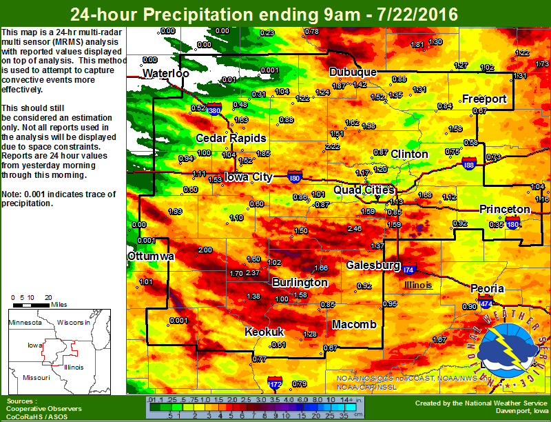
Figure 2: Local Multiple-Radar/ Multiple-Sensor 24-Rainfall |
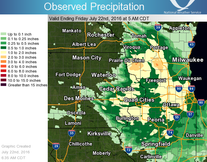
Figure 3: Regional 24-hr Rainfall |
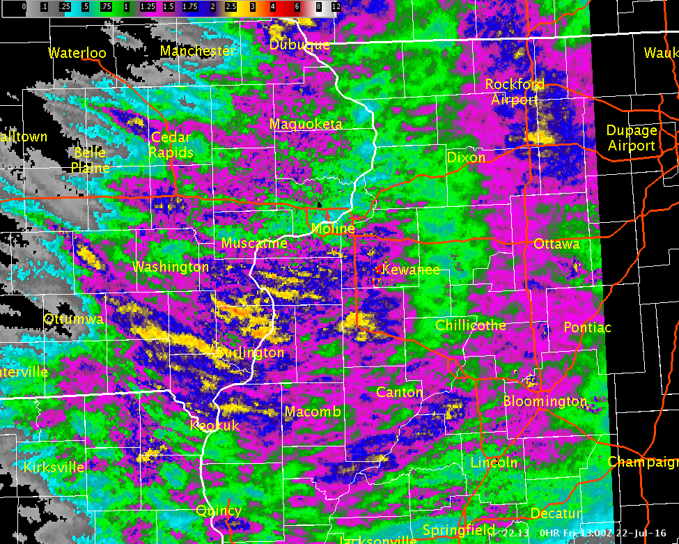
Figure 4: Multiple-Radar/ Multiple-Sensor Estimated Rainfall Ending 8 am 07/22/16 |
Public Information Statement
National Weather Service Quad Cities IA IL
833 AM CDT Fri Jul 22 2016

...24 hr Rainfall Reports...

Observations are collected from a variety of sources with varying
equipment and exposures. Not all data listed are considered official.

Location                     Amount    Time/Date       Provider
Pope Creek Near Keithsburg   2.54 in   0730 AM 07/22   USGS
Aledo                        2.46 in   0700 AM 07/22   COOP
Cedar Crk Near Oakland Mills 2.43 in   0730 AM 07/22   USGS
3 E Salem                    2.37 in   0744 AM 07/22   COCORAHS
1 NE Marion                  2.24 in   0700 AM 07/22   COCORAHS
Lowden                       2.22 in   0700 AM 07/22   COOP
1 ENE Marion                 2.00 in   0812 AM 07/22   CWOP
Fairfield                    2.00 in   0800 AM 07/22   COOP
2 NW Delmar                  1.98 in   0700 AM 07/22   COCORAHS
1 SSE Julien                 1.97 in   0817 AM 07/22   CWOP
Fairfield Arpt               1.87 in   0655 AM 07/22   AWOS
2 SSW Julien                 1.87 in   0700 AM 07/22   COCORAHS
Solon 0.3 ESE                1.85 in   0700 AM 07/22   COCORAHS
1 ESE Edmore                 1.81 in   0800 AM 07/22   HADS
Edwards Rvr At New Boston    1.77 in   0730 AM 07/22   USARMY-COE
1 NNE Olin                   1.72 in   0805 AM 07/22   CWOP
1 ESE Dubuque                1.71 in   0817 AM 07/22   CWOP
Salem 1 S                    1.70 in   0700 AM 07/22   COOP
1 NW Geneseo                 1.68 in   0500 AM 07/22   COCORAHS
1 E Hiawatha                 1.67 in   0816 AM 07/22   CWOP
1 E Dubuque                  1.67 in   0817 AM 07/22   CWOP
Cedar Rvr Near Palo          1.65 in   0815 AM 07/22   USGS
Robins                       1.63 in   0700 AM 07/22   COCORAHS
4 W Maquoketa                1.62 in   0700 AM 07/22   COOP
Mount Pleasant               1.60 in   0700 AM 07/22   COOP
1 E Reynolds                 1.59 in   0700 AM 07/22   COCORAHS
1 WSW Spring Grove           1.58 in   0700 AM 07/22   COCORAHS
2 WSW Chadwick               1.58 in   0700 AM 07/22   COCORAHS
Geneseo                      1.57 in   1200 AM 07/22   COOP
New Boston L/d 17            1.57 in   0810 AM 07/22   USARMY-COE
1 E Dubuque                  1.53 in   0816 AM 07/22   CWOP
1 NNW Williamstown           1.53 in   0700 AM 07/22   COCORAHS
North Liberty                1.52 in   0700 AM 07/22   COCORAHS
Lost Nation                  1.51 in   0700 AM 07/22   COCORAHS
Dubuque #3                   1.50 in   0700 AM 07/22   COOP
Gladstone L/d 18             1.50 in   0800 AM 07/22   COOP
3 E Iowa City                1.47 in   0821 AM 07/22   CWOP
Ely                          1.45 in   0600 AM 07/22   COCORAHS
Ms Rvr At Keithsburg         1.43 in   0730 AM 07/22   USARMY-COE
Dubuque Arpt                 1.42 in   0653 AM 07/22   ASOS
3 ENE Bentley                1.39 in   0807 AM 07/22   CWOP
3 W Pleasant Grove           1.39 in   0616 AM 07/22   CWOP
Cedar Rvr At Cedar Bluff     1.38 in   0800 AM 07/22   USGS
Coralville                   1.38 in   0800 AM 07/22   HADS
Ms Rvr At Dubuque            1.38 in   0730 AM 07/22   USARMY-COE
Donnellson                   1.38 in   0700 AM 07/22   COOP
Alexis                       1.37 in   0730 AM 07/22   COOP
Iowa Rvr At Iowa City        1.37 in   0800 AM 07/22   USGS
Iowa Rvr At Columbus Jct     1.36 in   0800 AM 07/22   USARMY-COE
Green Rvr At Geneseo         1.35 in   0730 AM 07/22   USGS
Elizabeth                    1.31 in   0630 AM 07/22   COOP
Davis                        1.31 in   0645 AM 07/22   COCORAHS
Henderson Crk At Oquawka     1.29 in   0730 AM 07/22   USGS
Bentley                      1.28 in   0645 AM 07/22   COOP
Wapsi Rvr At Oxford Jct      1.28 in   0745 AM 07/22   USGS
Cascade                      1.24 in   0700 AM 07/22   COOP
Keokuk                       1.24 in   0800 AM 07/22   COCORAHS
Monticello                   1.22 in   0720 AM 07/22   COOP
Park View                    1.20 in   0700 AM 07/22   COCORAHS
Moline                       1.20 in   0700 AM 07/22   COCORAHS
Moline                       1.15 in   0700 AM 07/22   COCORAHS
Stronghurst                  1.14 in   0823 AM 07/22   CWOP
Bellevue L/d 12              1.13 in   0800 AM 07/22   USARMY-COE
Keokuk Arpt                  1.13 in   0655 AM 07/22   AWOS
1 ESE Coal Valley            1.13 in   0700 AM 07/22   COCORAHS
2 NE Atkinson                1.12 in   0800 AM 07/22   COCORAHS
1 WSW New London             1.11 in   0700 AM 07/22   COCORAHS
Williamsburg                 1.11 in   0600 AM 07/22   COOP
Washington                   1.10 in   0700 AM 07/22   COOP
Washington Arpt              1.09 in   0655 AM 07/22   AWOS
1 NNE North Liberty          1.07 in   0817 AM 07/22   CWOP
Quad City Intl Arpt          1.07 in   0652 AM 07/22   ASOS
Skunk Rvr At Merrimac        1.05 in   0730 AM 07/22   USGS
Hoover Creak Near West Branc 1.05 in   0745 AM 07/22   USGS
Cedar Rapids Arpt            1.04 in   0652 AM 07/22   ASOS
Davenport Nws                1.04 in   0700 AM 07/22   COOP
2 SSE Buck Creek             1.04 in   0700 AM 07/22   COCORAHS
Iowa City                    1.04 in   0700 AM 07/22   COOP
La Moille                    1.04 in   0700 AM 07/22   COCORAHS
Ms Rvr At Muscatine          1.04 in   0815 AM 07/22   GOES
Mount Carroll                1.03 in   0815 AM 07/22   CWOP
New London 0.5 ESE           1.02 in   0700 AM 07/22   COCORAHS
1 WNW Oakdale                1.02 in   0700 AM 07/22   COCORAHS
1 NW Oneco                   1.02 in   0700 AM 07/22   COCORAHS
Raritan                      1.01 in   0814 AM 07/22   CWOP
Rock Rvr At Moline           1.01 in   0730 AM 07/22   USARMY-COE
2 N Muscatine                1.01 in   0700 AM 07/22   COOP
Ms Rvr Near Fort Madison     1.00 in   0730 AM 07/22   USARMY-COE
West Amana                   1.00 in   0700 AM 07/22   COCORAHS
Fort Madison 0.9 NE          1.00 in   0700 AM 07/22   COCORAHS
4 NW Monmouth                0.99 in   0800 AM 07/22   COOP
2 SSE Osborn                 0.98 in   0824 AM 07/22   CWOP
Williamsburg                 0.98 in   0819 AM 07/22   CWOP
Iowa City Arpt               0.97 in   0652 AM 07/22   ASOS
Ms Rvr At Fairport           0.96 in   0730 AM 07/22   USARMY-COE
1 WNW Eldridge               0.95 in   0809 AM 07/22   CWOP
Prairie City                 0.95 in   0600 AM 07/22   COOP
Marengo 2.6 SSW              0.94 in   0700 AM 07/22   COCORAHS
Pearl City 0.4 SW            0.94 in   0700 AM 07/22   COCORAHS
Galena Territory             0.92 in   0805 AM 07/22   CWOP
Davenport Arpt               0.92 in   0652 AM 07/22   ASOS
2 ESE Scioto Mills           0.92 in   0813 AM 07/22   CWOP
Keokuk L/d 19                0.92 in   0810 AM 07/22   USARMY-COE
2 SW Hiawatha                0.92 in   0700 AM 07/22   COCORAHS
Roseville                    0.92 in   0700 AM 07/22   COCORAHS
1 E Kewanee                  0.92 in   0700 AM 07/22   COOP
3 NNW Ely                    0.90 in   0815 AM 07/22   CWOP
Farmington                   0.90 in   0807 AM 07/22   RAWS
Coralville Dam               0.89 in   0800 AM 07/22   USARMY-COE
Cedar Rvr At Vinton          0.89 in   0815 AM 07/22   USGS
Midway                       0.88 in   0815 AM 07/22   CWOP
Galena                       0.88 in   0700 AM 07/22   COOP
De Witt                      0.87 in   0800 AM 07/22   COOP
Wapsi Rvr At Dewitt          0.85 in   0730 AM 07/22   USGS
1 WNW Freeport               0.85 in   0700 AM 07/22   COCORAHS
La Harpe                     0.85 in   0800 AM 07/22   COOP
Burlington                   0.84 in   0715 AM 07/22   COCORAHS
2 NE Cedar Rapids            0.84 in   0600 AM 07/22   COCORAHS
Williamsburg                 0.83 in   0817 AM 07/22   CWOP
Ms Rvr At Burlington         0.79 in   0800 AM 07/22   USARMY-COE
Freeport                     0.76 in   0730 AM 07/22   COOP
1 ESE Freeport               0.76 in   0700 AM 07/22   COCORAHS
Illinois City L/d 16         0.75 in   0800 AM 07/22   COOP
2 SSW Malvern                0.75 in   0700 AM 07/22   COCORAHS
1 ENE Oak Grove              0.73 in   0818 AM 07/22   CWOP
Rock Falls                   0.73 in   0700 AM 07/22   COOP
Iowa Rvr At Wapello          0.73 in   0800 AM 07/22   USGS
2 ENE Argyle Lake State      0.70 in   0700 AM 07/22   COCORAHS
Augusta                      0.67 in   0528 AM 07/22   COOP
Shannon                      0.67 in   0700 AM 07/22   COCORAHS
1 NE Sterling                0.65 in   0819 AM 07/22   CWOP
Macomb                       0.64 in   0700 AM 07/22   COOP
Duck Crk Near West Lake      0.63 in   0815 AM 07/22   USGS
Macomb                       0.62 in   0742 AM 07/22   COCORAHS
Rock Rvr Near Joslin         0.61 in   0730 AM 07/22   USGS
Rock Island L/d 15           0.61 in   0800 AM 07/22   COOP
4 N Haskins                  0.60 in   0700 AM 07/22   COCORAHS
North English                0.60 in   0700 AM 07/22   COOP
Center Point                 0.59 in   0600 AM 07/22   COCORAHS
Keosauqua                    0.58 in   0815 AM 07/22   COOP
1 NNE Credit Island          0.55 in   0530 AM 07/22   COCORAHS
Le Claire L/d 14             0.55 in   0800 AM 07/22   COOP
Macomb Arpt                  0.54 in   0655 AM 07/22   AWOS
Walnut                       0.53 in   0818 AM 07/22   CWOP
Unionville                   0.53 in   0816 AM 07/22   CWOP
1 W Riverdale                0.52 in   0824 AM 07/22   CWOP
Vinton                       0.52 in   0700 AM 07/22   COOP
Garrison                     0.51 in   0752 AM 07/22   CWOP
Cedar Rvr At Conesville      0.50 in   0800 AM 07/22   USGS
Clinton                      0.50 in   0700 AM 07/22   COCORAHS
Fulton                       0.50 in   0600 AM 07/22   COCORAHS
Urbana                       0.48 in   0814 AM 07/22   CWOP
3 NNE Lafayette              0.48 in   0630 AM 07/22   COCORAHS
Riverdale                    0.47 in   0630 AM 07/22   COCORAHS
Iowa Rvr At Marengo          0.47 in   0800 AM 07/22   USGS
1 S Princeton                0.45 in   0700 AM 07/22   COCORAHS
English Rvr Near Parnell     0.45 in   0800 AM 07/22   USGS
1 SE Princeton               0.43 in   0700 AM 07/22   COCORAHS
Princeton                    0.43 in   0700 AM 07/22   COOP
Wayland                      0.41 in   0730 AM 07/22   HADS
Big Bear Creek At Ladora     0.39 in   0800 AM 07/22   USGS
Coggon                       0.31 in   0630 AM 07/22   COOP
Environment
| SPC Event Wrap-up - July 21, 2016 | ||
 |
 |
 |
| Figure 1: 0800 AM SPC Convective Outlook |
Figure 2: 0800 AM SPC Hail Outlook |
Figure 3: 0800 AM SPC Wind Outlook |
 |
 |
 |
| Figure 4: MSAS Sfc Temps |
Figure 5: MSAS Sfc Dewpoints |
Figure 6: DVN 7/22 00z Sounding |
 |
||
| Figure 7: IR Satellite Loop |
||
 |
Media use of NWS Web News Stories is encouraged! Please acknowledge the NWS as the source of any news information accessed from this site. |
|