Dangerous and extreme heat will remain across portions of the central U.S. this week, persisting across the mid to lower Mississippi Valley, Gulf Coast, southern Plains and portions of Texas. A heat wave over the Southwest U.S. will peak this weekend. Heavy to excessive rainfall may produce flash flooding from the Delmarva Peninsula north into the Hudson Valley today and tonight. Read More >
Overview
|
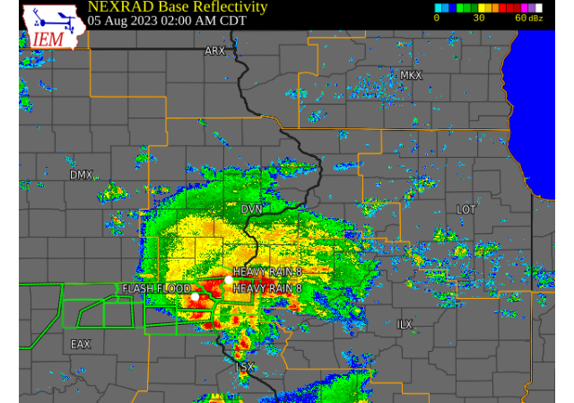
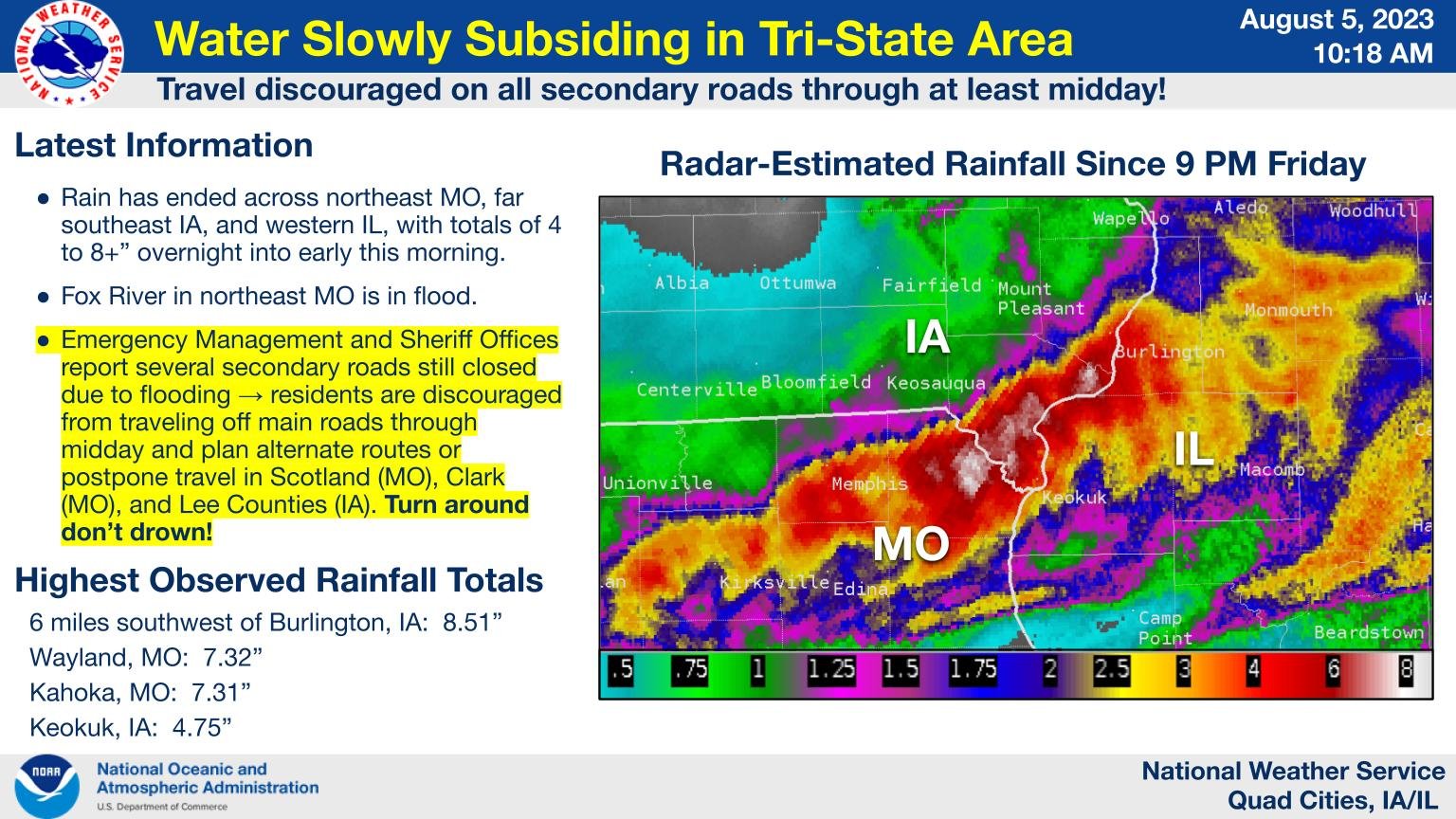
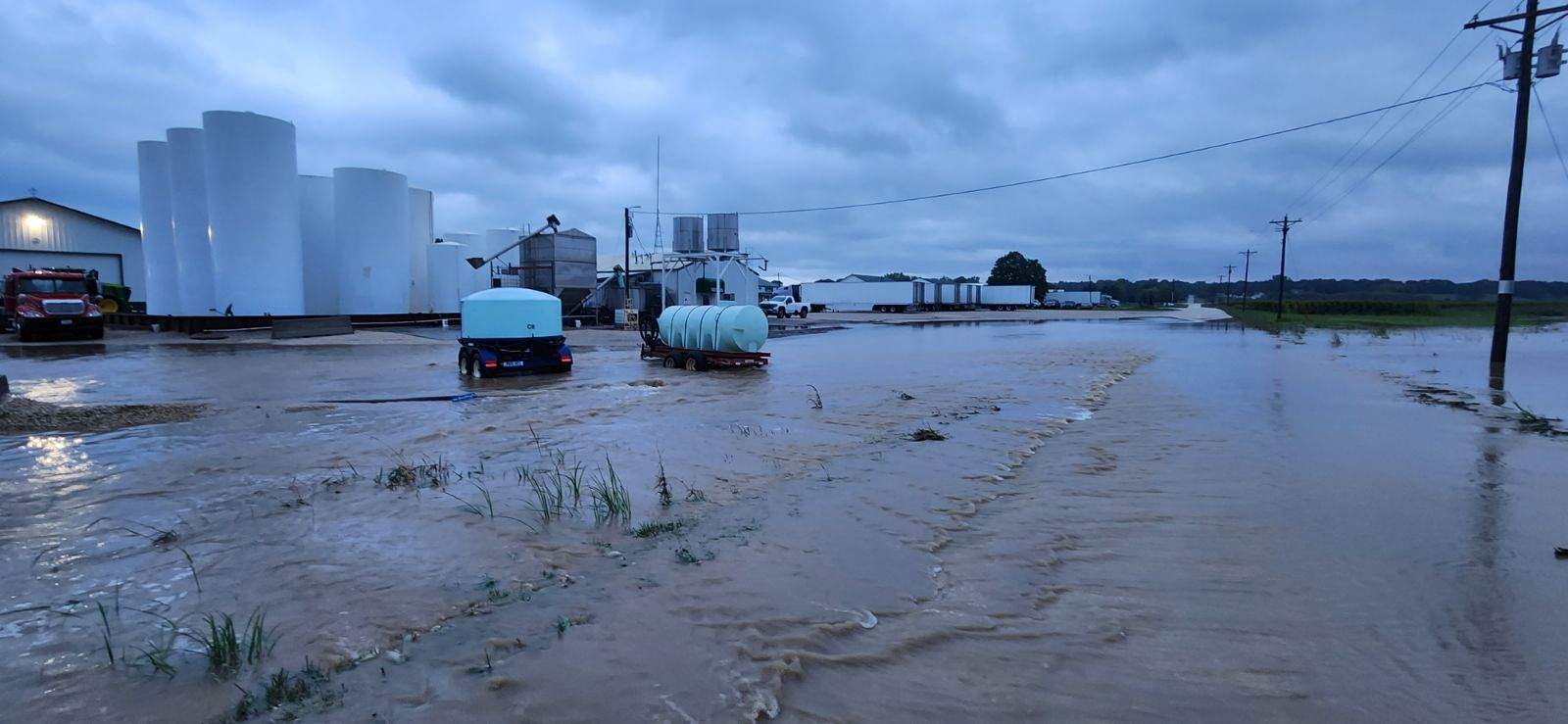
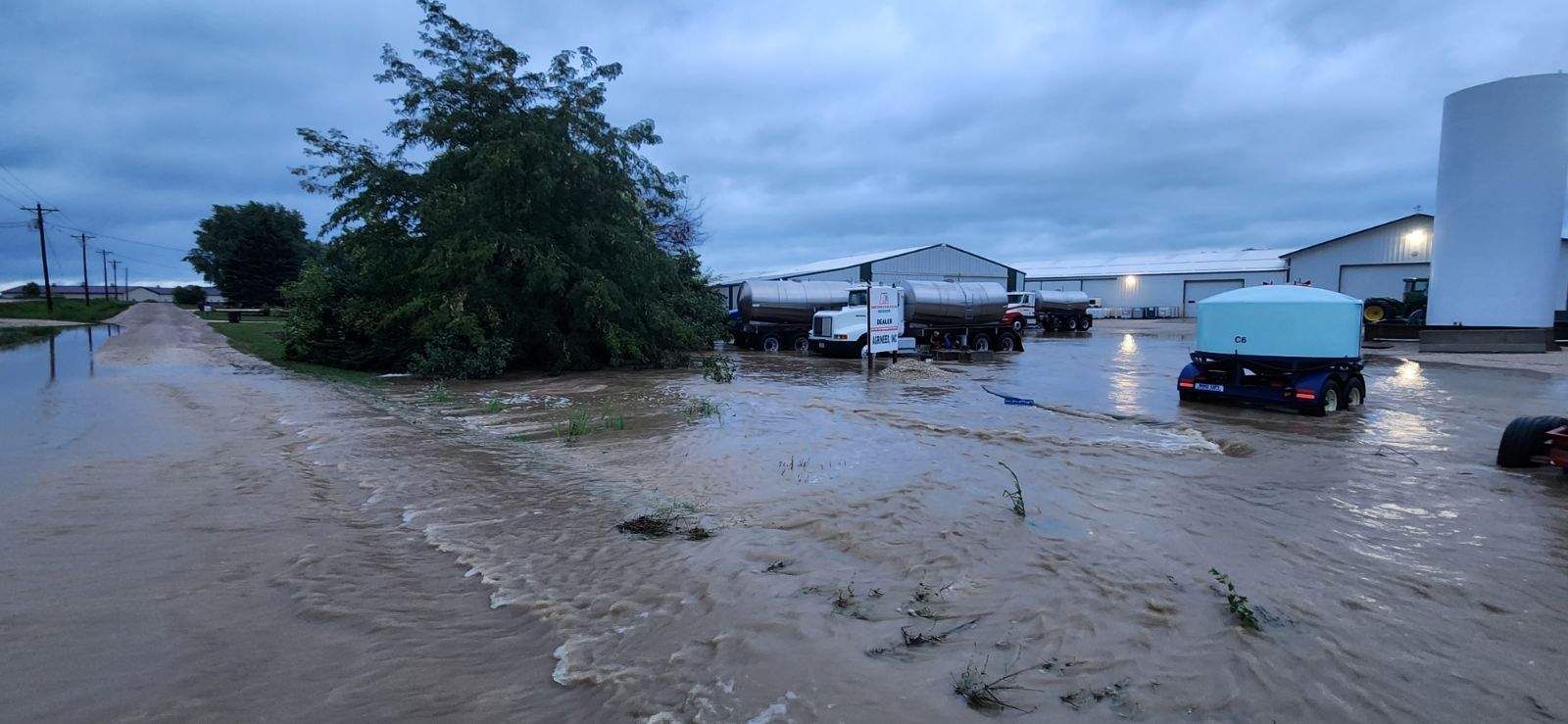
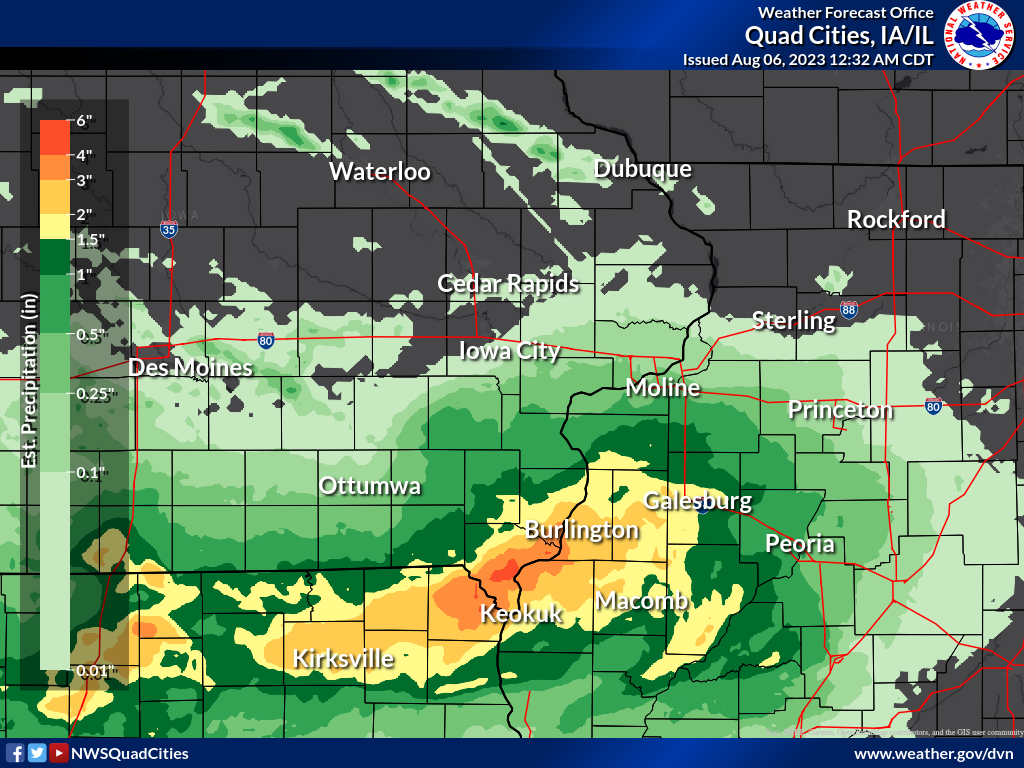
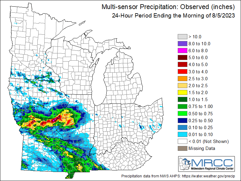
A significant rain event occurred late Friday into Saturday across northeast Missouri, extreme southeast Iowa, and west central Illinois which resulted in flash flooding and a rapid rise on the Fox River near Wayland, Missouri. A slow moving mesoscale convective vortex (MCV) tracked over the area and brought very heavy rain in a short amount of time. Rainfall amounts between 4 and 8 inches fell in less than 6 hours which caused many stalled vehicles and several water rescues in the towns of Kahoka, Missouri and Keokuk, Iowa. A culvert was washed out south of Kahoka and many secondary roads had water over them. Other towns that received heavy rain were Fort Madison, Iowa and Burlington, Iowa. |
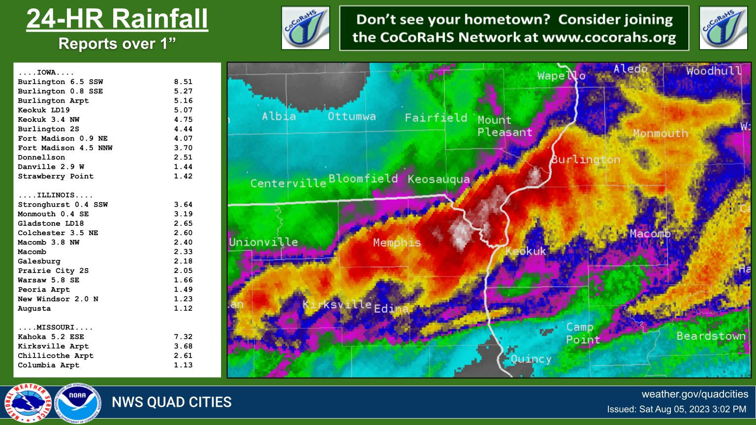 Highest Rainfall Reports with Radar Estimates from Aug 5th Yellow ~ 2.5" or Greater, Red ~ 4" or Greater, White ~ 6" or Greater |
 |
 |
.gif) |
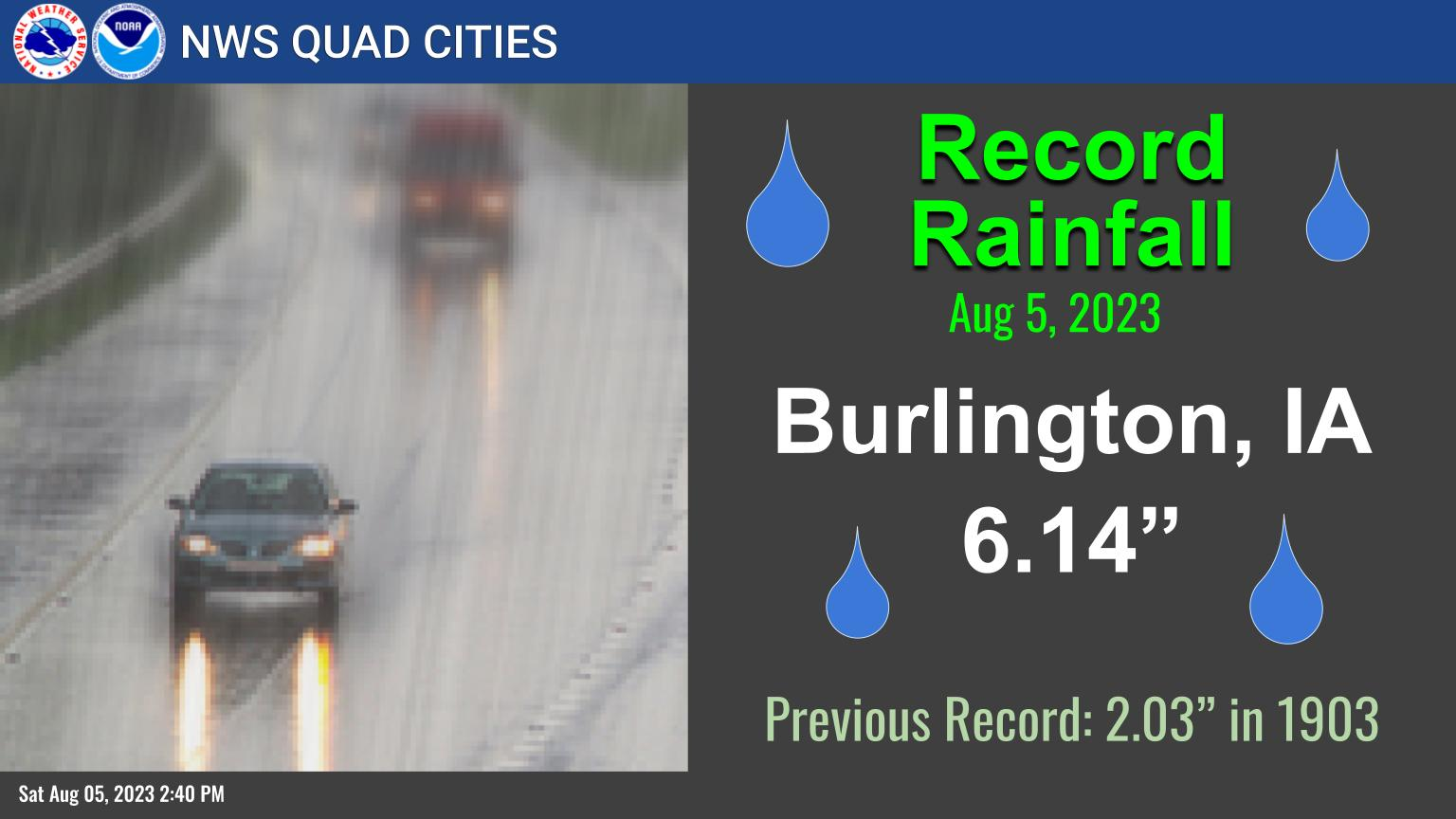
| Daily Rainfall Record - Burlington Iowa | Summary Graphic | WPC Surface Front/Pressure Analysis at 06z 08/05 |
Flooding
The Fox River at Wayland, MO rose 16 ft in 12 hours early Saturday morning. It crested at 17.56 ft which is above Minor Flood Stage.
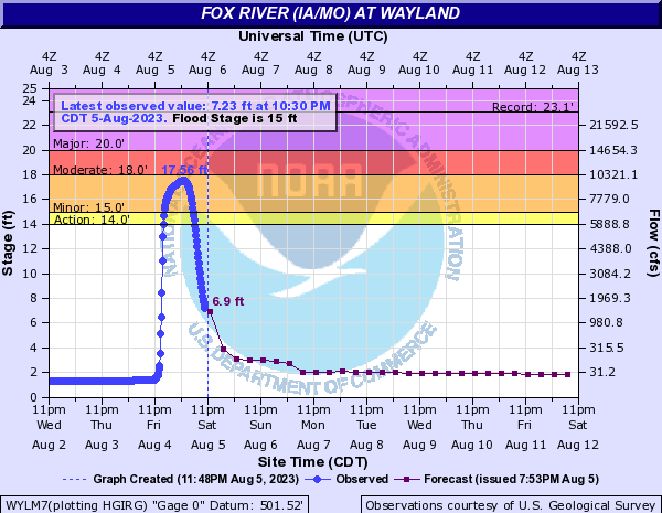 |
| Fox River At Wayland, MO Hydrograph |
Photos & Video
 |
 |
 |
 |
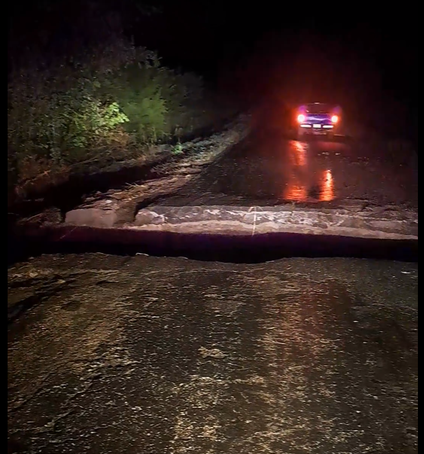
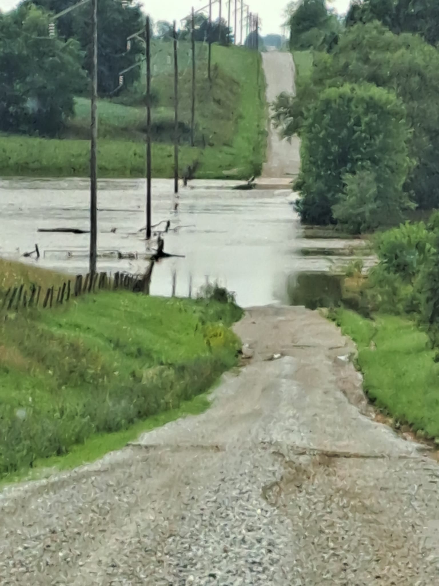
| CR Y near Rt 81 (Clark County Sheriff Dept) |
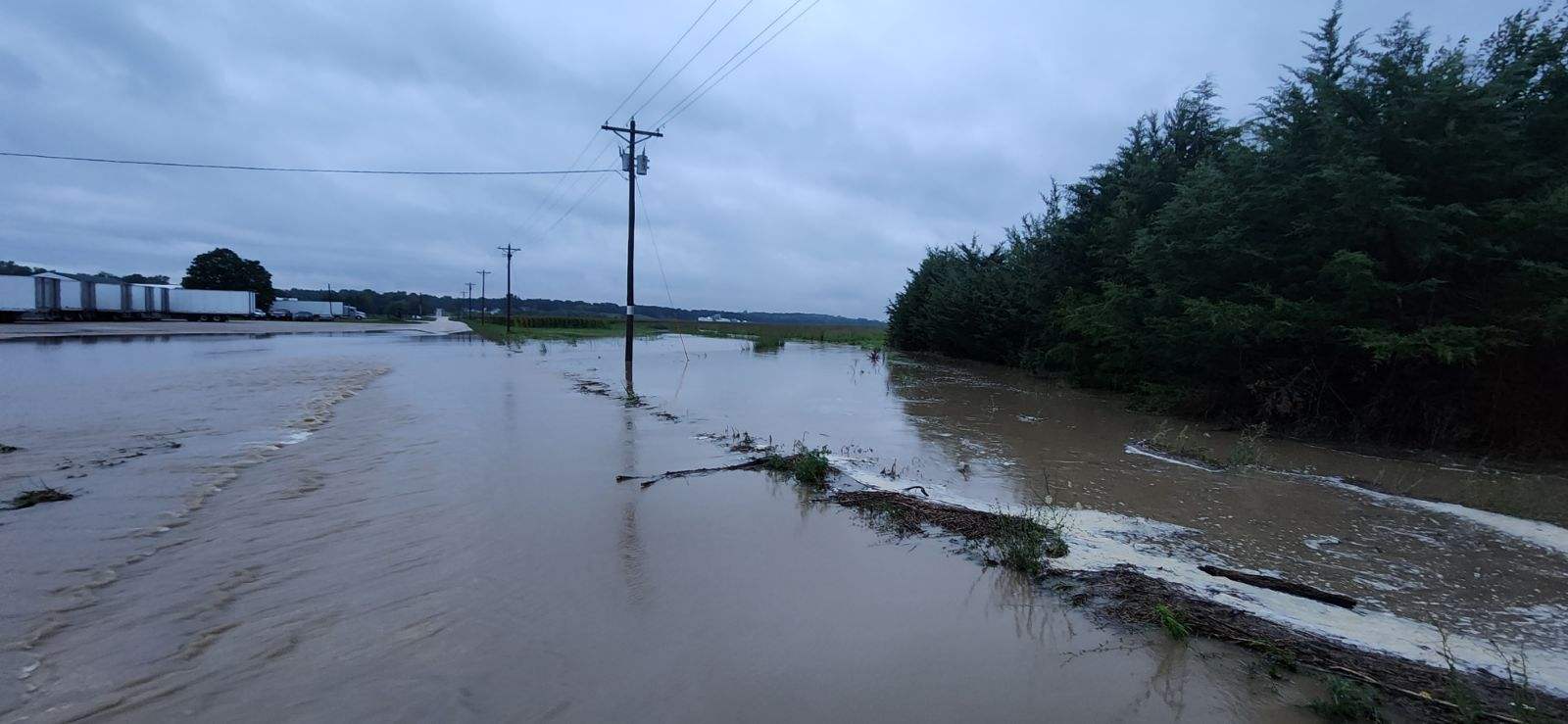
Wever, IA (Des Moines County EMA) |
Wever, IA (Des Moines County EMA) |
Wever, IA (Des Moines County EMA) |
 |
|||
| CR 163 South of Kahoka, MO (Clark County Sheriff Dept) |
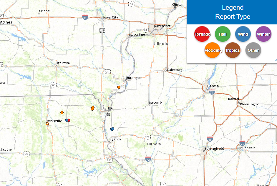
Storm Reports
| Storm Reports 8/5 |
 |
Preliminary Local Storm Report...Summary
National Weather Service Quad Cities IA IL
1254 PM CDT Sat Aug 5 2023

..TIME...   ...EVENT...      ...CITY LOCATION...     ...LAT.LON...
..DATE...   ....MAG....      ..COUNTY LOCATION..ST.. ...SOURCE....
            ..REMARKS..

1230 AM     Flash Flood      Kahoka                  40.42N 91.72W
08/05/2023                   Clark              MO   Law Enforcement

            Several streets are under water in town near
            Hwy 81 and West Cedar St.

0200 AM     Flash Flood      Kahoka                  40.42N 91.72W
08/05/2023                   Clark              MO   Law Enforcement

            Four stalled vehicles reported in town and 1
            water rescue was needed east of Kahoka on
            County Rd 182 southeast of town.

0217 AM     Non-Tstm Wnd Dmg 2 S Warsaw              40.32N 91.43W
08/05/2023                   Hancock            IL   Storm Chaser

            Several 2-4 inch diameter tree limbs down
            over road south of town, time estimated from
            radar.

0244 AM     Tstm Wnd Gst     Keokuk                  40.41N 91.41W
08/05/2023  E55 MPH          Lee                IA   Trained Spotter


0300 AM     Non-Tstm Wnd Dmg Keokuk                  40.41N 91.40W
08/05/2023                   Lee                IA   Emergency Mngr

            Several limbs blown down. Time estimated.

0315 AM     Flash Flood      Keokuk                  40.41N 91.40W
08/05/2023                   Lee                IA   Law Enforcement

            Several stalled vehicles and water rescues
            done by first responders in town in the past
            2-3 hrs. 4-5 feet of water reported on many
            roads and streets.

0330 AM     Flash Flood      2 SSW Kahoka            40.40N 91.73W
08/05/2023                   Clark              MO   Law Enforcement

            Time estimated. Culvert washed out on County
            Y west of Highway 81 and just south of the
            lake. Washout discovered by sheriff office
            between 4 and 5 AM.

0630 AM     Flash Flood      1 SW Wever              40.71N 91.24W
08/05/2023                   Lee                IA   Emergency Mngr

            EM reports drainage ditch out of its banks
            causing flooding. Time is when the pictures
            were taken.

0849 AM     Rain             2 NNW Keokuk            40.43N 91.42W
08/05/2023  M11.00 inch      Lee                IA   Public


0700 AM     Rain             2 WSW Spring Grove      40.73N 91.19W
08/05/2023  M8.51 inch       Des Moines         IA   Cocorahs

            Cocorahs station IA-DM-7 Burlington 6.5 SSW.

0200 AM     Rain             3 ENE Fort Madison      40.63N 91.30W
08/05/2023  M8.00 inch       Lee                IA   Public


0852 AM     Rain             1 SSW Burlington        40.80N 91.13W
08/05/2023  M8.00 inch       Des Moines         IA   Public


0445 AM     Rain             1 W Wever               40.72N 91.25W
08/05/2023  M7.94 inch       Lee                IA   Public


0800 AM     Rain             3 W Wayland             40.39N 91.63W
08/05/2023  M7.32 inch       Clark              MO   Cocorahs

            Cocorahs station MO-CK-4 2 W Wayland.

0950 AM     Rain             3 WSW Wayland           40.38N 91.63W
08/05/2023  M7.31 inch       Clark              MO   Mesonet

            Mesonet station GW0701 Kahoka.

0500 AM     Rain             2 NW Niota              40.64N 91.30W
08/05/2023  M7.00 inch       Lee                IA   Public


0700 AM     Rain             1 NW Burlington         40.82N 91.13W
08/05/2023  M6.50 inch       Des Moines         IA   Public


1033 AM     Rain             3 NE New Boston         40.60N 91.48W
08/05/2023  E6.50 inch       Lee                IA   Public


1147 AM     Rain             1 S Burlington          40.80N 91.12W
08/05/2023  M6.50 inch       Des Moines         IA   Public


0600 AM     Rain             1 ENE Burlington        40.81N 91.10W
08/05/2023  M6.14 inch       Des Moines         IA   Public


0900 AM     Rain             Burlington Regional Air 40.77N 91.13W
08/05/2023  M6.14 inch       Des Moines         IA   ASOS

            ASOS station KBRL Burlington Arpt.

0400 AM     Rain             1 SW Burlington         40.80N 91.14W
08/05/2023  U6.00 inch       Des Moines         IA   Public

            6 inch rain gage overtopped.

0700 AM     Rain             1 S Burlington          40.80N 91.12W
08/05/2023  E6.00 inch       Des Moines         IA   Public


0237 AM     Rain             3 WSW Wayland           40.38N 91.63W
08/05/2023  M5.82 inch       Clark              MO   Mesonet

            Rainfall in past 3 hours.

0844 AM     Rain             1 ENE Burlington Region 40.79N 91.11W
08/05/2023  M5.30 inch       Des Moines         IA   Public


0703 AM     Rain             1 SSE Burlington        40.80N 91.11W
08/05/2023  M5.27 inch       Des Moines         IA   Cocorahs

            Cocorahs station IA-DM-8 Burlington 0.8 SSE.

0500 AM     Rain             Nauvoo                  40.55N 91.39W
08/05/2023  M5.00 inch       Hancock            IL   Public


0630 AM     Rain             1 W Gulfport            40.81N 91.10W
08/05/2023  E5.00 inch       Des Moines         IA   Public


0730 AM     Rain             2 NE Wever              40.74N 91.21W
08/05/2023  M5.00 inch       Des Moines         IA   Public


1000 AM     Rain             1 ENE Burlington Region 40.79N 91.11W
08/05/2023  U5.00 inch       Des Moines         IA   Public

            5 inch rain gage was overtopped. So, more
            than 5 inches of rain fell overnight.

0600 AM     Rain             1 SSW Mooar             40.44N 91.45W
08/05/2023  M4.75 inch       Lee                IA   Cocorahs

            Cocorahs station IA-LE-16 Keokuk 3.4 NW.

0754 AM     Rain             1 SSW Mooar             40.44N 91.45W
08/05/2023  M4.75 inch       Lee                IA   Trained Spotter

            Overnight storm total.

0600 AM     Rain             1 ESE Burlington Region 40.77N 91.12W
08/05/2023  M4.44 inch       Des Moines         IA   CO-OP Observer

            CO-OP Observer station BLGI4 Burlington 2s.

0600 AM     Rain             2 NNE Colusa            40.59N 91.15W
08/05/2023  M4.28 inch       Hancock            IL   Cocorahs

            Cocorahs station IL-HN-1 Dallas City 3.0
            SSE.

0600 AM     Rain             2 NE Colusa             40.59N 91.15W
08/05/2023  M4.28 inch       Hancock            IL   Public


0335 AM     Rain             1 SSE Fort Madison Muni 40.66N 91.33W
08/05/2023  M4.17 inch       Lee                IA   AWOS

            Rainfall in the past 2h 40 min.

0900 AM     Rain             1 ENE Burlington        40.82N 91.10W
08/05/2023  M4.09 inch       Des Moines         IA   Mesonet

            Mesonet station BRLI4 Mississippi River.

0700 AM     Rain             1 NE Fort Madison       40.63N 91.34W
08/05/2023  M4.07 inch       Lee                IA   Cocorahs

            Cocorahs station IA-LE-8 Fort Madison 0.9
            NE.

0800 AM     Rain             2 SW Sawyer             40.68N 91.38W
08/05/2023  M3.70 inch       Lee                IA   Cocorahs

            Cocorahs station IA-LE-20 Fort Madison 4.5
            NNW.

0700 AM     Rain             1 SW Stronghurst        40.74N 90.91W
08/05/2023  M3.64 inch       Henderson          IL   Cocorahs

            Cocorahs station IL-HD-1 Stronghurst 0.4
            SSW.

0844 AM     Rain             5 SE Sperry             40.89N 91.10W
08/05/2023  M3.50 inch       Des Moines         IA   Public


0700 AM     Rain             1 WSW Memphis           40.46N 92.18W
08/05/2023  M3.41 inch       Scotland           MO   CO-OP Observer

            CO-OP Observer station MMPM7 Memphis.

0800 AM     Rain             1 WSW Memphis           40.46N 92.18W
08/05/2023  M3.41 inch       Scotland           MO   CO-OP Observer


0340 AM     Rain             2 ESE Keokuk            40.40N 91.37W
08/05/2023  M3.38 inch       Lee                IA   Mesonet

            Rain fall in past 2 hr 50 min, reported at
            Keokuk LD 19.

0740 AM     Rain             Monmouth                40.91N 90.64W
08/05/2023  M3.19 inch       Warren             IL   Cocorahs

            Cocorahs station IL-WR-7 Monmouth, IL.

0945 AM     Rain             1 NNE Monmouth          40.93N 90.63W
08/05/2023  M2.66 inch       Warren             IL   Mesonet

            Mesonet station GW0055 Monmouth.

0700 AM     Rain             3 W Macomb              40.46N 90.75W
08/05/2023  M2.60 inch       McDonough          IL   Cocorahs

            Cocorahs station IL-MCD-7 Colchester 3.5 NE.

0944 AM     Rain             1 SW Stronghurst        40.74N 90.91W
08/05/2023  M2.55 inch       Henderson          IL   Mesonet

            Mesonet station CW6338 Stronghurst.

0700 AM     Rain             Donnellson              40.65N 91.56W
08/05/2023  M2.51 inch       Lee                IA   CO-OP Observer

            CO-OP Observer station DNNI4 Donnellson.

0945 AM     Rain             Macomb                  40.47N 90.69W
08/05/2023  M2.48 inch       McDonough          IL   Mesonet

            Mesonet station FW6552 Macomb.

0728 AM     Rain             3 SSE Sciota            40.52N 90.72W
08/05/2023  M2.40 inch       McDonough          IL   Cocorahs

            Cocorahs station IL-MCD-6 Macomb 3.8 NW.

0700 AM     Rain             1 NE Macomb             40.48N 90.67W
08/05/2023  M2.33 inch       McDonough          IL   CO-OP Observer

            CO-OP Observer station MQBI2 Macomb.

0949 AM     Rain             4 NNW Bluff Park        40.58N 91.42W
08/05/2023  M2.21 inch       Lee                IA   Mesonet

            Mesonet station FPMMC 3 NW Nauvoo.

0935 AM     Rain             Macomb Municipal Arpt   40.52N 90.65W
08/05/2023  M2.12 inch       McDonough          IL   AWOS

            AWOS station KMQB Macomb Arpt.

0600 AM     Rain             2 S Prairie City        40.59N 90.46W
08/05/2023  M2.05 inch       McDonough          IL   CO-OP Observer

            CO-OP Observer station PRCI2 2.0 S Prairie
            City.

0930 AM     Rain             7 S Kingston            40.88N 91.03W
08/05/2023  M1.68 inch       Des Moines         IA   Mesonet

            Mesonet station GLDI2 3.6 N Lone Tree.

0630 AM     Rain             1 WNW Sutter            40.29N 91.36W
08/05/2023  M1.66 inch       Hancock            IL   Cocorahs

            Cocorahs station IL-HN-2 Warsaw 5.8 SE.

0945 AM     Rain             Macomb                  40.47N 90.68W
08/05/2023  M1.45 inch       McDonough          IL   Mesonet

            Mesonet station GW0708 Macomb.

0700 AM     Rain             3 W Danville            40.86N 91.37W
08/05/2023  M1.44 inch       Des Moines         IA   Cocorahs

            Cocorahs station IA-DM-18 Danville 2.9 W.

0930 AM     Rain             1 SSW Bald Bluff        41.00N 90.85W
08/05/2023  M1.39 inch       Henderson          IL   Mesonet

            Mesonet station OQUI2 Henderson River.

0930 AM     Rain             1 NW Niota              40.63N 91.30W
08/05/2023  M1.26 inch       Hancock            IL   Mesonet

            Mesonet station FMDI4 1.0 NW Niota.

0500 AM     Rain             Augusta                 40.23N 90.95W
08/05/2023  M1.12 inch       Hancock            IL   CO-OP Observer

            CO-OP Observer station AUGI2 Augusta.
Rain Reports
| Local Rainfall Map | MRCC Regional Rainfall Map |
 |
 |
24 hour precipitation reports (in Inches), for eastern Iowa, northwest and west central Illinois, and northeast Missouri. Reported between Midnight and 9 AM, Saturday August 05, 2023. ....IOWA.... Burlington 6.5 SSW 8.51 Burlington 0.8 SSE 5.27 Burlington Arpt 5.16 Keokuk LD19 5.07 Keokuk 3.4 NW 4.75 Burlington 2S 4.44 Fort Madison 0.9 NE 4.07 Fort Madison 4.5 NNW 3.70 Donnellson 2.51 Danville 2.9 W 1.44 Strawberry Point 1.42 Dyersville 1.7 ESE 0.89 New London 1.5 SW 0.85 Hillsboro 5.8 SE 0.67 Farmington 3.5 W 0.67 Farmington 2.4 W 0.66 Morning Sun 1.7 E 0.66 Salem 1S 0.66 Farmington 0.3 NW 0.65 Farmington 0.4 NNW 0.64 Wapello 5.4 SE 0.63 Yarmouth 1.9 SW 0.61 Wapello 0.2 S 0.60 Columbus Jct 2 SSW 0.60 Washington 5.8 SW 0.52 Fairfield 5.7 NNE 0.45 Washington 0.45 Muscatine 2.6 NNE 0.43 Wellman 4.0 E 0.40 Centerville 0 NE 0.40 Muscatine 2.1 N 0.39 Muscatine 1.7 N 0.38 Rathbun Reservoir 2 N 0.36 Muscatine 3.0 NE 0.35 Muscatine 2N 0.33 Grinnell AWOS 2 SSW 0.32 Ainsworth 7.4 N 0.28 Hampton 1 N 0.23 Davenport 0.9 WNW 0.20 Davenport 2.1 N 0.18 Davenport 1.0 NE 0.16 Davenport Arpt 0.14 Mason City 1 NNE 0.13 Iowa City 0.10 NWS Johnston* 5 NNW 0.08 Mason City ASOS 6 W 0.07 Tipton 0.3 ESE 0.04 Ely 2.0 N 0.03 Ottumwa ASOS 6 NNW 0.03 Cedar Rapids 3.3 WNW 0.02 Cedar Rapids Arpt 0.02 Marengo 3.6 N 0.01 Lowden 0.01 Camanche 1.2 W 0.00 Charlotte 1.9 WNW 0.00 Solon 0.4 WNW 0.00 Dubuque 1.4 WNW 0.00 Fayette 1 NW 0.00 Iowa City Arpt 0.00 Sigourney 0.00 Boone 1 SSW 0.00 North Liberty 0.7 SSW 0.00 Amana 4.7 W 0.00 Parnell 0.1 SSW 0.00 Marion 0.4 NNW 0.00 Lisbon 0.1 W 0.00 Robins 0.8 SE 0.00 Marion 1.7 NNW 0.00 Mount Auburn 2.2 NNW 0.00 Oelwein AWOS 0.00 Guttenberg Dam 10 0.00 Elkader 6SSW 0.00 Perry 0 W 0.00 Pella 4 N 0.00 Pella AWOS 2 WSW 0.00 Waterloo ASOS 5 NW 0.00 Oskaloosa AWOS 9 ESE 0.00 Bellevue LD12 0.00 Ames US 30 2 SSE 0.00 Marshalltown ASOS 4 N 0.00 Belle Plaine 0.00 Anamosa 3 SSW 0.00 Dubuque LD11 0.00 Williamsburg 0.00 Dubuque Arpt 0.00 ....ILLINOIS.... Stronghurst 0.4 SSW 3.64 Monmouth 0.4 SE 3.19 Gladstone LD18 2.65 Colchester 3.5 NE 2.60 Macomb 3.8 NW 2.40 Macomb 2.33 Galesburg 2.18 Prairie City 2S 2.05 Warsaw 5.8 SE 1.66 Peoria Arpt 1.49 New Windsor 2.0 N 1.23 Augusta 1.12 Aledo 0.84 New Boston LD17 0.72 Kewanee 1 E 0.58 Illinois City 6.7 SW 0.49 Taylor Ridge 1.1 N 0.37 McNabb 1.4 NW 0.34 Coal Valley 1.9 SE 0.34 Quad City Arpt 0.30 Moline 0.7 NNE 0.29 Elizabeth 0.29 Ill. City LD16 3 WNW 0.28 Quincy Arpt 0.22 Princeton 1.1 SE 0.20 Princeton 0.20 Ottawa 4 SW 0.18 Lincoln NWS 0.11 Jacksonville Arpt 0.11 Bloomington Airport 0.09 Prophetstown 0.2 SW 0.03 Windsor 0.00 Steward 0.00 Decatur Airport 0.00 Coleta 1.4 SSW 0.00 Mount Carroll 6.8 NNW 0.00 Lena 0.3 SSE 0.00 Davis 0.5 N 0.00 East Dubuque 1.7 SE 0.00 Stockton 3.4 NNE 0.00 Freeport 0.00 Tuscola 0.00 St Anne 0.00 Ogden 0.00 Mundelein 0.00 Romeoville 0.00 Rockford Arpt 0.00 Fulton LD13 0.00 Joliet Arpt 0.00 Stockton 3 NNE 0.00 Rochelle Arpt 0.00 ....MISSOURI.... Kahoka 5.2 ESE 7.32 Kirksville Arpt 3.68 Chillicothe Arpt 2.61 Columbia Arpt 1.13 |
...HIGHEST PRECIPITATION REPORTS... Location Amount Time/Date Lat/Lon Burlington 6.5 SSW 8.51 in 0700 AM 08/05 40.73N/91.19W 2 W Wayland 7.32 in 0800 AM 08/05 40.39N/91.63W Kahoka 7.31 in 0950 AM 08/05 40.38N/91.63W Burlington 0.8 SSE 5.27 in 0703 AM 08/05 40.80N/91.11W Burlington Arpt 5.16 in 0953 AM 08/05 40.77N/91.13W Keokuk 3.4 NW 4.75 in 0600 AM 08/05 40.44N/91.45W Burlington 2s 4.44 in 0600 AM 08/05 40.77N/91.12W Dallas City 3.0 SSE 4.28 in 0600 AM 08/05 40.59N/91.15W Fort Madison 0.9 NE 4.07 in 0700 AM 08/05 40.63N/91.34W Fort Madison 4.5 NNW 3.70 in 0800 AM 08/05 40.68N/91.38W Stronghurst 0.4 SSW 3.64 in 0700 AM 08/05 40.74N/90.91W Memphis 3.41 in 0700 AM 08/05 40.46N/92.18W Monmouth 3.19 in 0740 AM 08/05 40.91N/90.64W Monmouth 2.66 in 0945 AM 08/05 40.93N/90.63W Colchester 3.5 NE 2.60 in 0700 AM 08/05 40.46N/90.75W Stronghurst 2.55 in 0944 AM 08/05 40.74N/90.91W Donnellson 2.51 in 0700 AM 08/05 40.65N/91.56W Macomb 2.48 in 0945 AM 08/05 40.47N/90.69W Macomb 3.8 NW 2.40 in 0728 AM 08/05 40.52N/90.72W Macomb 2.33 in 0700 AM 08/05 40.48N/90.67W 3 NW Nauvoo 2.21 in 0949 AM 08/05 40.58N/91.42W Macomb Arpt 2.12 in 0935 AM 08/05 40.52N/90.65W 2.0 S Prairie City 2.05 in 0600 AM 08/05 40.59N/90.46W |
Environment
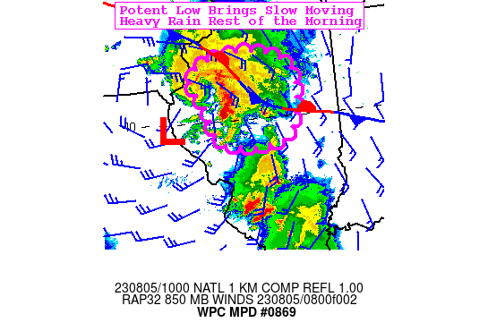
 |
 |
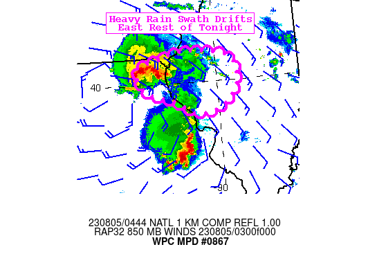 |
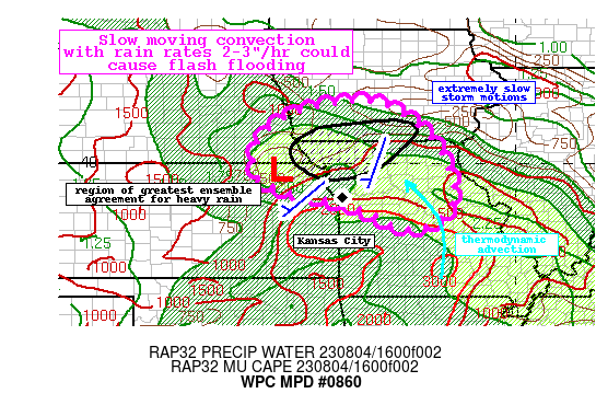
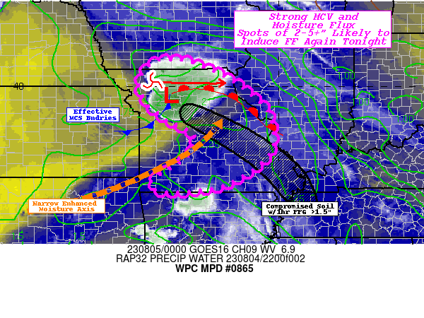
| Figure 1: Mesoscale Precipitation Discussion #860 | Figure 2: Mesoscale Precipitation Discussion #865 | Figure 3: Mesoscale Precipitation Discussion #867 |
 |
||
| Figure 4: Mesoscale Precipitation Discussion #869 |
 |
Media use of NWS Web News Stories is encouraged! Please acknowledge the NWS as the source of any news information accessed from this site. |
|