Scattered thunderstorms with severe gusts, hail and a tornado risk are possible near a cold front from the Ohio Valley to the Mid-Atlantic tonight. Tropical Storm Bertha is expected to bring tropical storm conditions to portions of the Gulf Coast from the panhandle of Florida into Louisiana through Wednesday. Read More >
Overview
|
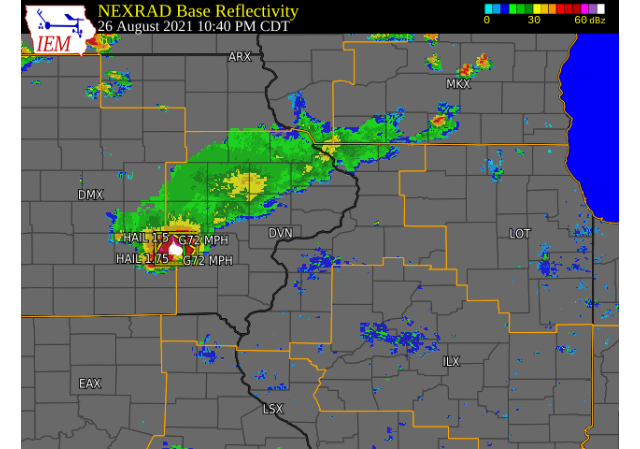
Strong storms developed late Thursday evening across north central IA and moved southeast. These storms quickly became severe and entered Keokuk county. Numerous downed trees, crop damage, and large hail were reported. The northwest portions of the county received 2+ inches of rain in a short amount of time and wind gusts between 60-70 mph were also observed. |
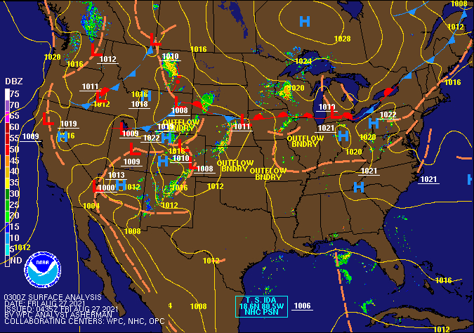
Surface Analysis Courtesy Weather Prediction Center (WPC) |
Storm Reports
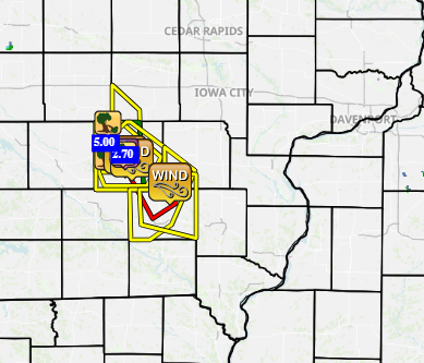
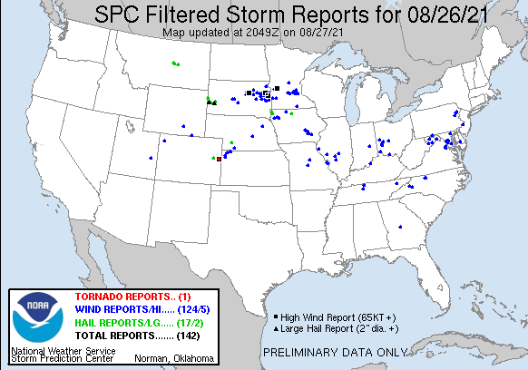
| Interactive Storm Report Map (IEM) | SPC Storm Reports |
 |
 |
PRELIMINARY LOCAL STORM REPORT...SUMMARY
NATIONAL WEATHER SERVICE QUAD CITIES IA IL
505 PM CDT FRI AUG 27 2021

..TIME...   ...EVENT...      ...CITY LOCATION...     ...LAT.LON...
..DATE...   ....MAG....      ..COUNTY LOCATION..ST.. ...SOURCE....
            ..REMARKS..

0938 PM     TSTM WND DMG     3 N THORNBURG           41.50N 92.33W
08/26/2021                   KEOKUK             IA   PUBLIC

            LARGE TREE DOWN. VIA BROADCAST MEDIA. TIME
            OF THE EVENT WAS ESTIMATED USING RADAR.

1020 PM     TSTM WND DMG     DELTA                   41.32N 92.33W
08/26/2021                   KEOKUK             IA   LAW ENFORCEMENT

            SHERIFF OFFICE REPORTS 2 TO 3 TREES DOWN
            ACROSS ROADS IN DELTA.

1025 PM     TSTM WND DMG     2 N LANCASTER           41.31N 92.16W
08/26/2021                   KEOKUK             IA   EMERGENCY MNGR

            ROOF BLOWN OFF A BARN AT EM PROPERTY. TIME
            ESTIMATED.

1030 PM     TSTM WND GST     SIGOURNEY               41.33N 92.21W
08/26/2021  M72 MPH          KEOKUK             IA   DEPT OF HIGHWAYS

            MEASURED BY IDOT RWIS.

1040 PM     TSTM WND GST     2 N LANCASTER           41.31N 92.16W
08/26/2021  M72 MPH          KEOKUK             IA   EMERGENCY MNGR

            WEATHER STATION AT EM RESIDENCE.

1047 PM     HAIL             1 WNW SIGOURNEY         41.34N 92.23W
08/26/2021  E1.00 INCH       KEOKUK             IA   CO-OP OBSERVER

            TIME ESTIMATED FROM RADAR, DELAYED REPORT.

1048 PM     HAIL             SIGOURNEY               41.33N 92.21W
08/26/2021  M1.75 INCH       KEOKUK             IA   TRAINED SPOTTER

            .

1049 PM     HAIL             2 N SIGOURNEY           41.36N 92.21W
08/26/2021  M1.50 INCH       KEOKUK             IA   TRAINED SPOTTER

            MIX OF HAIL SIZES FROM PENNIES TO PING PONG
            BALL.

1051 PM     TSTM WND DMG     SIGOURNEY               41.34N 92.22W
08/26/2021                   KEOKUK             IA   TRAINED SPOTTER

            NUMEROUS 2.5 INCH TREE LIMBS DOWN ACROSS
            TOWN WITH TWO LARGE TREES DOWN. TIME OF THE
            EVENT ESTIMATED USING RADAR.

1135 PM     TSTM WND GST     3 SE RUBIO              41.19N 91.90W
08/26/2021  E60 MPH          WASHINGTON         IA   LAW ENFORCEMENT

            MEASURED AT LAKE DARLING STATE PARK.

0754 AM     HEAVY RAIN       1 W SIGOURNEY           41.34N 92.22W
08/27/2021  M2.70 INCH       KEOKUK             IA   TRAINED SPOTTER

            RAINFALL FROM LAST EVENING.

0758 AM     HEAVY RAIN       WHAT CHEER              41.40N 92.35W
08/27/2021  E5.00 INCH       KEOKUK             IA   PUBLIC

            REPORTED 5.00 INCHES OF RAIN IN TWO HOURS.
Rainfall Reports
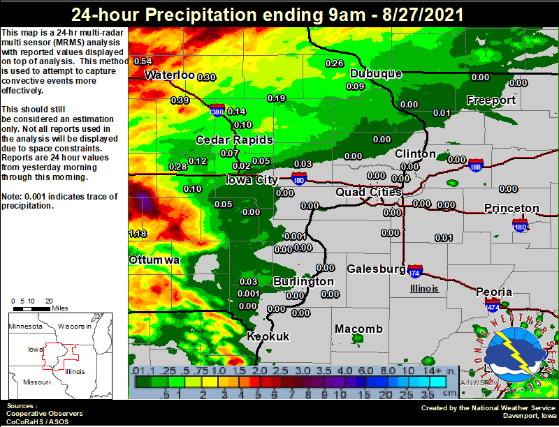 |
24 hour precipitation reports (in Inches), for eastern Iowa, northwest and west central Illinois, and northeast Missouri. Reported between Midnight and 9 AM, Friday August 27, 2021. ....IOWA.... Grinnell AWOS 2 SSW 2.22 Mason City ASOS 6 W 1.60 Oskaloosa AWOS 9 ESE 1.18 Boone 1 SSW 1.09 NWS Johnston* 5 NNW 0.93 Marshalltown ASOS 4 N 0.62 Waterloo ASOS 5 NW 0.54 Marshalltown 1 NW 0.53 Mount Auburn 2.2 NNW 0.39 Independence 0.9 WNW 0.30 Marengo 2.6 SSW 0.28 Rickardsville 0.2 W 0.26 Center Point 0.6 NNW 0.21 Hopkinton 5.4 WSW 0.19 Ely 0.5 SE 0.19 Central City 6.7 W 0.14 Amana 4.7 W 0.12 Cedar Rapids 2.7 NE 0.10 Cedar Rapids 5.2 NNE 0.10 Marion 1.7 NNW 0.10 Parnell 0.1 SSW 0.10 Pella AWOS 2 WSW 0.09 Dubuque Arpt 0.09 Cedar Rapids Arpt 0.07 Marengo 3.6 N 0.07 Wellman 4.0 E 0.05 Fairfax 4.0 NW 0.05 Solon 0.3 ESE 0.05 Asbury 0.4 SW 0.03 Tipton 0.7 N 0.03 Salem 3.1 ESE 0.03 North Liberty 0.7 SSW 0.02 West Point 7.5 NW 0.00 Wapello 0.2 S 0.00 Ottumwa ASOS 6 NNW 0.00 Iowa City Arpt 0.00 Beaconsfield 1 NNE 0.00 Muscatine 2.1 N 0.00 Wapello 5.4 SE 0.00 Burlington 6.5 SSW 0.00 Davenport 0.9 WNW 0.00 Camanche 1.2 W 0.00 Morning Sun 1.7 E 0.00 Davenport Arpt 0.00 Park View 0.2 WSW 0.00 Donnellson 0.00 Charlotte 1.9 WNW 0.00 Fort Madison 0.9 NE 0.00 Burlington Arpt 0.00 Ainsworth 7.4 N 0.00 Le Claire 1.8 NNE 0.00 Calamus 2.0 NE 0.00 West Liberty 0.7 NNW 0.00 ....ILLINOIS.... Decatur Airport 0.29 Quincy ASOS 0.16 Lincoln NWS 0.02 |
 |
Media use of NWS Web News Stories is encouraged! Please acknowledge the NWS as the source of any news information accessed from this site. |
|