Scattered thunderstorms with severe gusts, hail and a tornado risk are possible near a cold front from the Ohio Valley to the Mid-Atlantic tonight. Tropical Storm Bertha is expected to bring tropical storm conditions to portions of the Gulf Coast from the panhandle of Florida into Louisiana through Wednesday. Read More >
Overview
|
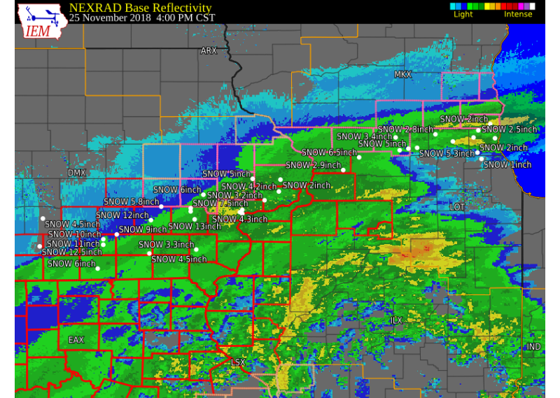
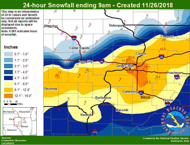
A strong area of low pressure tracked east across Kansas, Missouri, and central Illinois on Sunday, bringing heavy snowfall and gusty winds to the region. This caused blizzard conditions across much of southeast Iowa, northeast Missouri, and northwest Illinois, with zero visibility at times during the afternoon and evening. Strong north winds between 30 and 50 mph were reported during the storm. The heaviest snowfall reports between 8 and 12 inches were common from a line from Sigourney, IA, to the Quad Cities, to Sterling Illinois. A sharp cutoff of little to no snow was found on north end of storm generally in a line from the Cedar Rapids airport to Dubuque.
Surrounding Office Summaries
|
 Watch / Warning / Advisory Map |
| Video of Weather Balloon Launch Sunday Evening November 25th, 2018 | |
Maps
 |
 |
 |
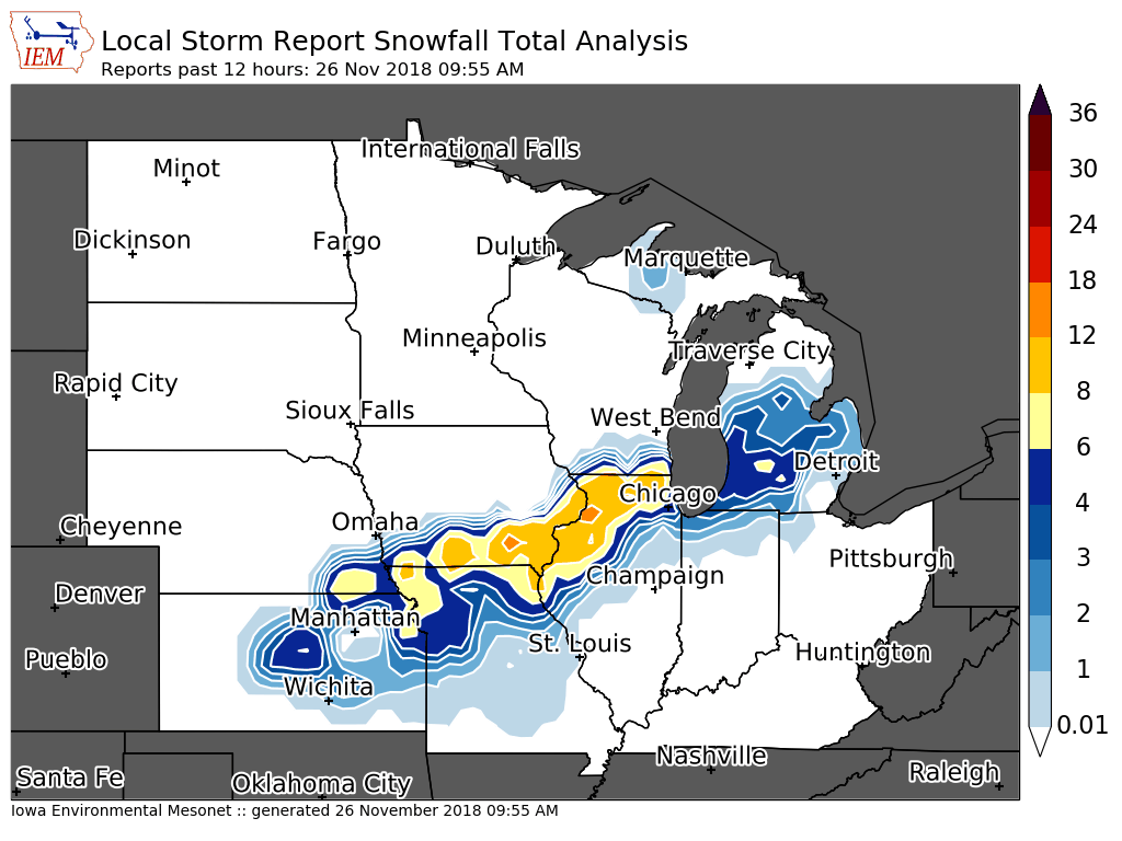
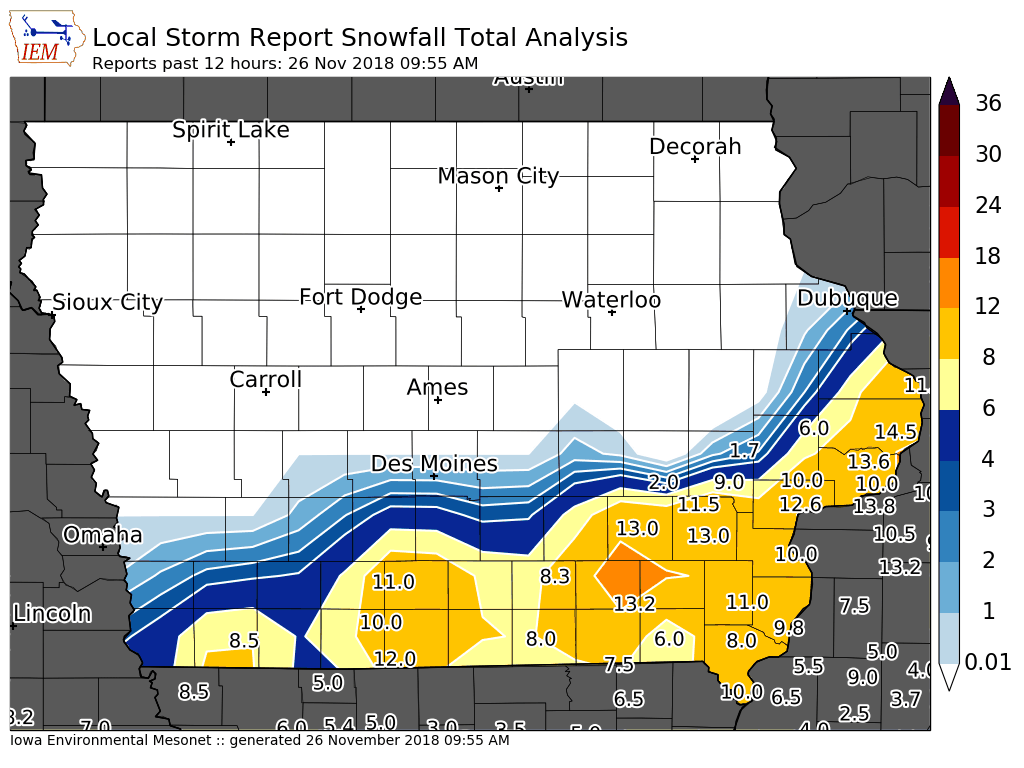
| Interactive Map Link | Midwest Snow Analysis Courtesy Iowa Environmental Mesonet |
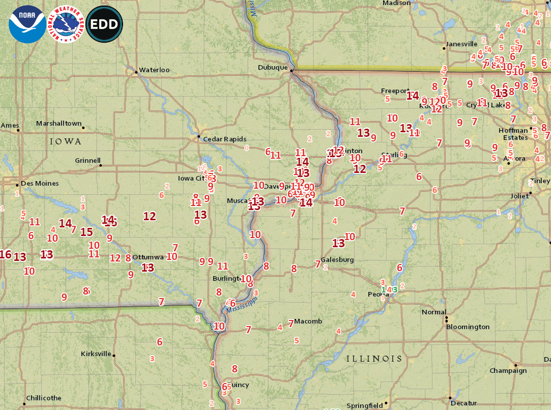
Local Snowfall ending 9 am Monday 11/26 |
 |
 |
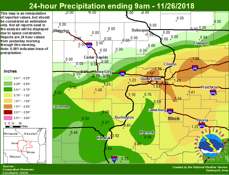 |
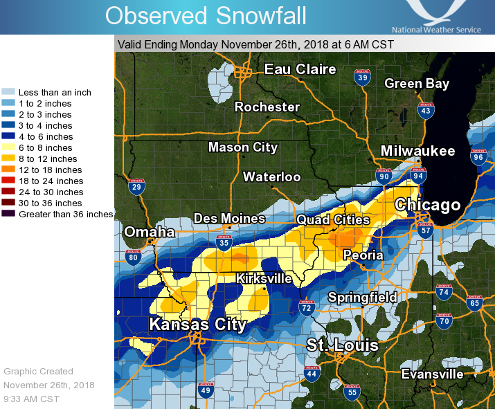
| Iowa Local Snowfall - Courtesy Iowa Environmental Mesonet | Regional Snowfall | Local Precipitation ending 9 am Monday 11/26 |
Storm Reports
|
||
| Interactive Map Link |
PRELIMINARY LOCAL STORM REPORT...SUMMARY
NATIONAL WEATHER SERVICE QUAD CITIES IA IL
956 AM CST MON NOV 26 2018
..TIME... ...EVENT... ...CITY LOCATION... ...LAT.LON...
..DATE... ....MAG.... ..COUNTY LOCATION..ST.. ...SOURCE....
..REMARKS..
1030 PM HEAVY SNOW 2 W FULTON 41.85N 90.19W
11/25/2018 E14.5 INCH CLINTON IA PUBLIC
STORM TOTAL SNOWFALL.
0600 AM HEAVY SNOW MOLINE QUAD-CITY AIRPOR 41.45N 90.50W
11/26/2018 M13.8 INCH ROCK ISLAND IL OFFICIAL NWS OBS
STORM TOTAL.
0700 AM SNOW PARK VIEW 41.69N 90.54W
11/26/2018 M13.6 INCH SCOTT IA COCORAHS
COCORAHS STATION IA-ST-3, PARK VIEW.
0500 AM SNOW 2 NW GENESEO 41.47N 90.18W
11/26/2018 M13.1 INCH HENRY IL COCORAHS
COCORAHS STATION IL-HY-8, 1 NW GENESEO.
0833 AM HEAVY SNOW GALVA 41.17N 90.04W
11/26/2018 M13.0 INCH HENRY IL TRAINED SPOTTER
STORM TOTAL.
0800 AM SNOW SIGOURNEY 41.33N 92.20W
11/26/2018 M13.0 INCH KEOKUK IA CO-OP OBSERVER
CO-OP OBSERVER STATION SGYI4, SIGOURNEY.
0733 AM HEAVY SNOW 1 SE WASHINGTON 41.29N 91.69W
11/26/2018 M13.0 INCH WASHINGTON IA PUBLIC
STORM TOTAL.
1030 PM HEAVY SNOW PARK VIEW 41.69N 90.54W
11/25/2018 M13.0 INCH SCOTT IA NWS EMPLOYEE
STORM TOTAL SNOWFALL. BLIZZARD CONDITIONS
WERE OBSERVED AT TIMES.
0110 AM HEAVY SNOW 3 NE MUSCATINE 41.46N 91.03W
11/26/2018 M12.6 INCH MUSCATINE IA PUBLIC
STORM TOTAL SNOWFALL. DRIFTS UP TO 3 FEET.
0937 AM HEAVY SNOW 1 E CAMANCHE 41.79N 90.26W
11/26/2018 M12.1 INCH CLINTON IA CO-OP OBSERVER
STORM TOTAL. NEW RECORD FOR MOST IN 24 HOUR
PERIOD.
0810 AM HEAVY SNOW 1 SSW KEWANEE 41.23N 89.93W
11/26/2018 E12.0 INCH HENRY IL TRAINED SPOTTER
STORM TOTAL.
0729 AM HEAVY SNOW 2 E COMO 41.77N 89.73W
11/26/2018 M12.0 INCH WHITESIDE IL TRAINED SPOTTER
STORM TOTAL.
0715 AM HEAVY SNOW 3 E STERLING 41.80N 89.64W
11/26/2018 M12.0 INCH WHITESIDE IL TRAINED SPOTTER
0700 AM SNOW 2 SE COAL VALLEY 41.43N 90.42W
11/26/2018 M12.0 INCH HENRY IL COCORAHS
COCORAHS STATION IL-HY-5, 1 ESE COAL VALLEY.
0530 AM SNOW 2 SSE DAVENPORT 41.53N 90.59W
11/26/2018 M12.0 INCH SCOTT IA COCORAHS
COCORAHS STATION IA-ST-4, 2 SSE DAVENPORT.
1251 AM HEAVY SNOW DAVENPORT MUNICIPALITY 41.61N 90.58W
11/26/2018 M11.9 INCH SCOTT IA OFFICIAL NWS OBS
STORM TOTAL. 6 HOUR AMOUNT 5.9 INCHES 6 PM
TO MIDNIGHT.
0905 AM HEAVY SNOW 1 NNE BETTENDORF 41.58N 90.47W
11/26/2018 M11.7 INCH SCOTT IA TRAINED SPOTTER
STORM TOTAL.
0930 AM HEAVY SNOW 1 E CLINTON 41.84N 90.22W
11/26/2018 M11.5 INCH CLINTON IA TRAINED SPOTTER
STORM TOTAL.
0630 AM SNOW 3 W RICHMOND 41.46N 91.76W
11/26/2018 M11.5 INCH WASHINGTON IA COCORAHS
COCORAHS STATION IA-WS-7, 3 W RICHMOND.
0606 AM HEAVY SNOW FULTON 41.87N 90.16W
11/26/2018 M11.5 INCH WHITESIDE IL PUBLIC
RELAYED VIA MEDIA. STORM TOTAL.
1007 PM HEAVY SNOW 3 E STERLING 41.80N 89.64W
11/25/2018 E11.2 INCH WHITESIDE IL TRAINED SPOTTER
SO FAR. STILL SNOWING.
0711 AM HEAVY SNOW 1 WNW LONG GROVE 41.70N 90.59W
11/26/2018 M11.1 INCH SCOTT IA TRAINED SPOTTER
STORM TOTAL.
0850 AM HEAVY SNOW 1 NNE FAIRFIELD 41.02N 91.96W
11/26/2018 M11.0 INCH JEFFERSON IA CO-OP OBSERVER
STORM TOTAL.
0722 AM HEAVY SNOW 1 SE DAVENPORT 41.54N 90.59W
11/26/2018 M11.0 INCH SCOTT IA TRAINED SPOTTER
STORM TOTAL.
0700 AM SNOW SHANNON 42.15N 89.74W
11/26/2018 M11.0 INCH CARROLL IL COCORAHS
COCORAHS STATION IL-CR-13, SHANNON.
0700 AM SNOW 1 NNE MOLINE 41.49N 90.48W
11/26/2018 M11.0 INCH ROCK ISLAND IL COCORAHS
COCORAHS STATION IL-RI-13, MOLINE.
0700 AM SNOW 1 SE DAVENPORT 41.54N 90.59W
11/26/2018 M11.0 INCH SCOTT IA COCORAHS
COCORAHS STATION IA-ST-37, 1 SE DAVENPORT.
0630 AM SNOW 1 ENE RIVERDALE 41.54N 90.45W
11/26/2018 M11.0 INCH SCOTT IA COCORAHS
COCORAHS STATION IA-ST-8, RIVERDALE.
0104 AM HEAVY SNOW 1 SE DAVENPORT 41.54N 90.60W
11/26/2018 M11.0 INCH SCOTT IA PUBLIC
STORM TOTAL SNOWFALL.
1145 PM HEAVY SNOW NEW LONDON 40.93N 91.41W
11/25/2018 E11.0 INCH HENRY IA PUBLIC
STORM TOTAL.
0530 AM SNOW 2 NNW DAVENPORT 41.58N 90.62W
11/26/2018 M10.7 INCH SCOTT IA COCORAHS
COCORAHS STATION IA-ST-31, 2 NNW DAVENPORT.
0500 AM HEAVY SNOW 2 NW DAVENPORT 41.58N 90.62W
11/26/2018 M10.7 INCH SCOTT IA NWS EMPLOYEE
STORM TOTAL, INCLUDES SOME SLEET. 1.25
INCHES LIQUID, SLR 9 TO 1. ALSO HAD 0.80
INCHES OF RAIN BEFORE CHANGEOVER TO SNOW FOR
2.05 INCHES OF TOTAL LIQUID.
0834 AM HEAVY SNOW 1 W CAMBRIDGE 41.30N 90.20W
11/26/2018 M10.5 INCH HENRY IL TRAINED SPOTTER
STORM TOTAL.
0700 AM SNOW 1 SSW COLETA 41.89N 89.81W
11/26/2018 M10.5 INCH WHITESIDE IL COCORAHS
COCORAHS STATION IL-WD-8, 1 SW COLETA.
0712 AM HEAVY SNOW HOOPPOLE 41.52N 89.91W
11/26/2018 M10.0 INCH HENRY IL PUBLIC
STORM TOTAL, DRIFTING SNOW FROM WIND LAST
NIGHT NO WIND THIS MORNING. ICE UNDERNEATH
FROM RAIN AT START YESTERDAY.
0700 AM SNOW 4 N HASKINS 41.40N 91.54W
11/26/2018 M10.0 INCH WASHINGTON IA COCORAHS
COCORAHS STATION IA-WS-2, 4 N HASKINS.
0654 AM HEAVY SNOW 3 WNW NEW BOSTON 41.19N 91.06W
11/26/2018 E10.0 INCH MERCER IL CO-OP OBSERVER
STORM TOTAL, MEASURED AT LOCK AND DAM 17.
0540 AM HEAVY SNOW 1 SSW MOOAR 40.44N 91.45W
11/26/2018 M10.0 INCH LEE IA TRAINED SPOTTER
STORM TOTAL.
0200 AM HEAVY SNOW 1 E WEST BURLINGTON 40.83N 91.16W
11/26/2018 E10.0 INCH DES MOINES IA TRAINED SPOTTER
STORM TOTAL ESTIMATED 10 TO 12 INCHES.
1252 AM HEAVY SNOW BETTENDORF 41.57N 90.48W
11/26/2018 E10.0 INCH SCOTT IA PUBLIC
STORM TOTAL.
1213 AM HEAVY SNOW 1 ENE MONTPELIER 41.47N 90.78W
11/26/2018 M10.0 INCH SCOTT IA TRAINED SPOTTER
STORM TOTAL.
1159 PM HEAVY SNOW 1 SW DAVENPORT 41.55N 90.61W
11/25/2018 M10.0 INCH SCOTT IA PUBLIC
STORM TOTAL SNOWFALL.
1110 PM HEAVY SNOW WILTON 41.59N 91.02W
11/25/2018 E10.0 INCH MUSCATINE IA PUBLIC
DELAYED REPORT. STORM TOTAL.
0816 AM HEAVY SNOW 1 ENE BURLINGTON REGION 40.79N 91.11W
11/26/2018 M9.8 INCH DES MOINES IA TRAINED SPOTTER
STORM TOTAL.
0701 AM HEAVY SNOW GENESEO 41.45N 90.15W
11/26/2018 M9.8 INCH HENRY IL CO-OP OBSERVER
STORM TOTAL.
0700 AM SNOW 2 N MUSCATINE 41.45N 91.07W
11/26/2018 M9.5 INCH MUSCATINE IA COCORAHS
COCORAHS STATION IA-MC-13, 2 N MUSCATINE.
0621 AM HEAVY SNOW GALVA 41.17N 90.04W
11/26/2018 M9.5 INCH HENRY IL TRAINED SPOTTER
STORM TOTAL.
0702 AM HEAVY SNOW MILLEDGEVILLE 41.97N 89.78W
11/26/2018 M9.4 INCH CARROLL IL TRAINED SPOTTER
STORM TOTAL.
0700 AM SNOW 1 ENE KEWANEE 41.25N 89.90W
11/26/2018 M9.4 INCH HENRY IL CO-OP OBSERVER
CO-OP OBSERVER STATION KEWI2, 1 E KEWANEE.
0830 AM HEAVY SNOW 1 S WALCOTT 41.58N 90.77W
11/26/2018 M9.1 INCH SCOTT IA TRAINED SPOTTER
STORM TOTAL.
0449 AM HEAVY SNOW 1 W BETTENDORF 41.57N 90.50W
11/26/2018 M9.1 INCH SCOTT IA TRAINED SPOTTER
STORM TOTAL.
0909 AM HEAVY SNOW 2 NNW BARDOLPH 40.52N 90.58W
11/26/2018 M9.0 INCH MCDONOUGH IL TRAINED SPOTTER
STORM TOTAL.
0700 AM SNOW 1 N ALEDO 41.22N 90.75W
11/26/2018 M9.0 INCH MERCER IL CO-OP OBSERVER
CO-OP OBSERVER STATION ALEI2, ALEDO.
0700 AM SNOW 1 W WASHINGTON AIRPORT 41.28N 91.68W
11/26/2018 M9.0 INCH WASHINGTON IA CO-OP OBSERVER
CO-OP OBSERVER STATION WSHI4, WASHINGTON.
1111 PM HEAVY SNOW HILLS 41.58N 91.54W
11/25/2018 E9.0 INCH JOHNSON IA PUBLIC
STORM TOTAL. SNOW HAS ENDED.
0957 PM HEAVY SNOW 1 NE DAVENPORT 41.57N 90.58W
11/25/2018 M9.0 INCH SCOTT IA PUBLIC
STORM TOTAL SNOWFALL.
0931 AM HEAVY SNOW 2 NNW WARNER 41.45N 90.40W
11/26/2018 E8.0 INCH HENRY IL TRAINED SPOTTER
STORM TOTAL 1.17 LIQUID PRECIPITATION.
0700 AM SNOW 1 S DONNELLSON 40.63N 91.57W
11/26/2018 M8.0 INCH LEE IA CO-OP OBSERVER
CO-OP OBSERVER STATION DNNI4, DONNELLSON.
0600 AM SNOW 1 NNW HAMILTON 40.40N 91.37W
11/26/2018 M8.0 INCH HANCOCK IL MESONET
MESONET STATION EOKI4, KEOKUK L/D 19.
1145 PM HEAVY SNOW WEST POINT 40.72N 91.45W
11/25/2018 E8.0 INCH LEE IA PUBLIC
STORM TOTAL.
0936 AM HEAVY SNOW 5 WNW HITT 40.59N 92.33W
11/26/2018 E7.5 INCH SCOTLAND MO PUBLIC
STORM TOTAL.
0956 PM HEAVY SNOW MONMOUTH 40.91N 90.64W
11/25/2018 E7.5 INCH WARREN IL PUBLIC
SO FAR. STILL SNOWING.
0900 AM HEAVY SNOW 1 NW BUSHNELL 40.56N 90.51W
11/26/2018 E7.0 INCH MCDONOUGH IL TRAINED SPOTTER
STORM TOTAL ESTIMATED. DIFFICULT TO MEASURE
DUE AREAS OF BARE GROUND AND DRIFTS TO 2
FEET. .46 RAINFALL TO 5 PM ON THE 25TH, THEN
1.05 PRECIPITATION 5 PM TO 9 AM TODAY.
0857 AM HEAVY SNOW 2 NE NEW WINDSOR 41.23N 90.43W
11/26/2018 M7.0 INCH HENRY IL TRAINED SPOTTER
STORM TOTAL, AVERAGE OF MULTIPLE
MEASUREMENTS DUE TO DRIFTING.
0856 AM SNOW CANTRIL 40.64N 92.07W
11/26/2018 M6.5 INCH VAN BUREN IA TRAINED SPOTTER
STORM TOTAL. SNOW ENDED 10 PM ON THE 25TH.
.60 TOTAL LIQUID PRECIPITATION.
0838 AM SNOW 6 SW MEMPHIS 40.40N 92.26W
11/26/2018 M6.5 INCH SCOTLAND MO TRAINED SPOTTER
STORM TOTAL.
0759 AM HEAVY SNOW 1 W BETTENDORF 41.56N 90.49W
11/26/2018 M6.5 INCH SCOTT IA TRAINED SPOTTER
STORM TOTAL.
0645 AM HEAVY SNOW CARTHAGE 40.41N 91.13W
11/26/2018 E6.5 INCH HANCOCK IL TRAINED SPOTTER
STORM TOTAL, LOTS OF DRIFTING.
0643 AM HEAVY SNOW 2 SSE TAYLOR RIDGE 41.36N 90.65W
11/26/2018 M6.5 INCH ROCK ISLAND IL TRAINED SPOTTER
STORM TOTAL.
1000 PM SNOW PRINCETON 41.38N 89.47W
11/25/2018 E6.5 INCH BUREAU IL PUBLIC
DELAYED REPORT. AMOUNT SO FAR. STILL
SNOWING.
0956 PM HEAVY SNOW CANTRIL 40.64N 92.07W
11/25/2018 E6.5 INCH VAN BUREN IA TRAINED SPOTTER
0642 AM HEAVY SNOW 3 ENE FORT MADISON 40.63N 91.30W
11/26/2018 E6.3 INCH LEE IA TRAINED SPOTTER
STORM TOTAL.
0941 AM HEAVY SNOW 2 SE CARMAN 40.71N 91.05W
11/26/2018 E6.0 INCH HENDERSON IL TRAINED SPOTTER
STORM TOTAL, VERY HARD TO TELL HOW MUCH
SNOW, BETWEEN BLOWING AND THE WARM GROUND
THAT MADE IT MELT. ESTIMATE BASED ON SEVERAL
MEASUREMENTS IN DIFFERENT PLACES.
0700 AM SNOW KEOSAUQUA 40.73N 91.97W
11/26/2018 M6.0 INCH VAN BUREN IA CO-OP OBSERVER
CO-OP OBSERVER STATION KEQI4, KEOSAUQUA.
0700 AM SNOW 3 W MACOMB 40.46N 90.75W
11/26/2018 M6.0 INCH MCDONOUGH IL COCORAHS
COCORAHS STATION IL-MCD-7, 2 ENE ARGYLE LAKE
STATE.
0643 AM HEAVY SNOW 1 N GENESEO 41.46N 90.15W
11/26/2018 E6.0 INCH HENRY IL TRAINED SPOTTER
STORM TOTAL.
1200 AM SNOW 1 NW LOWDEN 41.87N 90.93W
11/26/2018 M6.0 INCH CEDAR IA CO-OP OBSERVER
CO-OP OBSERVER STATION LWDI4, LOWDEN.
0700 AM SNOW LA HARPE 40.58N 90.97W
11/26/2018 M5.5 INCH HANCOCK IL CO-OP OBSERVER
CO-OP OBSERVER STATION LAHI2, LA HARPE.
0700 AM HEAVY SNOW 2 NE COLUSA 40.59N 91.15W
11/26/2018 M5.2 INCH HANCOCK IL TRAINED SPOTTER
STORM TOTAL.
0700 AM SNOW 2 NNE COLUSA 40.59N 91.15W
11/26/2018 M5.2 INCH HANCOCK IL COCORAHS
COCORAHS STATION IL-HN-1, 2 NE COLUSA.
0745 AM SNOW CANTRIL 40.64N 92.07W
11/26/2018 E5.0 INCH VAN BUREN IA TRAINED SPOTTER
STORM TOTAL. CONSIDERABLE ICE/SLEET NEAR THE
GROUND.
0600 AM SNOW MEMPHIS 40.46N 92.17W
11/26/2018 M5.0 INCH SCOTLAND MO CO-OP OBSERVER
CO-OP OBSERVER STATION MMPM7, MEMPHIS.
1011 PM SNOW WEST POINT 40.72N 91.45W
11/25/2018 E5.0 INCH LEE IA PUBLIC
SO FAR. STILL SNOWING.
0700 AM SNOW 1 SE CORALVILLE 41.68N 91.58W
11/26/2018 M4.2 INCH JOHNSON IA COCORAHS
COCORAHS STATION IA-JH-22, 1 ESE CORALVILLE.
0911 AM HEAVY SNOW 1 E FREEPORT 42.29N 89.62W
11/26/2018 M4.0 INCH STEPHENSON IL TRAINED SPOTTER
STORM TOTAL.
0639 AM SNOW 1 ENE AUGUSTA 40.23N 90.93W
11/26/2018 M4.0 INCH HANCOCK IL CO-OP OBSERVER
CO-OP OBSERVER STATION AUGI2, AUGUSTA.
0812 AM SNOW 2 WSW INDUSTRY 40.32N 90.64W
11/26/2018 E2.5 INCH MCDONOUGH IL TRAINED SPOTTER
QUARTER INCH OF ICE FROM RAIN/SLEET ON THE
GROUND UNDER THE SNOW. SNOW DRIFTS OF 2 TO 3
FEET DEEP.
0730 AM SNOW 3 ENE BOLTON 42.27N 89.68W
11/26/2018 M2.0 INCH STEPHENSON IL COCORAHS
COCORAHS STATION IL-SP-26, 2 ENE BOLTON.
0528 AM SNOW PARNELL 41.58N 92.01W
11/26/2018 M2.0 INCH IOWA IA COCORAHS
COCORAHS STATION IA-IA-13, PARNELL.
0700 AM SNOW MORSE 41.75N 91.43W
11/26/2018 M1.7 INCH JOHNSON IA COCORAHS
COCORAHS STATION IA-JH-21, MORSE.
0800 AM SNOW 1 SSW NORTH LIBERTY 41.73N 91.62W
11/26/2018 M1.5 INCH JOHNSON IA COCORAHS
COCORAHS STATION IA-JH-27, NORTH LIBERTY.
0700 AM SNOW 2 NW FREEPORT 42.31N 89.66W
11/26/2018 M1.0 INCH STEPHENSON IL COCORAHS
COCORAHS STATION IL-SP-6, 1 WNW FREEPORT.
0700 AM SNOW WILLIAMSBURG 41.67N 92.02W
11/26/2018 M0.5 INCH IOWA IA CO-OP OBSERVER
CO-OP OBSERVER STATION WLBI4, WILLIAMSBURG.
Wind Speeds
Public Information Statement
National Weather Service Quad Cities IA IL
550 AM CST Mon Nov 26 2018

...HIGHEST WIND REPORTS PAST 24 HOURS...

Observations are collected from a variety of sources with varying
equipment and exposures. We thank all volunteer weather observers
for their dedication. Not all data listed are considered official.

Location                     Speed     Time/Date       Lat/Lon
3 ENE Bentley                55 MPH    0607 PM 11/25   40.36N/91.06W
Burlington Arpt              51 MPH    0504 PM 11/25   40.78N/91.13W
Macomb Arpt                  49 MPH    0715 PM 11/25   40.52N/90.65W
Cedar Rapids Arpt            44 MPH    0816 PM 11/25   41.88N/91.71W
Keokuk Arpt                  44 MPH    0455 PM 11/25   40.46N/91.43W
Gladstone L/D 18             43 MPH    0600 PM 11/25   40.88N/91.03W
Stronghurst                  42 MPH    0700 PM 11/25   40.74N/90.91W
Keokuk L/D 19                42 MPH    0730 PM 11/25   40.40N/91.37W
Dubuque Arpt                 41 MPH    0833 PM 11/25   42.40N/90.71W
Fort Madison Arpt            40 MPH    0855 PM 11/25   40.66N/91.33W
Iowa City Arpt               40 MPH    0823 PM 11/25   41.64N/91.55W
Gulfport                     40 MPH    0320 PM 11/25   40.81N/91.10W
Davenport Arpt               39 MPH    1118 PM 11/25   41.61N/90.59W
Freeport Arpt                39 MPH    0135 AM 11/26   42.25N/89.58W
1 NE Delta                   39 MPH    0940 PM 11/25   41.34N/92.31W
Washington Arpt              38 MPH    0615 PM 11/25   41.28N/91.67W
Clinton Arpt                 38 MPH    1210 AM 11/26   41.83N/90.33W
Fairfield Arpt               38 MPH    0635 PM 11/25   41.05N/91.98W
Mount Pleasant Arpt          38 MPH    0655 PM 11/25   40.95N/91.51W
Maquoketa                    38 MPH    1013 PM 11/25   42.07N/90.68W
Fulton L/D 13                37 MPH    1130 PM 11/25   41.92N/90.15W
Quad City Intl Arpt          37 MPH    0844 PM 11/25   41.45N/90.51W
1 W Dewitt                   37 MPH    1155 PM 11/25   41.83N/90.57W
2 W University Heights       37 MPH    0712 PM 11/25   41.66N/91.60W
Savanna Arpt                 37 MPH    1257 AM 11/26   42.05N/90.11W
2 NW Fulton                  35 MPH    1017 PM 11/25   41.89N/90.19W
1 NNE Olin                   35 MPH    0825 PM 11/25   42.02N/91.13W
1 NNE Cantril                35 MPH    1220 AM 11/26   40.66N/92.06W
4 ESE Oakland Mills          35 MPH    0653 PM 11/25   40.90N/91.56W
1 N Williamsburg             35 MPH    0800 PM 11/25   41.69N/92.01W
Sterling/Rock Falls Arpt     35 MPH    0112 AM 11/26   41.74N/89.67W
Bellevue L/D 12              34 MPH    0100 AM 11/26   42.27N/90.42W
Aledo                        34 MPH    0730 PM 11/25   41.21N/90.76W
3 W Pleasant Grove           34 MPH    0152 AM 11/26   40.97N/91.34W
3 SSW Cedar Rapids           34 MPH    0740 PM 11/25   41.93N/91.68W
2 W Lime City                34 MPH    0720 PM 11/25   41.65N/91.13W
Vinton                       33 MPH    0440 PM 11/25   42.15N/92.03W
Unionville                   33 MPH    0706 PM 11/25   41.82N/89.98W
Independence                 33 MPH    0632 PM 11/25   42.47N/91.88W
2 NW Moline                  33 MPH    0230 PM 11/25   41.52N/90.51W
Independence Arpt            33 MPH    0815 PM 11/25   42.45N/91.95W
Cedar Rapids                 33 MPH    0200 PM 11/25   41.98N/91.67W
Center Grove                 33 MPH    0326 PM 11/25   42.49N/90.73W
1 E Brandon                  33 MPH    0225 PM 11/25   42.31N/91.98W
Williamsburg                 32 MPH    0839 PM 11/25   41.66N/92.00W
1 NNW Princeton              32 MPH    1046 PM 11/25   41.40N/89.47W
Monticello Arpt              32 MPH    0255 PM 11/25   42.22N/91.16W
New Boston L/D 17            32 MPH    0630 PM 11/25   41.18N/91.05W
Rock Island L/D 15           32 MPH    0520 PM 11/25   41.52N/90.57W
Union Grove                  32 MPH    0815 PM 11/25   41.84N/90.04W
2 SSE Osborn                 31 MPH    1158 PM 11/25   41.49N/90.25W
Dubuque L/D 11               31 MPH    0320 AM 11/26   42.54N/90.65W
Aurora                       31 MPH    0703 PM 11/25   42.62N/91.73W
Illinois City L/D 16         31 MPH    0910 PM 11/25   41.42N/91.02W
1 SSE Manchester             31 MPH    0713 PM 11/25   42.47N/91.45W
Low Moor                     31 MPH    1125 PM 11/25   41.80N/90.35W
Vinton Arpt                  31 MPH    0915 PM 11/25   42.23N/92.03W

$$
Environment
 |
 |
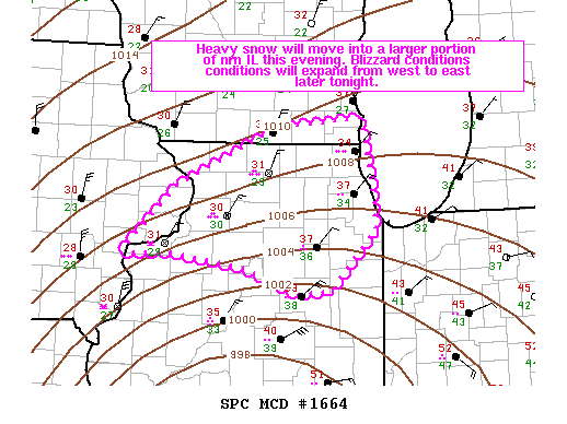 |
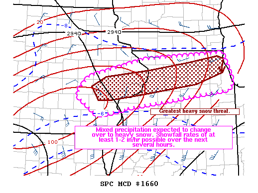
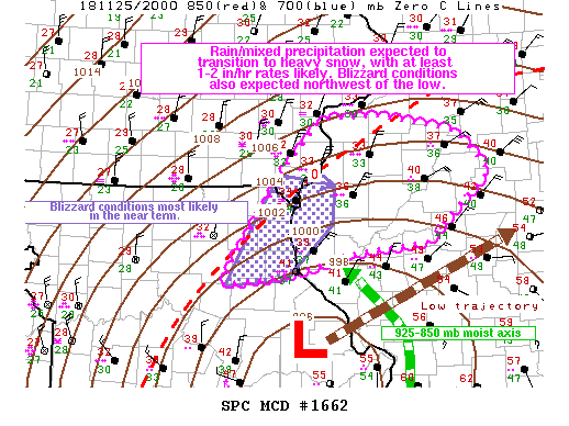
| Figure 1: Storm Prediction Center Mesoscale Discussion #1660 (link to text) | Figure 2: Storm Prediction Center Mesoscale Discussion #1662 (link to text) | Figure 3: Storm Prediction Center Mesoscale Discussion #1664 (link to text) |
 |
 |
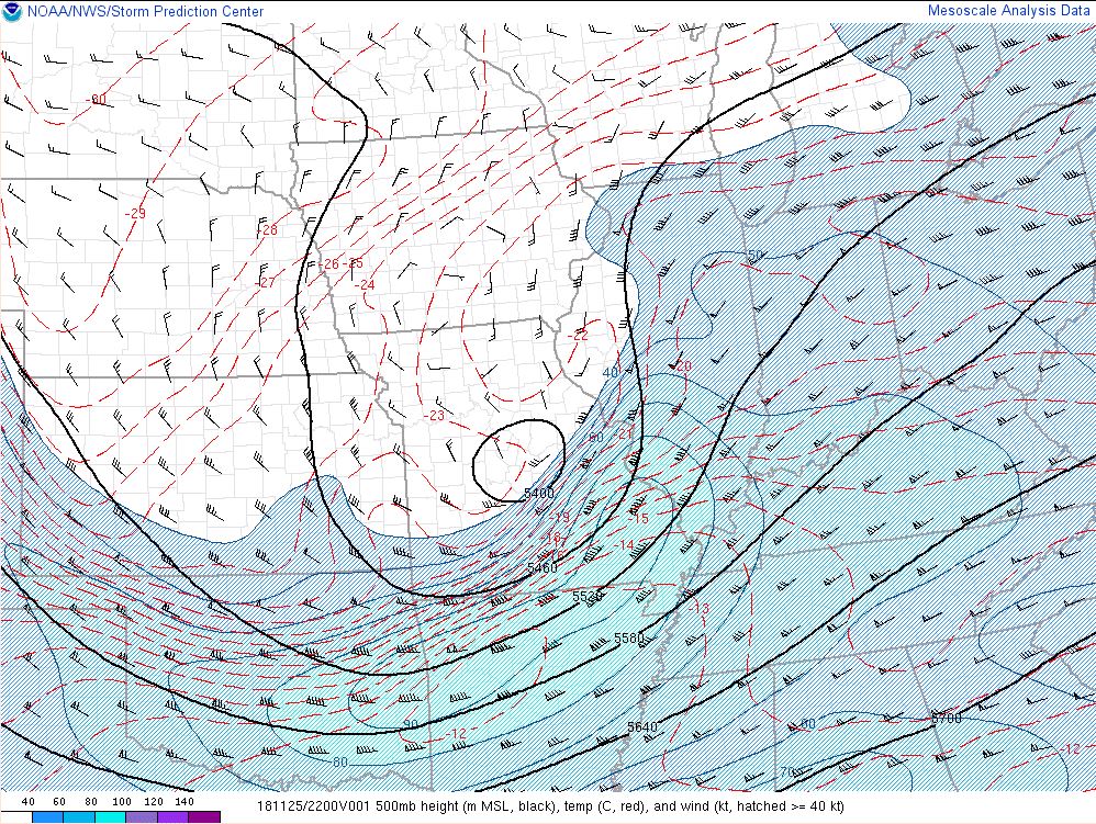 |
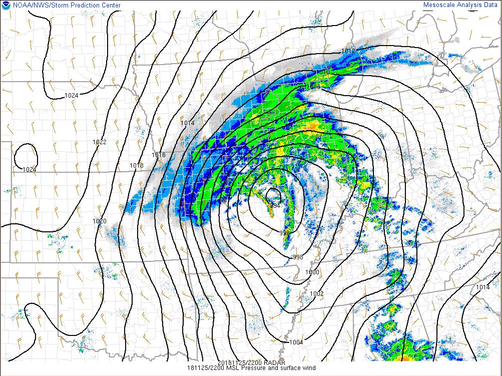
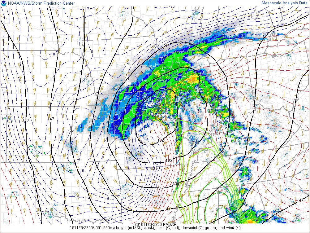
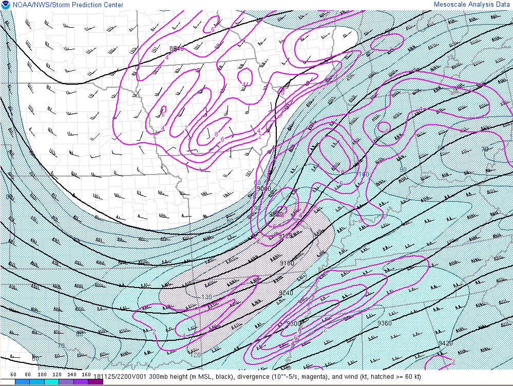
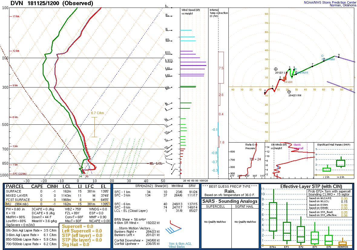
| Figure 4: Mean Sea Level Pressure @ 22Z (SPC Mesoanalysis) | Figure 5: 850 mb Analysis @ 22Z (SPC Mesoanalysis) | Figure 6: 500 mb Analysis @ 22Z (SPC Mesoanalysis) |
 |
 |
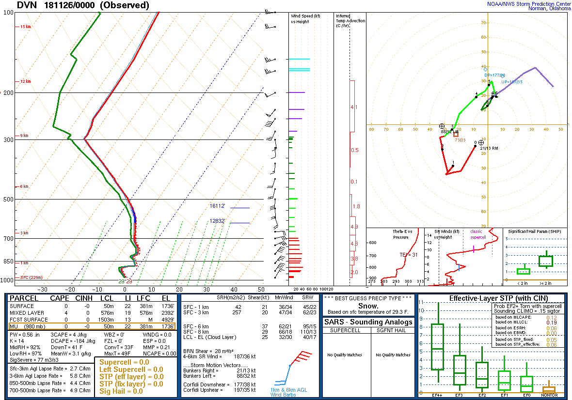 |
| Figure 7: 300 mb Analysis @ 22Z (SPC Mesoanalysis) | Figure 8: KDVN Sounding 11/25/18 12Z | Figure 9: KDVN Sounding 11/26/18 00Z |
.jpg) |
 |
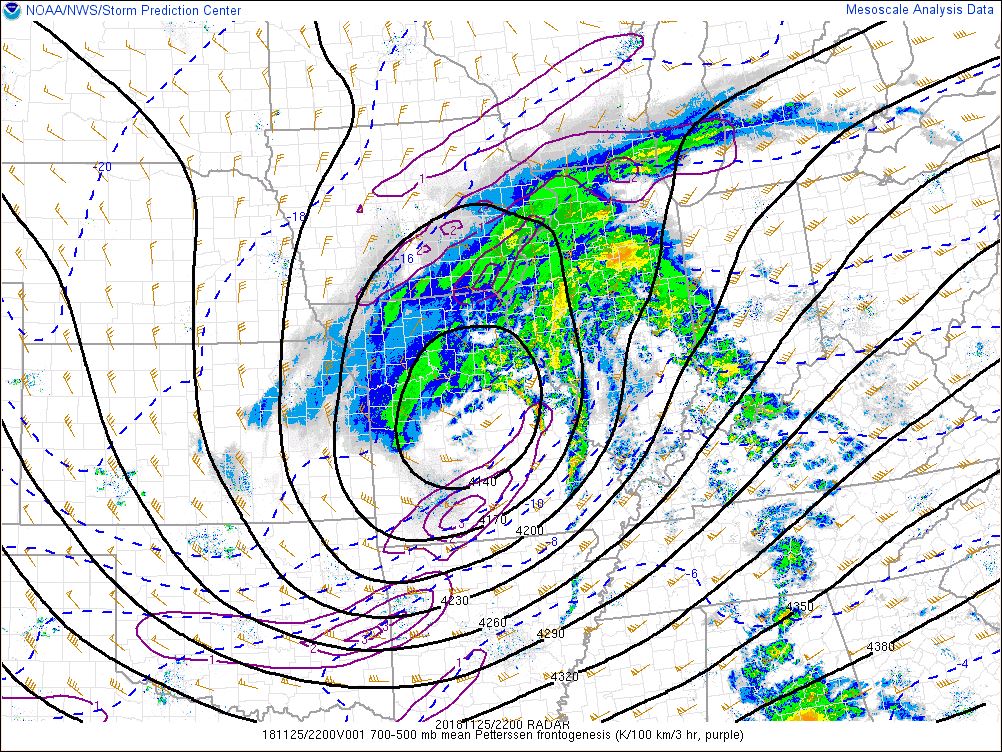 |
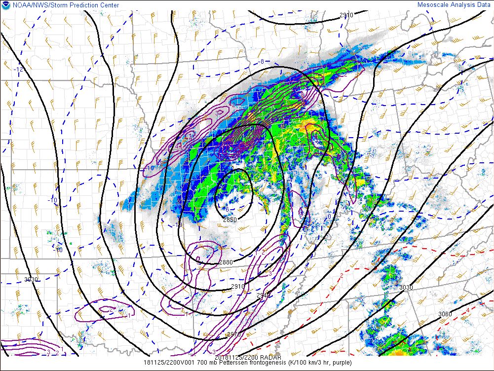
| Figure 10: 850-700 mb Frontogenesis @ 22Z (SPC Mesoanalysis) | Figure 11: 700 mb Frontogenesis @ 22Z (SPC Mesoanalysis) | Figure 12: 700-500 mb Frontogenesis @ 22Z (SPC Mesoanalysis) |
 |
 |
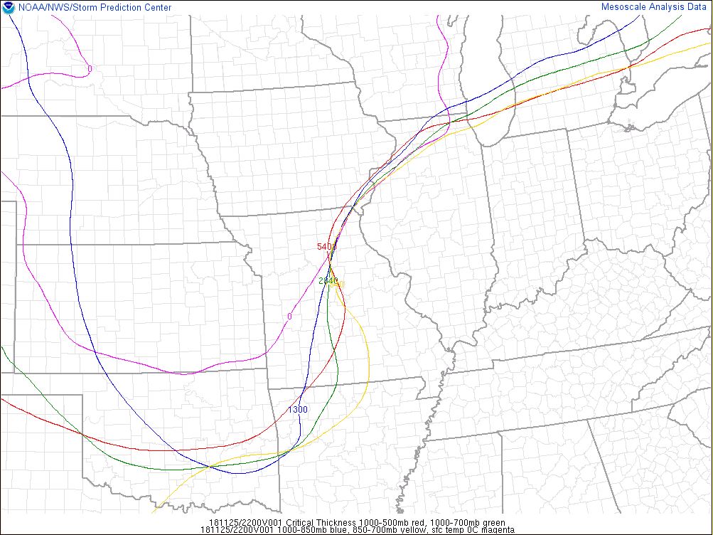 |
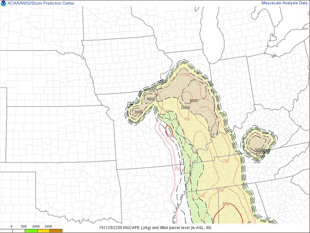
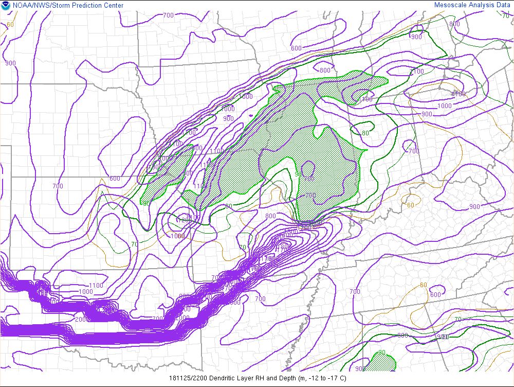
| Figure 13: Most Unstable CAPE Analysis @ 22Z (SPC Mesoanalysis) | Figure 14: Dendritic Growth Zone Depth & Relative Humidity @ 22Z (SPC Mesoanalysis) | Figure 15: Critical Thicknesses Analysis @ 22Z (SPC Mesoanalysis) |
 |
||
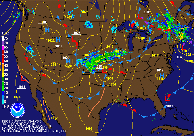
| Sea Level Pressure/Fronts/ Radar Loop |
 |
Media use of NWS Web News Stories is encouraged! Please acknowledge the NWS as the source of any news information accessed from this site. |
|