Record setting heat is expected over the next several days from the Intermountain West through the northern Plains. Furthermore, fire weather concerns increase with dry and breezy conditions. Meanwhile, heavy rainfall and severe thunderstorm threats for the Ohio/Tennessee Valleys, central Appalachians and Southeast today. The threat shifts to central Gulf Coast and across central Texas this week. Read More >
Overview
|
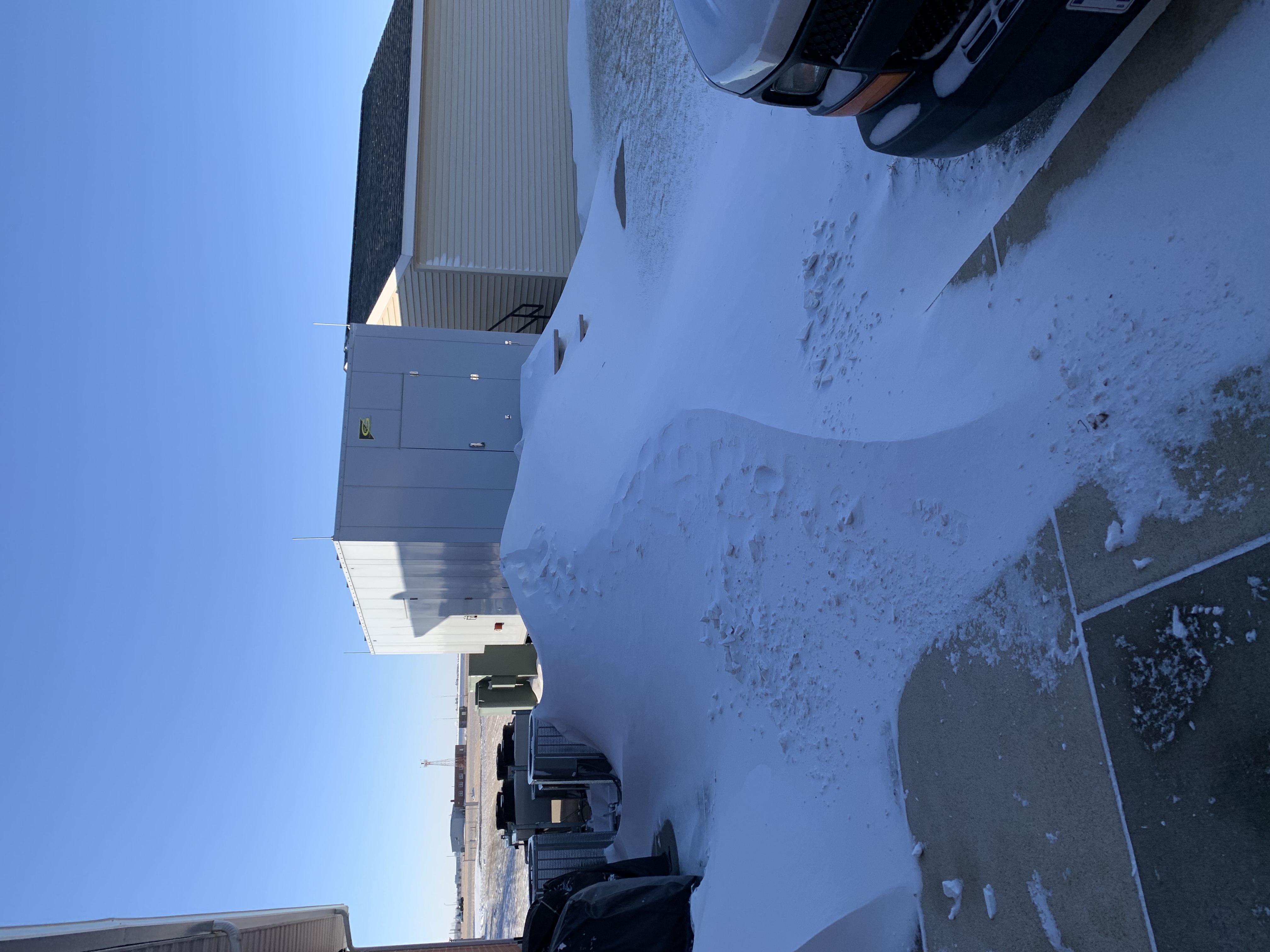
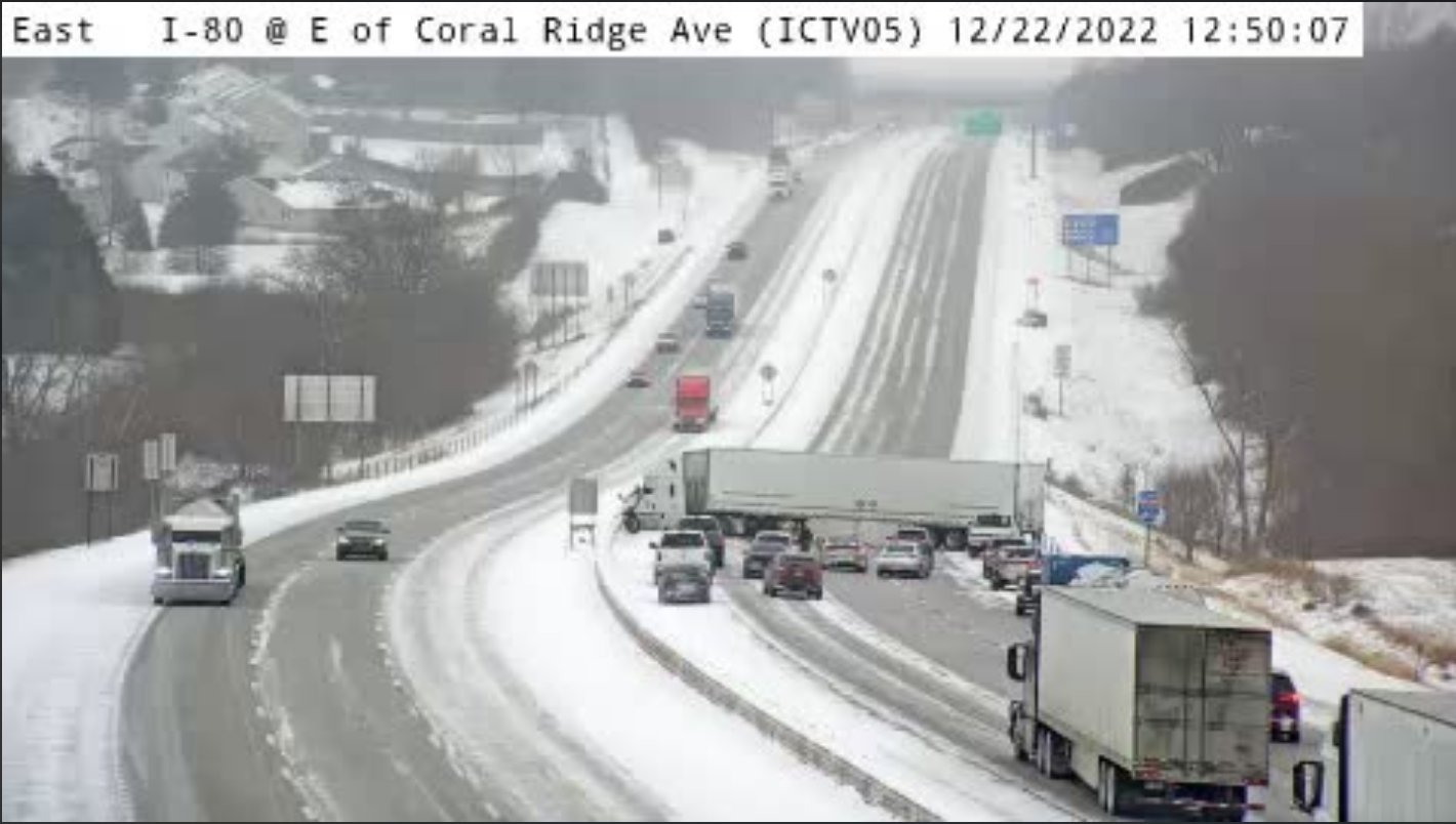
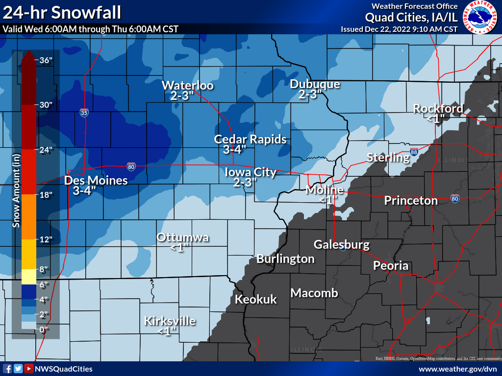
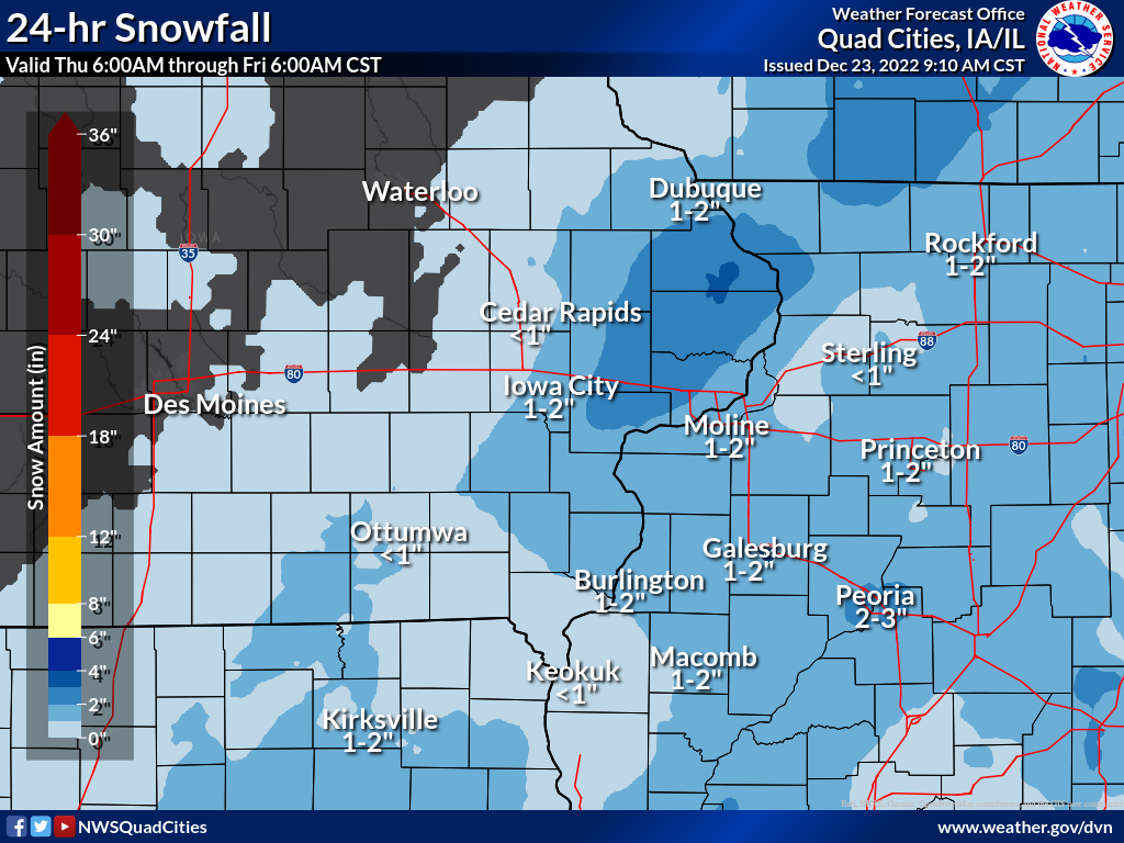
A strong winter storm brought widespread snow to the region Thursday, with amounts generally between 1-4 inches. Some higher totals near 6 inches were reported in eastern Linn and Cedar counties. Strong winds also accompanied the snow which caused significant blowing and drifting, especially in rural areas. Many accidents were reported on Interstate 80, causing frequent backups. Even stronger winds were observed on Friday across the area. Wind gusts between 40-50 mph were common, creating ground blizzard conditions primarily along and north of Interstate 80 in Iowa. In addition, temperatures dropped sharply behind the arctic cold front on Thursday and continued to fall throughout the day. Single digit temperatures with wind chills between -20 and -40 degrees were common. NWS Official Totals Moline: 0.9"
|
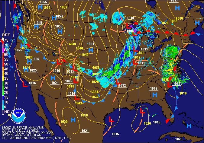 Weather Prediction Center Surface Analysis/Fronts/Radar 9am Thursday |
||||
|
|||||
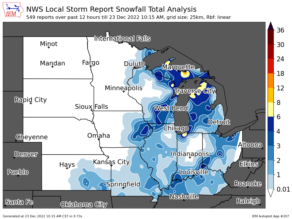
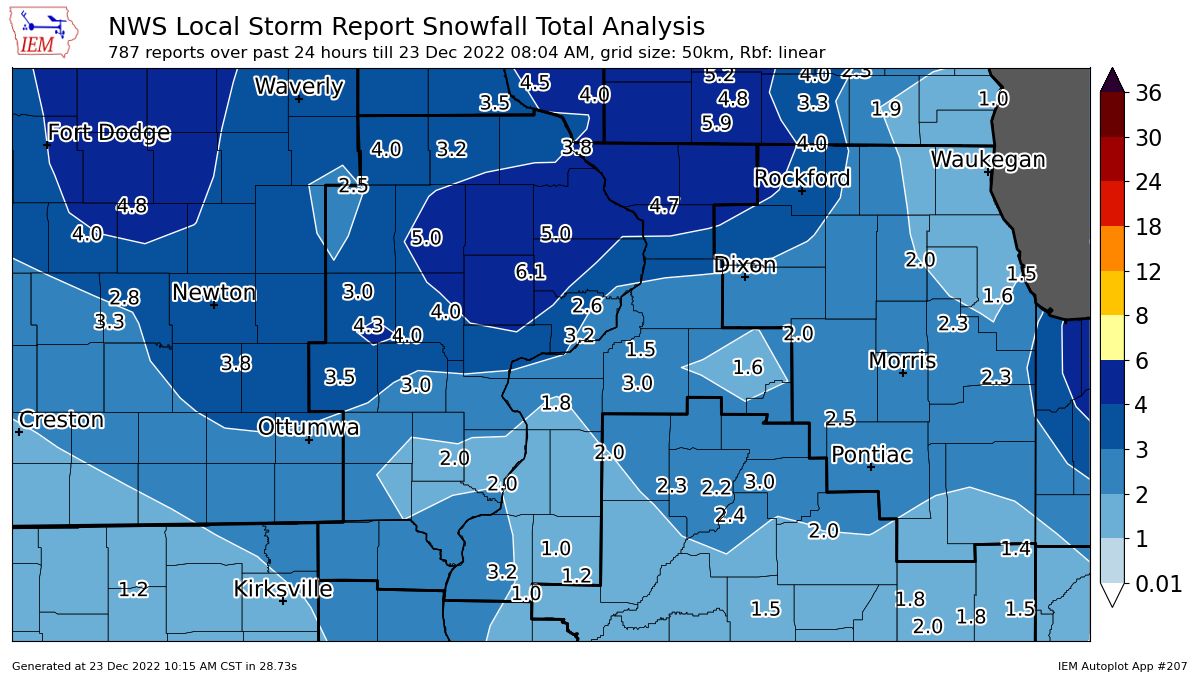
Snow Maps
| Local Snowfall Map (12-22) | Local Snowfall Map (12-23) | Regional Snow Map (courtesy IEM) |
 |
 |
 |
| Local Snow Analysis (courtesy IEM) | ||
 |
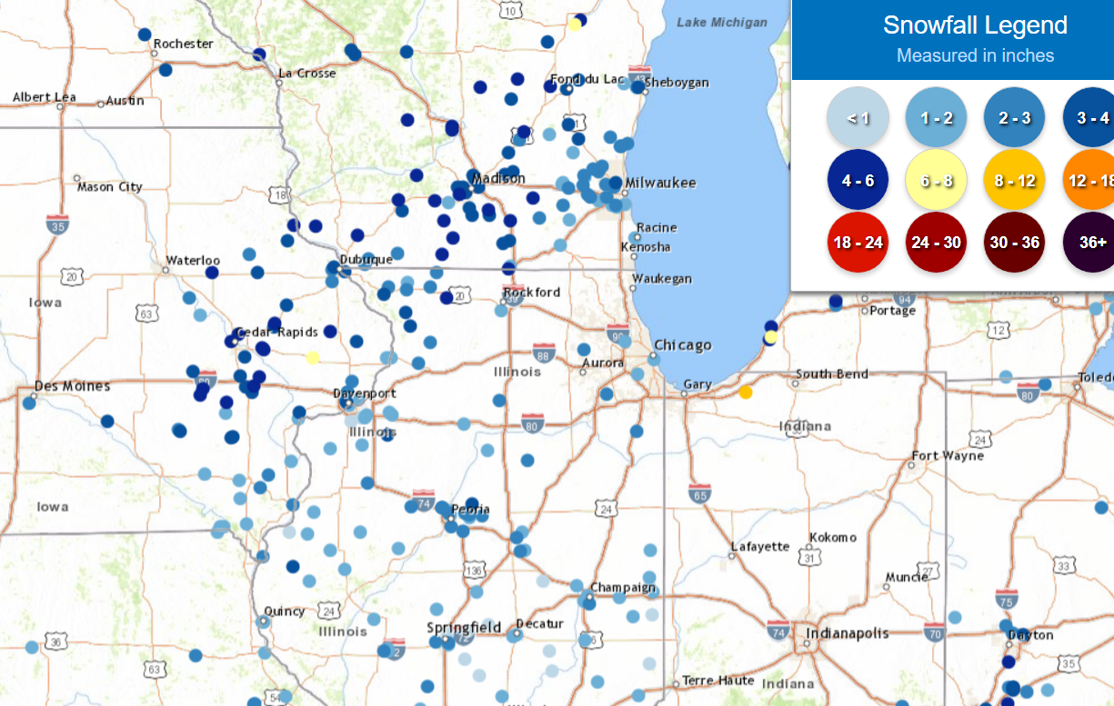
Storm Reports
Storm Reports Map - Courtesy IEM
 |
PRELIMINARY LOCAL STORM REPORT...SUMMARY
NATIONAL WEATHER SERVICE QUAD CITIES IA IL
936 AM CST FRI DEC 23 2022
..TIME... ...EVENT... ...CITY LOCATION... ...LAT.LON...
..DATE... ....MAG.... ..COUNTY LOCATION..ST.. ...SOURCE....
..REMARKS..
0700 AM SNOW LOWDEN 41.86N 90.92W
12/23/2022 M6.1 INCH CEDAR IA CO-OP OBSERVER
STORM TOTAL.
0942 AM SNOW 2 WSW MARION 42.03N 91.62W
12/22/2022 M5.0 INCH LINN IA TRAINED SPOTTER
0700 AM SNOW 1 W MAQUOKETA MUNICIPAL 42.05N 90.75W
12/23/2022 M5.0 INCH JACKSON IA CO-OP OBSERVER
CO-OP OBSERVER STATION MKTI4 MAQUOKETA.
0700 AM SNOW 6 SSE ELMOVILLE 42.19N 90.02W
12/23/2022 M4.7 INCH CARROLL IL COCORAHS
COCORAHS STATION IL-CR-12 MOUNT CARROLL 6.8
NNW.
0148 PM SNOW ANAMOSA 42.11N 91.29W
12/22/2022 M4.6 INCH JONES IA TRAINED SPOTTER
0700 AM SNOW 2 SE WILLIAMSBURG 41.64N 91.98W
12/23/2022 M4.3 INCH IOWA IA CO-OP OBSERVER
CO-OP OBSERVER STATION WLBI4 1 E
WILLIAMSBURG.
1158 AM SNOW 2 ESE HIAWATHA 42.03N 91.64W
12/22/2022 M4.2 INCH LINN IA BROADCAST MEDIA
UPDATED SNOWFALL AMOUNT.
1024 AM SNOW INDEPENDENCE 42.47N 91.89W
12/22/2022 E4.0 INCH BUCHANAN IA EMERGENCY MNGR
1120 AM SNOW 2 W CEDAR RAPIDS 41.98N 91.71W
12/22/2022 M4.0 INCH LINN IA TRAINED SPOTTER
UPDATED TOTAL.
1153 AM SNOW LISBON 41.92N 91.39W
12/22/2022 M4.0 INCH LINN IA TRAINED SPOTTER
0700 AM SNOW 2 E IOWA CITY 41.66N 91.49W
12/23/2022 M4.0 INCH JOHNSON IA COCORAHS
COCORAHS STATION IA-JH-34 IOWA CITY 2.3 E.
0700 AM SNOW LISBON 41.92N 91.39W
12/23/2022 M4.0 INCH LINN IA COCORAHS
COCORAHS STATION IA-LN-56 LISBON 0.1 W.
1239 PM SNOW 1 SW UNIVERSITY HEIGHTS 41.65N 91.57W
12/22/2022 E3.9 INCH JOHNSON IA TRAINED SPOTTER
SNOW ENDED. EVENT TOTAL.
0700 AM SNOW 2 SE EAST DUBUQUE 42.48N 90.61W
12/23/2022 M3.8 INCH JO DAVIESS IL COCORAHS
COCORAHS STATION IL-JD-11 EAST DUBUQUE 1.7
SE.
0700 AM SNOW 3 NNE MC CONNELL 42.47N 89.72W
12/23/2022 M3.8 INCH STEPHENSON IL COCORAHS
COCORAHS STATION IL-SP-8 WINSLOW 4.3 ESE.
0700 AM SNOW 1 WNW DUBUQUE 42.51N 90.72W
12/23/2022 M3.7 INCH DUBUQUE IA COCORAHS
COCORAHS STATION IA-DB-27 DUBUQUE 1.4 WNW.
0700 AM SNOW 6 SSE ELMOVILLE 42.19N 90.02W
12/23/2022 M3.5 INCH CARROLL IL COCORAHS
COCORAHS STATION IL-CR-12 MOUNT CARROLL 6.8
NNW.
0800 AM SNOW 1 NNW MONTICELLO MUNICI 42.24N 91.17W
12/23/2022 M3.5 INCH JONES IA CO-OP OBSERVER
CO-OP OBSERVER STATION MCLI4 MONTICELLO.
0800 AM SNOW SIGOURNEY 41.33N 92.20W
12/23/2022 M3.5 INCH KEOKUK IA CO-OP OBSERVER
CO-OP OBSERVER STATION SGYI4 SIGOURNEY.
0600 AM SNOW ELY 41.87N 91.58W
12/23/2022 M3.3 INCH LINN IA COCORAHS
COCORAHS STATION IA-LN-3 ELY 0.5 SE.
0603 AM SNOW 1 SE DAVENPORT 41.54N 90.59W
12/23/2022 M3.2 INCH SCOTT IA COCORAHS
COCORAHS STATION IA-ST-37 DAVENPORT 0.9 WNW.
0700 AM SNOW 1 SSE MANCHESTER 42.47N 91.45W
12/23/2022 M3.2 INCH DELAWARE IA CO-OP OBSERVER
CO-OP OBSERVER STATION MHRI4 MANCHESTER.
0800 AM SNOW BENTLEY 40.34N 91.11W
12/23/2022 M3.2 INCH HANCOCK IL CO-OP OBSERVER
CO-OP OBSERVER STATION BTYI2 BENTLEY.
0700 AM SNOW 2 ESE FAIRVIEW 42.08N 91.30W
12/23/2022 M3.1 INCH JONES IA CO-OP OBSERVER
CO-OP OBSERVER STATION AMOI4 ANAMOSA 3 SSW.
0936 AM SNOW 2 NNW NORTH LIBERTY 41.76N 91.62W
12/22/2022 E3.0 INCH JOHNSON IA TRAINED SPOTTER
0945 AM SNOW NORTH ENGLISH 41.51N 92.07W
12/22/2022 M3.0 INCH IOWA IA TRAINED SPOTTER
0603 AM SNOW 1 SE DAVENPORT 41.54N 90.59W
12/23/2022 M3.0 INCH SCOTT IA COCORAHS
COCORAHS STATION IA-ST-37 DAVENPORT 0.9 WNW.
0630 AM SNOW ELIZABETH 42.32N 90.23W
12/23/2022 M3.0 INCH JO DAVIESS IL CO-OP OBSERVER
CO-OP OBSERVER STATION EZBI2 ELIZABETH.
0700 AM SNOW 3 SSW MARENGO 41.76N 92.08W
12/23/2022 M3.0 INCH IOWA IA COCORAHS
COCORAHS STATION IA-IA-2 MARENGO 2.6 SSW.
0700 AM SNOW 3 SE IOWA CITY MUNICIPA 41.61N 91.51W
12/23/2022 M3.0 INCH JOHNSON IA CO-OP OBSERVER
CO-OP OBSERVER STATION ICYI4 IOWA CITY.
0700 AM SNOW 4 NNE MUSCATINE 41.47N 91.05W
12/23/2022 M3.0 INCH MUSCATINE IA CO-OP OBSERVER
CO-OP OBSERVER STATION MSTI4 2 N MUSCATINE.
0700 AM SNOW 1 SW WASHINGTON 41.28N 91.71W
12/23/2022 M3.0 INCH WASHINGTON IA CO-OP OBSERVER
CO-OP OBSERVER STATION WSHI4 WASHINGTON 2
SSW.
0700 AM SNOW 2 WNW CHARLOTTE 41.98N 90.50W
12/23/2022 M3.0 INCH CLINTON IA COCORAHS
COCORAHS STATION IA-CN-17 CHARLOTTE 1.9 WNW.
0700 AM SNOW 1 W MAQUOKETA MUNICIPAL 42.05N 90.75W
12/23/2022 M3.0 INCH JACKSON IA CO-OP OBSERVER
CO-OP OBSERVER STATION MKTI4 MAQUOKETA.
0800 AM SNOW 1 SSW NORTH LIBERTY 41.73N 91.62W
12/23/2022 M3.0 INCH JOHNSON IA COCORAHS
COCORAHS STATION IA-JH-27 NORTH LIBERTY 0.7
SSW.
0600 AM SNOW 1 NW DUBUQUE REGIONAL A 42.41N 90.73W
12/23/2022 M2.9 INCH DUBUQUE IA CO-OP OBSERVER
CO-OP OBSERVER STATION DUBI4 DUBUQUE 7 SSW.
1236 PM SNOW 1 NW DUBUQUE REGIONAL A 42.41N 90.73W
12/22/2022 M2.7 INCH DUBUQUE IA OFFICIAL NWS OBS
1.4 INCHES SINCE 6 AM.
0700 AM SNOW PARK VIEW 41.69N 90.54W
12/23/2022 M2.6 INCH SCOTT IA COCORAHS
COCORAHS STATION IA-ST-3 PARK VIEW 0.2 WSW.
1115 AM SNOW DAVENPORT 41.56N 90.60W
12/22/2022 E2.5 INCH SCOTT IA TRAINED SPOTTER
1151 AM SNOW 2 ESE LENA 42.37N 89.78W
12/22/2022 M2.5 INCH STEPHENSON IL TRAINED SPOTTER
0600 AM SNOW 2 NNW MOUNT AUBURN 42.29N 92.11W
12/23/2022 M2.5 INCH BENTON IA COCORAHS
COCORAHS STATION IA-BT-11 MOUNT AUBURN 2.2
NNW.
0700 AM SNOW 1 NE DUNDEE 42.60N 91.53W
12/23/2022 M2.5 INCH DELAWARE IA COCORAHS
COCORAHS STATION IA-DW-10 1 NE DUNDEE.
0700 AM SNOW 3 NNE MC CONNELL 42.47N 89.72W
12/23/2022 M2.5 INCH STEPHENSON IL COCORAHS
COCORAHS STATION IL-SP-8 WINSLOW 4.3 ESE.
0550 AM SNOW 3 W RICHMOND 41.46N 91.76W
12/23/2022 M2.3 INCH WASHINGTON IA COCORAHS
COCORAHS STATION IA-WS-7 WELLMAN 4.0 E.
0600 AM SNOW DAVENPORT MUNICIPALITY 41.61N 90.58W
12/23/2022 M2.3 INCH SCOTT IA CO-OP OBSERVER
CO-OP OBSERVER STATION DVNI4 DAVENPORT 6 N.
1146 AM SNOW 2 SSE SCHAPVILLE 42.37N 90.19W
12/22/2022 M2.2 INCH JO DAVIESS IL TRAINED SPOTTER
0800 AM SNOW SIGOURNEY 41.33N 92.20W
12/23/2022 M2.2 INCH KEOKUK IA CO-OP OBSERVER
CO-OP OBSERVER STATION SGYI4 SIGOURNEY.
1144 AM SNOW MILLEDGEVILLE 41.97N 89.78W
12/22/2022 M2.1 INCH CARROLL IL TRAINED SPOTTER
1200 PM SNOW DAVENPORT AIRPORT 41.61N 90.58W
12/22/2022 M2.1 INCH SCOTT IA OFFICIAL NWS OBS
STORM TOTAL SO FAR, 1.6 INCHES SINCE 6 AM.
1147 AM SNOW KEOKUK 40.41N 91.40W
12/22/2022 M2.0 INCH LEE IA PUBLIC
0700 AM SNOW 2 SW YARMOUTH 41.01N 91.35W
12/23/2022 M2.0 INCH DES MOINES IA COCORAHS
COCORAHS STATION IA-DM-15 2 WSW YARMOUTH.
0700 AM SNOW 3 SSW MALVERN 41.82N 89.90W
12/23/2022 M2.0 INCH WHITESIDE IL COCORAHS
COCORAHS STATION IL-WD-5 MORRISON 3.2 E.
0700 AM SNOW PARK VIEW 41.69N 90.54W
12/23/2022 M2.0 INCH SCOTT IA COCORAHS
COCORAHS STATION IA-ST-3 PARK VIEW 0.2 WSW.
0700 AM SNOW 4 NNE MUSCATINE 41.47N 91.05W
12/23/2022 M2.0 INCH MUSCATINE IA CO-OP OBSERVER
CO-OP OBSERVER STATION MSTI4 2 N MUSCATINE.
0700 AM SNOW 1 SW WASHINGTON 41.28N 91.71W
12/23/2022 M2.0 INCH WASHINGTON IA CO-OP OBSERVER
CO-OP OBSERVER STATION WSHI4 WASHINGTON 2
SSW.
0941 AM SNOW MOUNT CARROLL 42.09N 89.98W
12/22/2022 M1.9 INCH CARROLL IL TRAINED SPOTTER
0600 AM SNOW 2 NE CLINTON 41.86N 90.21W
12/23/2022 M1.9 INCH CLINTON IA COCORAHS
COCORAHS STATION IA-CN-22 CLINTON 1.7 NNW.
0715 AM SNOW 3 N STOCKTON 42.40N 90.00W
12/23/2022 M1.9 INCH JO DAVIESS IL CO-OP OBSERVER
CO-OP OBSERVER STATION STOI2 STOCKTON 3 NNE.
0700 AM SNOW ALEDO 41.20N 90.75W
12/23/2022 M1.8 INCH MERCER IL CO-OP OBSERVER
CO-OP OBSERVER STATION ALEI2 ALEDO.
0700 AM SNOW 2 ESE DAVENPORT 41.55N 90.56W
12/23/2022 M1.6 INCH SCOTT IA COCORAHS
COCORAHS STATION IA-ST-59 DAVENPORT 1.0 NE.
0700 AM SNOW PRINCETON 41.38N 89.46W
12/23/2022 M1.6 INCH BUREAU IL CO-OP OBSERVER
CO-OP OBSERVER STATION PTNI2 PRINCETON.
0800 AM SNOW 1 ENE VINTON 42.17N 92.01W
12/23/2022 M1.6 INCH BENTON IA CO-OP OBSERVER
CO-OP OBSERVER STATION VNTI4 VINTON.
1128 AM SNOW BETTENDORF 41.56N 90.48W
12/22/2022 M1.5 INCH SCOTT IA BROADCAST MEDIA
1147 AM SNOW 1 ESE MUSCATINE 41.42N 91.06W
12/22/2022 M1.5 INCH MUSCATINE IA PUBLIC
1200 AM SNOW 3 NNE ROCK ISLAND 41.52N 90.57W
12/23/2022 M1.5 INCH ROCK ISLAND IL MESONET
MESONET STATION RCKI2 2.9 N ROCK ISLAND.
0550 AM SNOW 3 W RICHMOND 41.46N 91.76W
12/23/2022 M1.5 INCH WASHINGTON IA COCORAHS
COCORAHS STATION IA-WS-7 WELLMAN 4.0 E.
0700 AM SNOW 1 S SALEM 40.84N 91.62W
12/23/2022 M1.5 INCH HENRY IA CO-OP OBSERVER
CO-OP OBSERVER STATION SLHI4 SALEM 1 S.
0700 AM SNOW DONNELLSON 40.65N 91.56W
12/23/2022 M1.5 INCH LEE IA CO-OP OBSERVER
CO-OP OBSERVER STATION DNNI4 DONNELLSON.
0700 AM SNOW 3 ESE AMBER 41.11N 91.13W
12/23/2022 M1.5 INCH LOUISA IA COCORAHS
COCORAHS STATION IA-LS-5 WAPELLO 5.4 SE.
0700 AM SNOW 1 SW STRONGHURST 40.74N 90.91W
12/23/2022 M1.5 INCH HENDERSON IL COCORAHS
COCORAHS STATION IL-HD-1 STRONGHURST 0.4
SSW.
0730 AM SNOW 2 NW GENESEO 41.47N 90.18W
12/23/2022 M1.5 INCH HENRY IL COCORAHS
COCORAHS STATION IL-HY-8 GENESEO 2.0 NW.
0800 AM SNOW 1 NNE FAIRFIELD 41.02N 91.96W
12/23/2022 M1.5 INCH JEFFERSON IA CO-OP OBSERVER
CO-OP OBSERVER STATION FRFI4 FAIRFIELD.
0600 AM SNOW 2 NE CLINTON 41.86N 90.21W
12/23/2022 M1.2 INCH CLINTON IA COCORAHS
COCORAHS STATION IA-CN-22 CLINTON 1.7 NNW.
0700 AM SNOW 2 SE COAL VALLEY 41.43N 90.42W
12/23/2022 M1.2 INCH HENRY IL COCORAHS
COCORAHS STATION IL-HY-5 COAL VALLEY 1.9 SE.
0700 AM SNOW 2 NNE NEW WINDSOR 41.23N 90.44W
12/23/2022 M1.2 INCH HENRY IL COCORAHS
COCORAHS STATION IL-HY-6 NEW WINDSOR 2.0 N.
1129 AM SNOW FULTON 41.86N 90.16W
12/22/2022 M1.0 INCH WHITESIDE IL TRAINED SPOTTER
1200 AM SNOW GENESEO 41.45N 90.15W
12/23/2022 M1.0 INCH HENRY IL CO-OP OBSERVER
CO-OP OBSERVER STATION GINI2 GENESEO.
0600 AM SNOW AUGUSTA 40.23N 90.95W
12/23/2022 M1.0 INCH HANCOCK IL CO-OP OBSERVER
CO-OP OBSERVER STATION AUGI2 AUGUSTA.
0600 AM SNOW 2 S PRAIRIE CITY 40.59N 90.46W
12/23/2022 M1.0 INCH MCDONOUGH IL CO-OP OBSERVER
CO-OP OBSERVER STATION PRCI2 2.0 S PRAIRIE
CITY.
0645 AM SNOW 3 W MACOMB 40.46N 90.75W
12/23/2022 M1.0 INCH MCDONOUGH IL COCORAHS
COCORAHS STATION IL-MCD-7 COLCHESTER 3.5 NE.
0700 AM SNOW 1 NW MC NABB 41.19N 89.23W
12/23/2022 M1.0 INCH PUTNAM IL COCORAHS
COCORAHS STATION IL-PM-6 MCNABB 1.4 NW.
0800 AM SNOW 2 NNW WARNER 41.45N 90.40W
12/23/2022 M1.0 INCH HENRY IL COCORAHS
COCORAHS STATION IL-HY-15 COAL VALLEY 2.6 E.
0800 AM SNOW 1 NNE FAIRFIELD 41.02N 91.96W
12/23/2022 M1.0 INCH JEFFERSON IA CO-OP OBSERVER
CO-OP OBSERVER STATION FRFI4 FAIRFIELD.
0800 AM SNOW LA HARPE 40.58N 90.97W
12/23/2022 M1.0 INCH HANCOCK IL CO-OP OBSERVER
CO-OP OBSERVER STATION LAHI2 LA HARPE.
0850 AM SNOW 4 W FARMINGTON 40.63N 91.81W
12/23/2022 M1.0 INCH VAN BUREN IA COCORAHS
COCORAHS STATION IA-VB-3 FARMINGTON 3.5 W.
0850 AM SNOW 2 W FARMINGTON 40.63N 91.78W
12/23/2022 M1.0 INCH VAN BUREN IA COCORAHS
COCORAHS STATION IA-VB-8 FARMINGTON 2.4 W.
0600 PM SNOW 3 SW QUAD CITY AIRPORT 41.40N 90.55W
12/22/2022 M0.9 INCH ROCK ISLAND IL OFFICIAL NWS OBS
STORM TOTAL, 0.2 TENTHS SINCE NOON.
1115 AM SNOW 3 ENE CHARLIE HEATH MEM 40.59N 91.84W
12/22/2022 E0.8 INCH CLARK MO TRAINED SPOTTER
0130 PM SNOW 2 NNE COLUSA 40.59N 91.15W
12/22/2022 M0.8 INCH HANCOCK IL TRAINED SPOTTER
SNOW TOTAL. GUSTY WINDS AND BLOWING SNOW
CONTINUE.
1021 AM SNOW REYNOLDS 41.33N 90.68W
12/22/2022 E0.2 INCH ROCK ISLAND IL TRAINED SPOTTER
Reports
...HIGHEST WIND GUST REPORTS... LOCATION SPEED TIME/DATE PROVIDER INDEPENDENCE 56 MPH 0430 PM 12/23 CWOP DAVENPORT ARPT 53 MPH 0321 PM 12/23 ASOS CEDAR RAPIDS ARPT 52 MPH 0413 PM 12/23 ASOS INDEPENDENCE ARPT 52 MPH 0955 AM 12/23 AWOS IOWA CITY ARPT 52 MPH 0306 PM 12/23 ASOS QUAD CITIES 51 MPH 0225 PM 12/23 MESOWEST ELDRIDGE 50 MPH 0946 AM 12/23 CWOP OLIN 49 MPH 0305 PM 12/23 CWOP BURLINGTON ARPT 49 MPH 0346 PM 12/23 ASOS DUBUQUE ARPT 49 MPH 0229 PM 12/23 ASOS QUAD CITY INTL ARPT 49 MPH 1254 PM 12/23 ASOS ANAMOSA 49 MPH 0415 PM 12/23 MESOWEST 1 NNE AURORA 48 MPH 0135 PM 12/23 AWS NEW LONDON 48 MPH 0410 PM 12/23 CWOP ELDRIDGE 48 MPH 0145 PM 12/23 CWOP WASHINGTON ARPT 48 MPH 0655 PM 12/23 AWOS SIGOURNEY 47 MPH 0100 PM 12/23 CWOP CLINTON ARPT 46 MPH 0554 PM 12/23 AWOS STERLING/ROCK FALLS ARPT 46 MPH 1125 AM 12/23 AWOS VICTOR 46 MPH 1205 PM 12/23 MESOWEST DUBUQUE 45 MPH 0147 PM 12/23 CWOP CEDAR RAPIDS 45 MPH 0320 PM 12/23 CWOP RIVERSIDE 45 MPH 0229 PM 12/23 CWOP MONMOUTH 45 MPH 1035 AM 12/23 CWOP MUSCATINE ARPT 45 MPH 0335 PM 12/23 AWOS DAVENPORT 45 MPH 0400 PM 12/23 MESOWEST WILLIAMSBURG 45 MPH 0330 PM 12/23 MESOWEST FAIRBANK 44 MPH 0545 PM 12/23 CWOP FAIRFIELD ARPT 44 MPH 0235 PM 12/23 AWOS VINTON ARPT 43 MPH 0355 PM 12/23 AWOS DE WITT 43 MPH 0300 PM 12/23 MESOWEST URBANA 43 MPH 0230 PM 12/23 MESOWEST FLAGSTAFF CHESHIRE 42 MPH 0315 PM 12/23 CWOP TIPTON 42 MPH 0230 PM 12/23 MESOWEST STOCKTON 41 MPH 1145 AM 12/23 CWOP MACOMB 41 MPH 1100 AM 12/23 CWOP MOUNT PLEASANT ARPT 41 MPH 0435 PM 12/23 AWOS SAVANNA ARPT 41 MPH 0323 PM 12/23 AWOS IOWA CITY US 218 41 MPH 0610 PM 12/23 MESOWEST URBANA 40 MPH 0229 PM 12/23 CWOP ELDRIDGE 40 MPH 1255 PM 12/23 DAVIS INDEPENDENCE 40 MPH 0415 PM 12/23 CWOP SIGOURNEY 40 MPH 0345 PM 12/23 MESOWEST |
...MINIMUM WIND CHILLS OVER THE PAST HOUR... LOCATION WC TEMP. TIME/DATE LAT/LON/ELEV (FT.) 1 NNE AURORA -37 F 0800 PM 12/23 42.64N/91.72W/1151 0.7 W BELLE PLAINE (UPR) -33 F 0713 PM 12/23 41.90N/92.29W/796 INDEPENDENCE ARPT -32 F 0735 PM 12/23 42.45N/91.95W/969 ANAMOSA -32 F 0730 PM 12/23 42.07N/91.34W/932 0.6 W LOWDEN (UPR) -32 F 0624 PM 12/23 41.86N/90.93W/720 DUBUQUE -31 F 0739 PM 12/23 42.46N/90.77W/971 DUBUQUE ARPT -31 F 0753 PM 12/23 42.40N/90.70W/1062 CLINTON ARPT -30 F 0756 PM 12/23 41.82N/90.32W/695 MECHANICSVILLE (UPR) -30 F 0634 PM 12/23 41.90N/91.26W/899 VICTOR -30 F 0730 PM 12/23 41.70N/92.28W/862 CEDAR RAPIDS ARPT -29 F 0808 PM 12/23 41.88N/91.72W/840 LOW MOOR (UPR) -29 F 0658 PM 12/23 41.80N/90.35W/638 ELDRIDGE -28 F 0730 PM 12/23 41.66N/90.57W/796 OLIN -28 F 0820 PM 12/23 42.02N/91.13W/803 0.5 N UNION GROVE (UPR) -28 F 0816 PM 12/23 41.84N/90.04W/679 CLINTON -27 F 0740 PM 12/23 41.81N/90.24W/591 OHIO -27 F 0740 PM 12/23 41.57N/89.40W/850 PARNELL -27 F 0755 PM 12/23 41.59N/91.85W/895 PEOSTA -27 F 0750 PM 12/23 42.46N/90.79W/1109 STOCKTON -27 F 0825 PM 12/23 42.40N/89.99W/974 MONMOUTH -27 F 0810 PM 12/23 40.93N/90.72W/750 STERLING/ROCK FALLS ARPT -27 F 0756 PM 12/23 41.75N/89.67W/644 DAVENPORT -27 F 0730 PM 12/23 41.60N/90.68W/731 URBANA -27 F 0710 PM 12/23 42.31N/91.98W/905 NEW LONDON -26 F 0800 PM 12/23 40.97N/91.34W/813 MARION -26 F 0755 PM 12/23 42.05N/91.58W/839 DEWITT -26 F 0755 PM 12/23 41.82N/90.54W/750 TIPTON -26 F 0810 PM 12/23 41.77N/91.13W/810 FAIRBANK -26 F 0815 PM 12/23 42.64N/92.05W/1013 RIVERSIDE -26 F 0815 PM 12/23 41.53N/91.62W/758 ELDRIDGE -26 F 0748 PM 12/23 41.64N/90.59W/775 DAVENPORT ARPT -26 F 0742 PM 12/23 41.62N/90.58W/748 FREEPORT ARPT -26 F 0735 PM 12/23 42.25N/89.58W/836 IOWA CITY ARPT -26 F 0752 PM 12/23 41.63N/91.55W/660 DE WITT -26 F 0740 PM 12/23 41.83N/90.57W/688 IOWA CITY US 218 -26 F 0740 PM 12/23 41.66N/91.60W/754 IOWA CITY I-80 -26 F 0740 PM 12/23 41.69N/91.58W/761 QUAD CITIES -26 F 0730 PM 12/23 41.52N/90.51W/550 WILLIAMSBURG -26 F 0805 PM 12/23 41.69N/92.01W/800 2.5 S CORALVILLE -25 F 0510 PM 12/23 41.66N/91.60W/791 WILLIAMSBURG -25 F 0825 PM 12/23 41.66N/92.02W/846 COLESBURG -25 F 0825 PM 12/23 42.62N/91.25W/1092 OAKVILLE -25 F 0820 PM 12/23 41.04N/91.01W/640 LONG GROVE -25 F 0735 PM 12/23 41.70N/90.57W/791 CAMBRIDGE -25 F 0751 PM 12/23 41.35N/90.23W/750 CEDAR RAPIDS -25 F 0735 PM 12/23 41.85N/91.64W/1217 BIG BEND -25 F 0745 PM 12/23 41.63N/90.04W/597 WASHINGTON ARPT -25 F 0815 PM 12/23 41.27N/91.67W/745 SAVANNA ARPT -25 F 0823 PM 12/23 42.05N/90.12W/607 TIPTON -25 F 0710 PM 12/23 41.64N/91.13W/691 WASHINGTON -25 F 0810 PM 12/23 41.29N/91.69W/755 CENTRAL CITY -24 F 0739 PM 12/23 42.21N/91.52W/883 ELDRIDGE -24 F 0745 PM 12/23 41.65N/90.59W/780 INDEPENDENCE -24 F 0815 PM 12/23 42.47N/91.89W/984 SIGOURNEY -24 F 0815 PM 12/23 41.34N/92.21W/770 MONMOUTH -24 F 0825 PM 12/23 40.93N/90.63W/750 CEDAR RAPIDS -24 F 0746 PM 12/23 42.05N/91.65W/847 FAIRFIELD ARPT -24 F 0815 PM 12/23 41.03N/91.97W/732 QUAD CITY INTL ARPT -24 F 0819 PM 12/23 41.45N/90.52W/584 MUSCATINE ARPT -24 F 0815 PM 12/23 41.37N/91.15W/541 DUBUQUE -24 F 0740 PM 12/23 42.49N/90.73W/853 SIGOURNEY -24 F 0740 PM 12/23 41.34N/92.31W/737 SPRING VALLEY AIRPORT -24 F 0735 PM 12/23 41.33N/89.21W/700 IOWA CITY -23 F 0733 PM 12/23 41.68N/91.52W/784 DANVILLE -23 F 0800 PM 12/23 40.88N/91.35W/852 KAHOKA -23 F 0820 PM 12/23 40.42N/91.72W/600 STERLING -23 F 0830 PM 12/23 41.82N/89.67W/711 PRINCETON -23 F 0800 PM 12/23 41.36N/89.47W/698 FREEPORT -23 F 0800 PM 12/23 42.28N/89.67W/869 BURLINGTON ARPT -23 F 0800 PM 12/23 40.77N/91.13W/670 KEOKUK ARPT -23 F 0815 PM 12/23 40.47N/91.42W/603 FORT MADISON ARPT -23 F 0755 PM 12/23 40.67N/91.32W/686 VINTON ARPT -23 F 0755 PM 12/23 42.22N/92.02W/822 MANCHESTER -23 F 0740 PM 12/23 42.47N/91.45W/941 IOWA CITY -22 F 0818 PM 12/23 41.65N/91.48W/751 STRONGHURST -22 F 0810 PM 12/23 40.74N/90.91W/675 INDEPENDENCE -22 F 0800 PM 12/23 42.47N/91.88W/936 DUBUQUE -22 F 0748 PM 12/23 42.51N/90.72W/634 GRANDVIEW -22 F 0745 PM 12/23 41.26N/91.17W/680 MAQUOKETA -22 F 0740 PM 12/23 42.07N/90.68W/734 AMANA -21 F 0815 PM 12/23 41.80N/91.88W/734 FLAGSTAFF CHESHIRE -21 F 0800 PM 12/23 41.59N/90.55W/739 URBANA -21 F 0814 PM 12/23 42.22N/91.88W/912 MACOMB -21 F 0800 PM 12/23 40.49N/90.69W/705 DUBUQUE -21 F 0746 PM 12/23 42.51N/90.67W/636 BUFFALO -21 F 0203 PM 12/23 40.98N/91.41W/722 MACOMB -21 F 0815 PM 12/23 40.47N/90.69W/679 BETTENDORF -21 F 0746 PM 12/23 41.56N/90.46W/642 MOUNT PLEASANT ARPT -21 F 0755 PM 12/23 40.95N/91.52W/701 LONE TREE (WEATHERSTEM) -20 F 0810 PM 12/23 41.49N/91.43W/728 3 S MOUNT JOY -20 F 0805 PM 12/23 41.57N/90.55W/663 2 SSE OSBORN -20 F 0757 PM 12/23 41.49N/90.25W/682 DANVILLE -20 F 0800 PM 12/23 40.85N/91.31W/722 MARION -20 F 0800 PM 12/23 42.05N/91.57W/875 INDEPENDENCE -20 F 0830 PM 12/23 42.48N/91.89W/3067 GALT (UPR) -20 F 0759 PM 12/23 41.79N/89.77W/643 |
 |
Media use of NWS Web News Stories is encouraged! Please acknowledge the NWS as the source of any news information accessed from this site. |
|