|
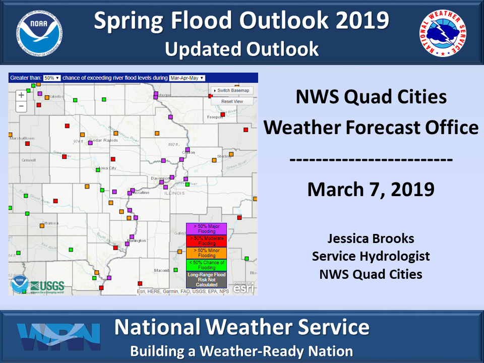
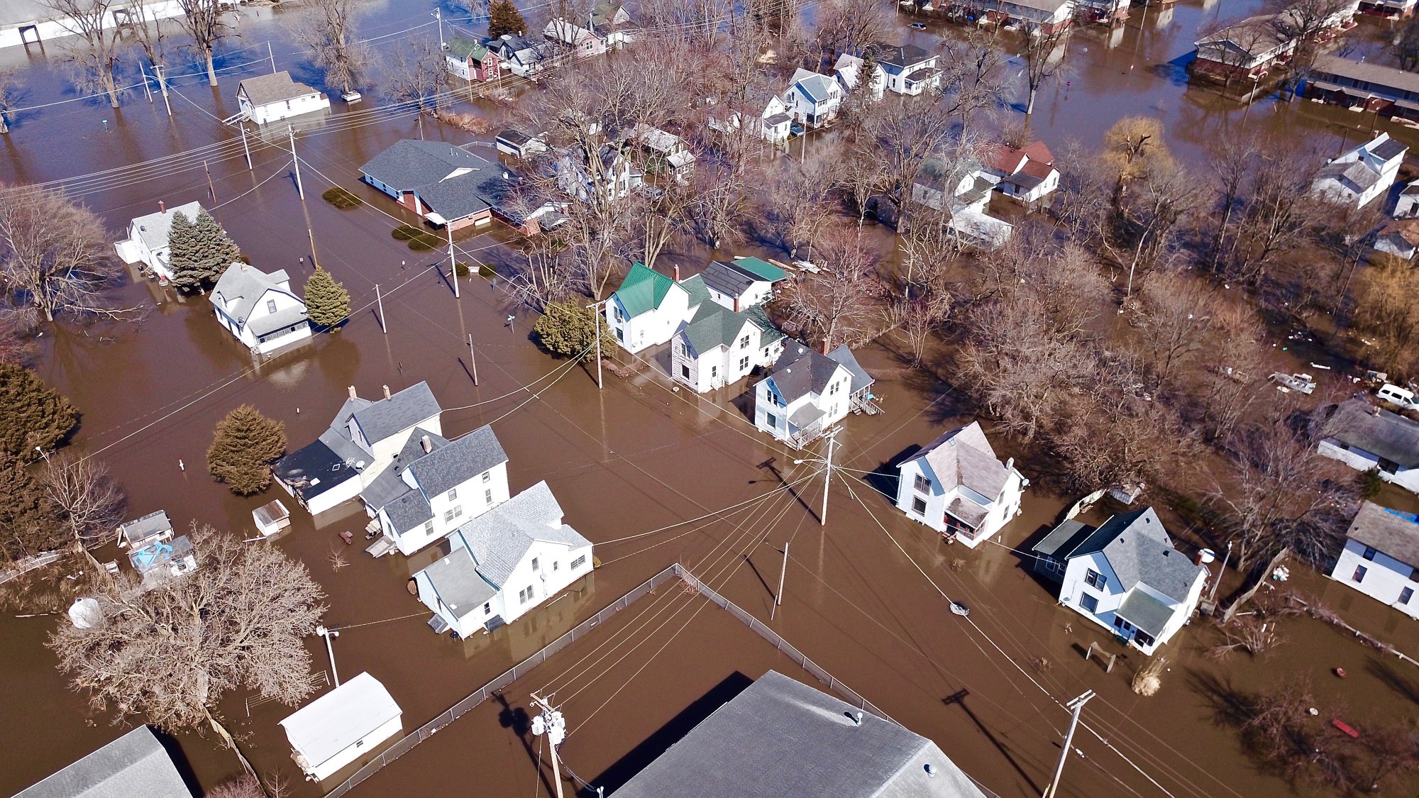
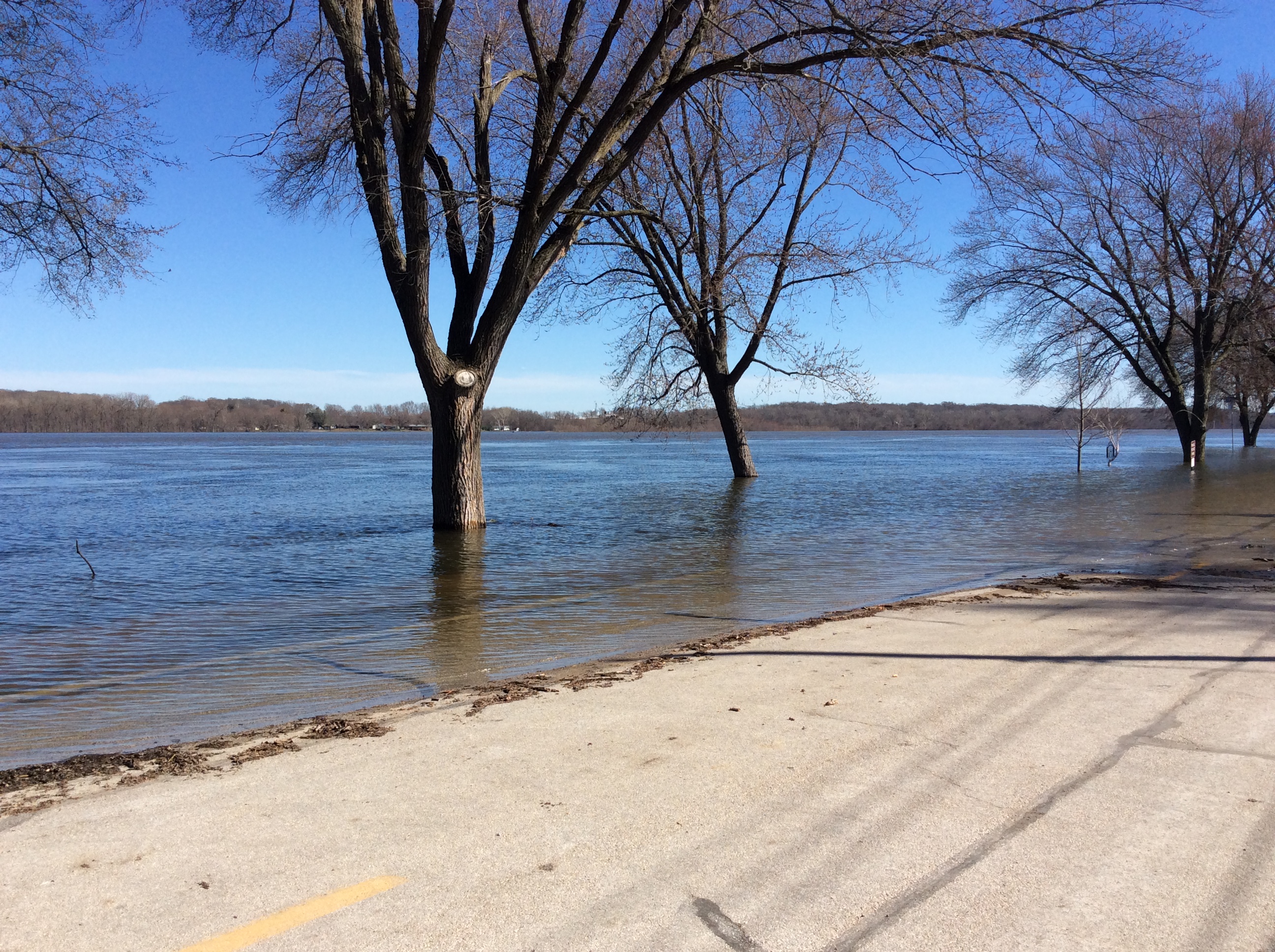
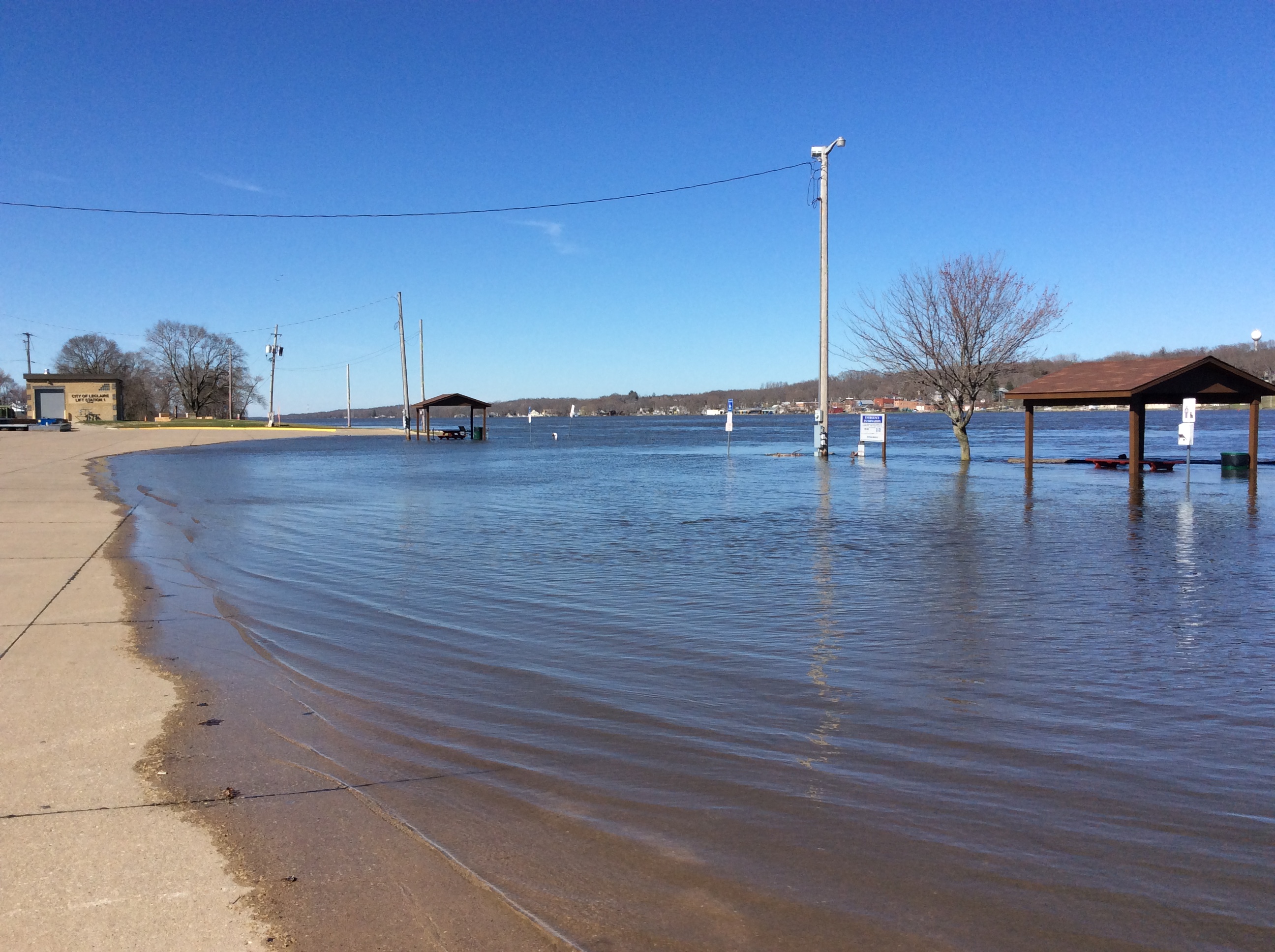
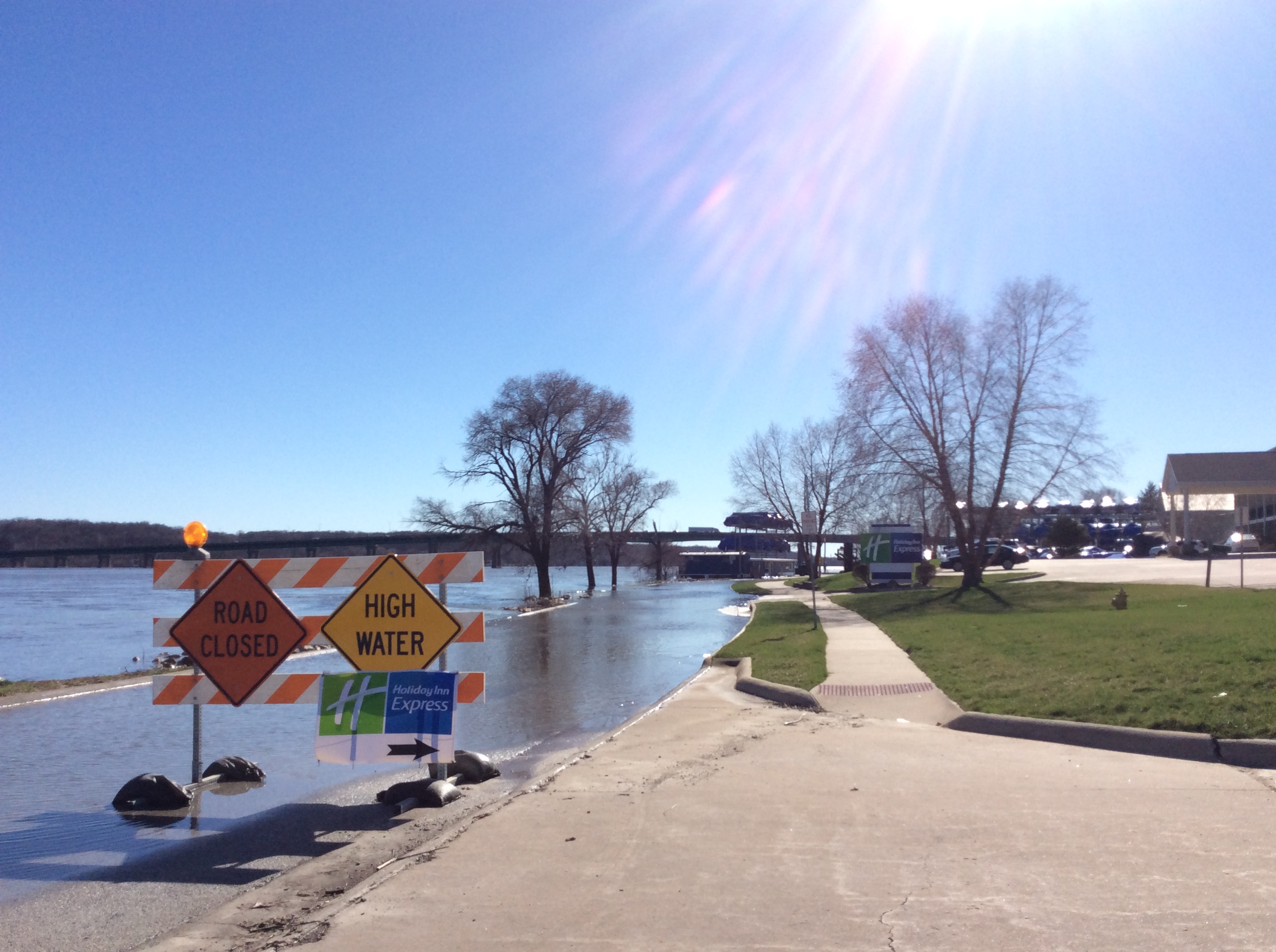
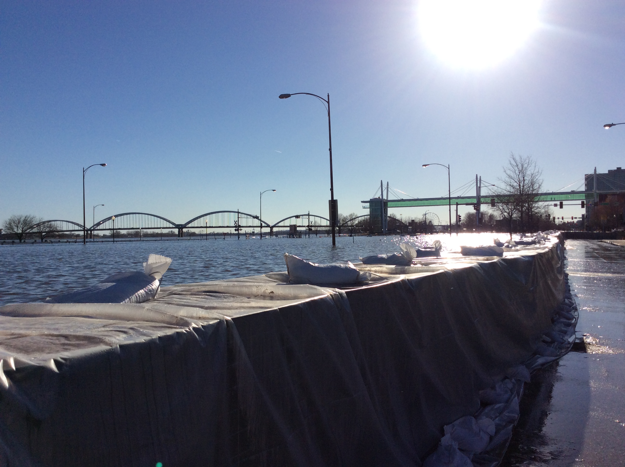
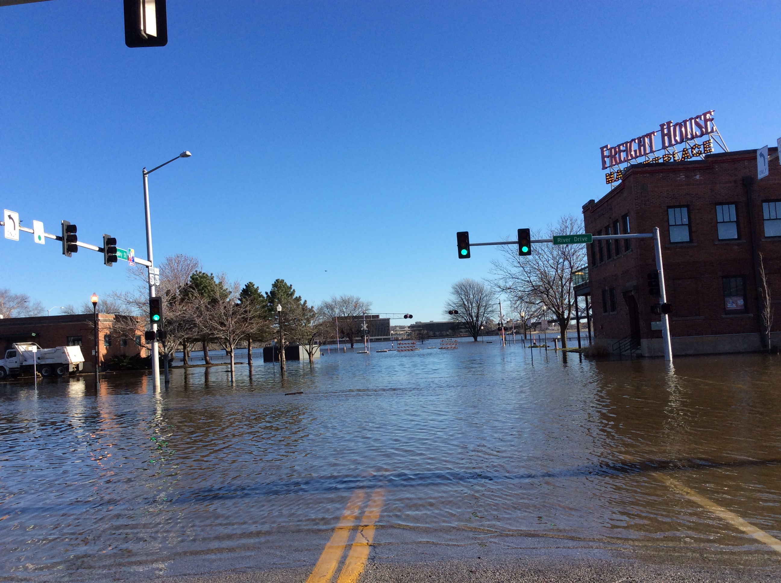
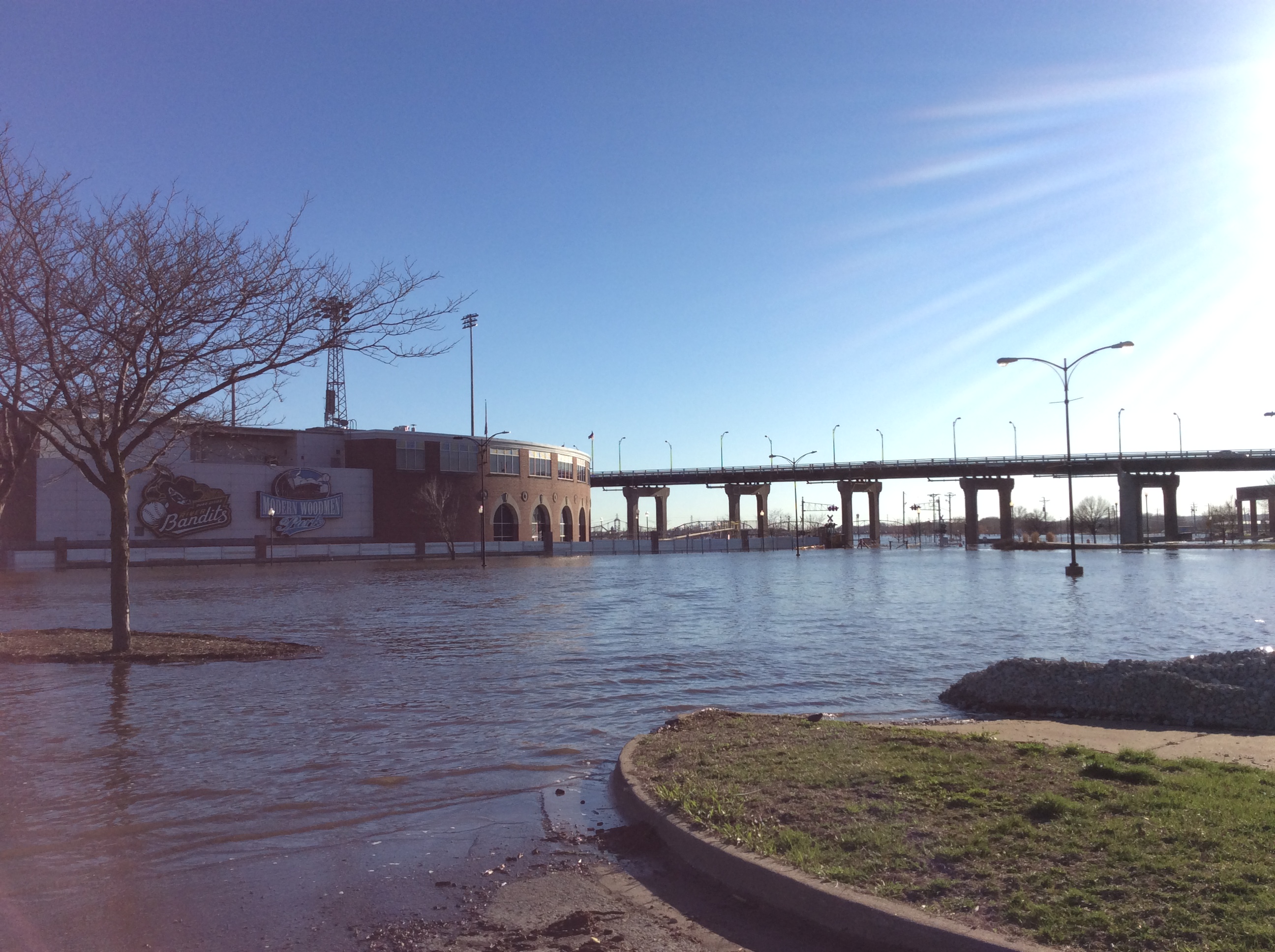
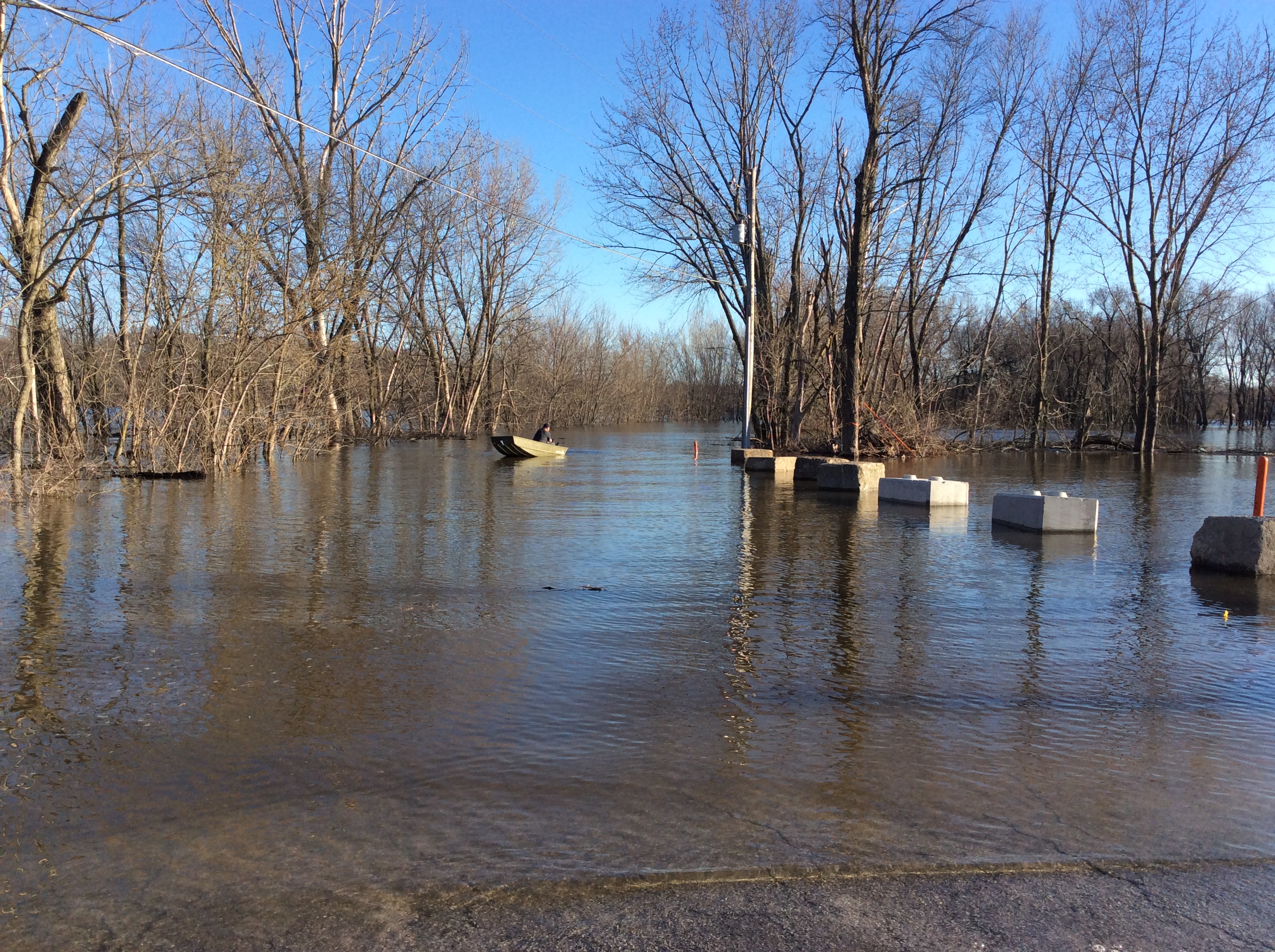
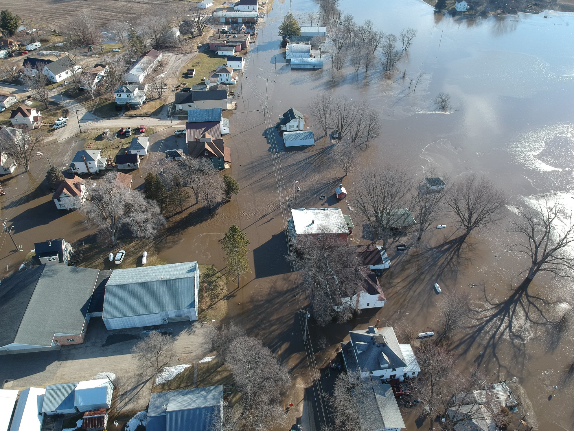
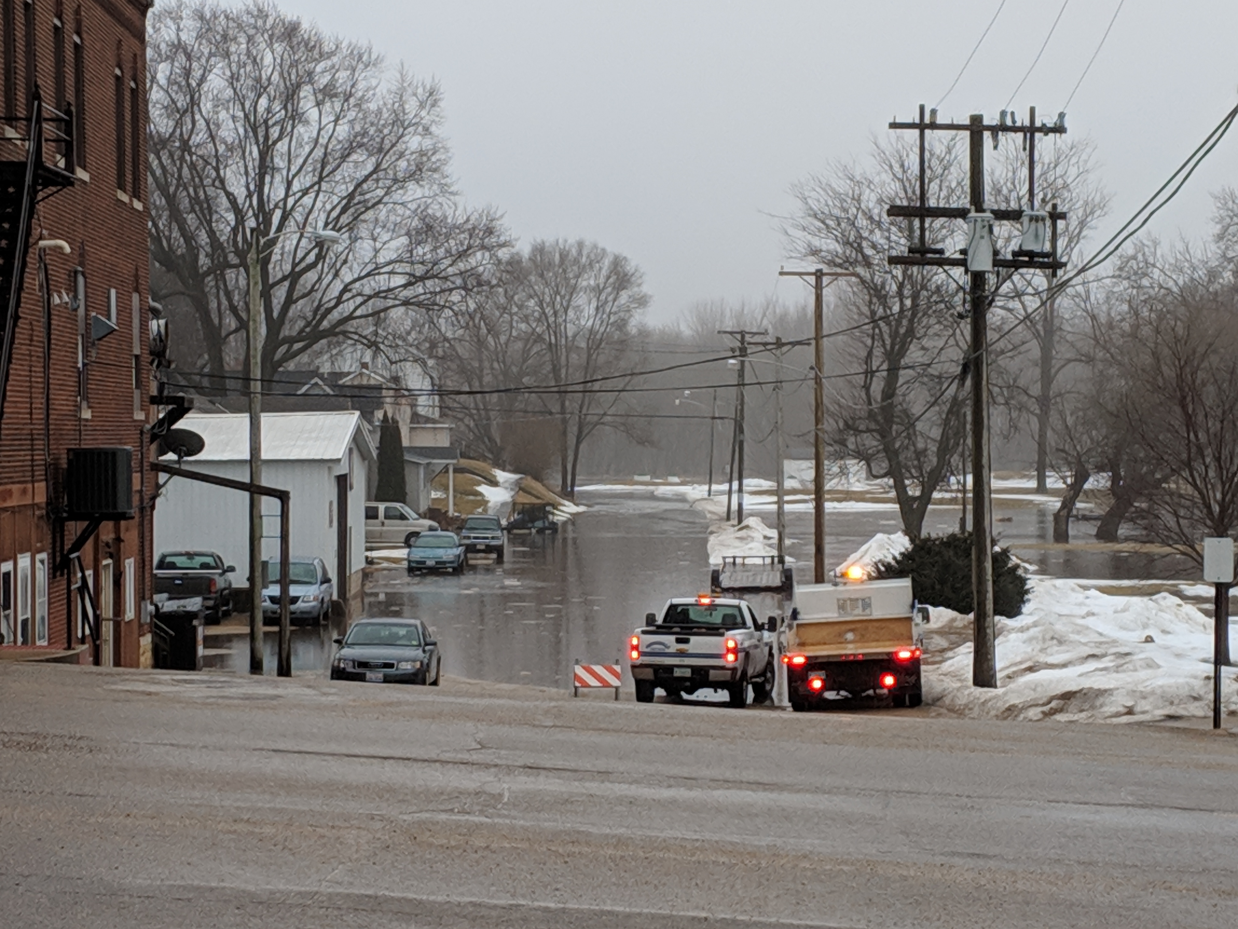
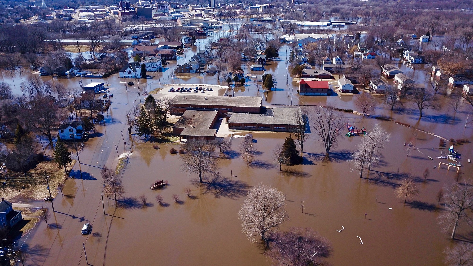
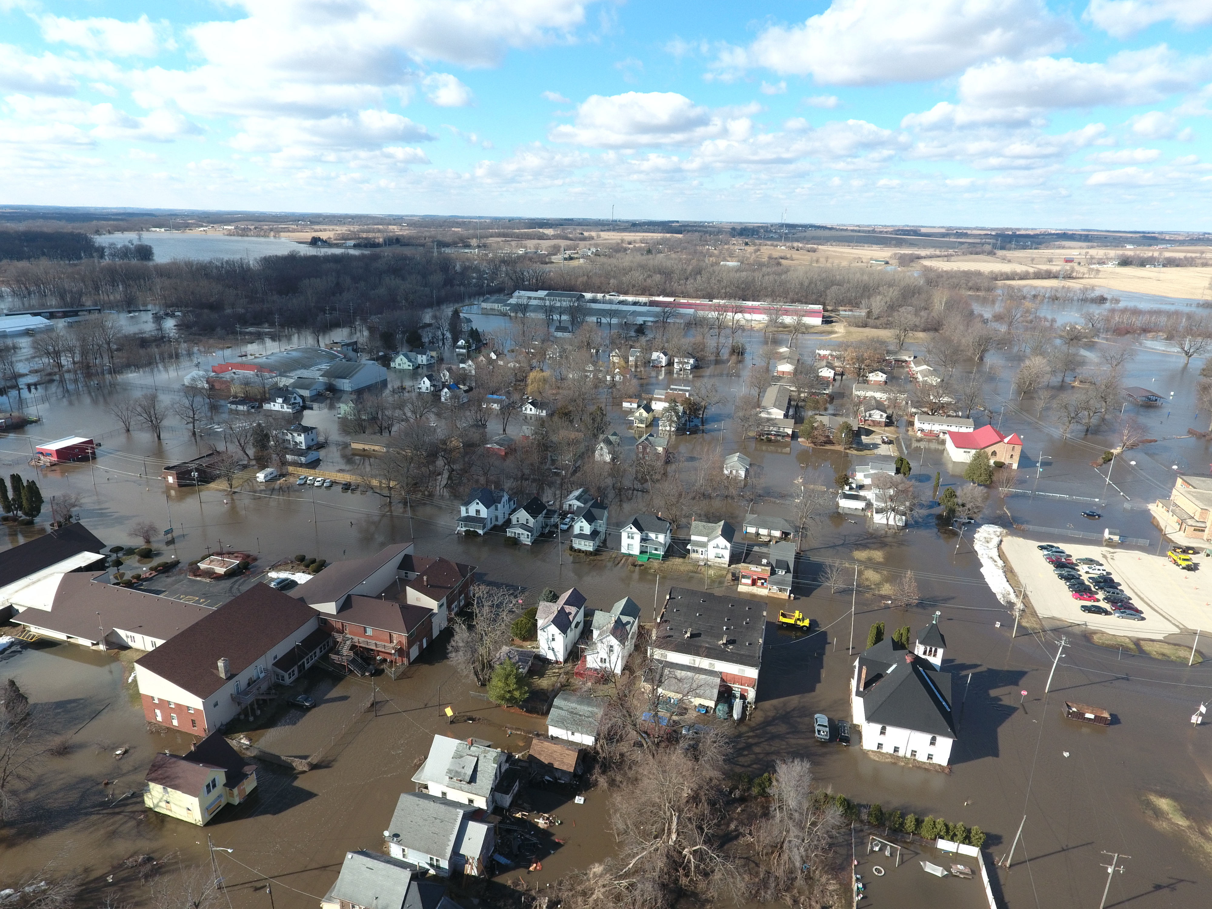
Significant flooding occurred across eastern Iowa, northwest Illinois, and northeast Missouri during Spring 2019. Moderate to Major flooding was observed on most Iowa and Illinois tributary rivers due to snowmelt, frozen ground, ice jams, saturated soils, and rainfall from March 9th-12th and again in late April/early May. The higher crests occurred on the Rock and Pecatonica Rivers in Illinois, and on the Skunk, English, Cedar, Wapsipinicon, and Maquoketa Rivers in Iowa. Most of these rivers crested during the 2nd and 3rd weeks of March and again in early May. Significant flooding also occurred on the mainstem Mississippi largely due to the snowmelt in Minnesota and Wisconsin, frozen ground, rainfall in early March, and saturated soils. Major flooding was observed at all sites along the Mississippi and ALL sites saw one of their top 5 crests on record. The Quad Cities river gauge at Rock Island Lock and Dam, broke its all-time record flood crest in 1993, with a preliminary crest of 22.70 ft. This flooding had numerous impacts, with many roads, businesses, homes, and people affected.
|
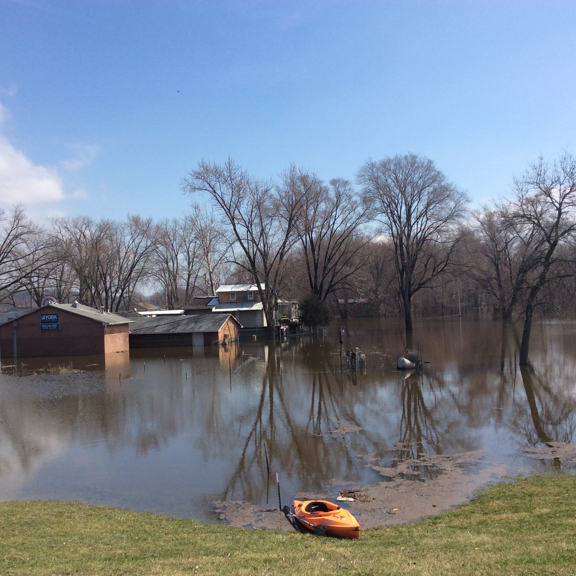
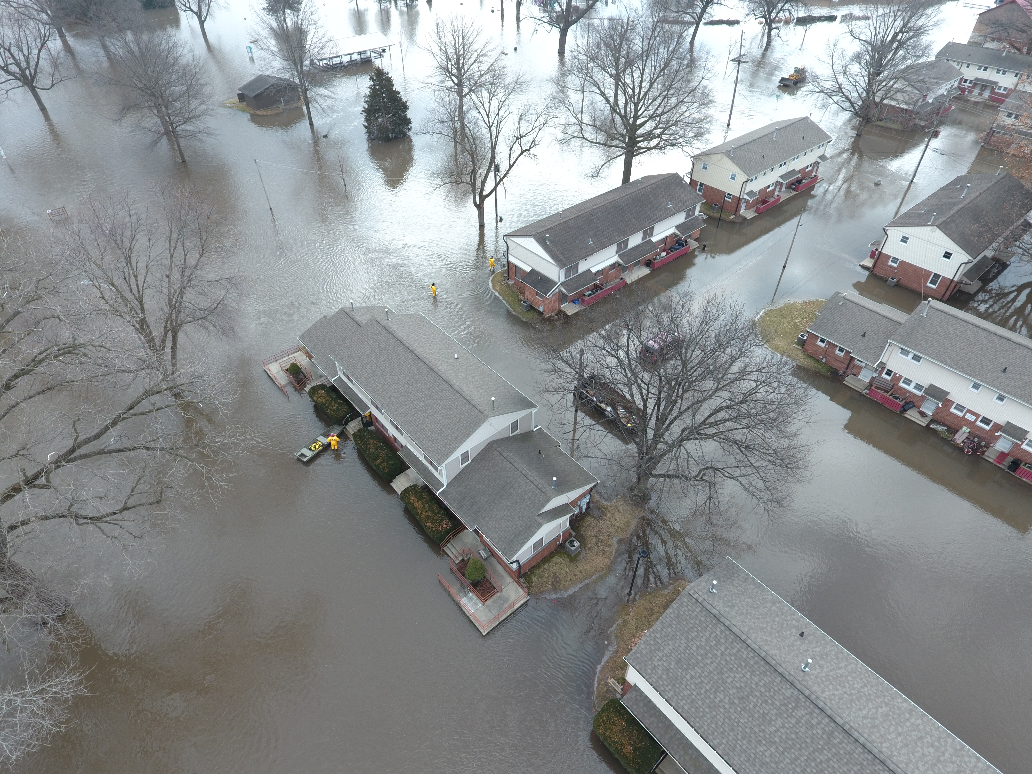
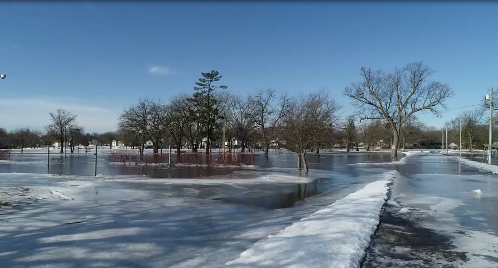
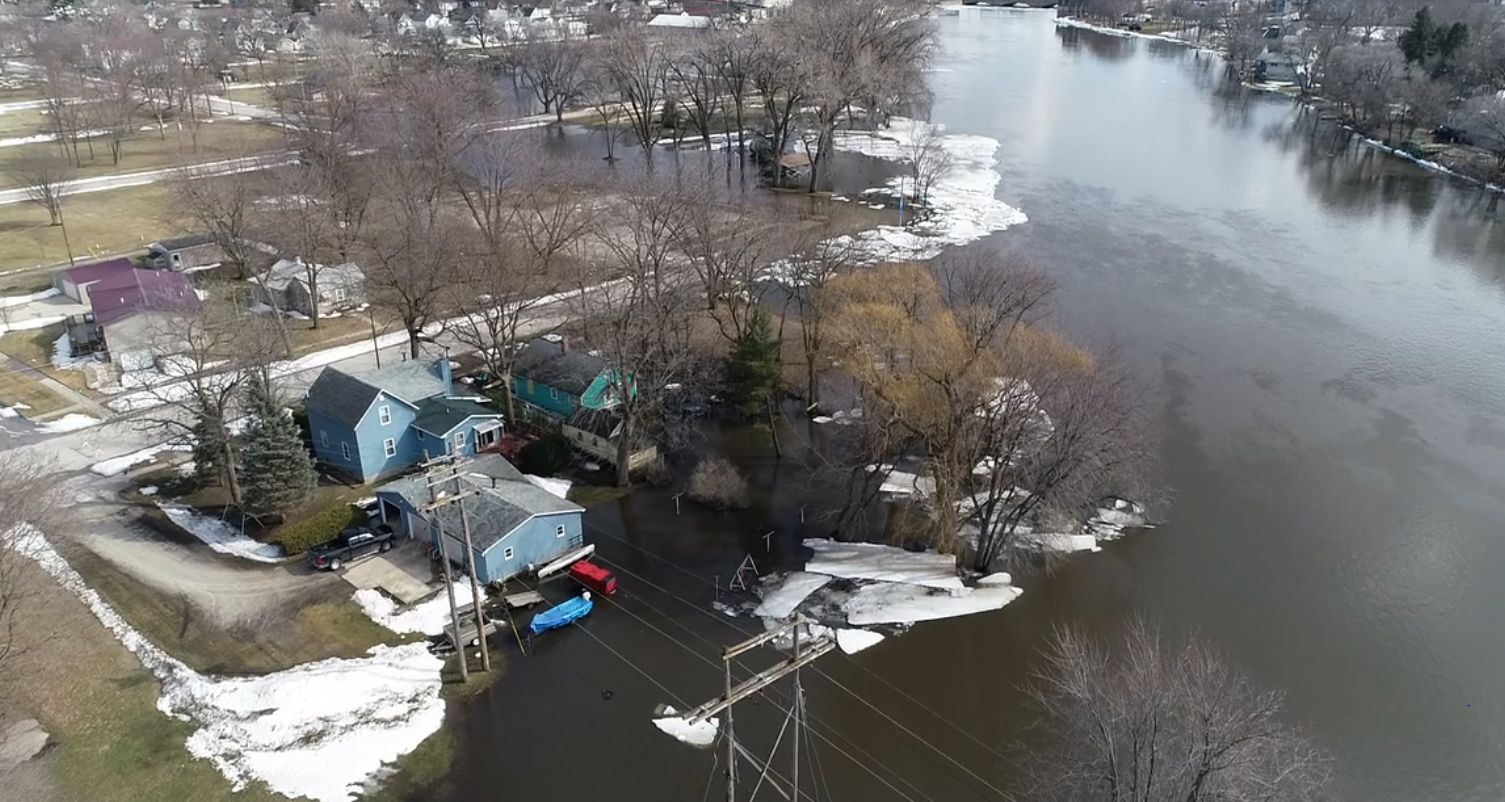
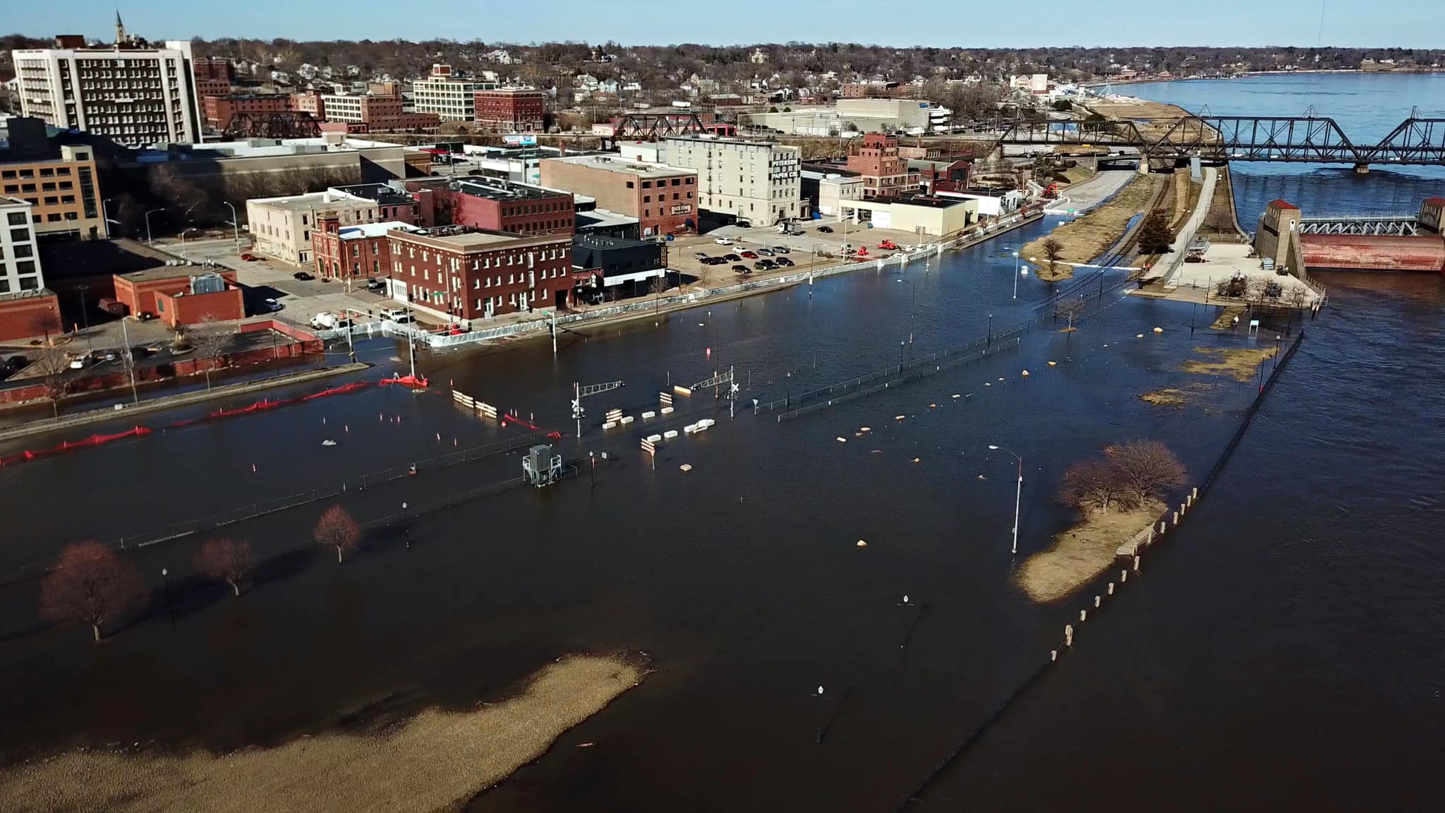 Mississippi River on 3/25/19 - Davenport, IA Photo: Steve Toft (QC Drone) |
 |
 |
|
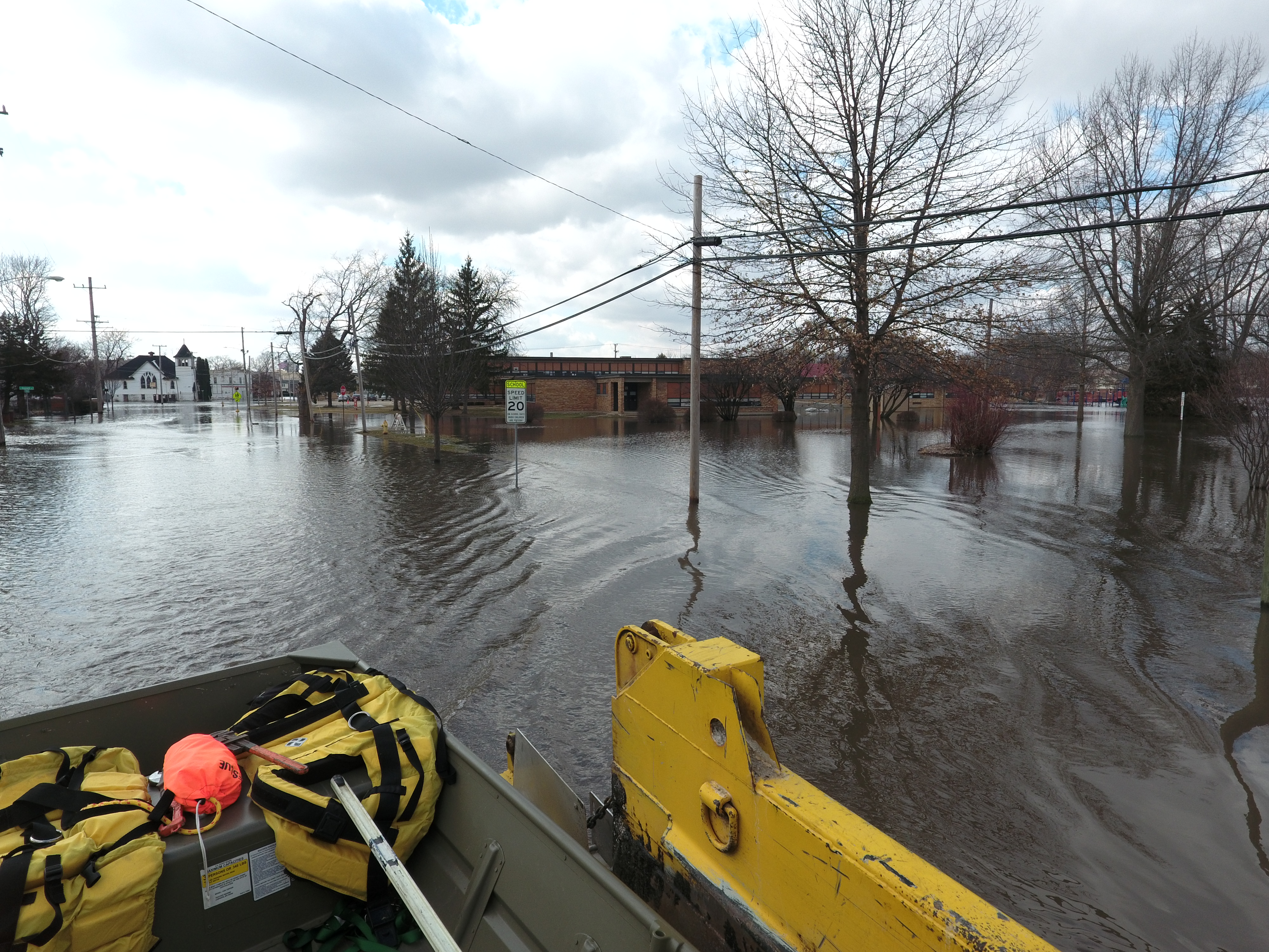
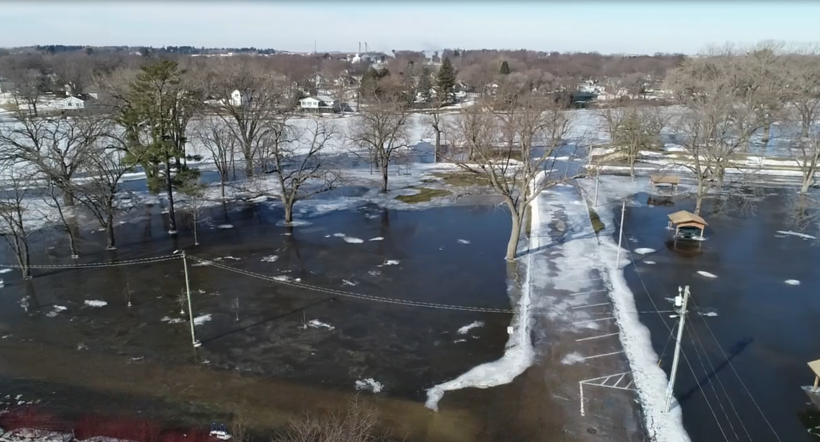
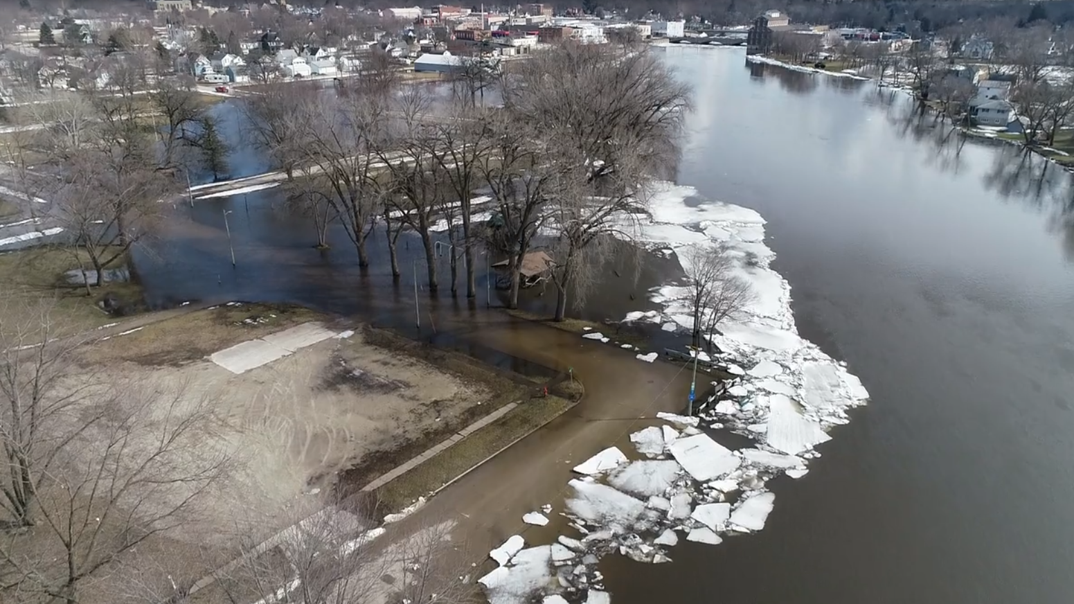
| Mississippi River Flooding in Davenport IA - March 25th Video: Steve Toft (QC Drone) |
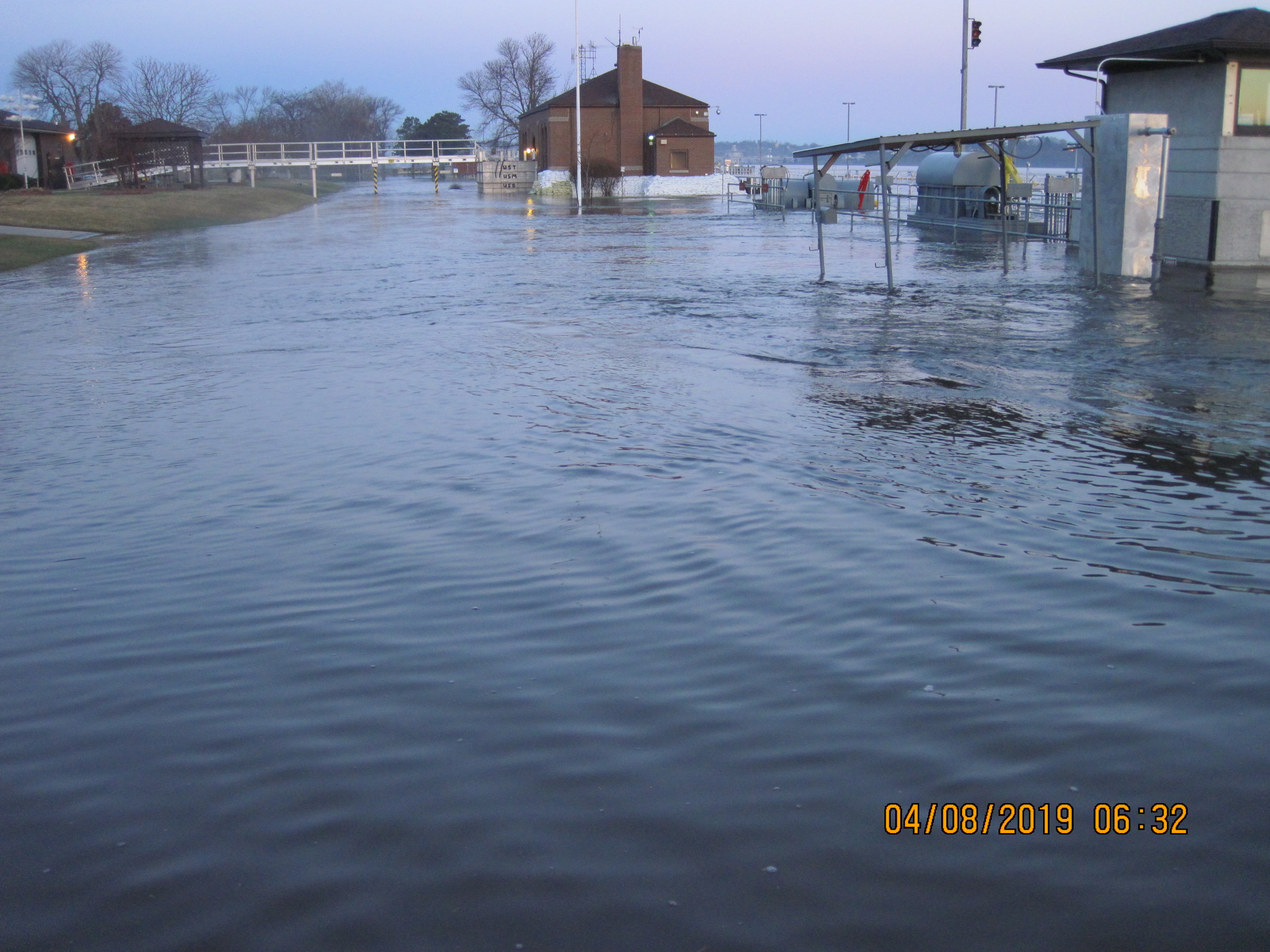
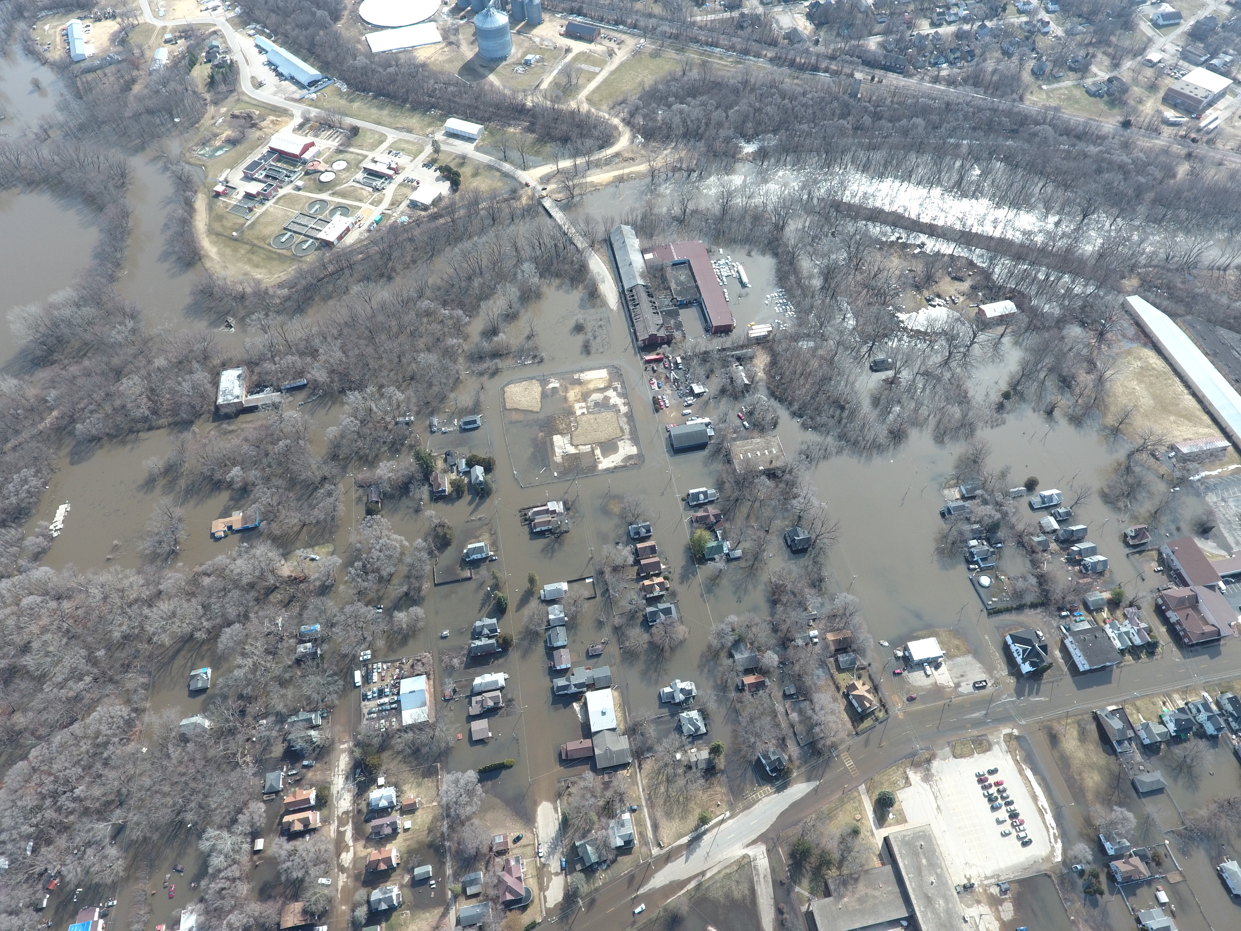
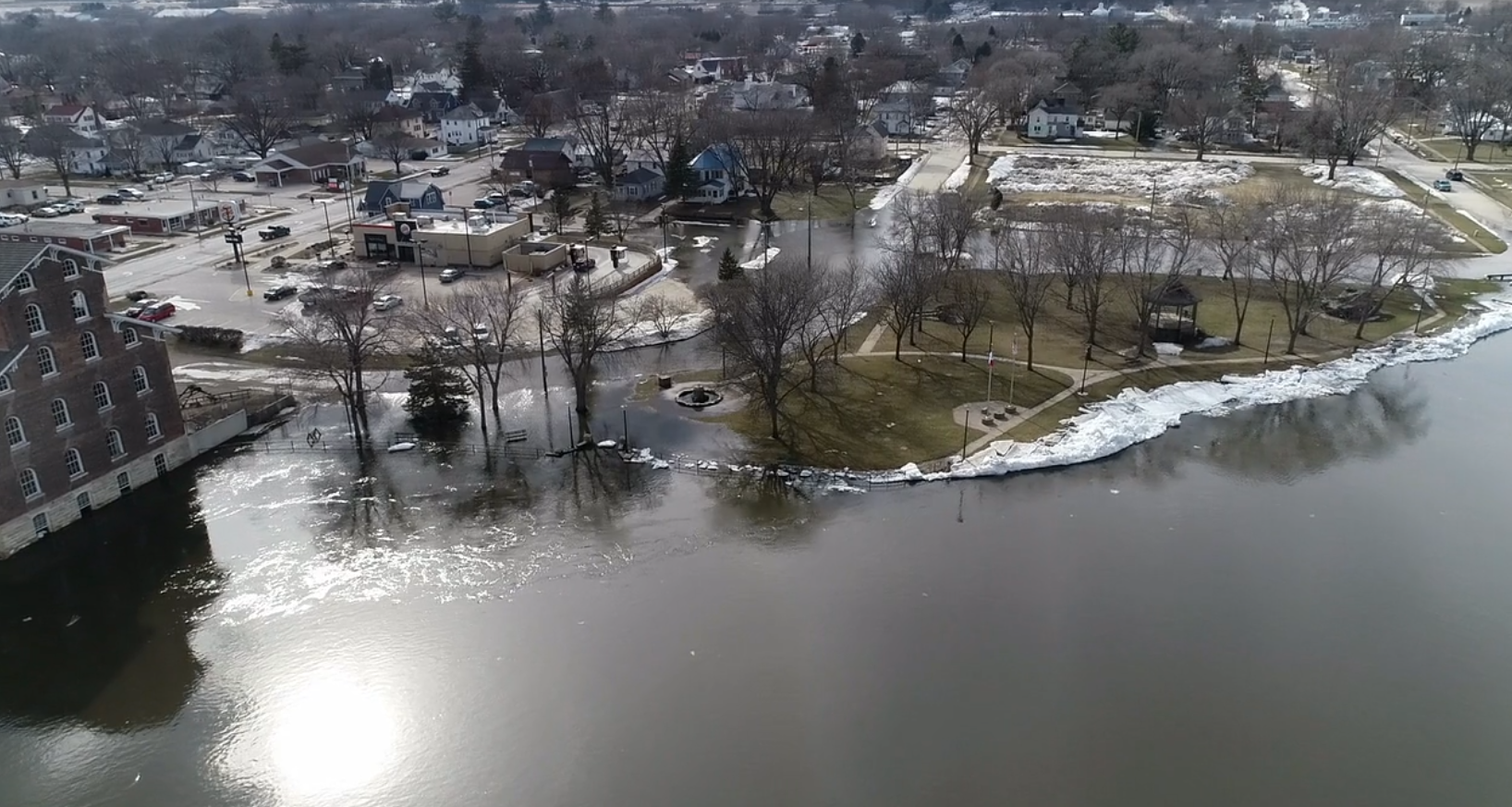
Illinois City Lock and Dam 16 - April 8th Photo: Nick Schnerre |
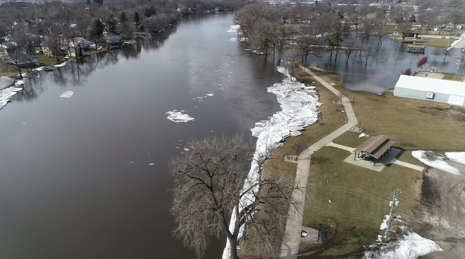
Freeport IL - March 17th Photo: Stephenson County EMA |
Flooding
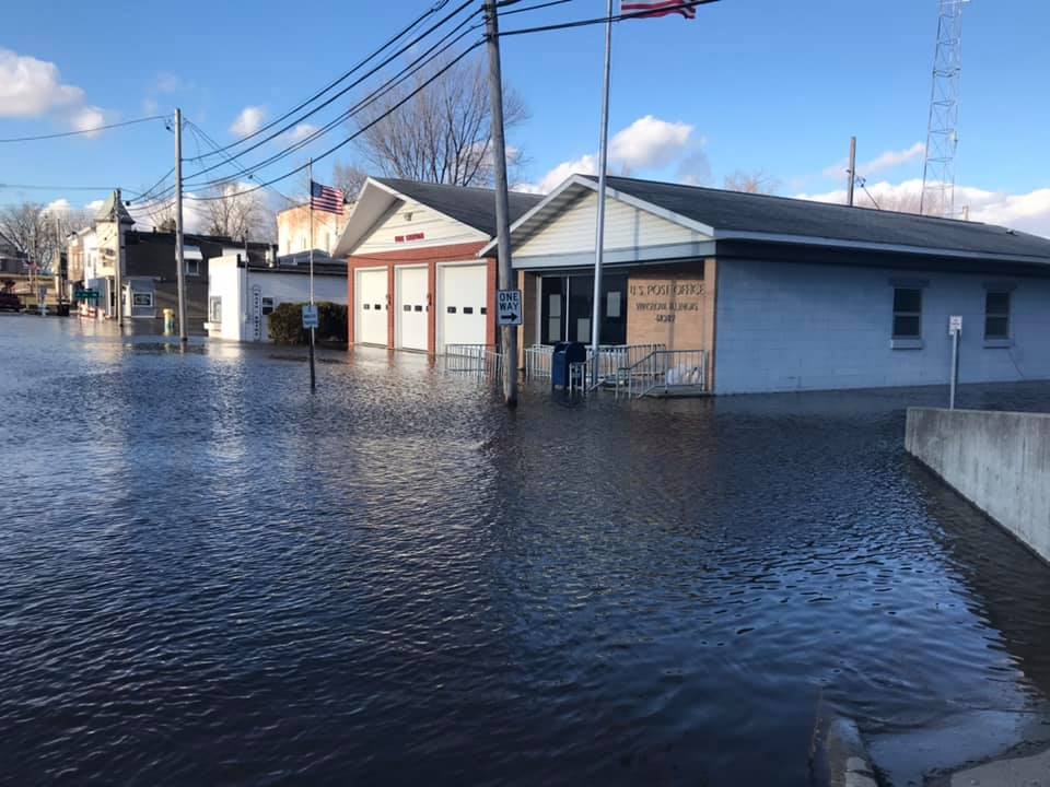
All rivers in eastern Iowa, northwest Illinois, and northeast Missouri experienced flooding in the Spring, with many sites seeing moderate to major flooding. The Rock River experienced its highest levels since 2013; Cedar River highest levels since 2016; and the Maquoketa River highest levels since 2014. Many sites on the tributary rivers saw a Top 10 crest on record. The mainstem Mississippi saw its highest levels since 2014 and all points had a Top 5 crest. All data is preliminary until verified by the USGS and USACE. The Mississippi River in the Quad Cities also had a temporary levee breach on April 30th, which resulted in many businesses, parking lots, and cars becoming overwhelmed with rising water. Click here for a write up of this breach.
Jump to River: Mississippi Wapsipinicon Cedar Iowa English Skunk Des Moines Pecatonica Rock Green La Moine
 |
 |
||
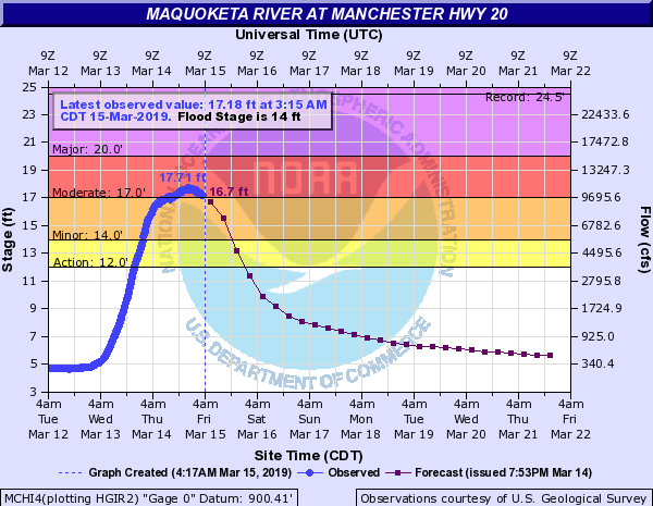
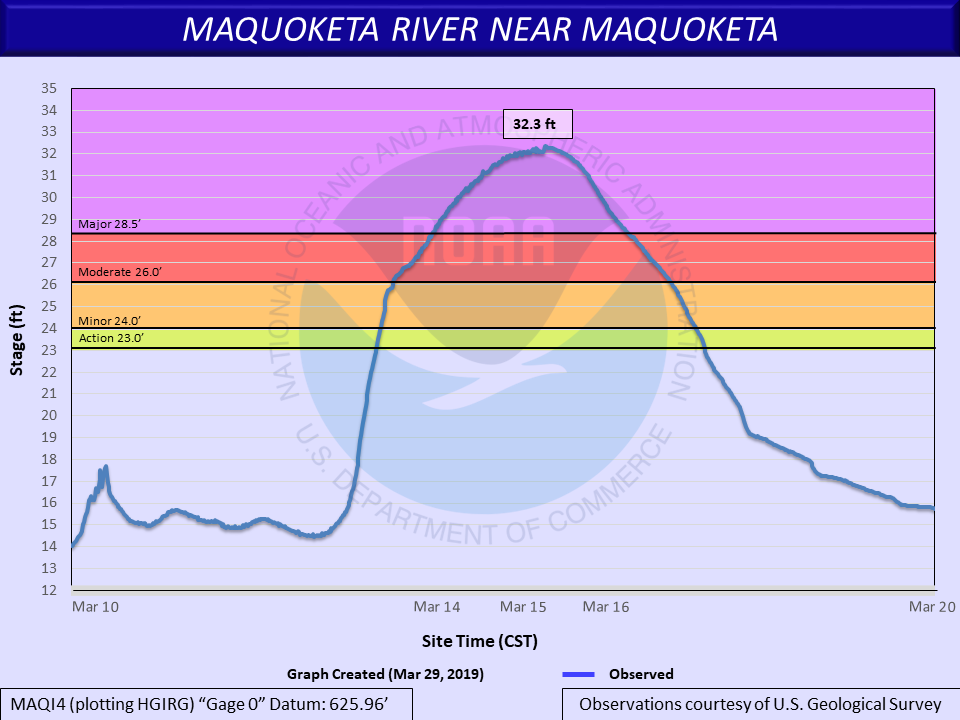
| Manchester | Maquoketa |
 |
 |
 |
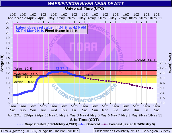 |
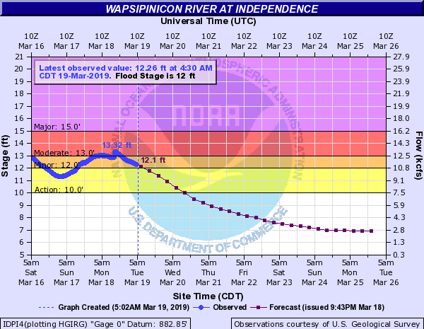
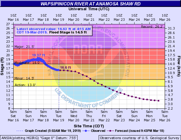
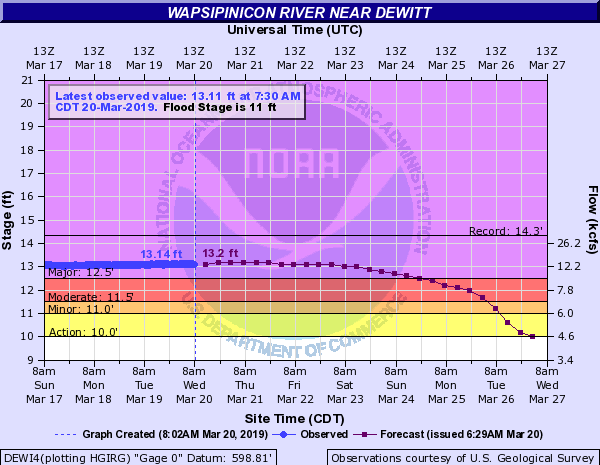
| Independence | Anamosa | De Witt - Early April | De Witt - Early May |
 |
 |
 |
 |
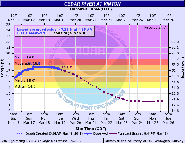
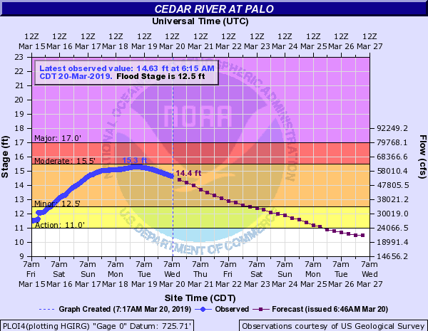
| Vinton | Palo | Cedar Rapids | Cedar Bluff |
 |
|||
| Conesville |
 |
 |
.png) |
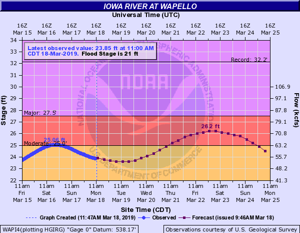 |
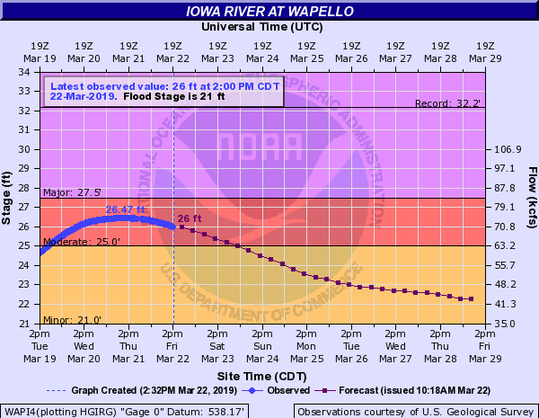
| Marengo | Lone Tree | Columbus Jct | Wapello Crest #1 |
 |
 |
 |
 |
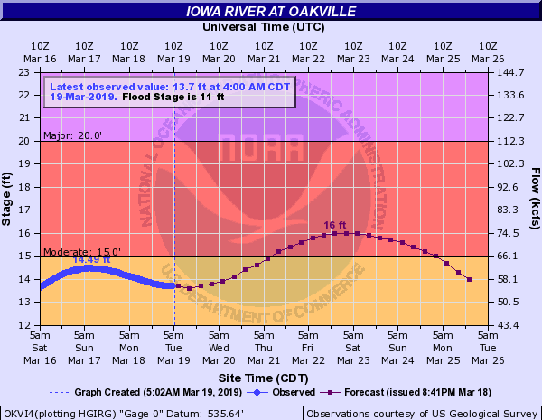
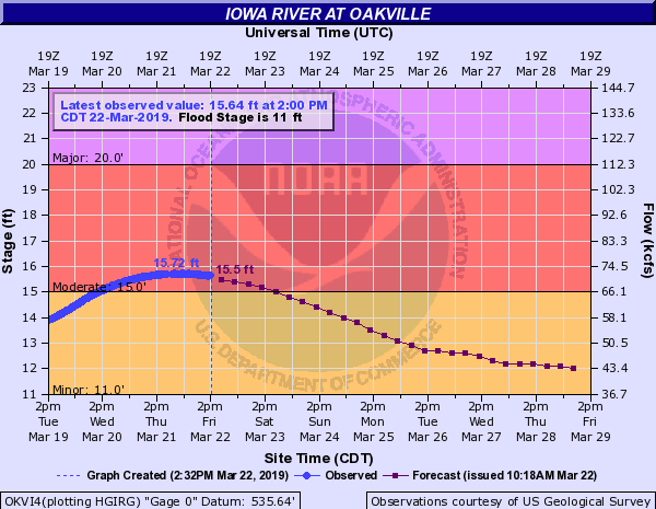
| Wapello Crest #2 | Oakville Crest #1 | Oakville Crest #2 | Oakville - Early May |
 |
|||
| Kalona |
 |
 |
 |
 |
| Sigourney | Augusta Crest #1 | Augusta Crest #2 | Augusta - Early May |
 |
 |
||
| St. Francisville | St. Francisville - Early May |
 |
|||
| Freeport |
 |
 |
 |
 |
| Como | Joslin | Joslin - Early May | Moline |
 |
|||
| Moline - Early May |
 |
|||
| Geneseo - Early May |
 |
|||
| Colmar - Early May |
Highest Crest occurred in late April (see below for additional crests)
 |
 |
 |
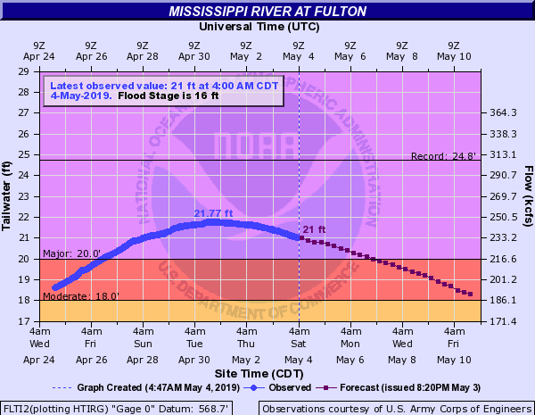 |
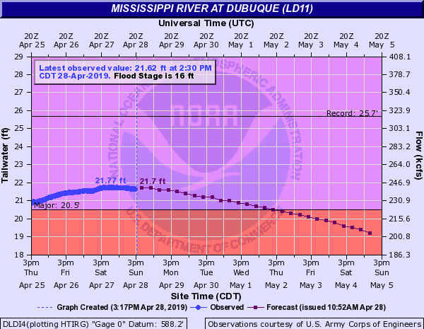
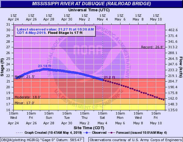
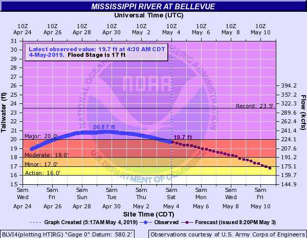
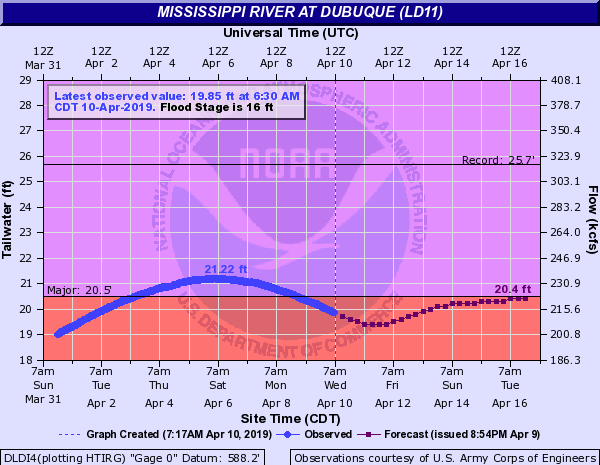
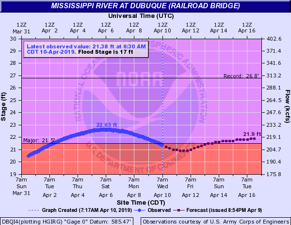
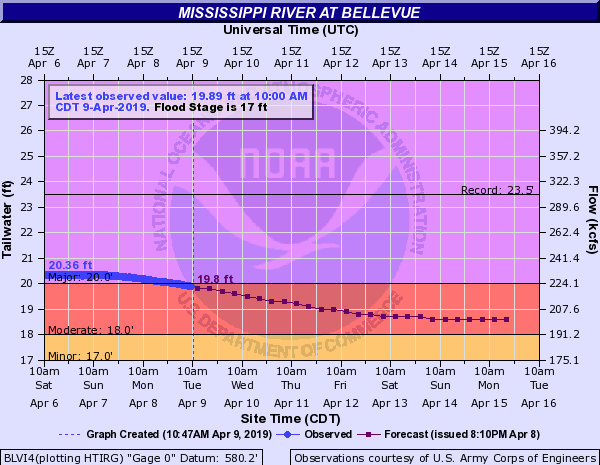
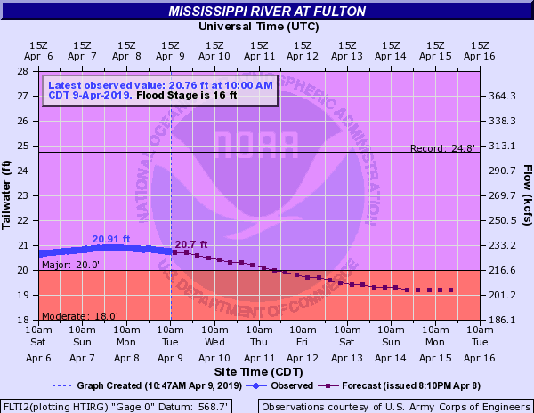
| Dubuque LD 11 | Dubuque Railroad Bridge | Bellevue LD 12 | Fulton LD 13 |
 |
 |
 |
 |
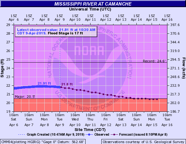
| Camanche | Le Claire LD 14 | Rock Island LD 15 | Illinois City LD 16 |
 |
 |
 |
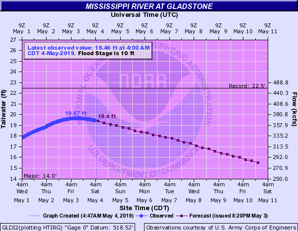 |
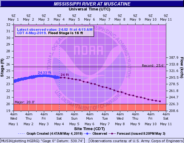
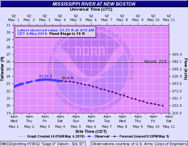
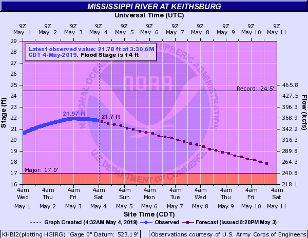
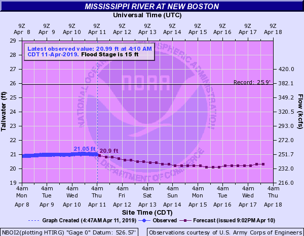
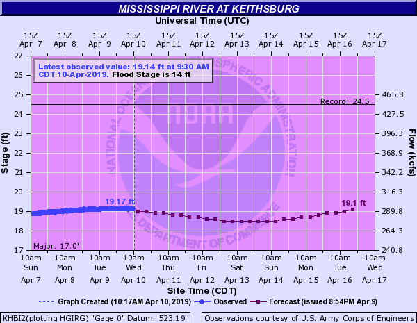
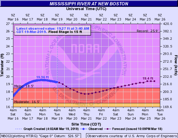
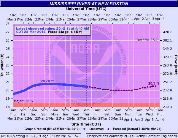
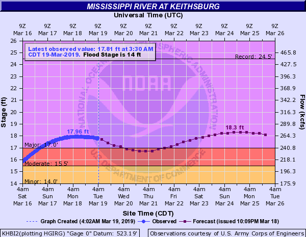
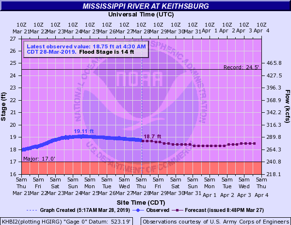
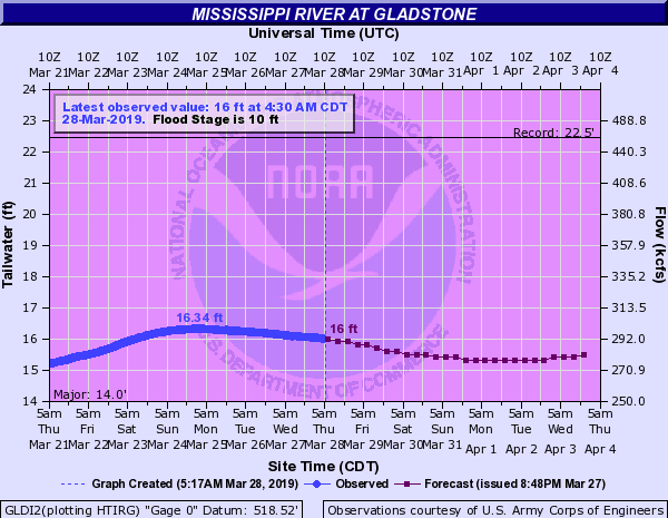
| Muscatine | New Boston LD 17 | Keithsburg | Gladstone LD 18 |
 |
 |
 |
|
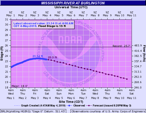
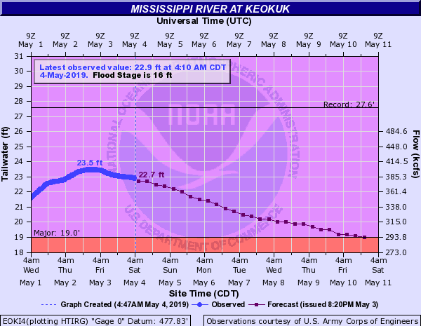
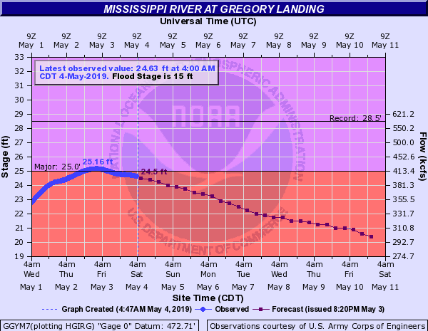
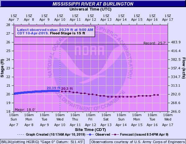
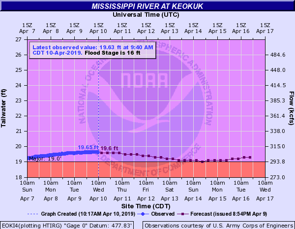
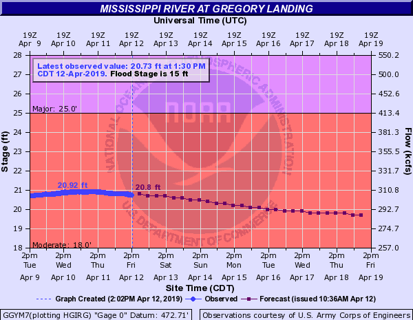
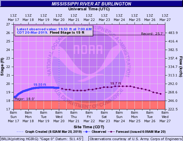
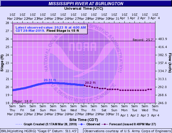
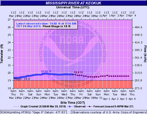
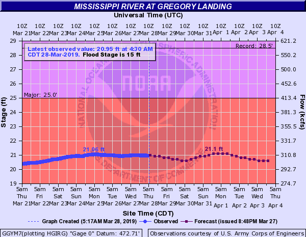
| Burlington | Keokuk LD 19 | Gregory Landing |
Secondary Crests
 |
 |
 |
 |
| Dubuque LD 11 - Early April | Dubuque Railroad Bridge - Early April | Bellevue LD 12 - Early April | Fulton LD 13 - Early April |
 |
 |
 |
 |
| Camanche - Early April | Le Claire LD 14 - Early April | Rock Island LD 15 - Early April | Illinois City LD 16 - Early April |
 |
 |
 |
 |
| Muscatine - Early April | New Boston LD 17 - Early April | Keithsburg - Early April | Gladstone LD 18 - Early April |
 |
 |
 |
|
| Burlington - Early April | Keokuk LD 19 - Early April | Gregory Landing - Early April | |
 |
 |
 |
 |
| Le Claire LD 14 - Crest 1 | Rock Island LD 15 - Crest 1 | Rock Island LD 15 - Crest 2 | Illinois City LD 16 - Crest 1 |
 |
 |
 |
 |
| Illinois City LD 16 - Crest 2 | Muscatine - Crest 1 | Muscatine - Crest 2 | New Boston LD 17 - Crest 1 |
 |
 |
 |
 |
| New Boston LD 17 - Crest 2 | Keithsburg - Crest 1 | Keithsburg - Crest 2 | Gladstone - Crest 1 |
 |
 |
 |
 |
| Burlington - Crest 1 | Burlington - Crest 2 | Keokuk LD 19 - Crest 1 | Gregory Landing - Crest 1 |
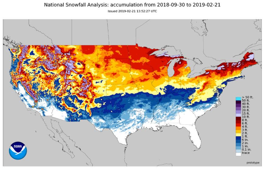
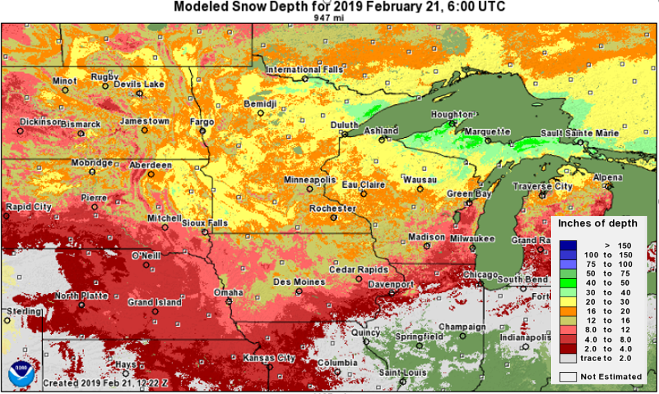
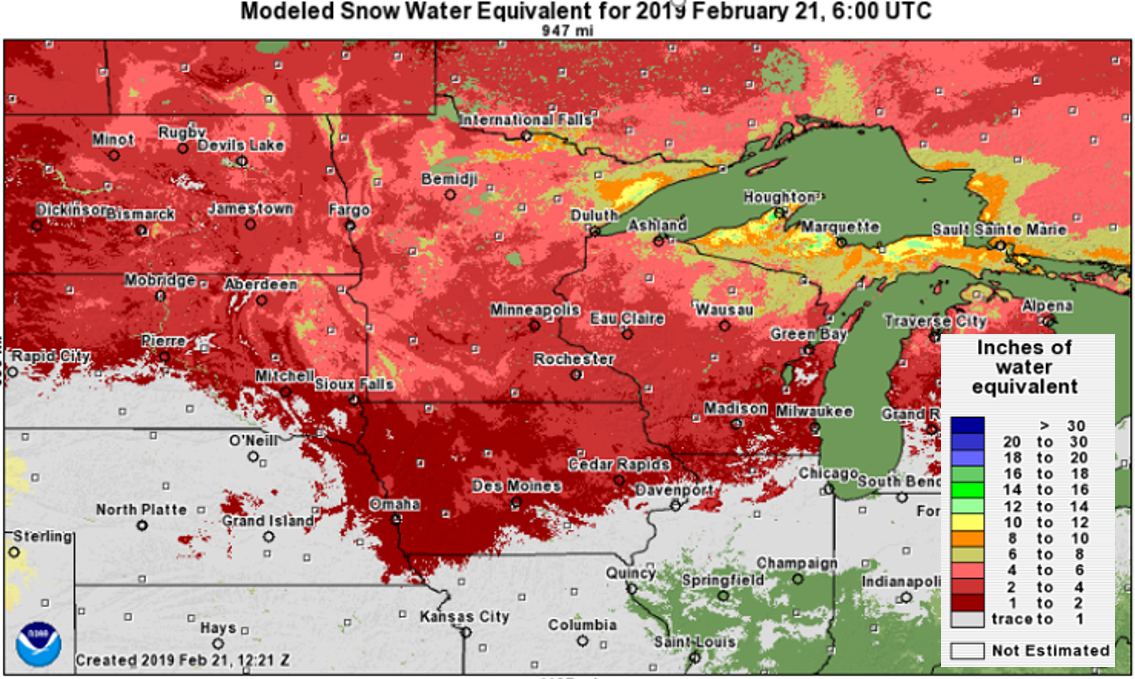
Factors that led to major and historic flooding:
 |
 |
 |
|
| Winter 2018-2019 Snowfall Analysis | February 21st, 2019 Snow Depth | February 21st, 2019 Snow Water Equivalent | |
 |
 |
 |
|
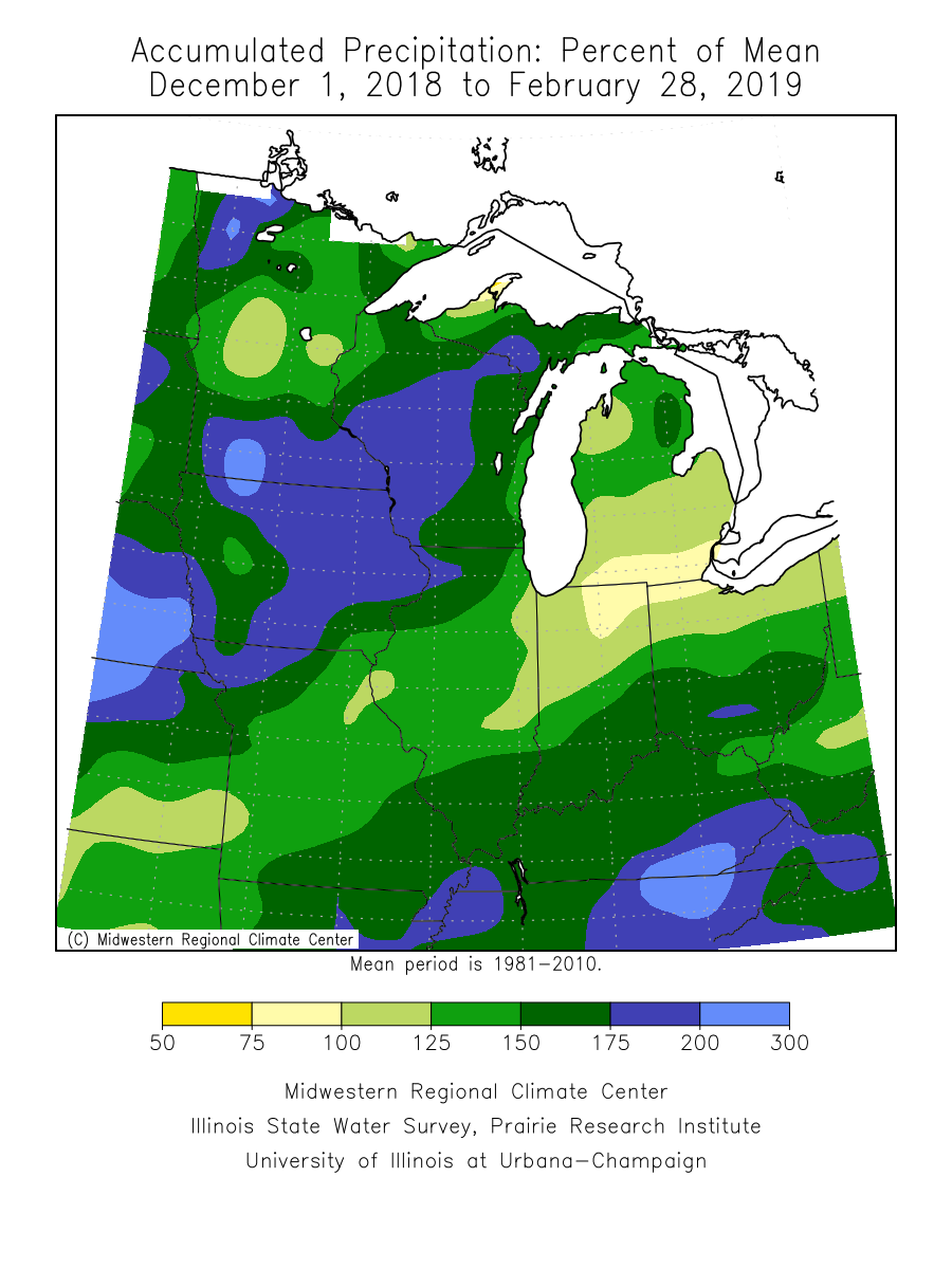
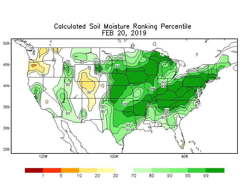
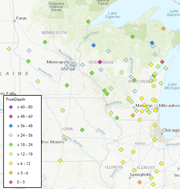
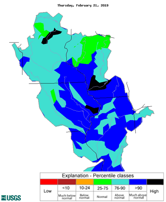
| December 1st, 2018 - February 28st, 2019 Accumulated Precipitation Percent of Mean | February 20th, 2019 Soil Moisture Percentile | February 21st, 2019 Frost Depth | |
 |
 |
 |
|
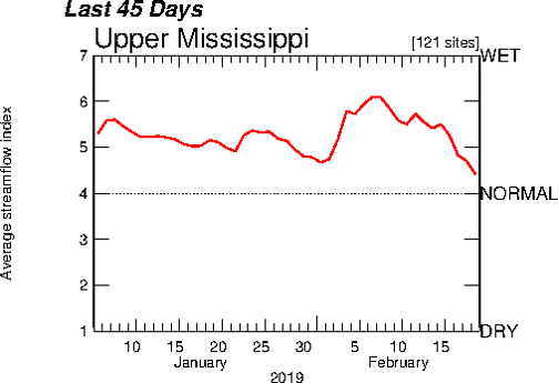
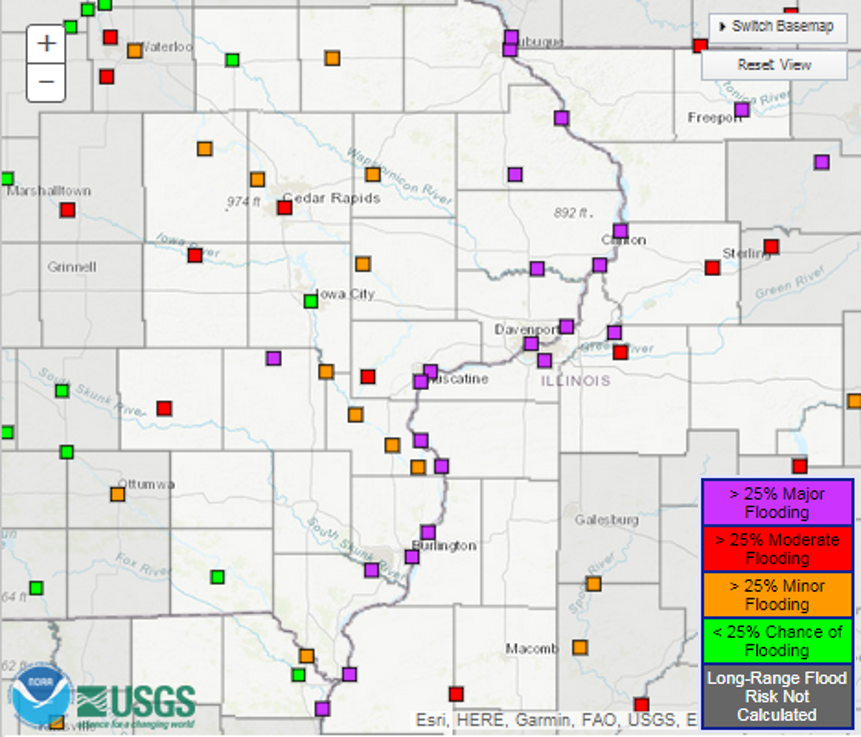
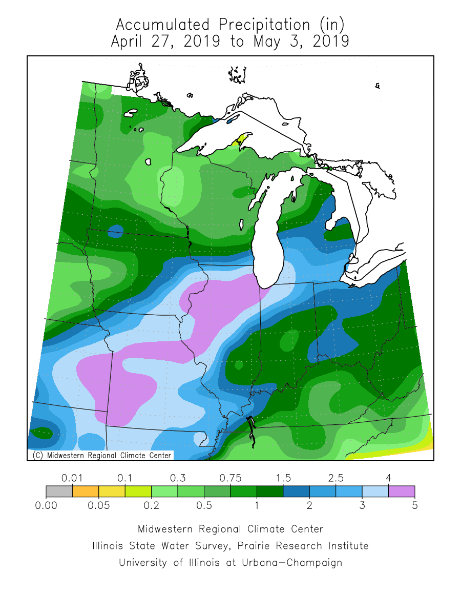
| February 21st, 2019 Streamflow - Courtesy USGS | Average Streamflow on Upper Mississippi last 45 days | Probabilisitc Flood Outlook - >25% chance of exceeding flood level | |
 |
|||
| Heavy Rain April 27th - May 3rd, 2019 | |||
| Links | |||
|
|
Photos & Video
Mississippi River
 |
 |
 |
 |
| Dubuque, IA (NWS Survey) |
Princeton, IA (NWS Survey) |
LeClaire, IA (NWS Survey) |
LeClaire, IA (NWS Survey) |
 |
 |
 |
 |
| Davenport, IA (NWS Survey) |
Davenport, IA (NWS Survey) |
Davenport, IA (NWS Survey) |
Davenport, IA Concord St (NWS Survey) |
Pecatonica River
 |
 |
 |
 |
| McConnell. IL (Photo: Stephenson County EMA) |
Orangeville, IL (Photo: Stephenson County EMA) |
Winslow, IL (Photo: Stephenson County EMA) |
Freeport, IL (Photo: Stephenson County EMA) |
 |
 |
 |
 |
| Freeport, IL (Photo: Lt. Tom Korte) |
Freeport, IL (Photo: Lt. Tom Korte) |
Freeport, IL (Photo: Lt. Tom Korte) |
Freeport, IL (Photo: Lt. Tom Korte) |
Iowa River
 |
|||
| Koszta, IA (Photo: Iowa County EMA) |
Wapsipinicon River
 |
 |
 |
 |
| Teachers Park - Independence, IA (Buchanan county EMA) |
Teachers Park - Independence, IA (Buchanan county EMA) |
Independence, IA (Buchanan county EMA) |
Independence, IA (Buchanan county EMA) |
 |
 |
 |
|
| Independence, IA (Buchanan county EMA) |
Independence, IA (Buchanan county EMA) |
210th St Wintrop, IA (Buchanan county EMA) |
Crest Information
| Summary of Area Rivers | ||||
| River | Location | Flood Stage | Record Stage | Actual Crest (Preliminary) |
| Mississippi River | Dubuque LD 11 (DLDI4) | 16.0 ft | 25.69 ft on 04/26/1965 | 21.77 ft. on 04/27/2019 (4th highest crest on record) |
| 21.22 ft. on 04/06/2019 (tied for 9th highest crest on record) |
||||
| Dubuque (DBQI4) | 17.0 ft | 26.81 ft on 04/26/1965 | 23.18 ft. on 04/27/2019 (4th highest crest on record) |
|
| 22.65 ft. on 04/06/2019 (tied for 9th highest crest on record) |
||||
| Bellevue LD12 (BLVI4) | 17.0 ft | 23.51 ft on 04/26/1965 | 20.87 ft. on 04/29/2019 (4th highest crest on record) |
|
| 20.36 ft. on 04/06/2019 (5th highest crest on record) |
||||
| Fulton LD 13 (FLTI2) | 16.0 ft | 24.75 ft on 04/28/1965 | 21.77 ft. on 04/30/2019 (4th highest crest on record) |
|
| 20.91 ft. on 04/08/2019 (8th highest crest on record) |
||||
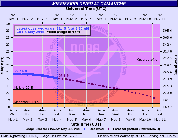
| Camanche (CMMI4) | 17.0 ft | 24.65 ft on 04/28/1965 | 22.77 ft. on 04/30/2019 (4th highest crest on record) |
|
| 21.91 ft. on 04/08/2019 (6th highest crest on record) |
||||
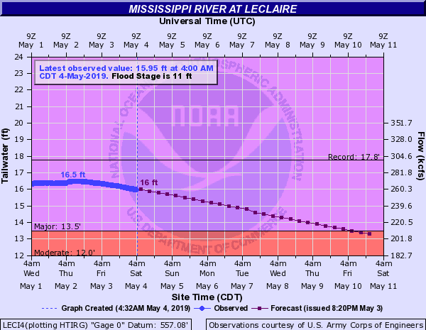
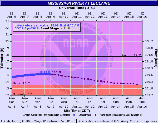
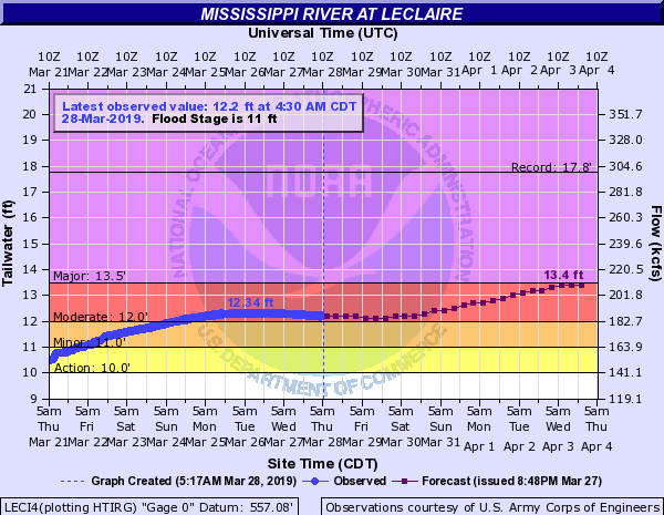
| Le Claire LD 14 (LECI4) | 11.0 ft | 17.75 ft on 04/28/1965 | 16.50 ft. on 05/02/2019 (4th highest crest on record) |
|
| 15.14 ft. on 04/08/2019 (5th highest crest on record) |
||||
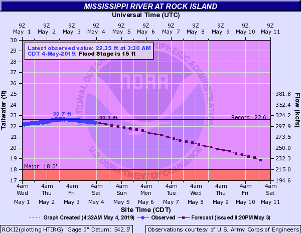
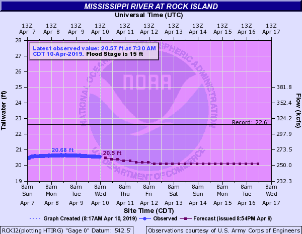
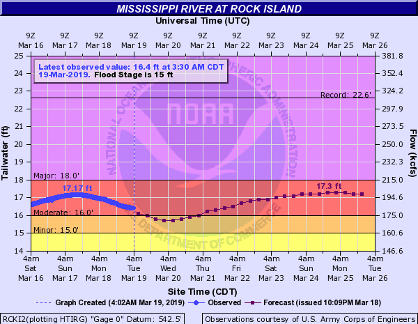
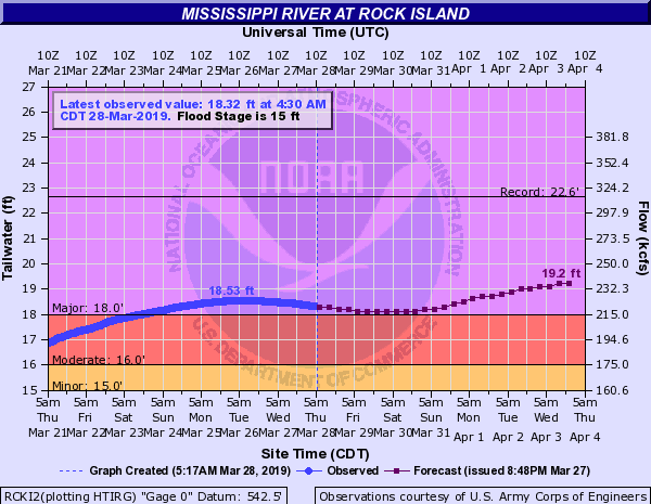
| Rock Island LD 15 (RCKI2) | 15.0 ft | 22.63 ft on 07/09/1993 | 22.70 ft. on 05/02/2019 (HIGHEST crest on record) |
|
| 20.68 ft. on 04/08/2019 (9th highest crest on record) |
||||
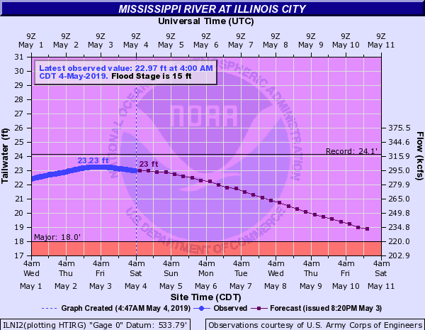
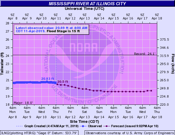
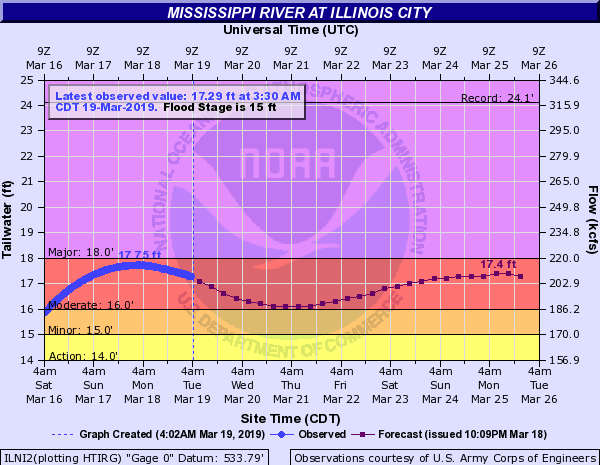
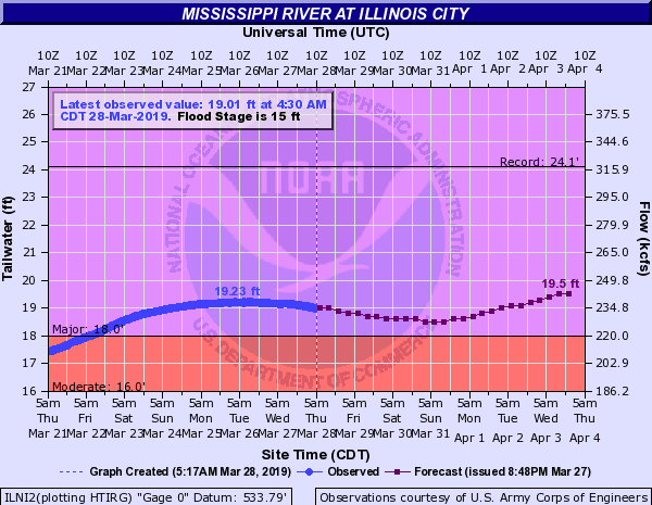
| Illinois City LD 16 (ILNI2) | 15.0 ft | 24.10 ft on 07/09/1993 | 23.23 ft. on 05/03/2019 (3rd highest crest on record) |
|
| 20.83 ft. on 04/10/2019 (6th highest crest on record) |
||||
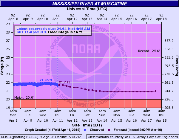
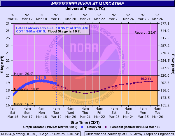
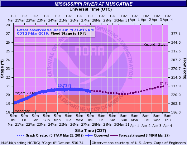
| Muscatine (MUSI4) | 16.0 ft | 25.61 ft on 07/09/1993 | 24.33 ft. on 05/03/2019 (4th highest crest on record) |
|
| 21.95 ft. on 04/10/2019 (7th highest crest on record) |
||||
| New Boston LD 17 (NBOI2) | 15.0 ft | 25.90 ft on 07/09/1993 | 23.59 ft. on 05/03/2019 (4th highest crest on record) |
|
| 21.04 ft. on 04/10/2019 (10th highest crest on record) |
||||
| Keithsburg (KHBI2) | 14.0 ft | 24.49 ft on 06/17/2008 | 21.97 ft. on 05/03/2019 (4th highest crest on record) |
|
| 19.17 ft. on 04/10/2019 (11th highest crest on record) |
||||
| Gladstone LD 18 (GLDI2) | 10.0 ft | 22.46 ft on 06/17/2008 | 19.67 ft. on 05/03/2019 (4th highest crest on record) |
|
| 16.30 ft. on 04/10/2019 (10th highest crest on record) |
||||
| Burlington (BRLI4) | 15.0 ft | 25.73 ft on 06/17/2008 | 23.54 ft. on 05/03/2019 (4th highest crest on record) |
|
| 20.41 ft. on 04/10/2019 (10th highest crest on record) |
||||
| Keokuk LD 19 (EOKI4) | 16.0 ft | 27.58 ft on 07/10/1993 | 23.50 ft. on 05/02/2019 (tied 3rd highest crest on record) |
|
| 19.78 ft. on 04/11/2019 | ||||
| Gregory Landing (GGYM7) | 15.0 ft | 28.49 ft on 07/09/1993 | 25.16 ft. on 05/03/2019 (3rd highest crest on record) |
|
| 20.92 ft. on 04/11/2019 | ||||
| Maquoketa River | Manchester (MCHI4) | 14.0 ft | 24.48 ft on 07/24/2010 | 17.71 ft. on 03/15/2019 (9th highest crest on record) |
| Maquoketa (MAQI4) | 24.0 ft | 35.26 ft on 07/26/2016 | 32.41 ft. on 03/15/2019 (4th highest crest on record) |
|
| Wapsipinicon River | Independence (IDPI4) | 12.0 ft | 22.35 ft on 05/18/1999 | 13.37 ft on 03/15/2019 |
| Anamosa (ANSI4) | 14.5 ft | 26.18 ft on 06/13/2008 | 19.37 ft. on 03/18/2019 (7th highest crest on record) |
|
| De Witt (DEWI4) | 11.0 ft | 14.32 ft on 07/02/2014 | 13.21 ft on 03/14/2019 | |
| Cedar River | Vinton (VINI4) | 15.0 ft | 24.70 ft on 06/12/2008 | 17.72 ft. on 03/17/2019 (9th highest crest on record) |
| Palo (PLOI4) | 12.5 ft | 23.22 ft on 06/13/2008 | 15.38 ft. on 03/18/2019 (4th highest crest on record) |
|
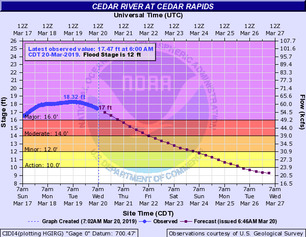
| Cedar Rapids (CIDI4) | 12.0 ft | 31.12 ft on 06/13/2008 | 18.32 ft. on 03/20/2019 (9th highest crest on record) |
|
| Cedar Bluff (CEBI4) | 16.0 ft | 24.70 ft on 09/28/2016 | 21.47 ft on 03/20/2019 | |
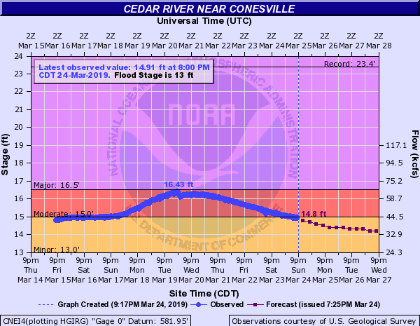
| Conesville (CNEI4) | 13.0 ft | 23.40 ft on 06/15/2008 | 16.43 ft. on 03/20/2019 | |
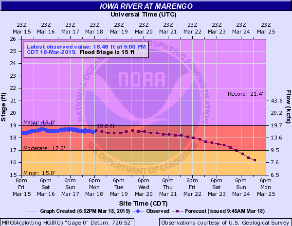
| Iowa River | Marengo (MROI4) | 15.0 ft | 21.38 ft on 06/12/2008 | 18.83 ft. on 03/17/2019 (10th highest crest on record) |
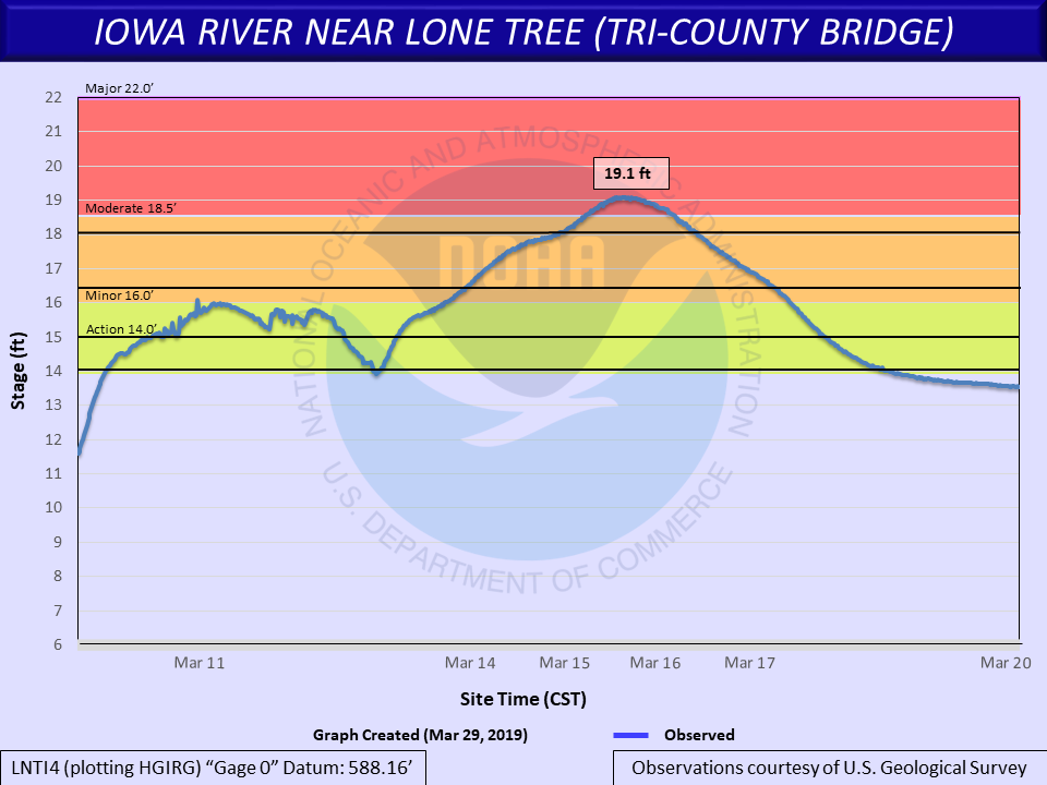
| Lone Tree (LNTI4) | 16.0 ft | 23.10 ft on 06/15/2008 | 19.10 ft. on 03/15/2019 (8th highest crest on record) |
|
| Columbus Junction (CJTI4) | 23.0 ft | 32.30 ft on 06/15/2008 | 24.21 ft. on 03/21/2019 (9th highest crest on record) |
|
| Wapello (WAPI4) | 21.0 ft | 32.15 ft on 06/14/2008 | 26.47 ft on 03/21/2019 | |
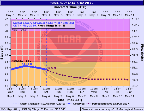
| Oakville (OKVI4) | 11.0 ft | 23.22 ft on 06/14/2008 | 15.72 ft on 03/22/2019 | |
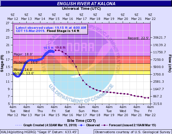
| English River | Kalona (KALI4) | 14.0 ft | 22.55 ft on 07/06/1993 | 19.89 ft on 03/15/2019 |
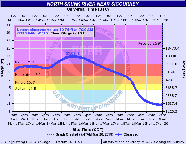
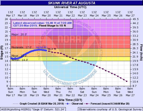
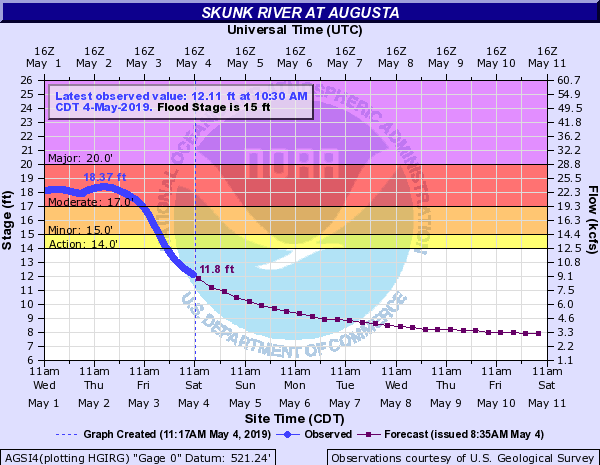
| Skunk River | Sigourney (SIGI4) | 16.0 ft | 25.93 ft on 05/28/2013 | 23.01 ft. on 03/16/2019 (9th highest crest on record) |
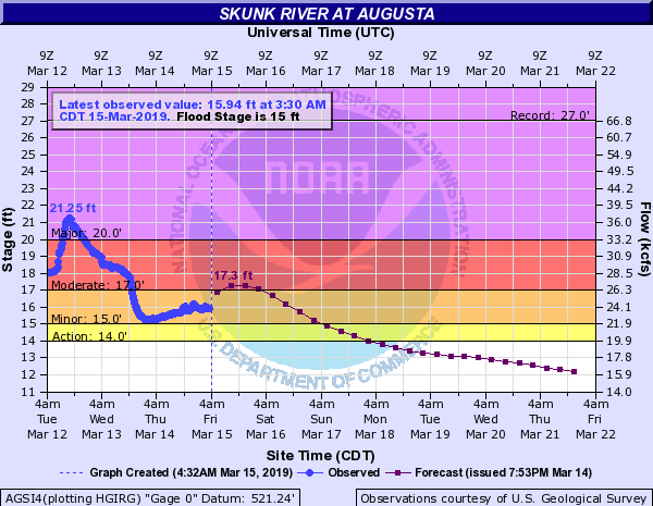
| Augusta (AGSI4) | 15.0 ft | 27.05 ft on 04/23/1973 | 21.37 ft on 03/12/2019 | |
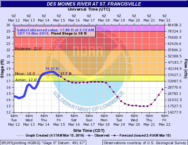
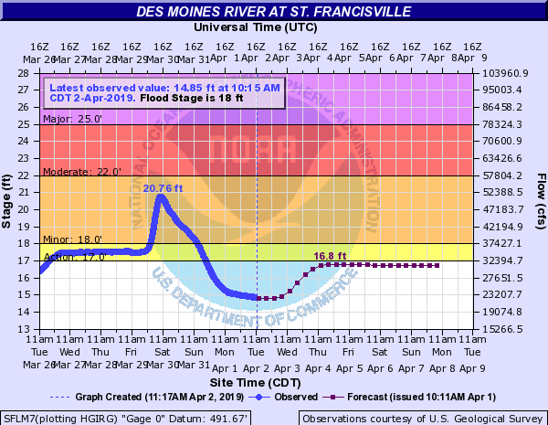
| Des Moines River | St. Francisville (SFLM7) | 18.0 ft | 32.02 ft on 07/15/1993 | 20.76 ft on 03/30/2019 |
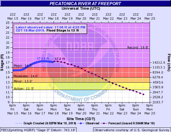
| Pecatonica River | Freeport (FEEI2) | 13.0 ft | 19.76 ft on 03/16/1929 | 17.26 ft. on 03/18/2019 (9th highest crest on record) |
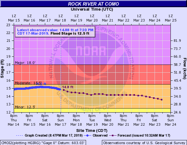
| Rock River | Como (CMOI2) | 12.5 ft | 15.65 ft on 07/23/2017 | 15.20 ft. on 03/16/2019 (2nd highest crest on record) |
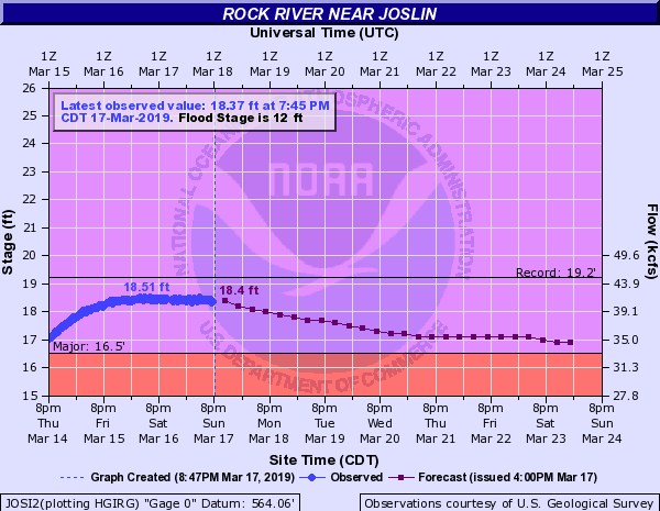
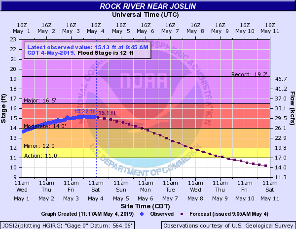
| Joslin (JOSI2) | 12.0 ft | 19.24 ft on 06/07/2002 | 18.51 ft. on 03/16/2019 (6th highest crest on record) |
|
| 15.22 ft. on 05/03/2019 | ||||
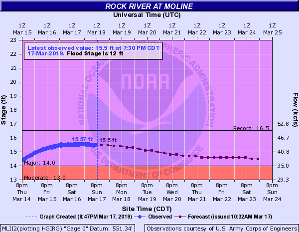
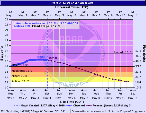
| Moline (MLII2) | 12.0 ft | 16.53 ft on 04/21/2013 | 15.72 ft. on 03/17/2019 (5th highest crest on record) |
|
| 15.36 ft. on 05/03/2019 (8th highest crest on record) |
||||
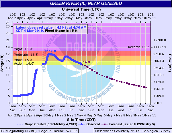
| Green River | Geneseo (GENI2) | 15.0 ft | 18.77 ft on 10/18/1998 | 17.12 ft. on 05/01/2019 (10th highest crest on record) |
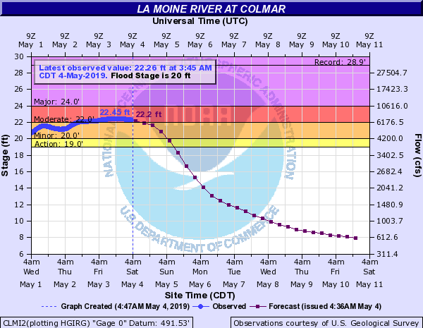
| La Moines River | Colmar (CLMI2) | 20.0 ft | 28.94 ft on 04/19/2013 | 22.45 ft. on 05/03/2019 |
River and streamflow information:
Flood safety and flood insurance information:
Precipitation, temperature, and soil moisture information:
 |
Media use of NWS Web News Stories is encouraged! Please acknowledge the NWS as the source of any news information accessed from this site. |
|