
Dangerous heat will expand from the Gulf Coast into the Southern Plains and Desert Southwest through week's end. Additional extreme heat impacting the Pacific Northwest will shift to the northern Plains by the weekend. Tropical Storm Bertha is expected to continue to impact portions of the northern Gulf Coast from the western Florida Panhandle to southeastern Louisiana through tonight. Read More >
|
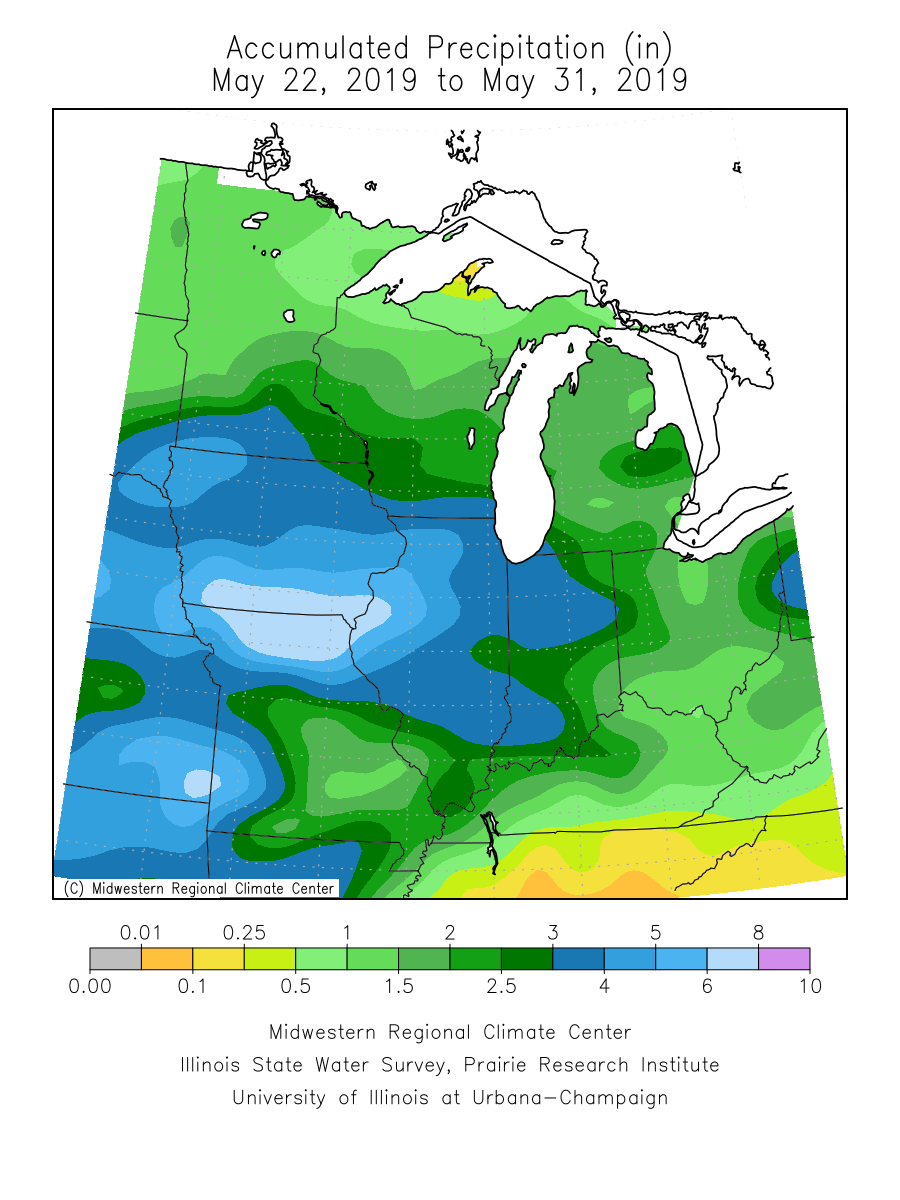
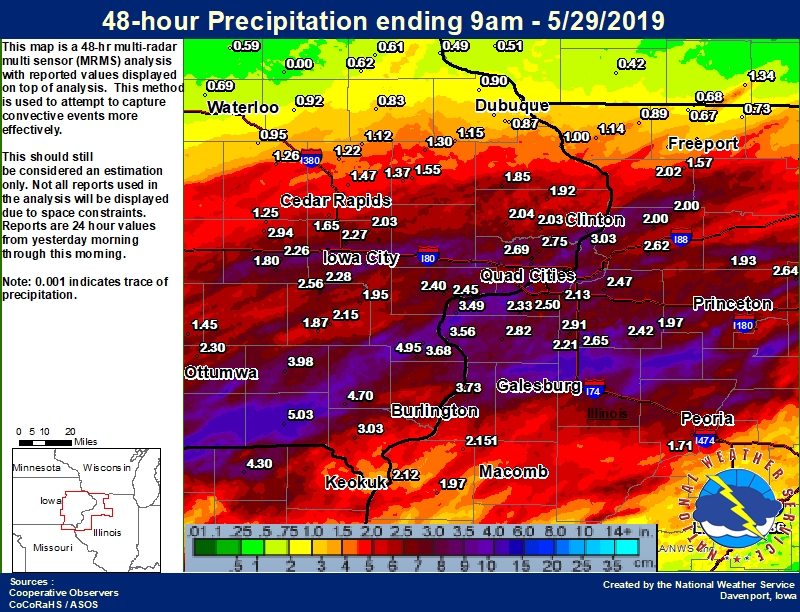
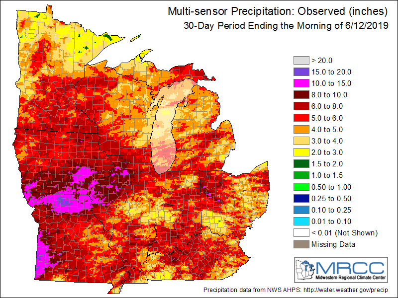
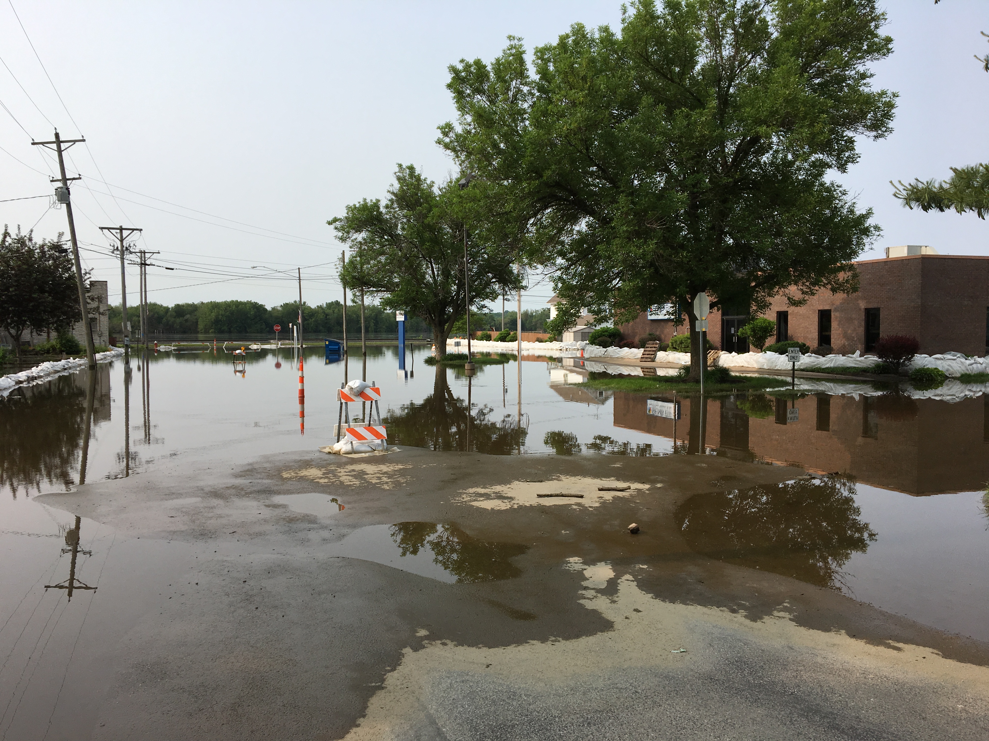
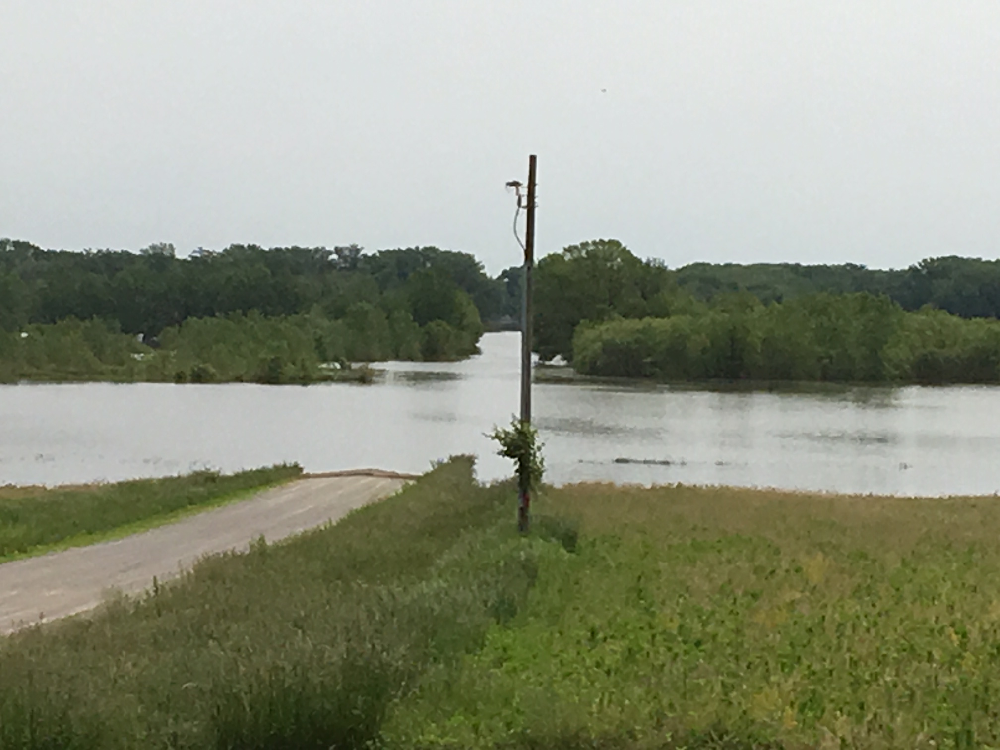
Extensive flooding occurred late May and into June across eastern Iowa, northwest Illinois, and northeast Missouri. The last half of May was very wet with 5-8 inches of rain falling over the region. This combined with saturated soils, brought many rivers above Moderate to Major flood levels. Many climate sites only saw 3 days of no precipitation from May 16th to May 31st. The Wapsipinicon, Iowa, Skunk, Des Moines, Rock, and Green Rivers all recorded a preliminary Top 10 crest on record. The mainstem Mississippi also crested again in late May / early June, with sites from Le Claire LD 14 on downstream recording a Top 10 crest. Several significant flood events also occurred in March - Early May 2019 due to snowmelt, heavy rain, and saturated soil. Summary of these events can be found at: |
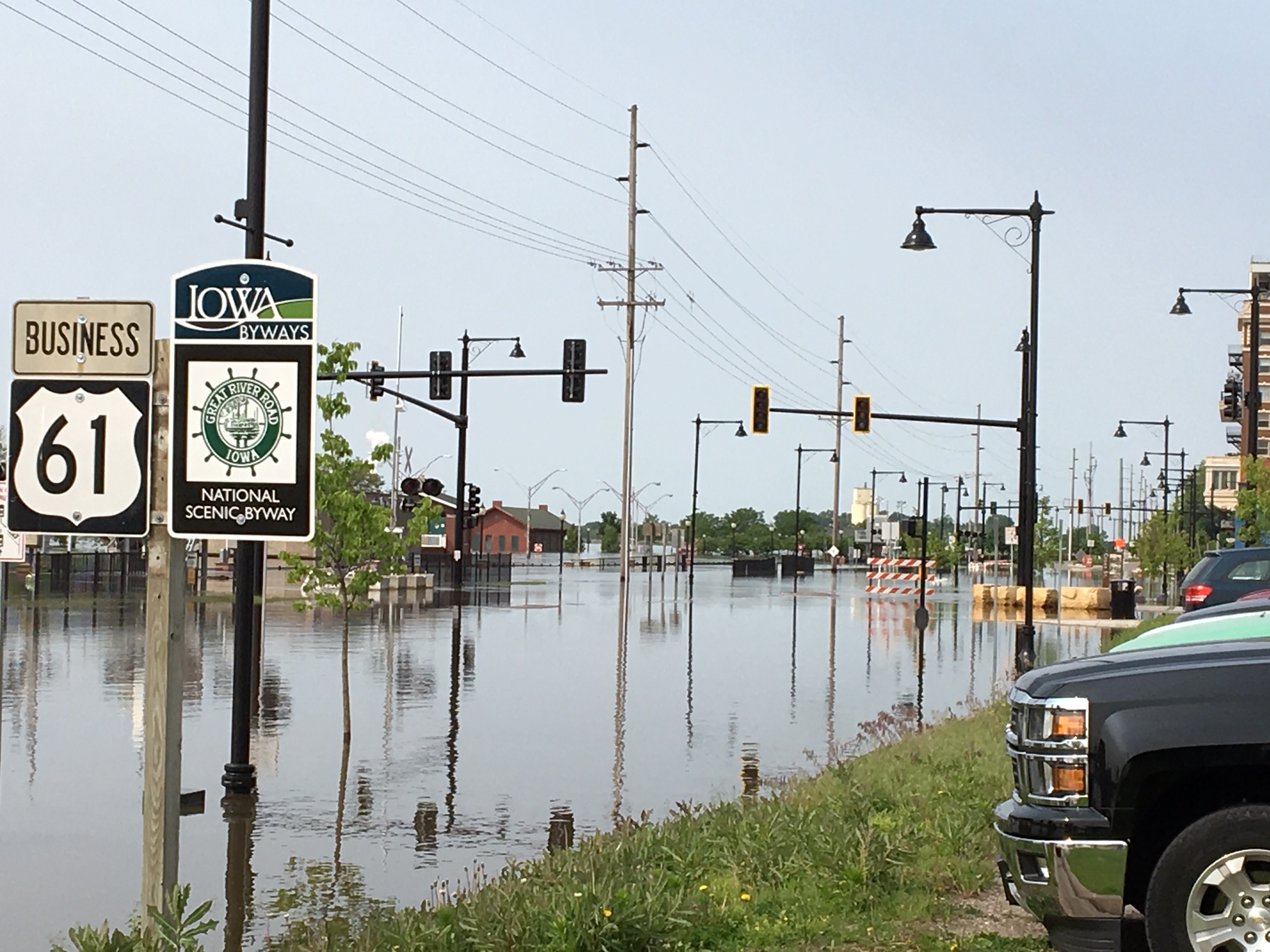 Mississippi River Flooding Muscatine, IA June 3rd, 2019 NWS Flood Survey |
Flooding
The Mississippi River has been in flood for most sites since the middle of March. It is the longest stretch the river has ever been above flood stage. Details of this statistic and others will be added to this page at a later date.
Jump to River: Mississippi Cedar Iowa English Skunk Des Moines Rock Green La Moine
Wapsipinicon River
 |
|||
| De Witt |
 |
 |
 |
|
| Cedar Rapids | Cedar Bluff | Conesville | |
 |
 |
 |
 |
| Marengo | Lone Tree | Wapello | Oakville |
 |
|||
| Kalona |
 |
 |
||
| Sigourney | Augusta Crest #1 |
 |
 |
||
| Keosauqua | St. Francisville |
 |
 |
 |
|
| Como | Joslin | Moline | |
 |
|||
| Geneseo |
 |
|||
| Colmar |
 |
 |
 |
 |
| Dubuque LD 11 | Dubuque Railroad Bridge | Bellevue LD 12 | Fulton LD 13 |
 |
 |
 |
 |
| Camanche | Le Claire LD 14 | Rock Island LD 15 | Illinois City LD 16 |
 |
 |
 |
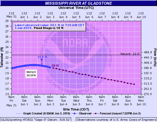 |
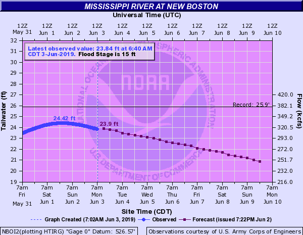
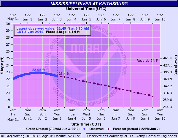
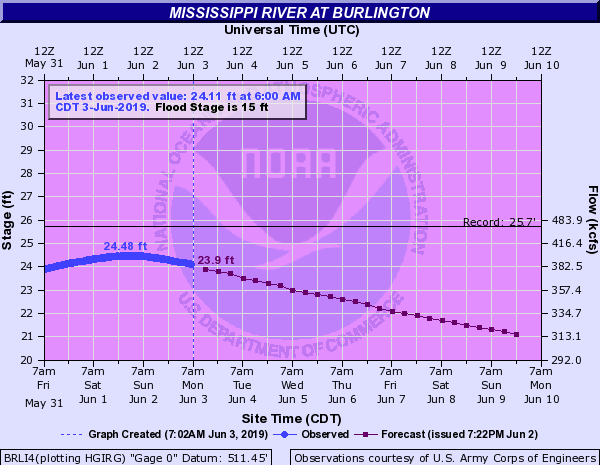
| Muscatine | New Boston LD 17 | Keithsburg | Gladstone LD 18 |
 |
 |
 |
|
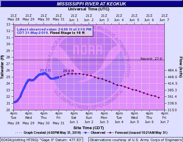
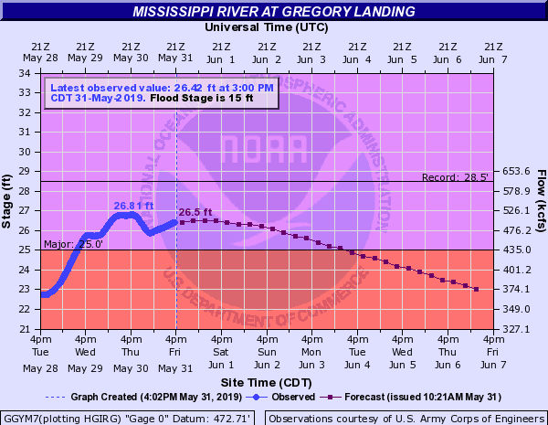
| Burlington | Keokuk LD 19 | Gregory Landing |
Factors that led to more flooding:
 |
 |
 |
|
| May 22nd - May 31st Rainfall | 48-hr Rainfall ending May 29th | May 13th - June 12th Precipitation | |
 |
 |
 |
|
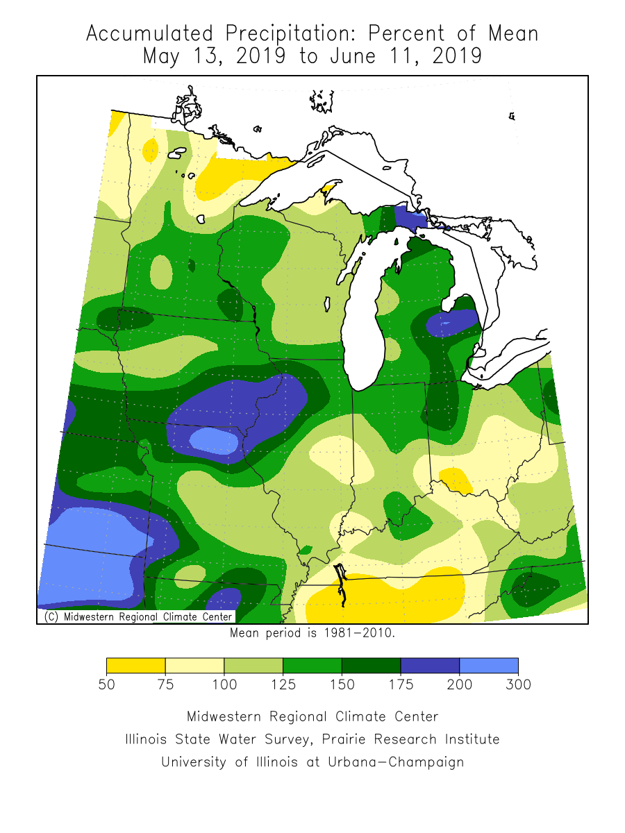
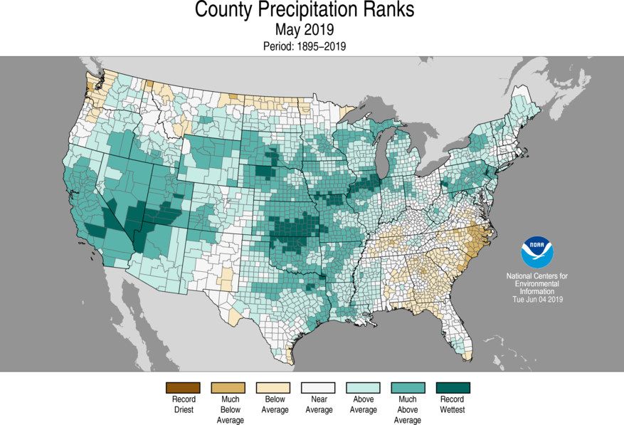
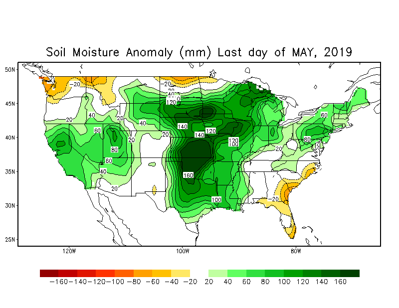
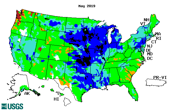
| May 13th - June 11th, 2019 Accumulated Precipitation Percent of Mean | County Precipitation Ranks for May 2019 | Soil Moisture Anomaly May 31st, 2019 | |
 |
|||
| Average Streamflow for May 2019 | |||
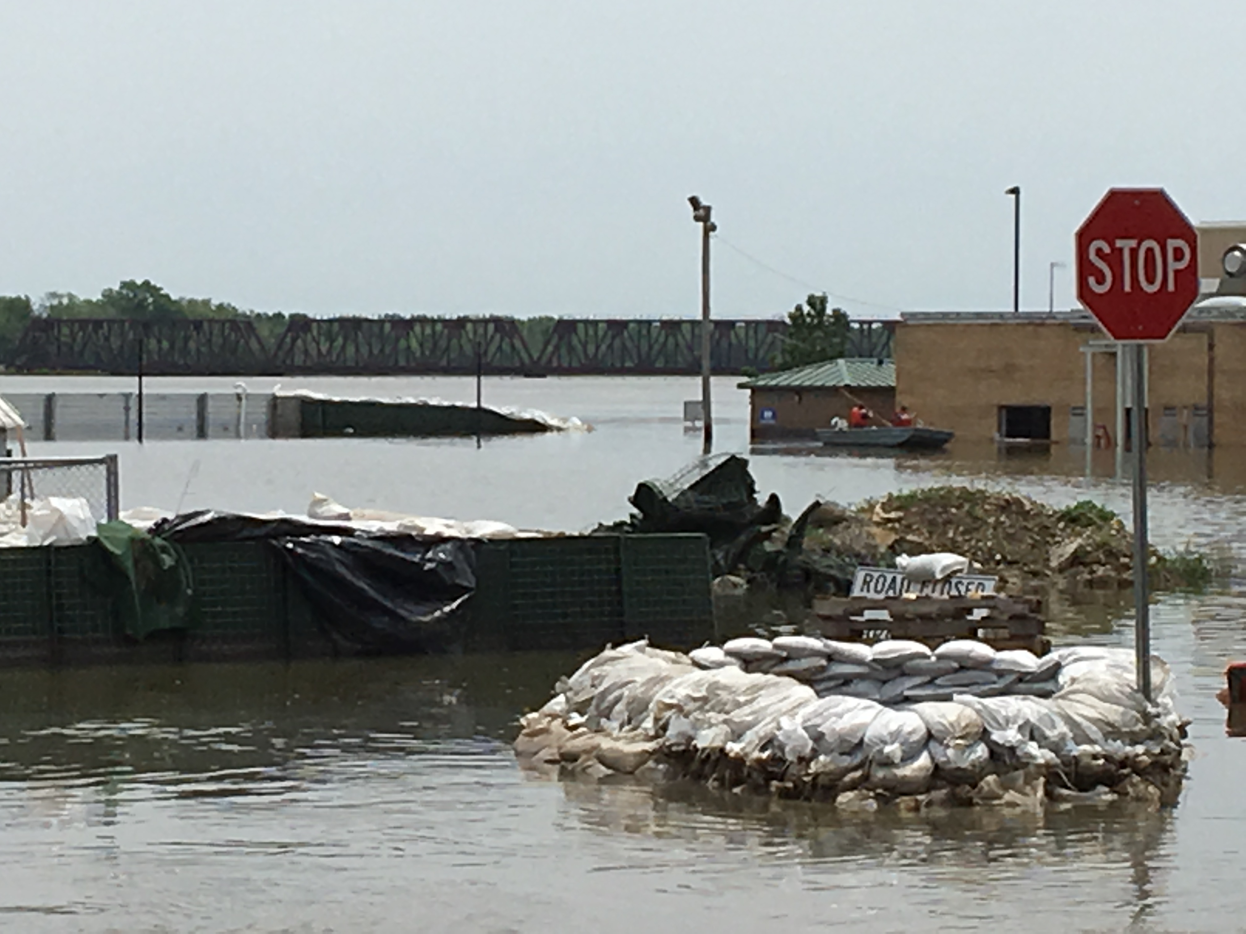
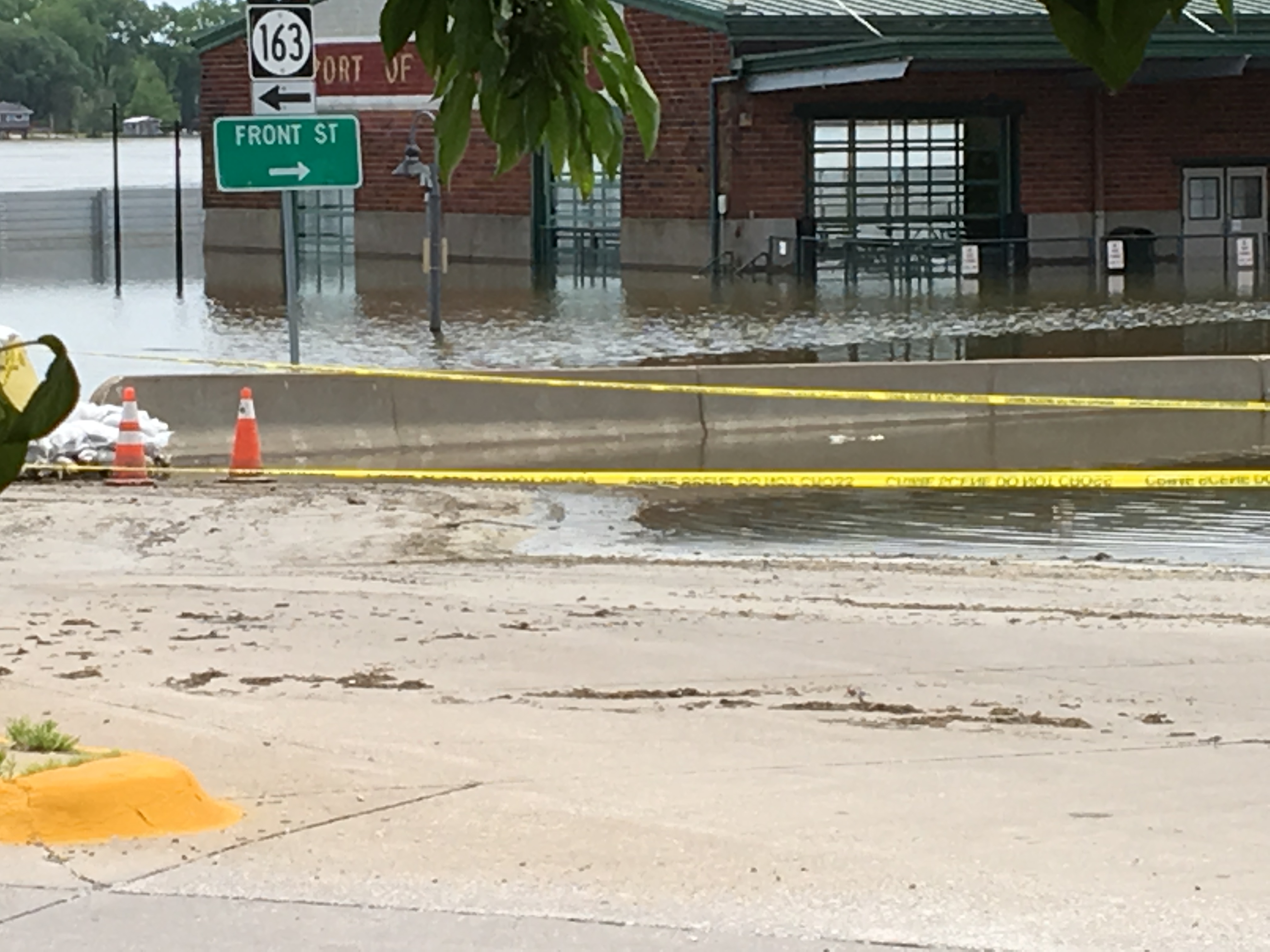
Photos
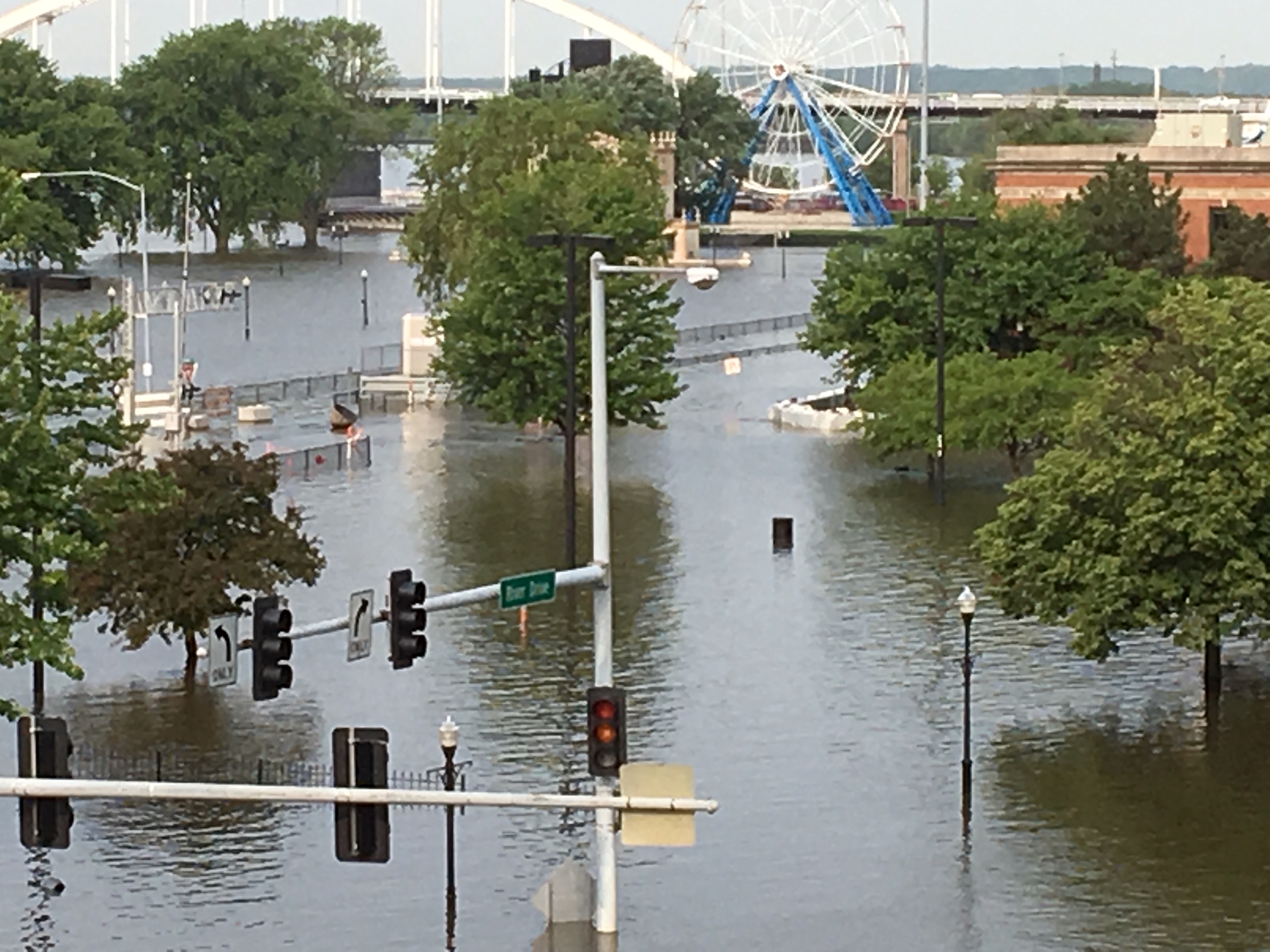
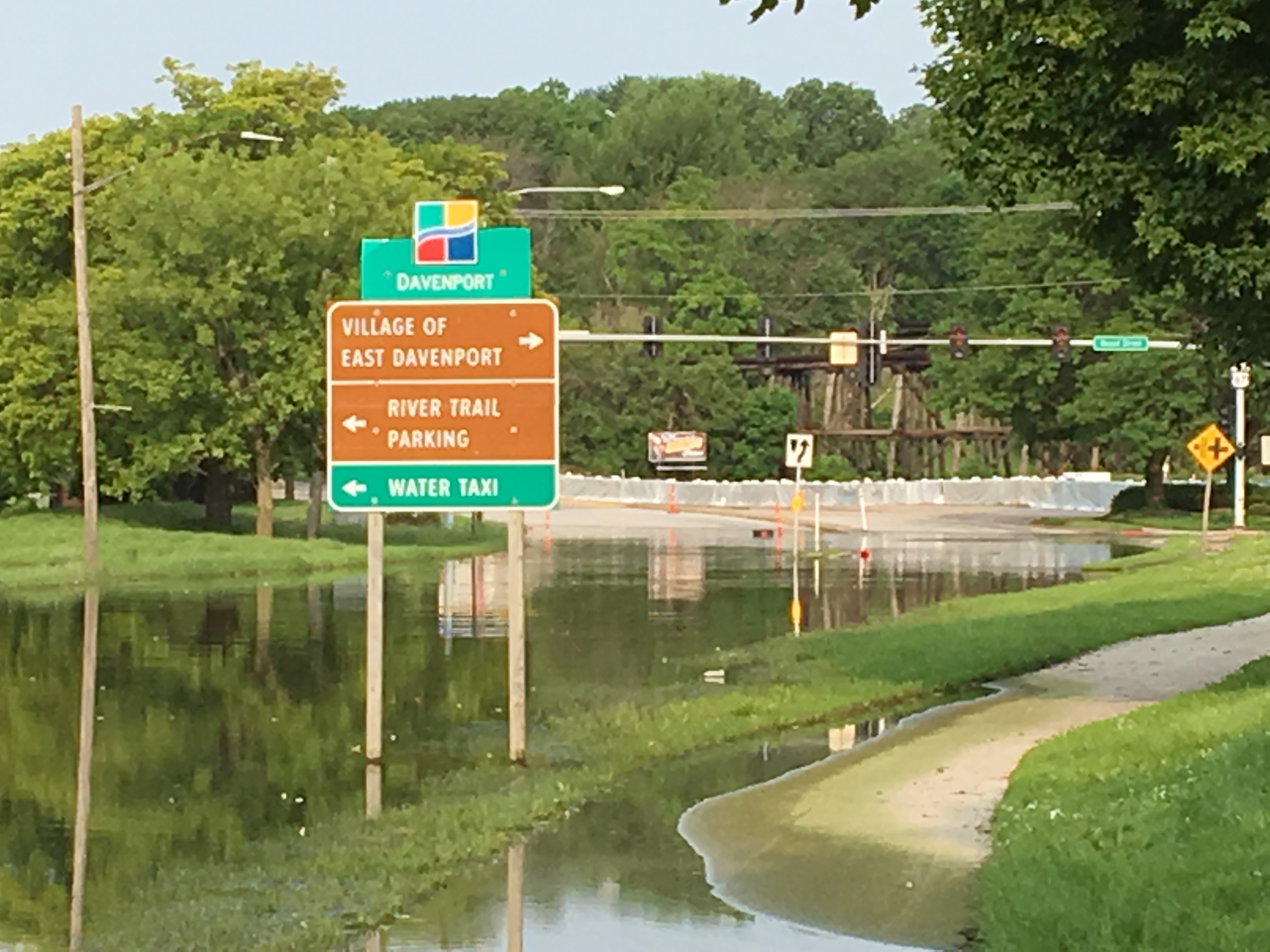
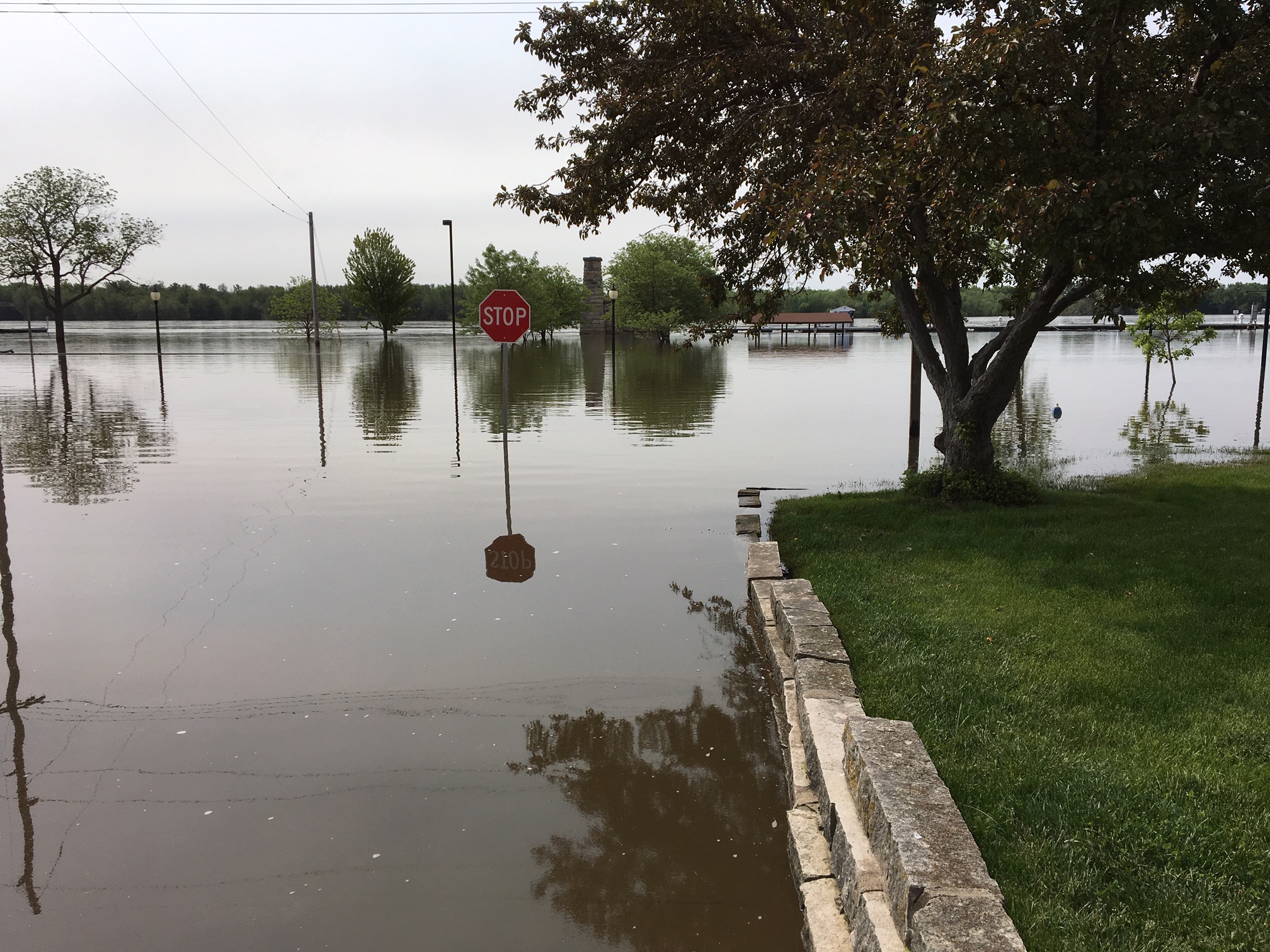
Mississippi River
 |
 |
 |
 |
| Davenport, IA (NWS Survey) |
East Davenport, IA (NWS Survey) |
Muscatine, IA (NWS Survey) |
Buffalo, IA (NWS Survey) |
 |
 |
 |
|
| Port Louisa , IA (NWS Survey) |
Burlington, IA (NWS Survey) |
Burlington, IA (NWS Survey) |
Crest Information
| Summary of Area Rivers | ||||
| River | Location | Flood Stage | Record Stage | Actual Crest (Preliminary) |
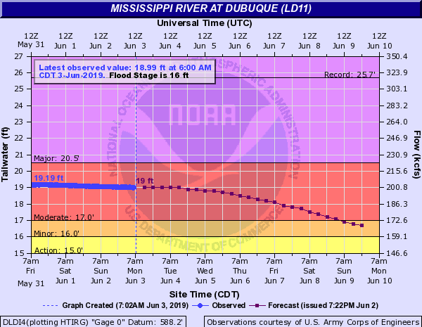
| Mississippi River | Dubuque LD 11 (DLDI4) | 16.0 ft | 25.69 ft on 04/26/1965 | 19.19 ft. on 05/31/2019 |
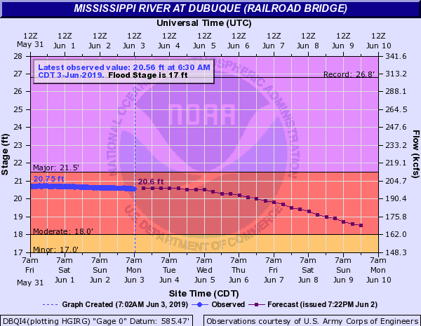
| Dubuque (DBQI4) | 17.0 ft | 26.81 ft on 04/26/1965 | 20.75 ft. on 05/31/2019 | |
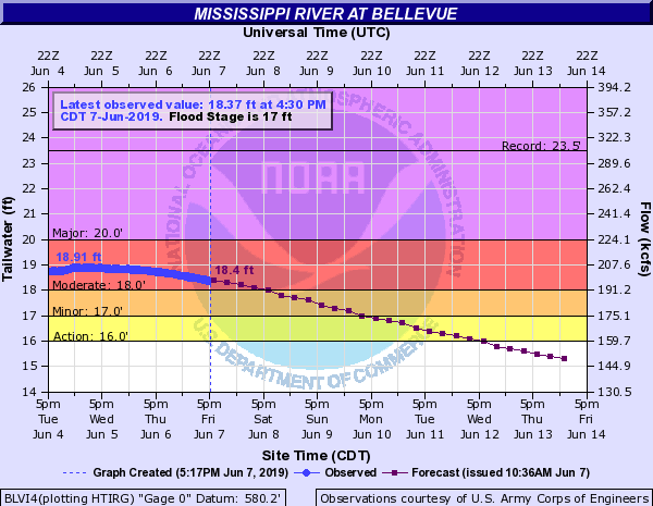
| Bellevue LD12 (BLVI4) | 17.0 ft | 23.51 ft on 04/26/1965 | 18.81 ft. on 05/31/2019 | |
| 18.91 ft. on 06/05/2019 | ||||
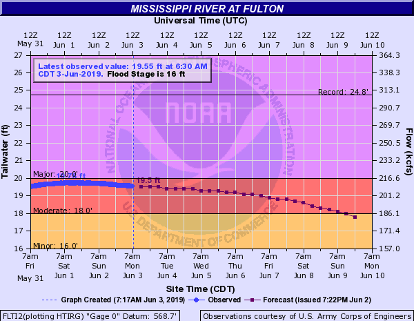
| Fulton LD 13 (FLTI2) | 16.0 ft | 24.75 ft on 04/28/1965 | 19.76 ft. on 06/01/2019 | |
| 19.83 ft. on 06/05/2019 | ||||
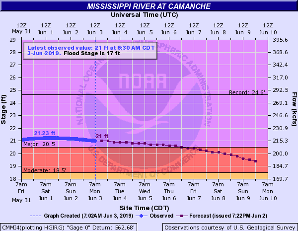
| Camanche (CMMI4) | 17.0 ft | 24.65 ft on 04/28/1965 | 21.23 ft. on 06/01/2019 | |
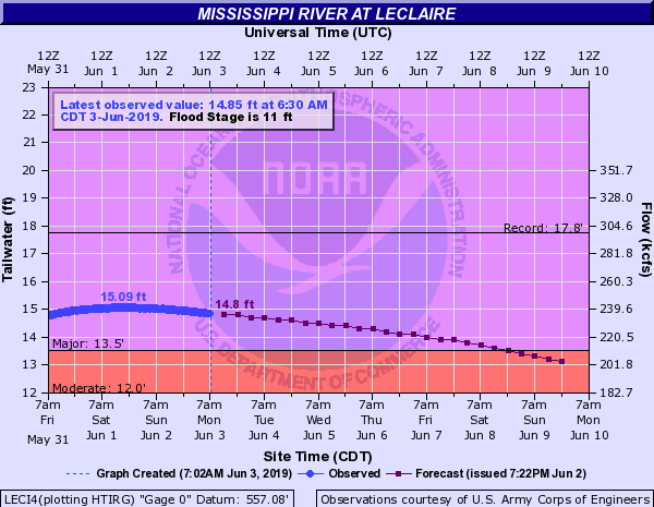
| Le Claire LD 14 (LECI4) | 11.0 ft | 17.75 ft on 04/28/1965 | 15.08 ft. on 06/01/2019 (6th highest crest on record) |
|
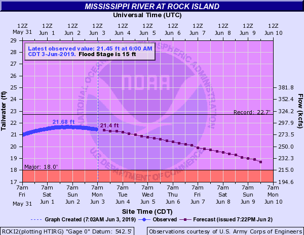
| Rock Island LD 15 (RCKI2) | 15.0 ft | 22.70 ft on 05/02/2019 | 21.68 ft. on 06/01/2019 (6th highest crest on record) |
|
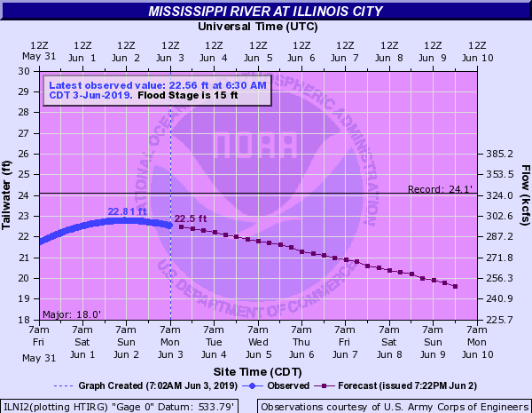
| Illinois City LD 16 (ILNI2) | 15.0 ft | 24.10 ft on 07/09/1993 | 22.81 ft. on 06/02/2019 (5th highest crest on record) |
|
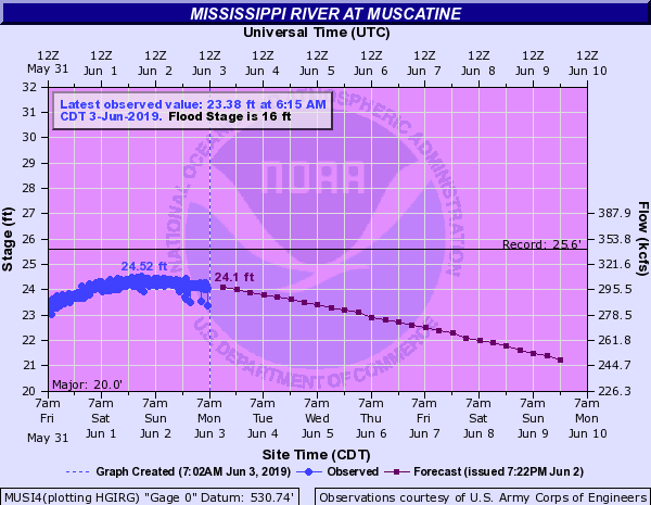
| Muscatine (MUSI4) | 16.0 ft | 25.61 ft on 07/09/1993 | 24.52 ft. on 06/02/2019 (3rd highest crest on record) |
|
| New Boston LD 17 (NBOI2) | 15.0 ft | 25.90 ft on 07/09/1993 | 24.42 ft. on 06/02/2019 (4th highest crest on record) |
|
| Keithsburg (KHBI2) | 14.0 ft | 24.49 ft on 06/17/2008 | 22.95 ft. on 06/02/2019 (3rd highest crest on record) |
|
| Gladstone LD 18 (GLDI2) | 10.0 ft | 22.46 ft on 06/17/2008 | 20.62 ft. on 06/02/2019 (3rd highest crest on record) |
|
| Burlington (BRLI4) | 15.0 ft | 25.73 ft on 06/17/2008 | 24.48 ft. on 06/02/2019 (3rd highest crest on record) |
|
| Keokuk LD 19 (EOKI4) | 16.0 ft | 27.58 ft on 07/10/1993 | 25.60 ft. on 05/30/2019 (3rd highest crest on record) |
|
| Gregory Landing (GGYM7) | 15.0 ft | 28.49 ft on 07/09/1993 | 29.97 ft. on 06/02/2019 (3rd highest crest on record) |
|
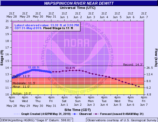
| Wapsipinicon River | De Witt (DEWI4) | 11.0 ft | 14.32 ft on 07/02/2014 | 13.68 ft on 05/30/2019 (7th highest on record) |
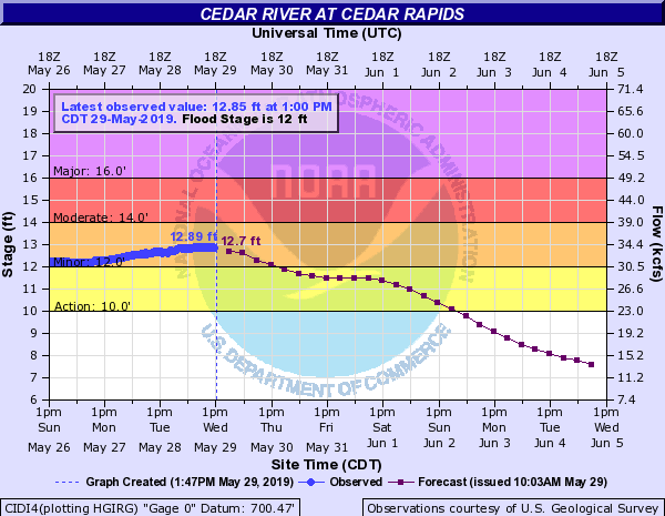
| Cedar River | Cedar Rapids (CIDI4) | 12.0 ft | 31.12 ft on 06/13/2008 | 12.90 ft. on 05/29/2019 |
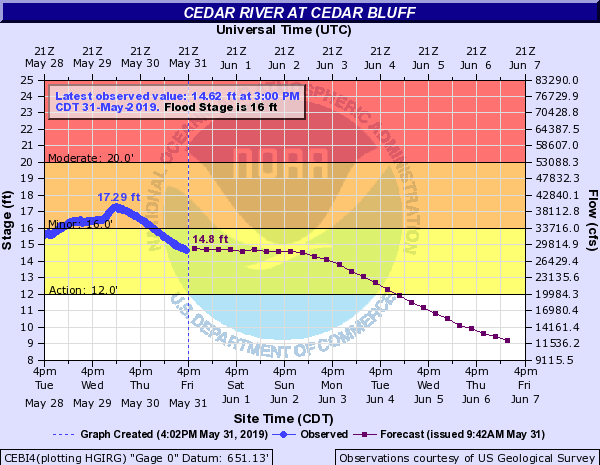
| Cedar Bluff (CEBI4) | 16.0 ft | 24.70 ft on 09/28/2016 | 17.30 ft on 05/30/2019 | |
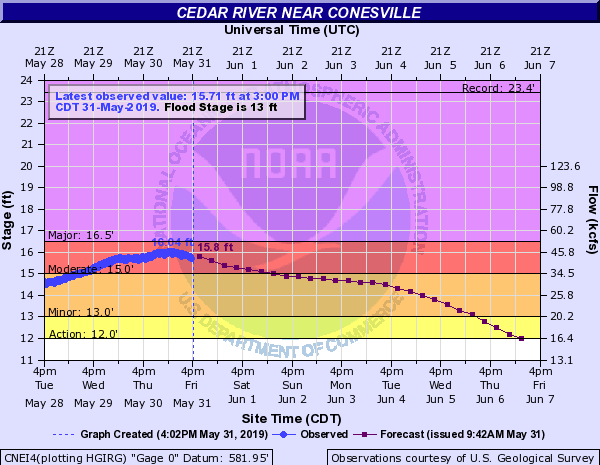
| Conesville (CNEI4) | 13.0 ft | 23.40 ft on 06/15/2008 | 16.04 ft. on 05/31/2019 | |
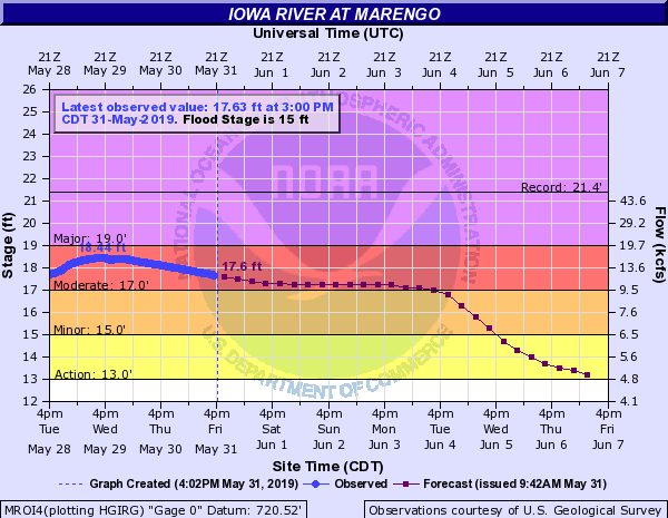
| Iowa River | Marengo (MROI4) | 15.0 ft | 21.38 ft on 06/12/2008 | 18.42 ft. on 05/29/2019 |
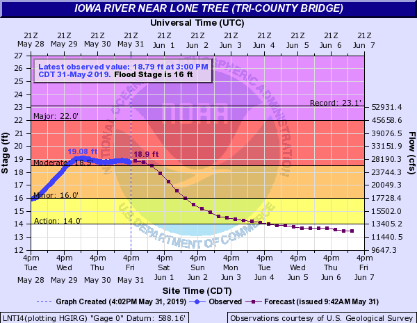
| Lone Tree (LNTI4) | 16.0 ft | 23.10 ft on 06/15/2008 | 19.08 ft. on 05/30/2019 (9th highest crest on record) |
|
| Columbus Jct (CJTI4) | 23.0 ft | 32.30 ft on 06/14/2008 | 24.95 ft on 05/31/2019 (6th highest crest on record) |
|
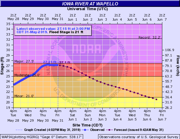
| Wapello (WAPI4) | 21.0 ft | 32.15 ft on 06/14/2008 | 27.21 ft on 05/31/2019 (9th highest on record) |
|
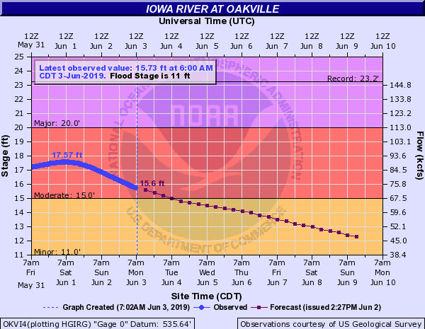
| Oakville (OKVI4) | 11.0 ft | 23.22 ft on 06/14/2008 | 17.56 ft on 06/01/2019 (3rd highest on record) |
|
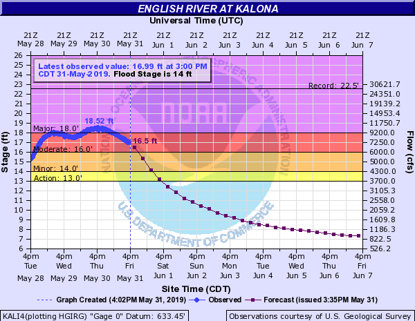
| English River | Kalona (KALI4) | 14.0 ft | 22.55 ft on 07/06/1993 | 18.71 ft on 05/30/2019 |
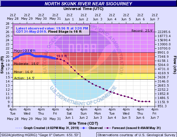
| Skunk River | Sigourney (SIGI4) | 16.0 ft | 25.93 ft on 05/28/2013 | 22.76 ft. on 05/19/2019 |
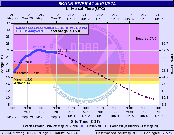
| Augusta (AGSI4) | 15.0 ft | 27.05 ft on 04/23/1973 | 24.05 ft on 05/30/2019 (5th highest on record) |
|
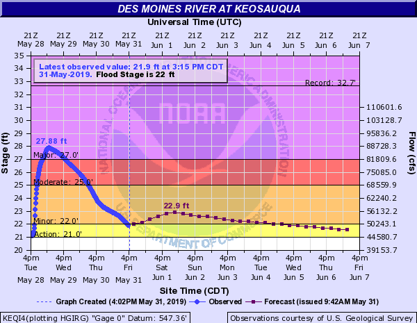
| Des Moines River | Keosauqua (KEQI4) | 22.0 ft | 32.66 ft on 07/13/1993 | 27.87 ft on 05/29/2019 (5th highest on record) |
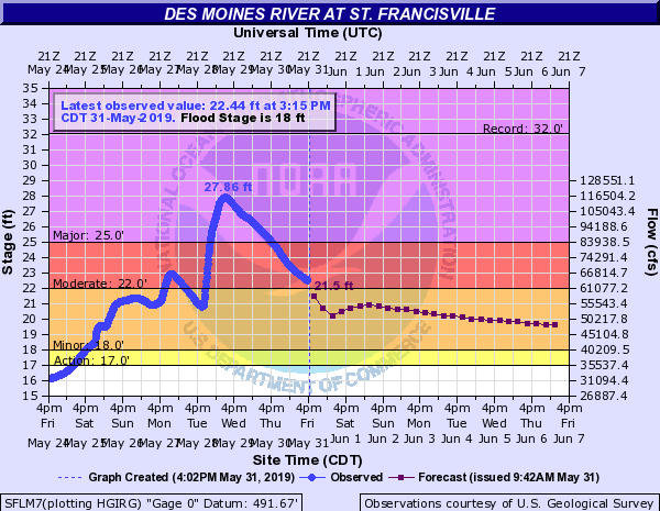
| St. Francisville (SFLM7) | 18.0 ft | 32.02 ft on 07/15/1993 | 27.86 ft on 05/29/2019 (5th highest on record) |
|
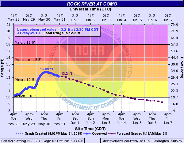
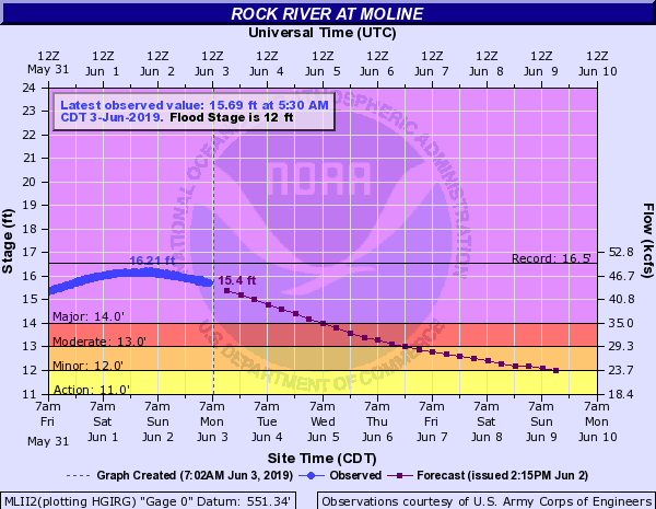
| Rock River | Como (CMOI2) | 12.5 ft | 15.65 ft on 07/23/2017 | 13.89 ft. on 05/30/2019 |
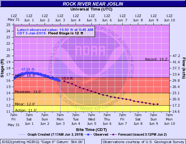
| Joslin (JOSI2) | 12.0 ft | 19.24 ft on 06/07/2002 | 17.32 ft. on 06/01/2019 | |
| Moline (MLII2) | 12.0 ft | 16.53 ft on 04/21/2013 | 16.21 ft. on 06/02/2019 (3rd highest crest on record) |
|
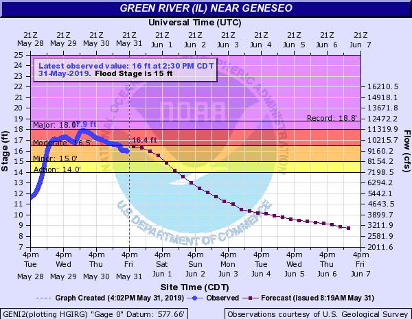
| Green River | Geneseo (GENI2) | 15.0 ft | 18.77 ft on 10/18/1998 | 17.90 ft. on 05/30/2019 (8th highest crest on record) |
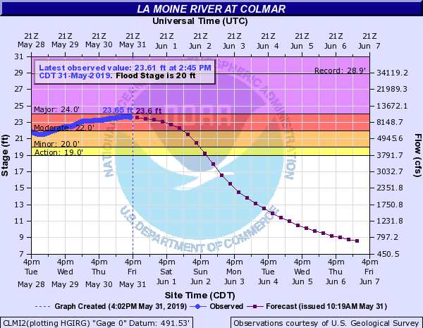
| La Moines River | Colmar (CLMI2) | 20.0 ft | 28.94 ft on 04/19/2013 | 24.06 ft. on 05/26/2019 |
River and streamflow information:
Flood safety and flood insurance information:
Precipitation, temperature, and soil moisture information:
 |
Media use of NWS Web News Stories is encouraged! Please acknowledge the NWS as the source of any news information accessed from this site. |
|

