There are no watches, warnings, or advisories at this time.
Today
Tonight
Possible Heavy Rain Saturday
Weather for the Week
August Outlook
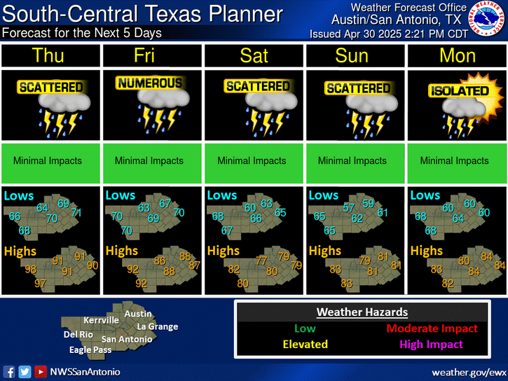
Scattered showers and thunderstorms are expected across most of south central Texas today. Locally heavy rainfall and gusty winds will be possible. Highs will be in the lower 90s to near 100 degrees.
A weak disturbance will bring a slight chance of showers and storms to mainly northern and central counties this evening. Tonight's lows will be in the 70s. Winds will be from the east and southeast at around 5 mph.
More rounds of afternoon and evening storms are forecast for Saturday. Locally heavy rainfall of 1 to 2 inches is the main concern, but there could be a few areas that see wind gusts in excess of 50 mph during the hottest time of the day. Frequent lightning will be possible in the stronger storms.
Seasonably hot temperatures will continue through the first week of August. Isolated to scattered showers and storms are expected Sunday and Monday over many areas with locally heavy downpours and gusty winds possible. Then, most areas remain dry with near normal temperatures through most of the upcoming week.


 Austin/San Antonio Radar
 Weather Map
 Satellite Imagery
 Del Rio Radar
 Digital Forecast Map
 Tropical Outlook
 Drought Status
 Air Quality
 Fire Weather Forecasts
 Observed Rainfall
 Observed Temperatures
 Daily Climate Graphs