HOME
FORECAST
Local
Graphical
Aviation
Marine
Rivers and Lakes
Hurricanes
Severe Weather
Fire Weather
Sun/Moon
Long Range Forecasts
Climate Prediction
Space Weather
PAST WEATHER
Past Weather
Heating/Cooling Days
Monthly Temperatures
Records
Astronomical Data
SAFETY
Tsunamis
Floods
Beach Hazards
Wildfire
Cold
Tornadoes
Air Quality
Fog
Heat
Hurricanes
Lightning
Safe Boating
Rip Currents
Thunderstorms
Space Weather
Sun (Ultraviolet Radiation)
Safety Campaigns
Wind
Drought
Winter Weather
INFORMATION
Wireless Emergency Alerts
Brochures
Weather-Ready Nation
Cooperative Observers
Daily Briefing
Damage/Fatality/Injury Statistics
Forecast Models
GIS Data Portal
NOAA Weather Radio
Publications
SKYWARN Storm Spotters
StormReady
TsunamiReady
Service Change Notices
EDUCATION
Be A Force of Nature
NWS Education Home
NEWS
NWS News
Events
Pubs/Brochures/Booklets
NWS Media Contacts
SEARCH
Search For
NWS
All NOAA
ABOUT
About NWS
Organization
Strategic Plan
Commitment to Diversity
For NWS Employees
International
National Centers
Careers
Contact Us
Glossary
Social Media
Local forecast by
"City, St" or ZIP code
Sorry, the location you searched for was not found. Please try another search.
Multiple locations were found. Please select one of the following:
Location Help
News Headlines
Autumn 2023 Climate Summary
Winter Weather Preparedness Week 2023
Previous Headlines and Features appearing on our Front Page
Customize Your
Weather.gov
Enter Your City, ST or ZIP Code
Remember Me
LOADING...
Peachtree City, GA
Weather Forecast Office
Latest Weather Observations Across Georgia
Weather.gov
>
Peachtree City, GA
> Latest Weather Observations Across Georgia
Current Hazards
Outlooks
Submit a Storm Report
Local Warnings
Nationwide
Outlooks
Local Storm Reports
Georgia Road Conditions
Current Conditions
Surface Observations
Satellite
Observed Precipitation
Satellite Images
Rivers/Lakes
Maps
Radar
Local KFFC Standard Radar (low bandwith)
Local KFFC Enhanced Radar
Local KJGX Standard Radar (low bandwith)
Local KJGX Enhanced Radar
Regional Standard Radar (low bandwith)
Forecasts
Hourly View
Activity Planner
Fire
Forecaster's Discussion
Local
Graphical
Tropical Weather
Aviation Weather
Winter Weather
Computer Models
Decision Support
Recreational Forecast
Rivers and Lakes
Climate and Past Weather
Climate Prediction
Drought
National
Rainfall
Yearly Climate Graphs
Climate FAQs
More...
Tropical Cyclone Reports
Local Programs
NOAA Weather Radio
SKYWARN®
StormReady
User's Guide
Education & Outreach
Archived Info
Past Weather Events
Research
FAQs
Our Office
Contact Us
Get additional weather conditions:
CURRENT
|||
PREVIOUS
" - " means data temporarily missing.
" * " use with caution. Not NWS data.
NOTE: Above data normally updated around 10 minutes after the hour.
Georgia Automated Environmental Monitoring Network
courtesy
The University of Georgia
Alapaha
Albany
Alma
Alpharetta
Alto
Arabi
Arlington
Atlanta
Attapulgus
Baxley
Blairsville
Blue Ridge
Brunswick
Butler
Byromville
Byron
Cairo
Calhoun
Camilla
Clarks Hill-SC
Cordele
Covington
Dahlonega
Dallas
Danielsville
Dawson
Dawson-HHERC
Dearing
Dixie
-
Donalsonville
Douglas
Dublin
Duluth
Dunwoody
Eatonton
Elberton
Ellijay
Fort Valley
Gainesville
Georgetown
Griffin
Griffin-Dempsey
Hatley
Homerville
Jeffersonville
Johns Creek
Jonesboro
LaFayette
McRae
Midville
Moultrie
Nahunta
Newman
Newton
-
Oakwood
Odum
Ossabaw
Penfield
Pine Mountain
Plains
Rome
Roopville
San Luis-CR
Sasser
Savannah
Shellman
Skidaway
Sparta
Statesboro
Steam Mill
Tennille
Tifton
Tifton-Bowen
Tiger
TyTy
Unadilla
Valdosta
Vidalia
Vienna
Watkinsville-Horticulture
Watkinsville-UGA
Watkinsville-USDA
Williamson
Woodbine
Live Webcams
Around Georgia
Athens, UGA
Brasstown Bald USFS
Columbus (WTVM)
Dahlonega
Savannah (WTOC SkyCam)
Savannah (WTOC Tower Cam)
Tallulah Falls
-
Atlanta Area
GA 316 @ Boggs Rd.
I-75 @ Delk
I-75 @ I-285 S
I-75 @ I-675
I-75 NB @ Wade Green
Roswell
Roswell, Queen of Angels School
Tara @ Flint River
WSB Tower Cam
MORE WEATHER !
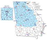
UGA Network, Private Stations, U.S. Forestry, & Live Web Cams
Go To Map w / Links >>>
MAPS
Conditions N & C Ga
Latest Heat Index
U.S. Forest Service
Remote Automated Weather Stations
Armuchee (Walker Co)
Brasstown (Towns Co)
Camp Merrill (Lumpkin Co)
Chattooga (Habersham Co)
Cohutta (Murray Co)
Oconee (Jasper Co)
Tallulah (Rabun Co)
Toccoa (Union Co)
Georgia Forestry Commission
Remote Automated Weather Stations
Adel (Cook Co)
Baxley (Appling Co)
Brender NF (Jones Co)
Byromville (Dooly Co)
Camilla (Mitchell Co)
Chatsworth (Murray Co)
Dallas (Paulding Co)
Dawsonville (Dawson Co)
Jones Island (Charlton Co)
Louisville (Jefferson Co)
McRae (Wheeler Co)
Metter (Candler Co)
Midway (Liberty Co)
Milledgeville (Baldwin Co)
Newnan (Coweta Co)
Plains (Sumter Co)
Stafford (Camden Co)
Sterling (Glynn Co)
Washington (Wilkes Co)
Watkinsville (Clarke Co)
Waycross (Ware Co)
Miscellaneous
Remote Automated Weather Stations
Fort Benning (Chattahoochee Co)
Private Wx Stations
Berkeley Lake
Big Canoe / Wet Mtn
Dacula
Dahlonega
Dahlonega 3NE
Dunwoody
Henry County
Henry County (north)
Woolsey
Roswell
Tallulah Falls
Follow us on Twitter
Follow us on Facebook
Follow us on YouTube
FFC RSS Feed