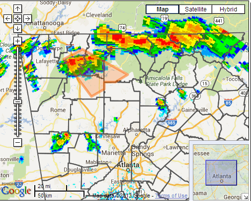
A late season cold front combined with warm temperatures ahead of the front and a potent upper level disturbance to result in over 60 reports of severe weather in north and central Georgia with this tally rising daily. The setup in the surface analysis image below shows the frontal boundary at 2pm on the 13th moving into the Tennessee valley with temperatures south of the front in the lower 90s allowing surface instability to be maximized. 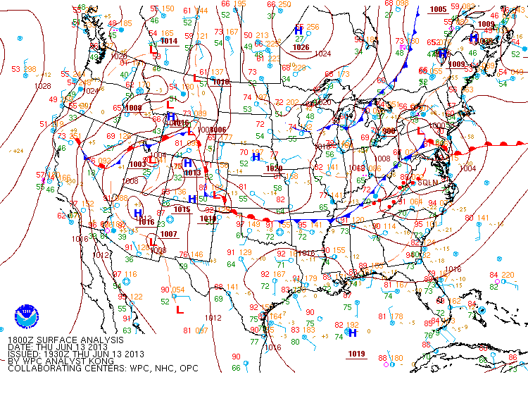 Map of MSL pressure, temperature and dew point temperature valid at 2 pm EDT, June 13, 2013. With the instability in place, an approaching broken line of storms to the north solidified with time, increasing in both intensity and coverage through the late afternoon hours. The radar image below shows the line as it entered north Georgia, already producing wind damage for the first tier of counties.
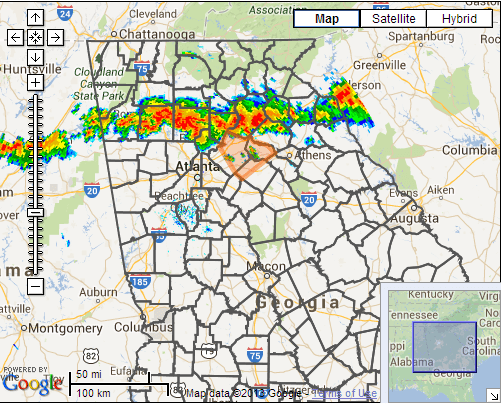
Radar imagery valid at 543 pm EDT, June 13, 2013. As discussed, the line filled in as it progressed south toward the Atlanta metro with the following image showing thunderstorms which were at the time producing widespread damaging winds as well as isolated large hail reports.
Radar imagery valid at 723 pm EDT, June 13, 2013.
It was around this time that the Peachtree City radar and especially the terminal Doppler radar at Atlanta indicated a circulation within the line over Cherokee County. This prompted what is somewhat of a rarity for June in Georgia which is the issuance of a tornado warning.
Radar imagery valid at 727 pm EDT, June 13, 2013. This circulation would produce the first of two tornadoes for the evening, this one over Cherokee county in which details are listed below. Cherokee County Tornado Rating: EF-1 Max wind speed: 105 MPH Path length: 8.5 miles Path width: 75 yards Injuries: 9 Deaths: 0 Start time: 7:00 PM EDT (June 13, 2013) End time: 7:25 PM EDT (June 13, 2013) Begin location: 4 miles WNW Canton End location: 5 miles SSE Canton Survey Summary: The tornado touched down near the intersection of Patriot Trail and Rampley Trail, then headed south towards Canton causing generally tree damage. Hundreds of trees were snapped or uprooted. In Canton, along Marietta Road and Hickory Flat Highway, a Chevron gas station had a portion of its roof peeled back and a gas pump blown over. Along Hickory Flat Highway dozens of trees were snapped or uprooted. The tornado curved to the right, heading south-southeast with additional tree damage along its approximately 8.5 mile path. The tornado lifted near the intersection of New Light Road and Hickory Road.
The same line of storms spawned a second tornado that tracked across Cherokee, Cobb, and Fulton Counties. Cherokee, Cobb and Fulton County Tornado Rating: EF-1 Max wind speed: 110 MPH Path length: 12.95 miles Path width: 200 yards Injuries: 0 Deaths: 0 Start time: 7:30 PM EDT (June 13, 2013) End time: 7:43 PM EDT (June 13, 2013) Begin location: 2 miles S of Woodstock Survey Summary: The tornado touched down within a tenth of a mile of the Cherokee-Cobb County line inside Cherokee County along Woodhaven Drive, bringing down trees and large limbs. The portion of damage within Cherokee County was rated an EF-0. The tornado then tracked southeast through Cobb County, with some of the most significant damage along Wendwood Drive NE and near Bishop Lake where dozens of trees were snapped and uprooted, many causing damage to homes. Within Cobb County the tornado strengthened to an EF-1. The tornado continued to track to the southeast, moving over the Chattahoochee River near Morgan Falls. It retained its EF1 strength as it snapped and uprooted doznes of trees along riverwalk, and damaged roofs at the Laurel at Overlook Park apartments. Netting polls at the driving range at the Steel Canyon Golf Club were damaged, with the netting ripped off or tangled. The tornado continued southeast, snapping or uprootingtrees until it finally lifted just short of the Dekalb county line, where it snapped and uprooted a few trees along Twin Branch road.
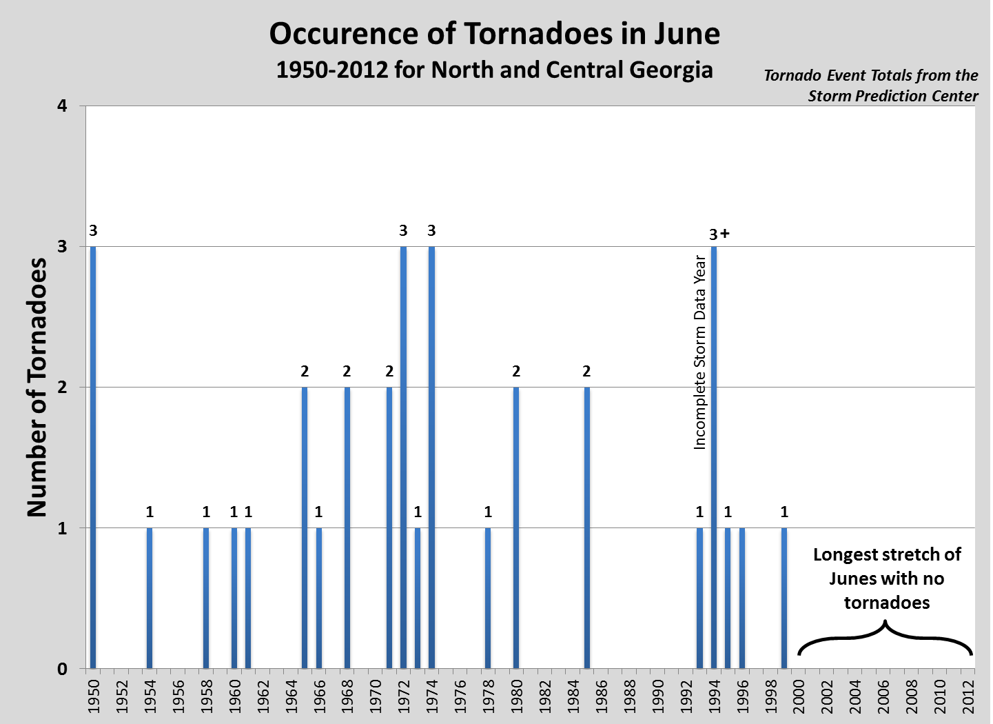
So just how rare are June tornadoes across north and central Georgia. The graph below shows that this has been the longest stretch of Junes since 1950 with no tornadoes. It is also the first June since 1994 with multiple confirmed tornadoes.
In addition to the tornadoes that impacted the area, widespread wind damage was experienced across north and central Georgia as evidenced by the local storm report map shown below. 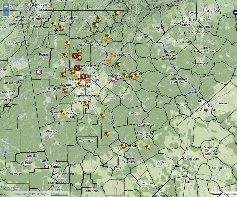 |