National Weather Service United States Department of Commerce

Severe Thunderstorms, Heavy Rainfall and Dangerous Heat

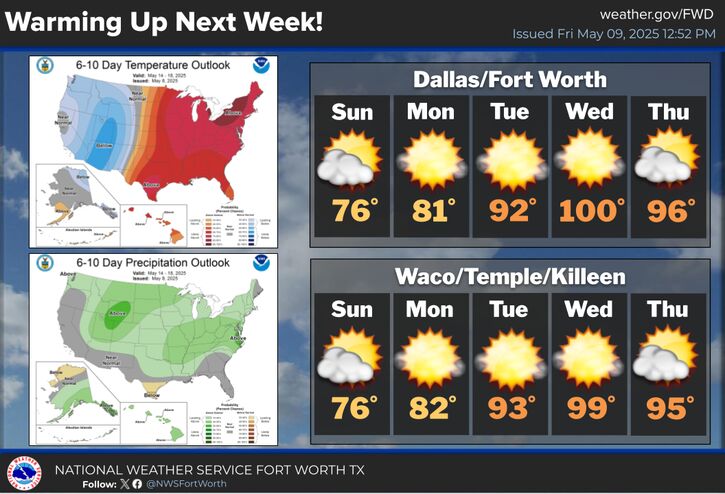
Severe thunderstorms are expected today and Friday from the upper Midwest, central Great Lakes into the Ohio and mid-Mississippi Valley's. In addition, heavy rainfall threat increases on Friday across the Ohio Valley. Meanwhile, early summer-like heat wave across portions of southern Texas with new daily records are forecast today and through the weekend; The heat spreads across the Gulf States. Read More >

Click a location below for detailed forecast.

Last Map Update: Fri, May 16, 2025 at 12:20:28 am CDT

Storm chances will increase Friday afternoon and evening, isolated strong to severe thunderstorms will be possible (30% chance) along and east of a dryline extending from southeast Oklahoma into the Texas Hill country. Capping will be weaker on Friday compared to Thursday, so there is more confidence that a few storms will develop in our area. Storms that develop should still remain isolated, and as a result, the majority of us should still remain dry. For any storm that develops, large hail and damaging winds will be the primary hazards.
Scattered severe thunderstorms will be possible on Saturday and Sunday across parts of North Texas as the dryline becomes more active. Thunderstorms will likely develop during the late afternoon hours on Saturday and become severe as they move east. Large hail and damaging winds will be possible with any storms that develop. Additional scattered severe storms will be possible on Sunday, although the threat may shift a little farther north and west.
Isolated showers and storms will remain possible for areas east of the I-35 corridor tonight, before coming to an end around midnight. Skies will remain cloudy overnight, with temperatures dropping into the mid 60s to mid 70s.
A period of active weather will continue into early next week with storm chances both Monday and Tuesday. Highs will be in the 80s and 90s.

Text Product Selector (Selected product opens in current window)
Latest Text Products Issued (Experimental)
Safe Rooms Icon Cooperatirve Rainfall (CoCoRaHs) icon Storm Ready Icon AirNow Icon