-

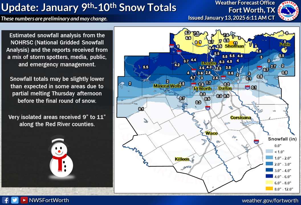
- January 9-10, 2025
-
Multiple rounds of measurable snow fell within a 24-hour period, mainly along and north of the I-20 corridor. Totals exceeded 6 inches along the Red River, including isolated amounts of 9 to 11 inches in Cooke and Grayson counties.
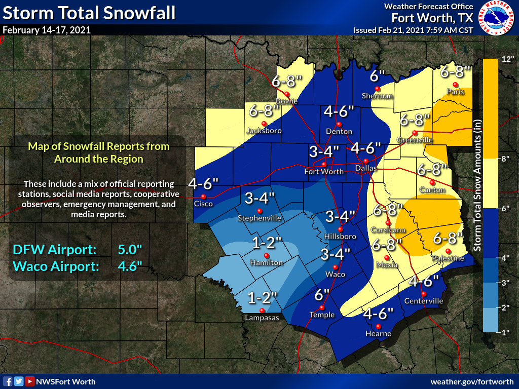
- February 14-17, 2021
-
During a severe arctic outbreak, multiple rounds of snowfall occurred. Event totals of 6 to 8 inches were widespread in areas east of the I-35 corridor as well as across portions of Northwest Texas. The 5-inch tally at DFW Airport was the highest event total in more than a decade, and Waco's 4.6 inches was the greatest amount in nearly 40 years.
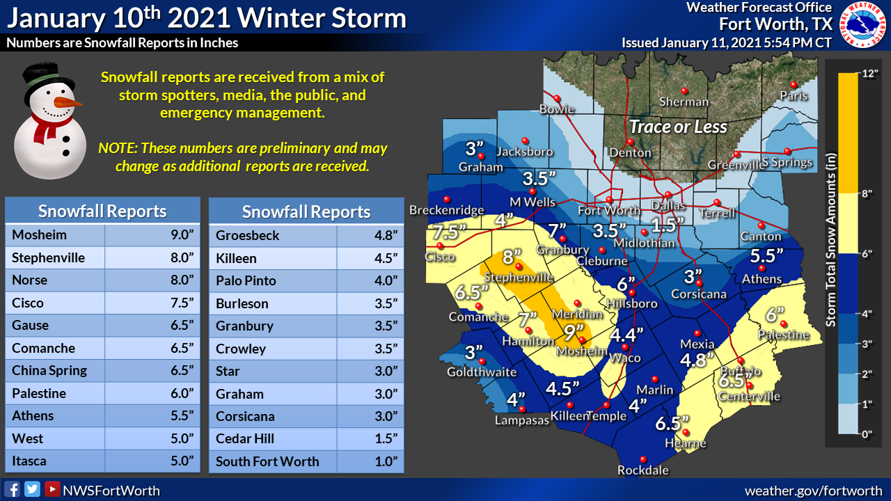
- January 10, 2021
-
Many locations across Central Texas tallied more than 6 inches of snow, making this event one of the most significant on record. Mosheim (Bosque County) reported 9 inches. Stephenville saw 8 inches, and Palestine tallied 6 inches.
- March 4-5, 2015
-
Widespread snow resulted in measurable amounts regionwide. From northern portions of the Dallas/Fort Worth Metroplex into Northeast Texas, event totals were 5 to 6 inches.
- February 27, 2015
-
Heavy snow fell from the Big Country into Texoma. The greatest event totals were from Breckenridge (6 inches) to Decatur (7 inches).
- December 5-6, 2013
-
Heavy sleet and freezing rain fell across much of the region, resulting in accumulations of as much as 4 to 5 inches in the Sherman/Denison area. Persistent cloud cover caused the icy conditions to refreeze over multiple days, during which the term "cobblestone ice" was coined. DFW Airport endured prolonged impacts to operations.
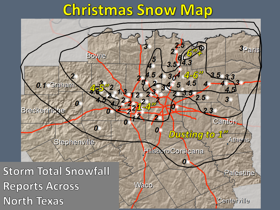
- December 25, 2012
-
On Christmas Day, a strong upper level system and cold front first brought hail-producing thunderstorms to the region, then a winter weather event that included snow and sleet. The storms produced lots of pea sized hail and occasionally slightly larger hail. The snow fell generally north of a line from Breckenridge to Palestine. The greatest concentration of heavy snow was in western Denton County and Collin County where 4 to 6 inches of snow fell. There were also isolated locations that received 4 to 6 inches of snow in Parker, Grayson, Fannin, Hunt, and Emory counties. The overall impacts from the sleet and snow were minimal but there were the usual impacts to transportation in the region when the snow froze on area roads that night; especially on elevated roadways, bridges, and overpasses.
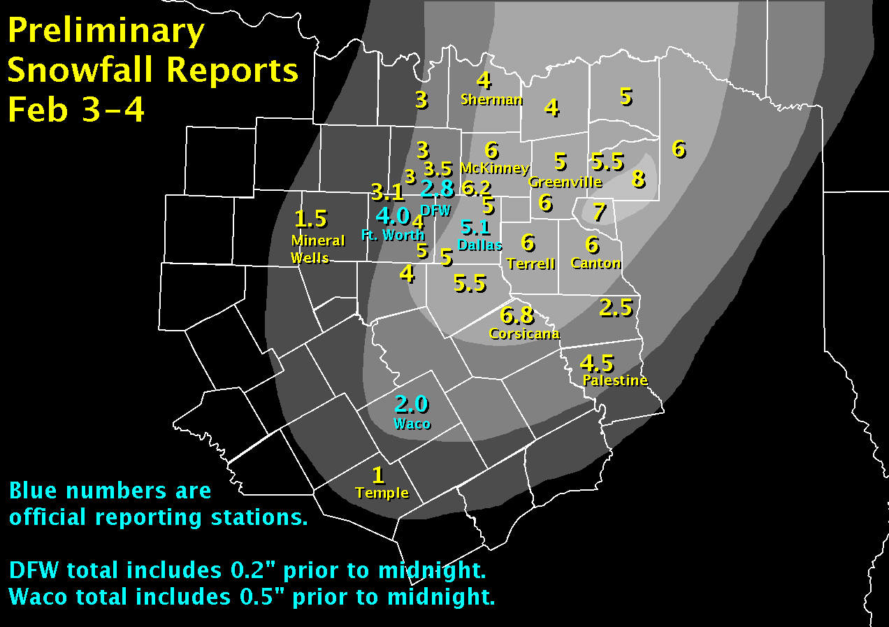
- February 3-4, 2011
-
Snow began in Central Texas during the evening hours of February 3. The snow spread north overnight, impacting nearly all of North Texas. Snow continued in Northeast Texas into the evening hours of February 4.
Dallas Love Field measured 5.1 inches for the event. Totals of 6 inches or more could be found in Collin County, and from Corsicana to Terrell and Canton. The heaviest amounts were 7 to 8 inches, from Emory and Sulphur Springs to Mineola and Mount Pleasant.
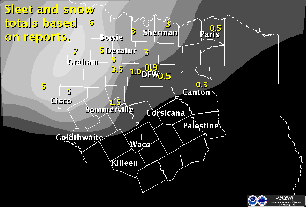
- February 1, 2011
- Heavy rain accompanied a strong arctic front. The precipitation transitioned to heavy sleet thunderstorms during the early morning hours of February 1. Winds gusted over 50 mph at DFW Airport with heavy sleet. The precipitation changed to snow before ending, accumulating 6 to 7 inches of frozen precipitation in Graham and Olney.
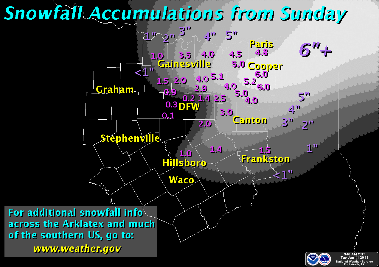
- January 9-10, 2011
- Heavy rain affected much of North Texas on January 9, transitioning to heavy snow in Northeast Texas. Some light snow continued during the early morning hours of January 10. As much as 6 inches of snow fell from Sulphur Springs to Cooper, where the snow remained on the ground for several days.
- March 20-21, 2010
-
An unusually strong and cold upper level low slowly moved along the Red River Valley on March 20 and 21. Heavy snowfall occurred on the backside of the low with measurable snowfall occurring mainly to the north of I-20.
A very localized and heavy band of snow developed during the early morning hours of the 21st, dumping 5 to 9 inches of snow across Collin County.
Some locations just 20 miles to the southwest of this band of snow only picked up 1 inch. Snow continued into the early afternoon hours on the 21st across East Texas before ending.
- February 23, 2010
-
A strong upper level low pressure system tracked across Central Texas and brought a significant snow event to the region. The highest accumulations of 3 to 5 inches occurred south of I-20 near where the center of the upper low tracked.
Snow began in the Hill Country during the early morning hours. Heavy snow spread across Central Texas and moved into East Texas during the afternoon hours before ending.
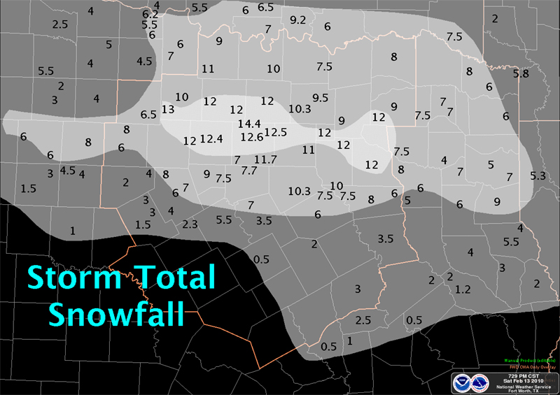
- February 11-12, 2010
-
Record breaking snow fell across North Central Texas. Cold air was already in place when a slow moving upper level low approached.
The low slowed significantly as it got closer to the region, and this allowed relatively warm and moist air to move over the colder air at the surface for an extended period of time.
This very unusual event brought snowfall totals of a foot or more for many locations around the DFW Metroplex. Haslet reported 14.4 inches, while DFW Airport had a record breaking 12.5 inches in 24 hours.
Widespread power outages resulted from the heavy snow, weighing down tree limbs and breaking transmission lines. Clean up from the tree damage lasted for weeks.
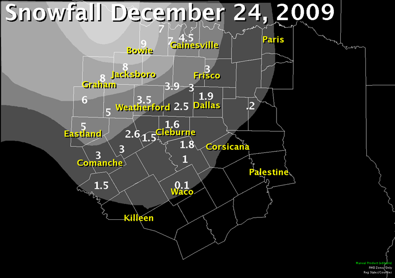
- December 24, 2009
-
A powerful upper level low brought near blizzard conditions to North Texas on Christmas Eve. Winds gusted to 40 to 50 mph while snow was falling resulting in very low visibilities and blowing snow.
Snow began to fall during the late morning hours, increasing in intensity during the afternoon. Snowfall amounts were heaviest northwest of the Metroplex where Graham and Bowie recorded 6 to 9 inches of snow.
From Comanche to the DFW Metroplex into the Sherman/Denison area, 2 to 3 inches of snow fell. This snow remained on the ground the next morning, giving many areas a white Christmas.
- March 6-7, 2008
-
Rain changed over to heavy snow and thundersnow during the late morning hours in areas northwest of the DFW Metroplex. Decatur and Gainesville reported 9 inches of snow with this event.
A stationary rain/snow line resulted in dramatically different snow totals across the Metroplex. Northern Tarrant County had up to 7 inches of snow, DFW recorded only 1.1 inches, and much of the Metroplex saw less than 1 inch.
More light snow developed across the eastern Metroplex and into Northeast Texas in the early morning hours of March 7, but amounts were less than 1 inch.
- March 3, 2008
- An upper level low produced snow for most areas along and north of I-20 where amounts generally ranged from a trace to 3 inches. A localized intense band of heavy snow centered over Grayson County produced as much as 6 inches of snow. DFW recorded 1 inch.
- April 7-8, 2007
- Snow fell in areas south of I-20 during the daytime hours of the Saturday before Easter. The highest amounts of 3 to5 inches were found in a band from Comanche and Goldthwaite to Waco and Temple/Killeen. Bluebonnets were already in bloom when this snow fell, making for unique pictures of this event.
- March 27, 2005
- An upper level low produced a very localized narrow band of 1-2 inches of snow from Graham to Weatherford to Benbrook to Cleburne in the predawn hours of Easter morning. Most areas outside the snow band saw only moderate to heavy rain.
- February 14, 2004
- Between 2-5 inches of snow were widespread over the northern half of North Texas. The event began during the early morning hours, and generally ended by midday over the Metroplex.
- February 24-27, 2003
- This was a widespread freezing rain, sleet, and snow event, with ice to the south and snow to the north. Accumulations were generally 3-5 inches over the northern third of the area, and 1-3 inches over the middle third. In Central Texas and adjacent portions of Southeast Texas, ice accumulated to between¼-½ inch.
- February 5-6, 2002
- Snow fell over the northern sections of North Texas from the late morning of the 5th to the early morning hours of the 6th. Between 4-5 inches accumulation was reported from Gainesville to Paris, and from McKinney to Greenville to Cooper. Elsewhere, 1-3 inches were the rule.
- December 31, 2000
- Snow fell across much of North Texas during the day, with scattered 1-3 inch accumulations.
- December 25-27, 2000
-
Freezing rain affected most of the area north of Interstate 20 on the 25th-26th. Up to four inches of ice was reported from Montague County east to Lamar County (as well as much of northeast Texas, southeast Oklahoma, and western Arkansas).
Sleet and snow occurred over much of North Texas the night of the 27th. A small area of 4-8 inches fell over northern Hamilton, northwest Bosque, all of Erath, eastern Eastland, and western Palo Pinto.
A foot of snow closed Ranger Hill for three days. Another band of 3-6 inches fell from northern Hill County into southern Dallas County, with 7 inches at Itasca.
- December 12-13, 2000
- Freezing rain and sleet fell from the afternoon of the 12th through midday on the 13th. Up to an inch accumulation was reported along the Red River.
- January 25-28, 2000
-
Up to an inch of sleet and snow fell at Paris on the 25th. Freezing rain, sleet and snow were more widespread the 26th-27th, affecting most of north Texas, but more over the northern half.
Accumulations ranged from 2 inches in the northwest to 5 inches in the northeast. Between 3-5 inches accumulated over the northeast counties as part of a general ice storm over much of North Texas.
- January 6, 1997
- Between 4-6 inches fell over a narrow band from Hamilton to Cleburne and Hillsboro, and from Emory to Mount Vernon, including Sulphur Springs and Mineola.
- April 5, 1996
-
Severe drought plagued North Texas throughout the winter months, but this Good Friday brought abundant rainfall and one of the heaviest April snowstorms on record.
Some sleet mixed with the rain before a complete transition to snow occurred west of a line from Montague to Weatherford to Eastland (though some light snow fell as far east as Fort Worth).
The heaviest snowfall occurred near the I-20 corridor where Sweetwater accumulated 18 inches. The 9.3 inches at Abilene remains an all-time 24-hour record. Six inches fell in Breckenridge.
- November 25, 1993
- Freezing rain and sleet fell during a subfreezing afternoon, amounting to 0.3 inches on the ground at DFW Airport. This was the first time that wintry precipitation was ever recorded on Thanksgiving in Dallas/Fort Worth, impacting the annual Thanksgiving Day Dallas Cowboys football game (vs. Miami Dolphins) at Texas Stadium.
- January 12-13, 1985
- While not a North Texas snow event, this one deserves mention. Snowfall above four inches fell over a large area of southwest and south central Texas, generally southwest of a line from Midland to Austin and north of a line from Eagle Pass to Gonzales. Between 8-14 inches fell from the Hill Country to San Antonio and as far south as Eagle Pass.
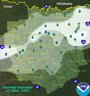
- December 15-16, 1983
- A narrow band of 4-6 inches fell along a line from Weatherford to Denton to Greenville and Paris. Another band of 4-8 inches occurred from Wills Point to Tyler and Gilmer.
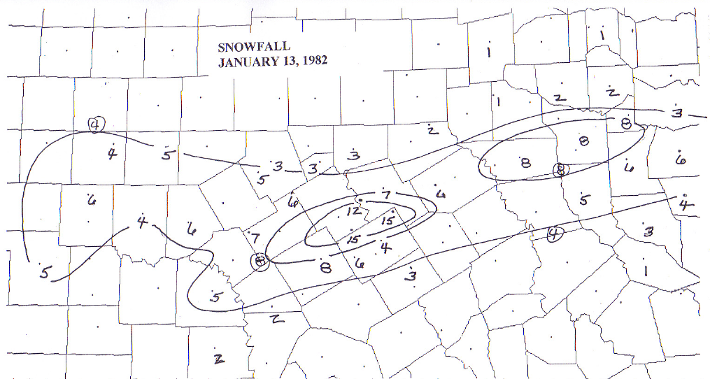
- January 13, 1982
-
Between 6-10 inches fell in a band from Hamilton to Hillsboro to Tyler, with Clifton and Itasca reporting 15 inches for the event. The totals easily place this event among the greatest North Texas snowfalls of the 20th century.
At least four inches fell south of a line through Abilene-Dublin-Corsicana-Longview, and north of a line through San Angelo-San Saba-Marlin-Jacksonville. Only a trace fell in the Dallas/Fort Worth and Temple areas with this event.
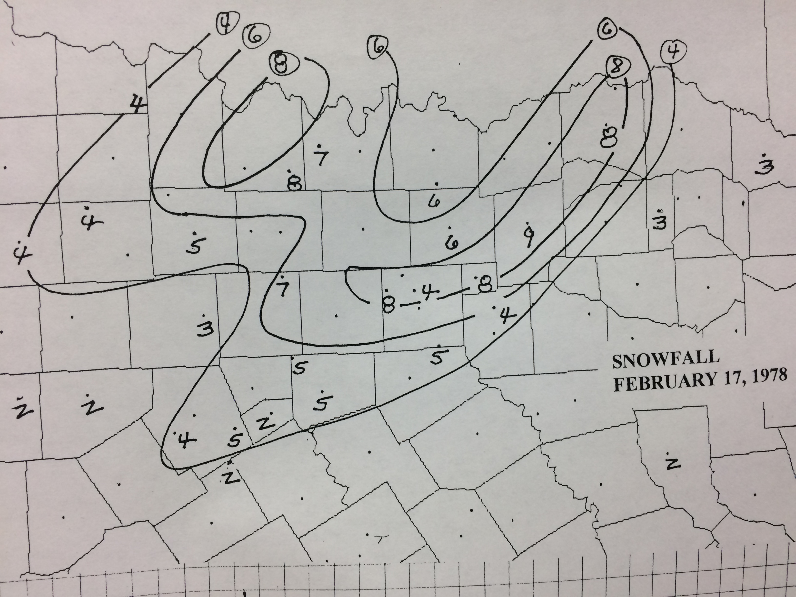
- February 17, 1978
- The last in a series of five snow events that began in mid-January also had the greatest totals. Between 4-8 inches fell from Throckmorton to Gainesville and north of a line through Dublin, Cleburne, Terrell, and Sulphur Springs.
- January 30, 1977
- Almost all of North Texas picked up at least 2 inches of snow with this event. Between 4-6 inches were reported south of the Red River and north of a line through Eastland, Hillsboro, Fairfield, and Tyler.
- November 13-14, 1976
- Widespread 4-6 inch snow fell over much of the northern and western sections of North Texas. The area covered was north of a line through Coleman, Hamilton, Fort Worth, Bonham, and Clarksville. Lampasas also reported 5 inches of snow with this event.
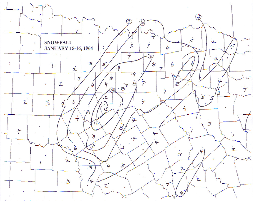
- January 15-16, 1964
- Accumulations above4 inches were reported from stations east of a Muenster-Eastland-Goldthwaite line and west of a Burnett-Temple-Mexia-Canton-Clarksville line. Between 8-12 inches were reported in a broad band from Hamilton to Granbury to McKinney. This was one the Dallas/Fort Worth area's biggest snowfalls.
- January 27-28, 1961
- There was widespread 1-3 inch accumulation over much of North Texas with this event, but a small area of 4-6 inches was reported from Dublin to Mineral Wells to Bridgeport, and from Hico to Cleburne to Waxahachie to Kaufman.
- January 17-18, 1956
- Freezing rain and sleet gradually changed to snow in this event, with widespread 3-5 inch totals over much of the northern half of North Texas. Between 4-6 accumulations were reported east of a line from Sherman to Cleburne, and north of a line from Cleburne to Rockwall to Paris.
- January 22, 1940
- Almost all areas of North Texas saw at least 2 inches of snow with this event. Between 4-6 inches were reported in the counties along the Red River, and over most of the area south of a line through Eastland, Dallas, and Sulphur Springs. The area north of a Lampasas, Cameron, Crockett line also reported at least 4-inch accumulations.
- November 22, 1937
- Between 4-8 inches fell in bands over a large area of North Central Texas. One band occurred from Eastland to Fort Worth, while another occurred from Hamilton to Hillsboro to Kaufman. A broad area of 4-8 inch accumulations occurred from Copperas Cove to Marlin to Palestine, including the Waco and Temple/Killeen areas.
- December 20-21, 1929
- Between 6-12 inches fell over a broad area over the southern half of North Texas, with 12-16 inches falling from Brady to Hillsboro to Longview. Totals reached 24-26 inches from Clifton to Hillsboro, among the highest 24-hour totals ever recorded in Texas. Amounts above 4 inches fell south of a line through Winters, Brownwood, Dublin, Waxahachie, Kaufman, and Atlanta. Only trace amounts fell north of this line, including the Dallas/Fort Worth area.
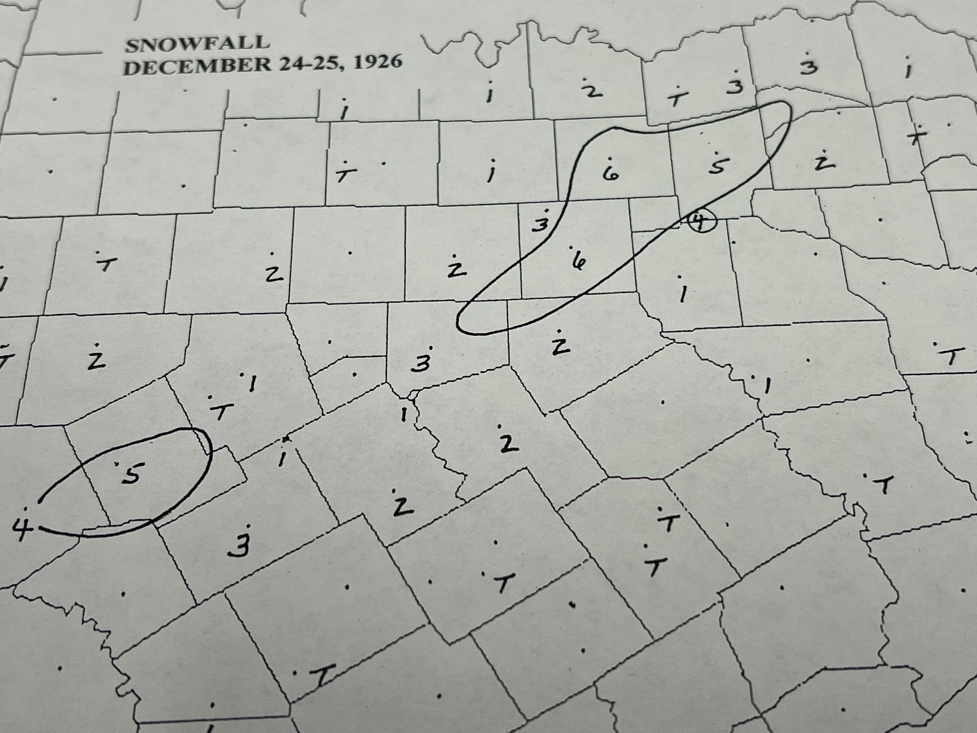
- December 24-26, 1926
- Between 1-2 inches were common over North Texas south of a line from San Angelo to Eastland to Sherman, and north of a line from Lampasas to Hillsboro to Sulphur Springs. Six inches was reported at Dallas, McKinney, and Greenville.
- March 12-13, 1924
- Between 4-8 inches of snow fell over the Red River area, and as far south as Dallas and Fort Worth. Between 8-10 inches were reported at Bowie, Bridgeport, Weatherford and Honey Grove.
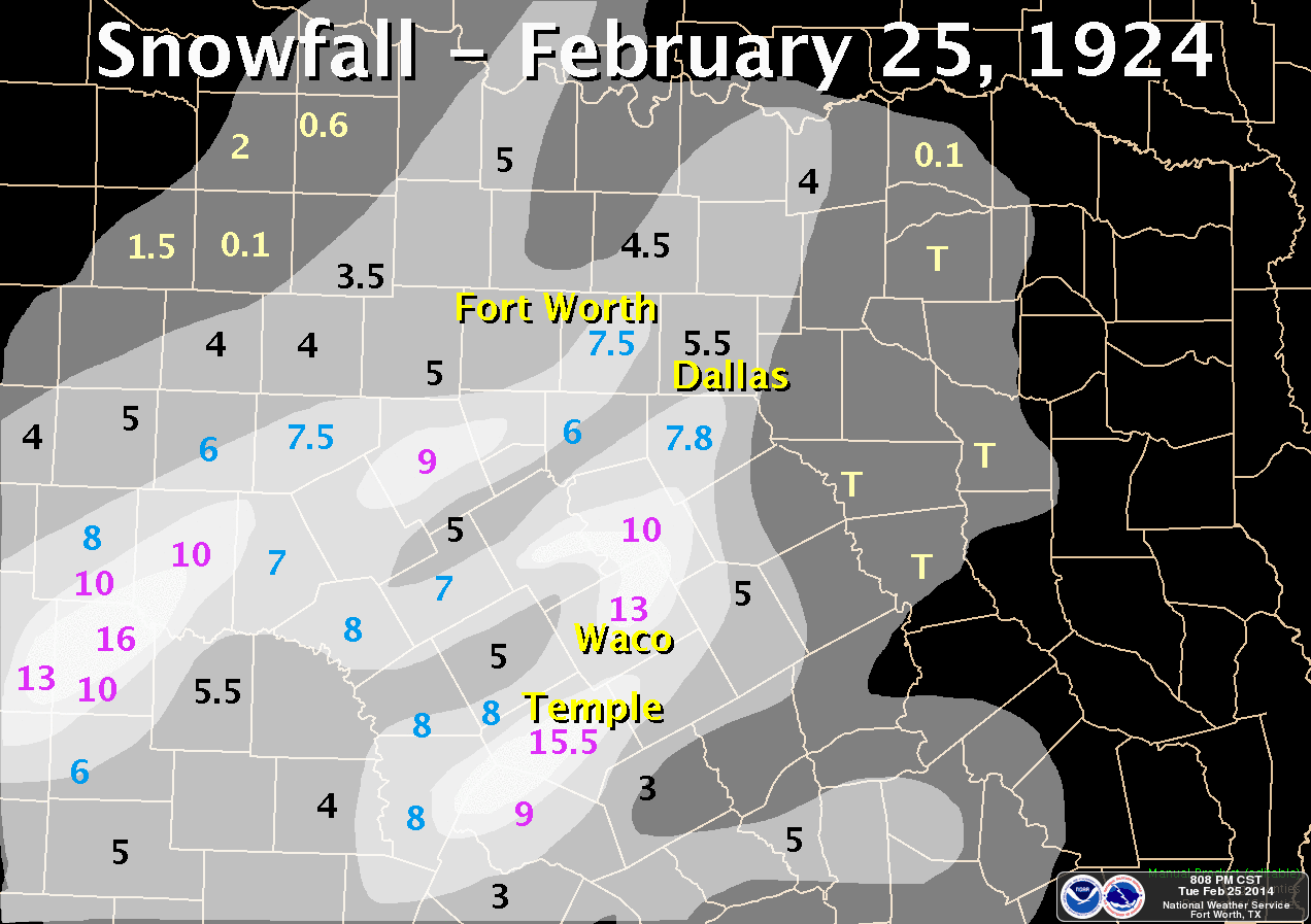
- February 25, 1924
- One of the heaviest snow events on record dumped more than a foot of snow in portions of Central Texas. Temple tallied more than 15 inches, and Waco's 13-inch total remains tied for its highest 24-hour amount on record.
- January 20-21, 1918
- Amounts above four inches fell south of a line through Anson and Henrietta, and north of a line through Winters-Eastland-Fort Worth and Clarksville. Between 6-8 inches fell in a broad band from Putnam to Graham and Gainesville to Sherman.
- January 14-15, 1917
- One of the big north Texas snow events. Between 4-8 inches were widespread over the area north of a line through San Saba, Waxahachie, and Atlanta. The largest totals were eight inches at Weatherford and Fort Worth.
- February 16-17, 1910
- Sleet and snow produced widely varying accumulations across north Texas. Between 4-6 inches fell from Lampasas to Waco, Dallas to Tyler, Sherman to Paris, Sulphur Springs to Mount Pleasant. Elsewhere over north Texas, 1-3 inch totals were common.
- January 4-5, 1910
- Between 4-8 inches fell in a 40-mile wide band from Dublin to Fort Worth to Sherman. Between 1-2 inches fell from Dallas south to Corsicana, and northeast to Sulphur Springs and Clarksville.
- February 15-16, 1903
- Over two inches of snow accumulated over the area north of an Abilene-Dublin-Corsicana-Tyler-Atlanta line. Bands of 4-6 inches were reported along the Red River from Wichita Falls to Bowie to Sherman and Paris, and from Dallas to Greenville.
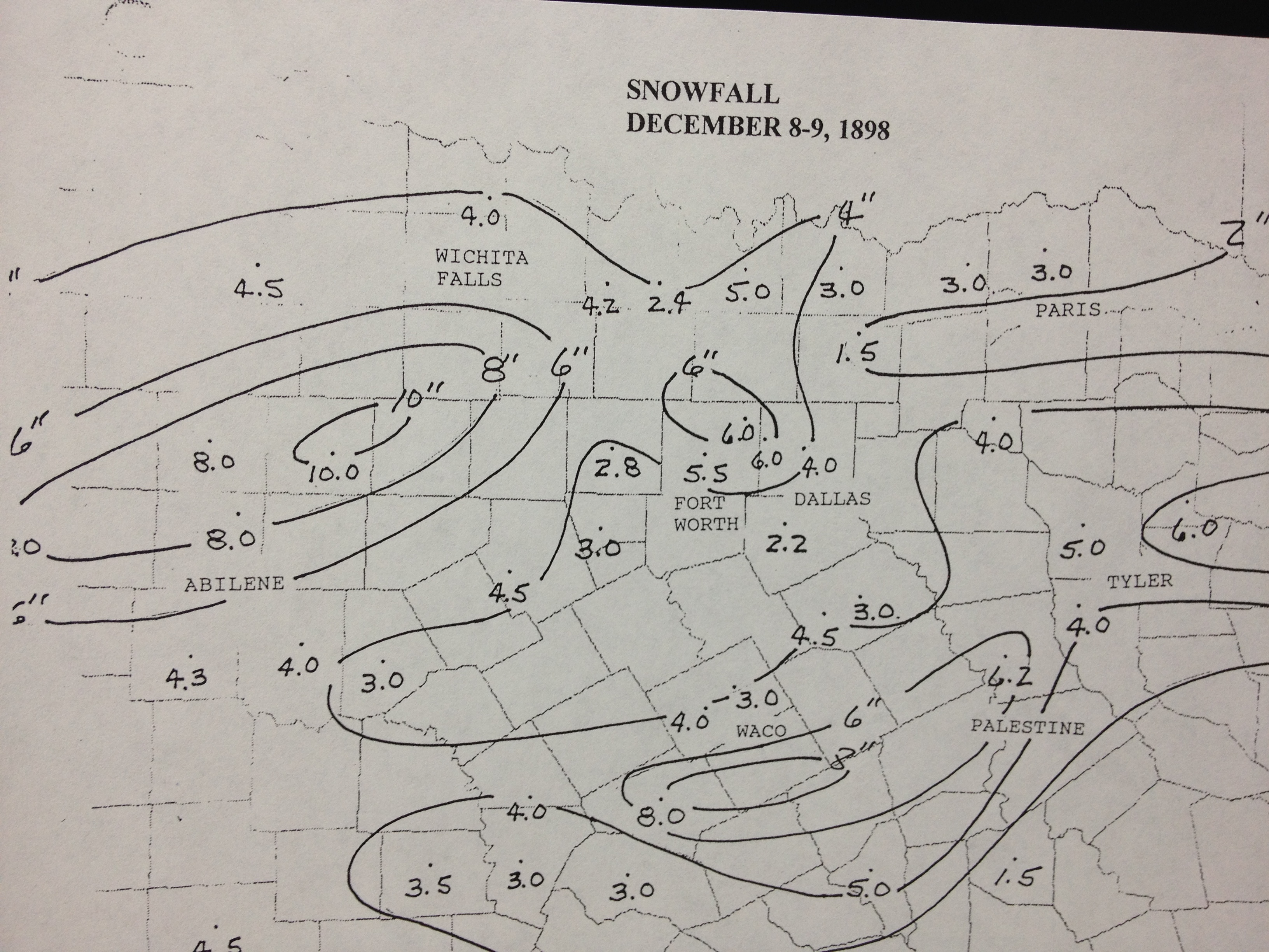
- December 8-9, 1898
- Widespread snow fell over the northern half of the state. Between 6-8 inches fell from Jacksboro to Haskell, and from Temple to Palestine. Between 4-6 inches was reported from the Dallas/Fort Worth Metroplex.
- February 12-15, 1895
- Widespread snow over the state, even as far south as the lower Valley. North Texas received between 3-5 inches, but a band of 10-20 inches blanketed the upper Texas coast, including Houston and Beaumont/Port Arthur.
- December 23-24, 1887
- A severe ice storm occurred on December 23, resulting in numerous downed trees and telegraph lines. Heavy snow followed on Christmas Eve, with as much as 9 inches falling in Palestine.
- December 24-25, 1879
- There was an inch of sleet and snow on the ground on Christmas Day. In one account, the sleet and snow was said to have been so compacted that a horse's hoof did not leave an imprint.
- December 25, 1841
- In the earliest record of a white Christmas in North Texas, soldiers were tracking a bear in 6 inches of snow in what is now Dallas.


