National Weather Service United States Department of Commerce

Early Season Heat Wave in Texas; Thunderstorm and Heavy Rainfall in the Mid-Atlantic and Northern/Central Plains

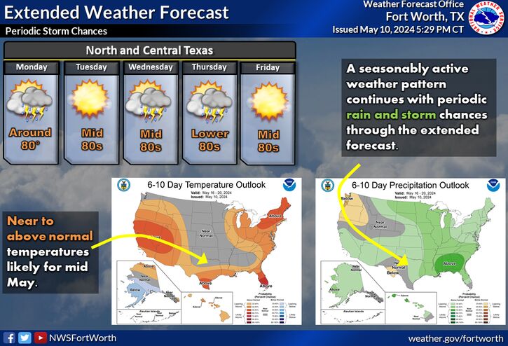
An early season heat wave will bring record-breaking temperatures to parts of Texas through this weekend into next week. Thunderstorms and flooding in the Mid-Atlantic region will continue overnight into Wednesday. Severe thunderstorms and heavy rainfall are possible over parts of the Dakotas and Nebraska Wednesday. Elevated to critical fire conditions continue in the Southern Plains. Read More >

Click a location below for detailed forecast.

Last Map Update: Wed, May 14, 2025 at 4:42:28 am CDT

A Heat Advisory is now in effect from 12 pm through 9 pm Wednesday for Bell, coryell, Falls, Lampasas, McLennan, and Robertson counties in Central Texas. High temperatures will be between 102 and 107 degrees with heat index values up to 110 degrees.
Unseasonably hot weather will continue on Thursday. Some locations may break their daily records by as much as 5 to 7 degrees. Triple digit temperatures will be possible for areas along and west of I-35 and along and south of I-20. Remember to stay hydrated and take frequent breaks in the shade or A/C! Wear light-colored clothing, and know the signs of heat-related illness.
Above normal temperatures will continue through the end of the week with afternoon highs in the low to mid 90s. Storm chances will increase late this week and weekend. Some severe weather is expected.
Above average temperatures will continue into Thursday, with afternoon highs in the upper 80s and low 90s across the region. There will be a dryline draped across the region from southeast Oklahoma into central Texas. There is a very low (10 to 20%) chance for a stray thunderstorm or two to develop along this boundary in northeast Texas during the afternoon and evening hours. Should they develop, thunderstorms may be on the stronger side given the unstable airmass in place. The primary hazards would be large hail and isolated instances of damaging winds.

Text Product Selector (Selected product opens in current window)
Latest Text Products Issued (Experimental)
Safe Rooms Icon Cooperatirve Rainfall (CoCoRaHs) icon Storm Ready Icon AirNow Icon