
A few severe thunderstorms with large hail and damaging winds are possible this evening into tonight from eastern Kansas into western and central Missouri. Thunderstorms with heavy to excessive rainfall may produce flooding through tonight over parts of the northern High Plains, central Missouri, and along the Florida/Georgia line. Read More >
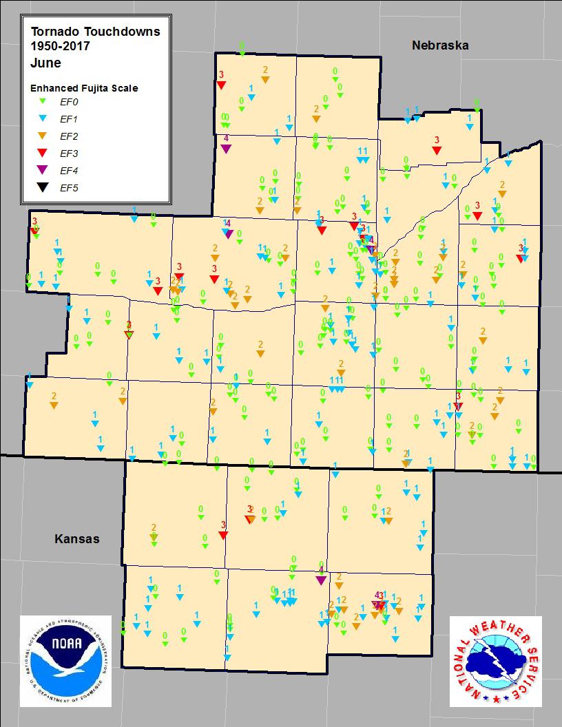
June Tornadoes
South Central Nebraska and North Central Kansas
(1950-2017)
| Tornado Touchdowns | Tornado Tracks |
 |
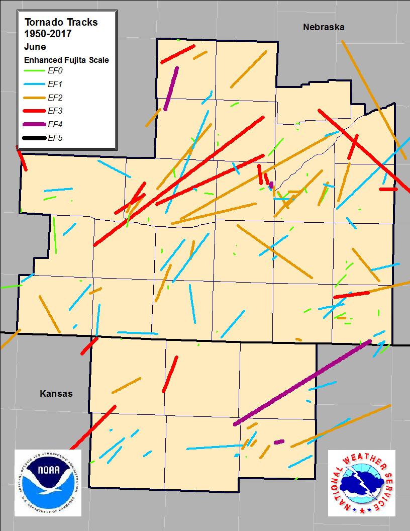 |
Tornado Descriptions (EF3 and Greater)
F4/EF4:
- June 15, 1992
Mitchell County: A supercell thunderstorm rotated across the county for nearly three hours and dropped numerous (12) tornadoes. In an area 15 miles wide and 25 miles long, 81 different farms sustained damage to buildings. A total of nine farm homes were completely destroyed, and many others had major damage. A farmer living south of Cawker City, KS reported going to the basement in his farm home five different times during the evening, and each time he came out of the basement, his farm had additional damage. He also reported that at one time, he counted three tornadoes on the ground, and four in the air. This supercell also dropped tornadoes across Osborne, Jewell, Ottawa and Cloud Counties.
- June 3, 1980
Hall County: Multiple tornadoes, including the city of Grand Island. Follow the above link for more information.
- June 6, 1956
Buffalo County: A tornado tracked southeast, passing three miles north of Pleasanton, NE. Two farms were severely damaged. A house and five buildings were destroyed. Dead chickens were scattered for a half mile. There was one injury.
- June 4, 1955
Osborne County: The tornado moved north from two miles north of Downs, KS, passing through 'Dispatch.' Homes were damaged or destroyed on 10 farms, and there were four injuries.
- June 7, 1953
Sherman County: A tornado moved northeast from south of Arcadia, NE, passing three miles east of town. Eleven peope were killed and five people were injured. Ten of the fatalities were members of a family killed during a reunion. A car was carried on quarter mile through the air. There was F4 damage to three homes near Arcadia, and one in the Hays Creek area. The tornado was said that it looked like a 'whip lashing the ground.
F3/EF3
- June 20, 2011
Buffalo County: Several tornadoes occurred across the area, including an EF3 in western Buffalo county. This tornado narrowly missed the town of Amherst by approximately two miles. Shortly after this tornado developed, a home was significantly damaged, and large transmission lines were knocked down as it crossed Highway 40. As it continued northeast, one home was completely destroyed, along with additional outbuildings, trees, and irrigation pivots.
Polk County: A second EF3 tornado tracked from east of Polk, NE to 6 miles west-northwest of Osceola, NE. Residences near Highway 66 suffered significant roof, window and tree damage, and a combine was tossed about 100 yeards into a field. The most significant damage occurred at a farmstead on Highway 92 that took a direct hit. The home and surrounding outbuildings were either destroyed or significantly damaged.
- June 3, 1999
Valley County: Late in the evening, a severe thunderstorm produced a large tornado across northwest Valley County. The tornado touched down 12 miles west of Ord, NE, after 11 pm, and snaked its way northeast before lifting after midnight about seven miles north of Ord. The tornado had a damage path almost one half mile wide at one point. It completely destroyed two farmsteads, and damaged two others along its path. The tornado tossed cars and farm equipment up to 300 feet, strewn irrigation pipe across the countryside, and killed livestock.
- June 6, 1993
Dawson, Buffalo, Phelps Counties: A family of multiple vortex tornadoes, started four miles north of Bertrand, NE and struck an airstrip. A hangar and plane sustained damage. The tornado moved north and hit a truck stop near Overton. The tornado moved into western Buffalo County and was nearly stationary in the Amherst area for almost 90 minutes. Five funnels were noted with this storm. The tornado moved east northeast across Buffalo County to Ravenna, then into southeast Sherman County, and finally into Howard County near Boelus and Dannebrog. The tornado was last seen to the northeast of St. Paul, near Cushing. Along its 60 mile path, 97 homes were damaged and three were destroyed. Two childred received cuts from flying glass as their home was destroyed at Ravenna.
- June 12, 1984
Thayer County: A tornado touched down three miles south of Davenport, NE and moved east for 13 miles to two miles south of Bruning. Five farms were heavily damaged southwest and south of Bruning, injuring five people. Many power lines, trees, fences, and outbuildings were heavily damaged on other farmsteads along the path.
- June 11, 1984
Hall County: The tornado touched down near Cairo, NE and tracked northeast for 14 miles through St. Libory. The tornado caused extensive damage to outbuildings, power lines and trees. St. Libory was the hardest hit, with several homes and buildings receiving major damage. Railroad cars were blown off of the tracks. Many trees were downed and some buildings were damaged at Cairo.
- June 18, 1975
Dawson County: A severe thunderstorm moving almost due north at 20-30 mph, spawned eight tornadoes and numerous funnels over a 10 county area of south central Nebraska. At times there were as many as three tornadoes on the ground at the same time. The path was nearly continuous, being broken only where one tornado spun off and another developed. In Dawson County, the tornado tracked along the county line, leveling barns and killing livestock as it passed just west of Gothenburg.
- June 15, 1975
Nance County: The tornado had a 65 mile path, beginning two and a half miles south of Fullerton, NE, tracking southeast. It passed five miles southwest of Osceola, near Gresham, five miles north of Utica, and ended just southeast of Milford. It damaged a considerable amount of farm equipment, grain bins, fences, trees, gasoline storage tanks, signs, and windows.
- June 21, 1957
York County: A tornado moved east northeast from two miles northeast of Waco, NE to northeast of Utica. Sixteen farms lost barns or other outbuildings in the three mile wide tornado and thunderstorm downburst damage area.
- June 15, 1957
Phillips/Smith County line: The tornado moved north northeast from four miles south southwest of Kensington, KS, cutting across the west side of town, and ending 10 miles north northeast of town. a few homes were totally destroyed and and dozens of homes were unroofed.

