
A significant heat wave continues for the Rockies, Northern Plains, and Great Lakes into the Mid-Atlantic, peaking in intensity through midweek and lingering across parts of the Northern Plains and Midwest until this weekend. Excessive rainfall my bring life-threatening and locally catastrophic flash and urban flooding across portions of southwestern Texas through early Friday. Read More >
Overview:
(BE SURE TO CLICK THE VARIOUS TABS BELOW FOR A VARIETY OF JULY 2017 CLIMATE INFORMATION!)
|
Recap of July 2017 Weather for the NWS Hastings Coverage Area: While there were no truly major flooding events during the month, a widespread swath of 2-5" of rain targeted portions of mainly Franklin, Webster, Nuckolls and southern Kearney counties on the 17th, causing mainly minor/short-term flooding issues within those counties and also allowing the Republican River to breach minor flood stage per the automated gauge near Guide Rock.
|
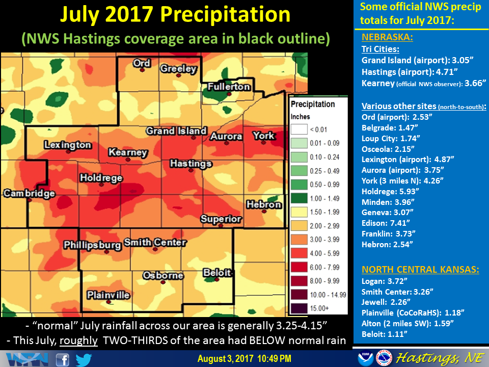 This graphic features a precipitation map for July 2017, along with a partial listing of totals from official NWS stations. (Click image to enlarge) |
Grand Island & Hastings Details (Including 12-Month History):
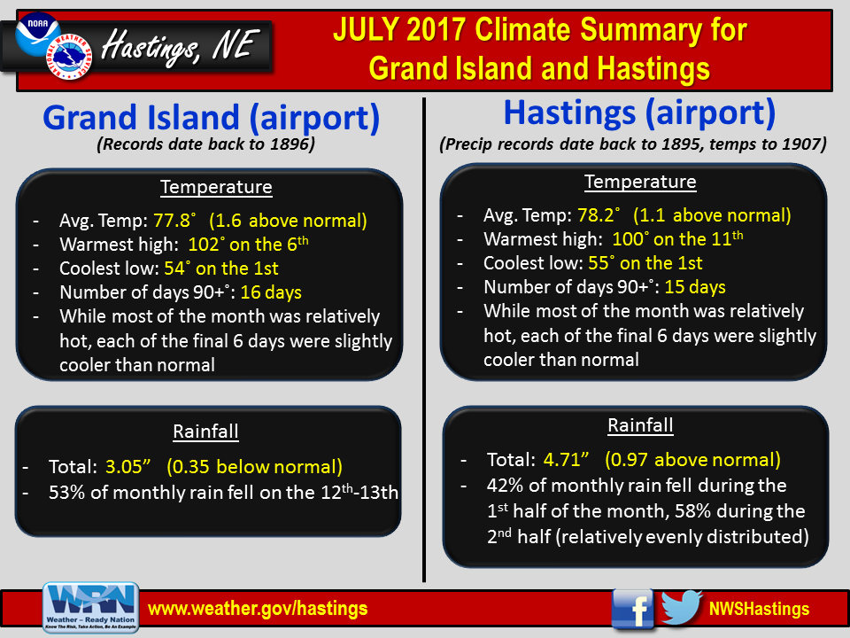 |
| Detailed July 2017 info for Grand Island/Hastings (Click to enlarge) |
 |
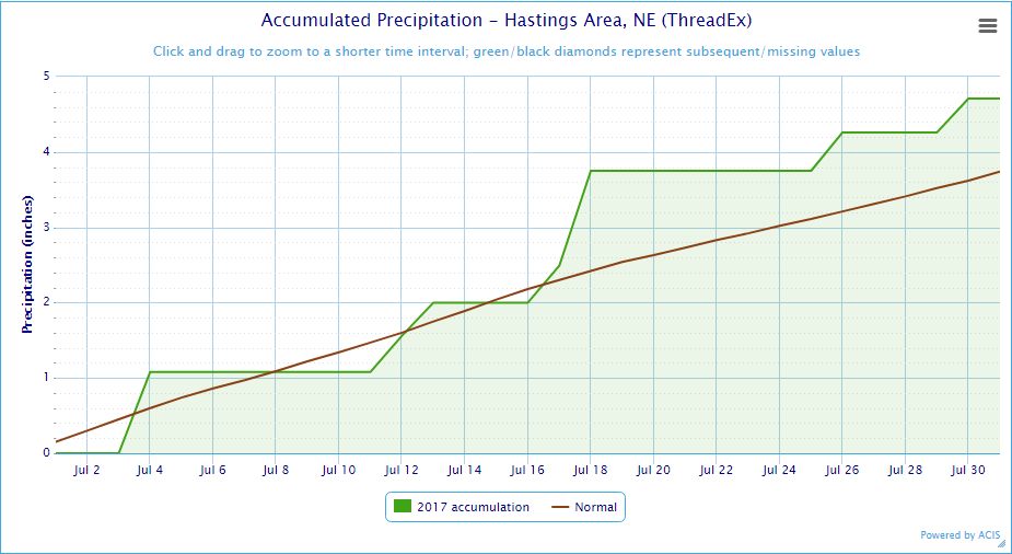 |
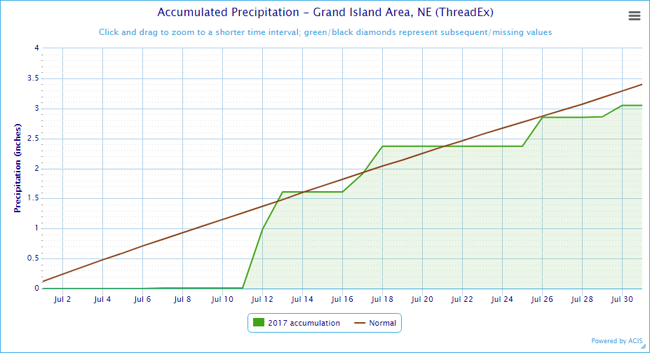
| Grand Island Precipitation Summary: The green line indicates cumulative observed precipitation for July 2017.The brown line indicates "normal" July precipitation based on 30-year data from 1981-2010. (click to enlarge) | Hastings Precipitation Summary: The green line indicates cumulative observed precipitation for July 2017. The brown line indicates "normal" July precipitation based on 30-year data from 1981-2010. (click to enlarge) |
| Grand Island (Regional Airport ASOS) - August 2016 - July 2017 | ||||||||||||
| Aug. | Sep. | Oct. | Nov. | Dec. | Jan. | Feb. | Mar. | Apr. | May | June | July | |
| Average High (F) | 84.4 | 78.8 | 70.7 | 57.3 | 37.3 | 34.6 | 50.8 | 54.4 | 63.1 | 72.7 | 87.5 | 88.9 |
| Average Low (F) | 62.7 | 55.0 | 42.6 | 32.7 | 14.5 | 17.9 | 24.8 | 30.0 | 39.2 | 49.6 | 61.2 | 66.6 |
| Average Temperature (F) | 73.5 | 66.9 | 56.7 | 45.0 | 25.9 | 26.3 | 37.8 | 42.2 | 51.1 | 60.3 | 74.4 | 77.8 |
| Departure From Normal | -0.5 | +1.8 | +4.5 | +6.9 | -0.8 | +1.2 | +8.7 | +2.8 | +0.5 | -0.9 | +3.1 | +1.6 |
| Precipitation (in) | 0.57 | 2.53 | 0.12 | 1.37 | 0.81 | 1.07 | 0.25 | 0.81 | 2.64 | 5.28 | 2.10 | 3.05 |
| Departure From Normal | -2.55 | +0.30 | -1.74 | +0.20 | +0.18 | +0.54 | -0.43 | -0.99 | +0.11 | +0.87 | -2.20 | -0.35 |
| Snowfall (in) | 0.0 | 0.0 | 0.0 | 0.4 | 1.4 | 2.4 | 3.5 | 1.2 | T | 0.3 | 0.0 | 0.0 |
| Departure From Normal | 0.0 | -0.1 | -1.0 | -2.7 | -3.7 | -4.1 | -2.8 | -4.2 | -1.5 | +0.3 | 0.0 | 0.0 |
| Hastings (Municipal Airport ASOS) - August 2016 - July 2017 | ||||||||||||
| Aug. | Sep. | Oct. | Nov. | Dec. | Jan. | Feb. | Mar. | Apr. | May | June | July | |
| Average High (F) | 84.9 | 78.6 | 71.3 | 57.4 | 37.7 | 35.7 | 51.4 | 55.4 | 63.4 | 72.8 | 86.3 | 88.9 |
| Average Low (F) | 63.4 | 56.1 | 44.0 | 34.2 | 15.6 | 19.4 | 25.8 | 31.3 | 40.7 | 49.5 | 62.1 | 67.6 |
| Average Temperature (F) | 74.1 | 67.3 | 57.6 | 45.8 | 26.6 | 27.6 | 38.6 | 43.4 | 52.1 | 61.1 | 74.2 | 78.2 |
| Departure From Normal (F) | -0.2 | +1.7 | +5.0 | +7.1 | -1.0 | +1.6 | +8.7 | +3.5 | +1.4 | -0.2 | +2.4 | +1.1 |
| Precipitation (in) | 1.77 | 1.80 | 0.22 | 1.46 | 0.61 | 0.83 | 0.27 | 1.08 | 3.24 | 6.42 | 1.79 | 4.71 |
| Departure From Normal (in) | -1.53 | -0.76 | -1.77 | +0.17 | 0.00 | +0.42 | -0.22 | -0.71 | +0.68 | +1.85 | -2.01 | +0.97 |
| Snowfall (in) | 0.0 | 0.0 | 0.0 | 0.1 | 1.0 | 3.7 | 4.3 | 1.2 | 0.2 | 0.6 | 0.0 | 0.0 |
| Departure From Normal (in) | 0.0 | -0.2 | -1.0 | -2.5 | -5.1 | -2.3 | -2.2 | -4.0 | -1.0 | +0.6 | 0.0 | 0.0 |
Kearney - 12 Month Climate History:
All data here is from the official NWS observer at Kearney airport, with 24-hour observations taken around 7 a.m. ** PLEASE NOTE: This official Kearney data differs somewhat from the unofficial data recorded by the automated airport system (KEAR) **
| Kearney Airport (Coop Observer) - August 2016 - July 2017 | ||||||||||||
| Aug. | Sep. | Oct. | Nov. | Dec. | Jan. | Feb. | Mar. | Apr. | May | June | July | |
| Average High (F) | 84.3 | 79.3 | 70.8 | 58.6 | 37.8 | 36.9 | 50.0 | 54.6 | 62.5 | 70.2 | 86.6 | 88.1 |
| Average Low (F) | 61.8 | 53.0 | 40.8 | 33.4 | 14.8 | 19.5 | 24.1 | 28.6 | 38.8 | 45.9 | 59.7 | 64.8 |
| Average Temperature (F) | 73.1 | 66.2 | 55.8 | 46.0 | 26.3 | 28.2 | 37.1 | 41.6 | 50.7 | 58.1 | 73.2 | 76.5 |
| Departure From Normal (F) | +0.5 | +2.7 | +4.9 | +9.0 | +0.4 | +3.6 | +9.0 | +3.9 | +2.0 | -1.4 | +3.4 | +1.8 |
| Precipitation (in) | 1.47 | 1.20 | 0.12 | 1.56 | 0.90 | 0.90 | 0.30 | 1.63 | 1.87 | 6.03 | 1.93 | 3.66 |
| Departure From Normal (in) | -1.61 | -0.87 | -1.92 | +0.54 | +0.33 | +0.41 | -0.25 | -0.16 | -0.36 | +1.85 | -2.00 | +0.38 |
| Snowfall (in) | 0.0 | 0.0 | 0.0 | 0.2 | 1.0 | 4.5 | 5.2 | 0.7 | T | 1.6 | 0.0 | 0.0 |
| Departure From Normal (in) | 0.0 | -0.2 | -0.7 | -2.9 | -2.5 | +0.1 | +0.1 | -3.9 | -1.8 | +1.6 | 0.0 | 0.0 |
Ord - 12 Month Climate History:
Winter precipitation totals often include NWS Cooperative Observer data due to the automated airport equipment under-measuring snowfall liquid equivalent.
| Ord (Evelyn Sharp Field Airport ASOS) - August 2016 - July 2017 | ||||||||||||
| Aug. | Sep. | Oct. | Nov. | Dec. | Jan. | Feb. | Mar. | Apr. | May | June | July | |
| Average High (F) | 83.6 | 77.2 | 70.3 | 56.7 | 37.6 | 34.1 | 48.4 | 53.7 | 61.7 | 69.7 | 86.3 | 90.3 |
| Average Low (F) | 60.4 | MSG | 37.4 | 28.1 | 9.3 | 14.2 | 19.8 | 28.7 | 37.9 | 44.1 | 56.9 | 64.1 |
| Average Temperature (F) | 72.0 | MSG | 53.8 | 42.4 | 23.5 | 24.1 | 34.1 | 41.2 | 49.8 | 56.9 | 71.6 | 77.2 |
| Departure From Normal (F) | -1.0 | MSG | +4.2 | +6.1 | -1.4 | -0.5 | +6.3 | +3.5 | +1.0 | -2.4 | +2.4 | +2.8 |
| Precipitation (in) | 0.44 | 1.70 | 0.09 | 1.26 | 0.41 | 1.15 | 0.79 | 1.83 | 4.25 | 3.10 | 0.59 | 2.53 |
| Departure From Normal (in) | -2.72 | -0.74 | -1.84 | +0.19 | -0.18 | +0.78 | +0.35 | +0.38 | +1.66 | -0.71 | -3.53 | -0.44 |
| Snowfall (in) | 0.0 | 0.0 | 0.0 | 3.0 | 2.7 | 11.9 | 10.4 | 1.9 | 1.0 | 6.0 | 0.0 | 0.0 |
| Departure From Normal (in) | 0.0 | 0.0 | -1.1 | -2.3 | -4.7 | +5.1 | +4.4 | -4.0 | -1.5 | +6.0 | 0.0 | 0.0 |
Smith Center, KS - 12 Month Climate History:
All data is from the official NWS observer, with 24-hour observations taken around 7 a.m. As a result, data may vary slightly from true "Calendar Day" totals.
| Smith Center KS (NWS Coop Observer) - August 2016 - July 2017 | ||||||||||||
| Aug. | Sep. | Oct. | Nov. | Dec. | Jan. | Feb. | Mar. | Apr. | May | June | July | |
| Average High (F) | 86.5 | 81.3 | 73.9 | 61.0 | 38.7 | 39.0 | 53.4 | 58.5 | 65.4 | 73.9 | 89.8 | 95.2 |
| Average Low (F) | 62.8 | 55.6 | 43.5 | 32.9 | 14.2 | 18.5 | 24.2 | 30.2 | 40.0 | 46.8 | 60.9 | 66.7 |
| Average Temperature (F) | 74.7 | 68.5 | 58.7 | 47.0 | 26.5 | 28.7 | 38.8 | 44.4 | 52.7 | 60.4 | 75.4 | 80.9 |
| Departure From Normal (F) | -2.5 | +0.3 | +3.9 | +6.6 | -2.3 | +1.0 | +6.8 | +2.8 | +0.2 | -3.3 | +1.4 | +1.2 |
| Precipitation (in) | 5.13 | 5.07 | 0.09 | 0.99 | 0.56 | 1.46 | 0.27 | 1.26 | 3.32 | 7.03 | 1.31 | 3.26 |
| Departure From Normal (in) | +1.83 | +3.03 | -1.79 | -0.23 | -0.10 | +0.97 | -0.31 | -0.61 | +1.05 | +3.11 | -2.30 | -0.61 |
| Snowfall (in) | 0.0 | 0.0 | 0.0 | 0.0 | 3.1 | 1.1 | 1.8 | 0.2 | 0.0 | 0.0 | 0.0 | 0.0 |
| Departure From Normal (in) | 0.0 | -0.2 | -0.4 | -1.8 | -0.1 | -2.6 | -2.3 | -2.4 | -0.6 | 0.0 | 0.0 | 0.0 |
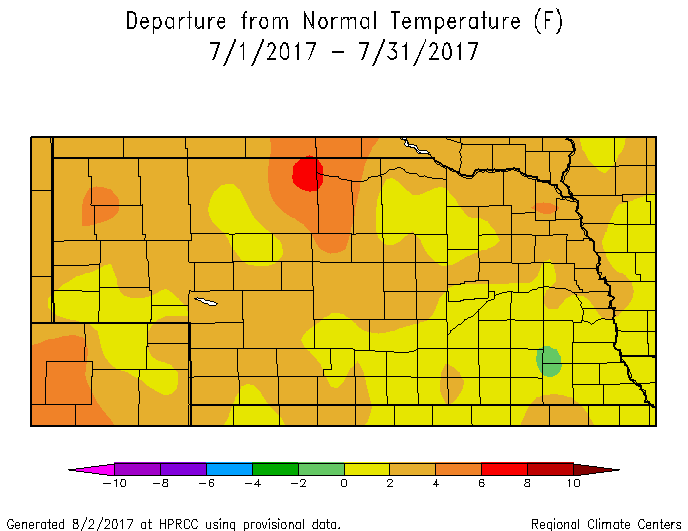
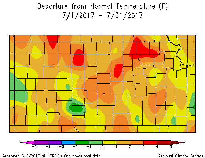
Area Temperature & Precipitation Departure From Normal Maps:
These images depict July 2017 monthly temperature departure from normal & precipitation percent-of-normal for both Nebraska & Kansas. Images are courtesy of the High Plains Regional Climate Center (HPRCC). Click images to enlarge.
 |
 |
 |
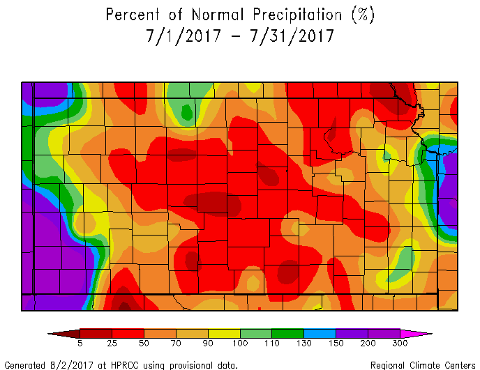 |
| Departure from Normal Temperature - NE (left) & KS (right) | Percent of Normal Precipitation - NE (left) & KS (right) | ||
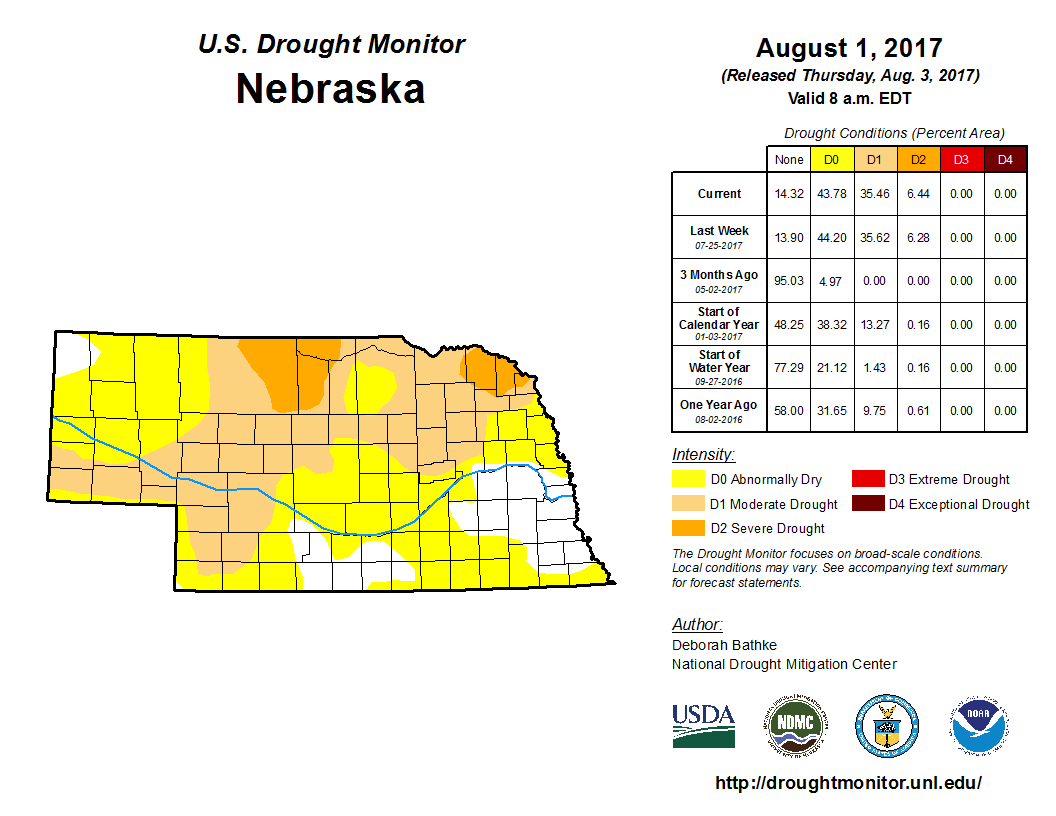
Drought:
The following drought images, current as of August 1, 2017, are courtesy of the U.S. Drought Monitor
Brief summary of changes during July for the NWS Hastings coverage area:
Given that roughly two-thirds of the NWS Hastings coverage area received at least slightly below normal July rainfall (and some areas well-below normal), drought classification at month's was generally similar to slightly-worse than one month prior for the area as a whole, although some improvement was noted in those limited areas that received solidly above-normal rain.
More specifically, the worst conditions, assigned Moderate Drought (D1), expanded to include portions of the following counties: Valley, Greeley, Nance, Smith, Osborne, Jewell, Mitchell. Meanwhile, the majority of the area remained status quo in Abnormally Dry (D0) status. On the positive side of things, above-normal July rainfall resulted in the majority of the following counties being removed from all drought categories whatsoever: Gosper, Kearney, Furnas, Harlan, Franklin, Webster and York.
 |
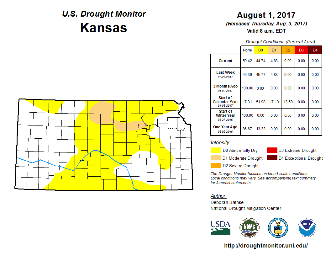 |
| Drought Monitor for Nebraska (left) & Kansas (right). Valid as of August 1, 2017 (click to enlarge) | |
Monthly Extremes for the NWS Hastings Coverage Area:
...A FEW OF THE HOTTEST HIGH TEMPERATURES DURING JULY 2017...
(all data from NWS cooperative observers or automated airport sites)
111 degrees...Webster Dam, KS
109 degrees...4 WNW Plainville, KS
108 degrees...2 SW Alton, KS - Smith Center, KS
107 degrees...Kirwin Dam, KS
106 degrees...Glen Elder Dam, KS - Beaver City
...A FEW OF THE COOLEST LOW TEMPERATURES DURING JULY 2017...
(all data from NWS cooperative observers or automated airport sites)
48 degrees...Edison - Greeley - Ord Airport ASOS
50 degrees...Gothenburg - Beaver City - 6 NNW Oxford - Ravenna
51 degrees...Franklin
52 degrees...Lexington Airport AWOS - Red Cloud - Loup City - Webster Dam, KS
...A FEW OF THE HIGHEST MONTHLY RAINFALL TOTALS DURING JULY 2017...
(all data from NWS cooperative observers or automated airport sites unless specified)
7.41 inches...Edison
6.87 inches...Wilcox (NeRAIN Observer)
6.63 inches...York (NeRAIN Observer)
5.93 inches...Holdrege
4.67 inches...4 N Aurora
...A FEW OF THE LOWEST MONTHLY RAINFALL TOTALS DURING JULY 2017...
(all data from NWS cooperative observers or automated airport sites unless specified)
0.98 inch...Natoma
1.10 inches...Bruning
1.11 inches...Beloit, KS
1.43 inches...Gothenburg
1.46 inches...St. Paul
 |
Media use of NWS Web News Stories is encouraged! Please acknowledge the NWS as the source of any news information accessed from this site. |
|

