
A significant heat wave continues for the Rockies, Northern Plains, and Great Lakes into the Mid-Atlantic, peaking in intensity through midweek and lingering across parts of the Northern Plains and Midwest until this weekend. Excessive rainfall my bring life-threatening and locally catastrophic flash and urban flooding across portions of southwestern Texas through early Friday. Read More >
Overview/Narrative:
(BE SURE TO CLICK THE VARIOUS TABS BELOW FOR A VARIETY OF JUNE 2018 CLIMATE INFORMATION!)
|
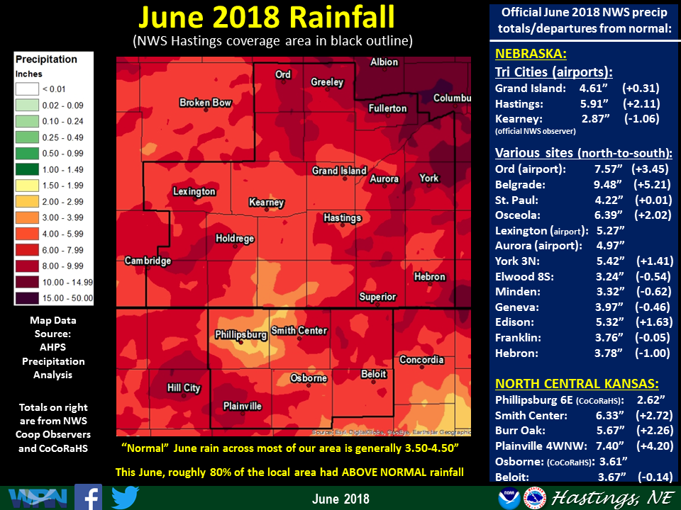
Recap of June 2018 Weather for the 30-county NWS Hastings Coverage Area:
|
Grand Island & Hastings Details (Including 12-Month History):
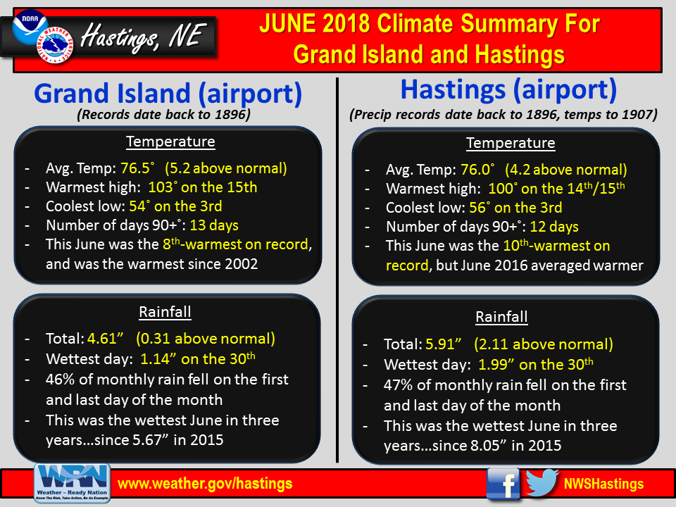 |
| Detailed June 2018 info for Grand Island/Hastings (Click to enlarge) |
 |
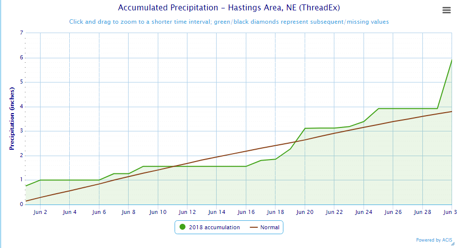 |
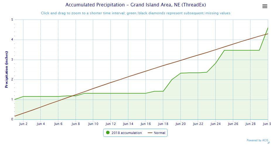
| Grand Island Precipitation Summary: The green line indicates cumulative observed precipitation for June 2018.The brown line indicates "normal" June precipitation based on 30-year data from 1981-2010. (click to enlarge) | Hastings Precipitation Summary: The green line indicates cumulative observed precipitation for June 2018. The brown line indicates "normal" June precipitation based on 30-year data from 1981-2010. (click to enlarge) |
| Grand Island (Regional Airport ASOS) - July 2017 - June 2018 | ||||||||||||
| July | Aug. | Sep. | Oct. | Nov. | Dec. | Jan. | Feb. | Mar. | Apr. | May | June | |
| Average High (F) | 88.9 | 81.3 | 80.5 | 65.2 | 53.4 | 37.3 | 34.0 | 33.6 | 51.8 | 55.4 | 78.6 | 88.2 |
| Average Low (F) | 66.6 | 58.9 | 55.0 | 40.2 | 28.7 | 16.0 | 13.5 | 12.5 | 28.8 | 30.8 | 55.5 | 64.8 |
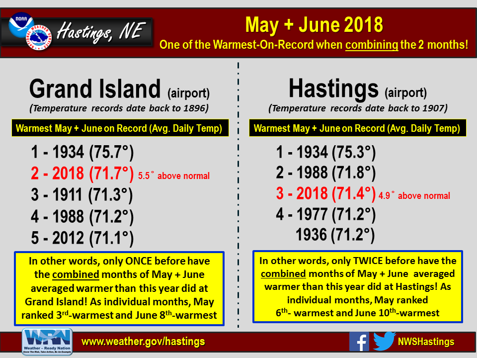
| Average Temperature (F) | 77.8 | 70.1 | 67.8 | 52.7 | 41.1 | 26.6 | 23.7 | 23.1 | 40.3 | 43.1 | 67.0 | 76.5 |
| Departure From Normal | +1.6 | -3.9 | +2.7 | +0.5 | +3.0 | -0.1 | -1.4 | -6.0 | +0.9 | -7.5 | +5.8 | +5.2 |
| Precipitation (in) | 3.05 | 6.19 | 2.68 | 5.36 | 0.51 | 0.45 | 1.08 | 0.75 | 1.26 | 1.26 | 3.98 | 4.61 |
| Departure From Normal | -0.35 | +3.07 | +0.45 | +3.50 | -0.66 | -0.18 | +0.55 | +0.07 | -0.54 | -1.27 | -0.43 | +0.31 |
| Snowfall (in) | 0.0 | 0.0 | 0.0 | 0.9 | 0.2 | 7.2 | 10.2 | 10.6 | 0.4 | 4.1 | 0.0 | 0.0 |
| Departure From Normal | 0.0 | 0.0 | -0.1 | -0.1 | -2.9 | +2.1 | +3.7 | +4.3 | -5.0 | +2.6 | 0.0 | 0.0 |
| Hastings (Municipal Airport ASOS) - July 2017 - June 2018 | ||||||||||||
| July | Aug. | Sep. | Oct. | Nov. | Dec. | Jan. | Feb. | Mar. | Apr. | May | June | |
| Average High (F) | 88.9 | 81.7 | 81.2 | 64.9 | 53.1 | 37.9 | 35.3 | 34.3 | 52.3 | 55.6 | 78.2 | 87.0 |
| Average Low (F) | 67.6 | 59.8 | 55.9 | 40.8 | 28.6 | 15.9 | 14.3 | 12.4 | 27.8 | 30.6 | 55.6 | 65.0 |
| Average Temperature (F) | 78.2 | 70.7 | 68.6 | 52.9 | 40.9 | 26.9 | 24.8 | 23.4 | 40.1 | 43.1 | 66.9 | 76.0 |
| Departure From Normal | +1.1 | -3.6 | +3.0 | +0.3 | +2.2 | -0.7 | -1.2 | -6.5 | +0.2 | -7.6 | +5.6 | +4.2 |
| Precipitation (in) | 4.71 | 5.10 | 2.18 | 4.69 | 0.08 | 0.28 | 0.49 | 0.53 | 1.07 | 1.26 | 3.83 | 5.91 |
| Departure From Normal | +0.97 | +1.80 | -0.38 | +2.70 | -1.21 | -0.33 | +0.08 | +0.04 | -0.72 | -1.30 | -0.74 | +2.11 |
| Snowfall (in) | 0.0 | 0.0 | 0.0 | 0.2 | 0.0 | 5.8 | 5.9 | 8.0 | 0.3 | 6.9 | 0.0 | 0.0 |
| Departure From Normal | 0.0 | 0.0 | -0.2 | -1.0 | -2.6 | -0.3 | -0.1 | +1.5 | -4.9 | +5.7 | 0.0 | 0.0 |
Kearney - 12 Month Climate History:
All data here is from the official NWS observer at Kearney airport, with 24-hour observations taken around 7 a.m. ** PLEASE NOTE: This official Kearney data often differs slightly from the unofficial data recorded by the automated airport system (KEAR) **
| Kearney Airport (Coop Observer) - July 2017 - June 2018 | ||||||||||||
| July | Aug. | Sep. | Oct. | Nov. | Dec. | Jan. | Feb. | Mar. | Apr. | May | June | |
| Average High (F) | 88.1 | 81.2 | 80.7 | 65.9 | 52.3 | 38.7 | 32.2 | 32.9 | 51.9 | 53.8 | 75.9 | 86.6 |
| Average Low (F) | 64.8 | 56.9 | 52.6 | 40.0 | 26.8 | 15.5 | 11.1 | 10.6 | 26.1 | 28.6 | 52.7 | 62.9 |
| Average Temperature (F) | 76.5 | 69.1 | 66.6 | 53.0 | 39.6 | 27.1 | 21.6 | 21.7 | 39.0 | 41.2 | 64.3 | 74.7 |
| Departure From Normal | +1.8 | -3.5 | +3.1 | +2.1 | +2.6 | +1.2 | -3.0 | -6.4 | +1.3 | -7.5 | +4.8 | +4.9 |
| Precipitation (in) | 3.66 | 3.65 | 2.19 | 2.83 | 0.34 | 0.21 | 0.96 | 0.73 | 1.05 | 2.03 | 5.56 | 2.87 |
| Departure From Normal (in) | +0.38 | +0.57 | +0.12 | +0.79 | -0.68 | -0.36 | +0.47 | +0.18 | -0.74 | -0.20 | +1.38 | -1.06 |
| Snowfall (in) | 0.0 | 0.0 | 0.0 | 0.0 | 0.4 | 4.3 | 6.8 | 9.2 | 0.7 | 9.7 | 0.0 | 0.0 |
| Departure From Normal (in) | 0.0 | 0.0 | -0.2 | -0.7 | -2.7 | +0.8 | +2.4 | +4.1 | -3.9 | +7.9 | 0.0 | 0.0 |
Ord - 12 Month Climate History:
Winter precipitation totals often include NWS Cooperative Observer data due to the automated airport equipment under-measuring snowfall liquid equivalent.
| Ord (Evelyn Sharp Field ASOS) - July 2017 - June 2018 | ||||||||||||
| July | Aug. | Sep. | Oct. | Nov. | Dec. | Jan. | Feb. | Mar. | Apr. | May | June | |
| Average High (F) | 90.3 | 81.4 | 78.0 | 63.7 | 53.4 | 36.6 | 34.3 | 31.2 | 49.9 | 54.1 | 75.4 | 84.0 |
| Average Low (F) | 64.1 | 56.3 | 51.2 | 36.1 | 24.3 | 14.1 | 10.2 | 9.0 | 25.5 | 27.3 | 51.8 | 60.8 |
| Average Temperature (F) | 77.2 | 68.8 | 64.6 | 49.9 | 38.9 | 25.3 | 22.2 | 20.1 | 37.7 | 40.7 | 63.6 | 72.4 |
| Departure From Normal | +2.8 | -4.2 | +1.0 | +0.3 | +2.6 | +0.4 | -2.4 | -7.7 | 0.0 | -8.1 | +4.3 | +3.2 |
| Precipitation (in) | 2.53 | 5.93 | 2.89 | 5.37 | 0.21 | 0.43 | 0.83 | 0.53 | 0.62 | 1.47 | 4.38 | 7.57 |
| Departure From Normal (in) | -0.44 | +2.77 | +0.45 | +3.44 | -0.86 | -0.16 | +0.46 | +0.09 | -0.83 | -1.12 | +0.57 | +3.45 |
| Snowfall (in) | 0.0 | 0.0 | 0.0 | 0.0 | 2.0 | 5.3 | 12.4 | 8.6 | 1.1 | 10.1 | 0.0 | 0.0 |
| Departure From Normal (in) | 0.0 | 0.0 | 0.0 | -1.1 | -3.3 | -2.1 | +5.6 | +2.6 | -4.8 | +7.6 | 0.0 | 0.0 |
Smith Center, KS - 12 Month Climate History:
All data is from the official NWS observer, with 24-hour observations taken around 7 a.m. As a result, data may vary slightly from true "Calendar Day" totals.
| Smith Center KS (NWS Coop Observer) - July 2017 - June 2018 | ||||||||||||
| July | Aug. | Sep. | Oct. | Nov. | Dec. | Jan. | Feb. | Mar. | Apr. | May | June | |
| Average High (F) | 95.2 | 86.4 | 85.6 | 70.5 | 55.9 | 43.6 | 39.1 | 39.4 | 57.8 | 58.4 | 82.7 | 92.2 |
| Average Low (F) | 66.7 | 59.9 | 56.0 | 40.1 | 28.5 | 17.6 | 12.6 | 13.5 | 27.9 | 29.6 | 55.6 | 63.9 |
| Average Temperature (F) | 80.9 | 73.1 | 70.8 | 55.7 | 42.2 | 30.6 | 25.9 | 26.4 | 42.8 | 44.0 | 69.1 | 78.0 |
| Departure From Normal | +1.2 | -4.1 | +2.6 | +0.9 | +1.8 | +1.8 | -1.8 | -5.6 | +1.2 | -8.5 | +5.4 | +4.0 |
| Precipitation (in) | 3.26 | 2.05 | 2.67 | 1.36 | 0.09 | 0.11 | 0.32 | 0.31 | 1.05 | 0.91 | 2.62 | 6.33 |
| Departure From Normal (in) | -0.61 | -1.25 | +0.63 | -0.52 | -1.13 | -0.55 | -0.17 | -0.27 | -0.82 | -1.36 | -1.30 | +2.72 |
| Snowfall (in) | 0.0 | 0.0 | 0.0 | 0.0 | 0.2 | 2.0 | 3.5 | 7.6 | T | 2.0 | 0.0 | 0.0 |
| Departure From Normal (in) | 0.0 | 0.0 | -0.2 | -0.4 | -1.6 | -1.2 | -0.2 | +3.5 | -2.6 | +1.4 | 0.0 | 0.0 |
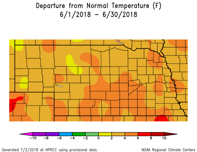
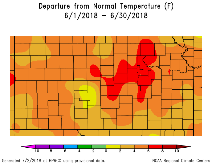
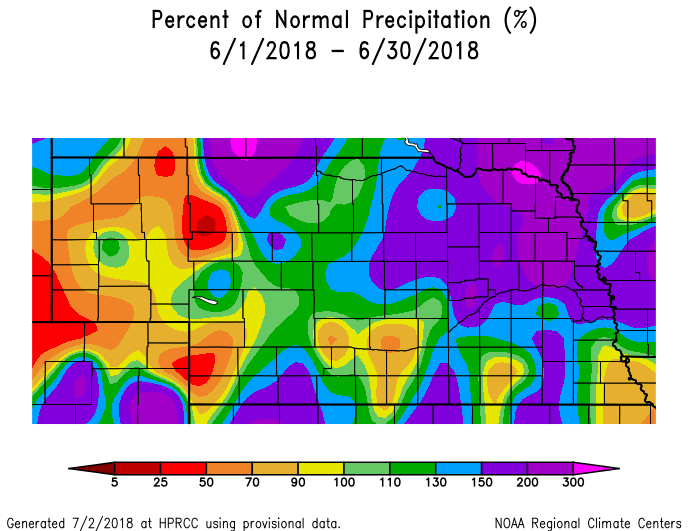
Temperature & Precipitation Departure From Normal Maps:
These images depict June 2018 monthly temperature departure from normal & precipitation percent-of-normal for both Nebraska & Kansas. Images are courtesy of the High Plains Regional Climate Center (HPRCC). Please note: These maps occasionally contain "bullseyes" of errant data. For precipitation, you can also generate departure from normal/percent-of-normal maps using the NWS AHPS page, or view local-area images generated each day by NWS Hastings.
 |
 |
 |
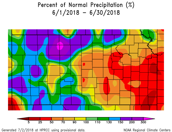 |
| Departure from Normal Temperature - NE (left) & KS (right) | Percent of Normal Precipitation - NE (left) & KS (right) | ||
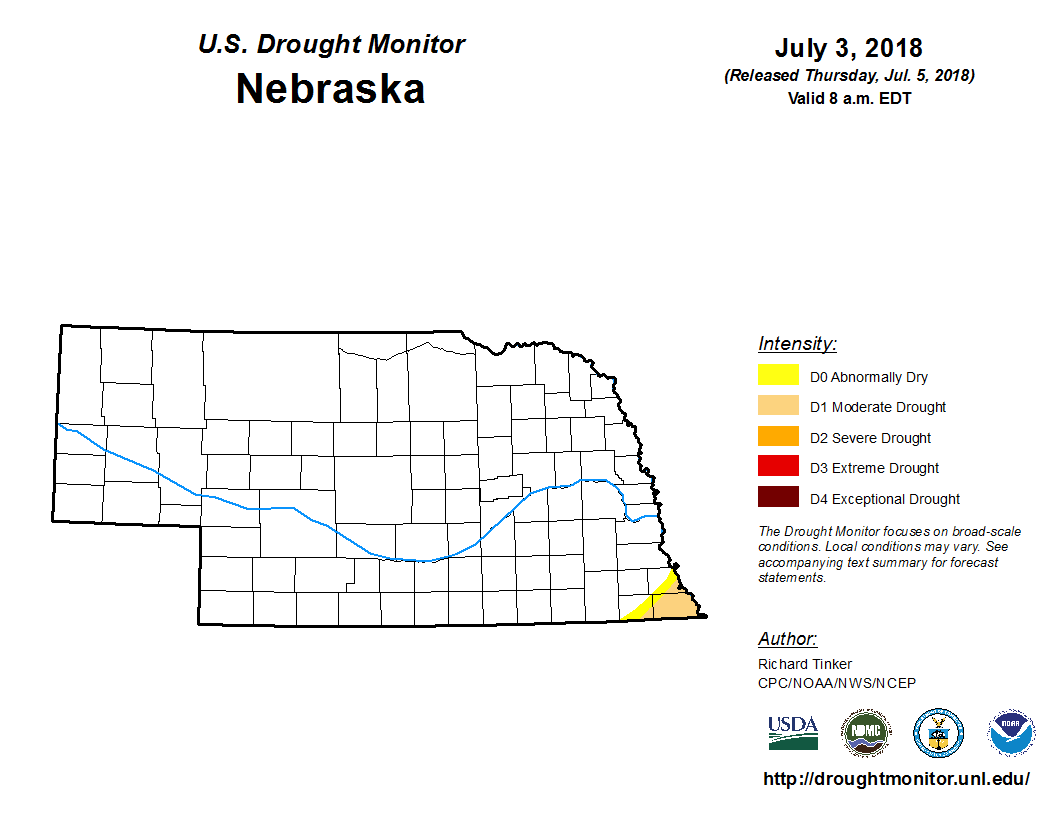
Drought:
The following drought images, current as of July 3, 2018, are courtesy of the U.S. Drought Monitor
Summary of changes during June across the NWS Hastings coverage area:
Following a month that saw at least 80% of the NWS Hastings coverage area receive above normal rainfall (limited areas several inches above normal), the entire 30-county area became void of all drought categories whatsoever by month's end! This marked the first time the entire area was considered "drought free" since mid-June 2017. More specifically, over the course of the month, mainly southern portions of the area (near and south of the state line) saw lingering areas of Abnormally Dry (D0) and Moderate Drought (D1) fade away. Technically speaking, the northern edge of an area of D0 over central KS still brushed up against the far southern border of Osborne County, as drought conditions lingered just south and southeast of the local area in parts of central and especially east-central Kansas.
 |
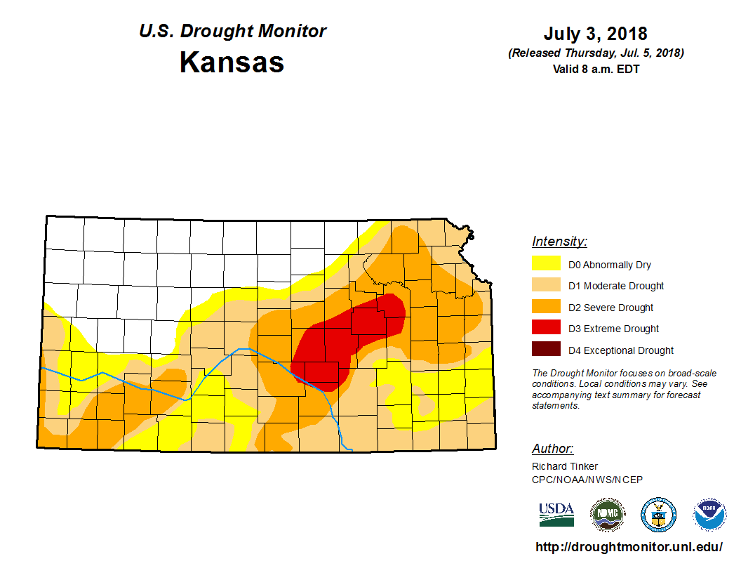 |
| Drought Monitor for Nebraska (left) & Kansas (right). Valid as of July 3, 2018 (click to enlarge) | |
Monthly Extremes for the NWS Hastings Coverage Area:
...A FEW OF THE WARMEST HIGH TEMPERATURES DURING JUNE 2018...
(all data from NWS cooperative observers or automated airport sites, with the date it actually occurred indicated in parentheses)
104 degrees...Smith Center KS (28th)
103 degrees...Beloit KS (28th) - Grand Island airport (15th) - Hebron airport (10th) - Harlan County Lake (15th) - Red Cloud (15th) - Webster Dam (28th) - Kirwin Dam (28th)
102 degrees...Edison (15th) - 6NNW Oxford (15th)
...A FEW OF THE COOLEST LOW TEMPERATURES DURING JUNE 2018...
(all data from NWS cooperative observers or automated airport sites, with the date indicated in parentheses)
45 degrees...Edison (3rd) - Cambridge (3rd) - Beaver City (3rd)
47 degrees...Lexington airport (3rd) - Ord airport (3rd) - Gothenburg (3rd)
48 degrees...Ravenna (3rd) - 6NNW Oxford (3rd) - Red Cloud (3rd)
...A FEW OF THE HIGHEST MONTHLY PRECIPITATION TOTALS DURING JUNE 2018...
(all data from NWS cooperative observers and CoCoRaHS/NeRAIN observers unless indicated)
10.03"...2W Genoa
9.49"...7SSE Ord
9.48"...Belgrade
9.45"...4E Waco
9.23"...7NNE Loup City (near Sherman Reservoir)
...A FEW OF THE LOWEST MONTHLY PRECIPITATION TOTALS DURING JUNE 2018...
(all data from NWS cooperative observers and CoCoRaHS/NeRAIN observers unless indicated)
2.10"...Phillipsburg KS - Kirwin Dam KS
2.58"...6S Wilcox
2.87"...Kearney airport (NWS observer)
2.94"...Logan KS
3.06"...Naponee
 |
Media use of NWS Web News Stories is encouraged! Please acknowledge the NWS as the source of any news information accessed from this site. |
|

