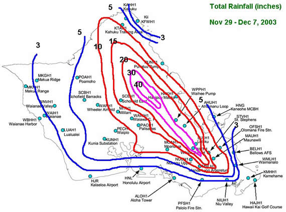
During the last few days of November and the first week of December, several weather systems combined to bring several rounds of heavy rainfall to many parts of the state. Oahu ended up taking the brunt of many of these heavy rainfall episodes and as a result, a few locations in the Koolau Mountains of Oahu likely received over 3 feet of rain in just a 10 day period (click here for map). Here are some rainfall amounts for selected locations across the state:
| Location Amount | (inches) |
|---|---|
| Wilson Tunnel, Oahu | 32.98 |
| Mt Waialeale, Kauai | 27.10 |
| Luluku, Oahu | 26.56 |
| West Wailuaiki, Maui | 22.74 |
| Ahuimanu Loop, Oahu | 22.49 |
| Manoa Lyon Arboretum, Oahu | 20.64 |
| St Stephens, Oahu | 18.64 |
| Schofield East, Oahu | 16.58 |
| Maunawili, Oahu | 13.98 |
| Moanalua, Oahu | 12.78 |
| Hana, Maui | 12.45 |
| Mililani, Oahu | 11.76 |
| Laupahoehoe, Big Island | 11.01 |
| Oheo Gulch, Maui | 10.51 |
| Hanalei, Kauai | 9.99 |
| Waiakea Uka, Big Island | 9.78 |
| Mountain View, Big Island | 9.47 |
| Pahoa, Big Island | 8.30 |
| Punaluu, Oahu | 8.23 |
| Wailua, Kauai | 7.84 |
| Hanalei, Kauai | 7.29 |
| Hilo, Big Island | 6.92 |
| Makapulapai, Molokai | 6.46 |
| Waipio, Oahu | 5.72 |
| Kapapala Ranch, Big Island | 5.63 |
| Lihue, Kauai | 4.77 |
| Honolulu Airport, Oahu | 2.78 |
| Lanai City, Lanai | 2.49 |
| Kahului, Maui | 1.99 |
| Kona/Keahole Airport, Big Island | 0.48 |
A quick look at weather maps and satellite pictures would not reveal anything totally obvious. However a couple of subtle features worked together to produce heavy rainfall mainly along windward and mauka sections of Maui and Oahu. The first was the remnants of an old cold front (called a shear line) that was pushed along in the tradewind flow. Shearlines are fairly common and tend to have increased shower activity in a relatively narrow but long band. As a shearline passes, the tradewinds usually increase in windspeed as well. The blue dashed line in the satellite image below indicates the shear line and zone where the shower activity is increased. The shearline had been moving from east to west in the tradewinds, and at this time (mid-afternoon), the leading edge was along the windward sides of all but Kauai. However, note how the structure of clouds within the shearline differs from north to south. South and east of the Big Island, the clouds have more open areas between them. This is "normal". The clouds are pretty much solid from near Maui and farther north. This is an effect of a more unstable airmass. In fact, a few thunderstorms are occurring northwest of Kauai at this time (upper left corner of the satellite image). This unstable region is due to a developing low pressure system northwest of the state.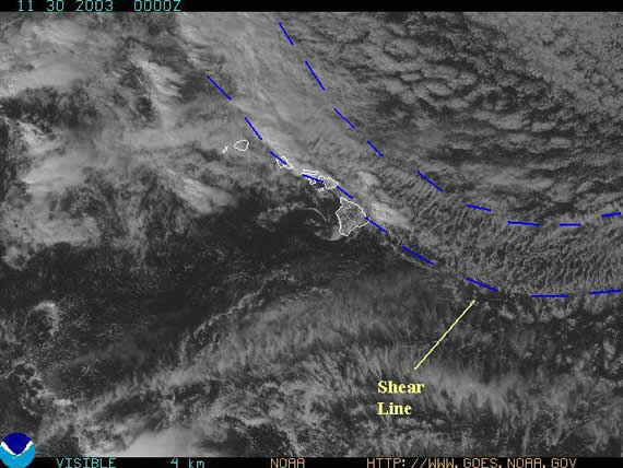
The more unstable airmass allowed the showers with the shearline to become much more widespread and heavier. Another subtle feature was the low level winds were beginning to blow from the southeast versus the normal east-northeast. This was in response to the developing low pressure area. This resulted in the shearline basically stalling over the islands. The last factor at play was "orographic lift" or the concept that as air moves up a mountain, it cools and the moisture condenses into clouds and rain. This happens pretty much every day, and is why tradeshowers are most common over the mountains. However when added together --- orographic lift + unstable air + increased moisture from shearline + stalled shearline that means locally heavy rainfall.
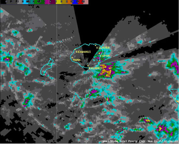
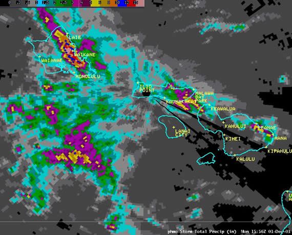
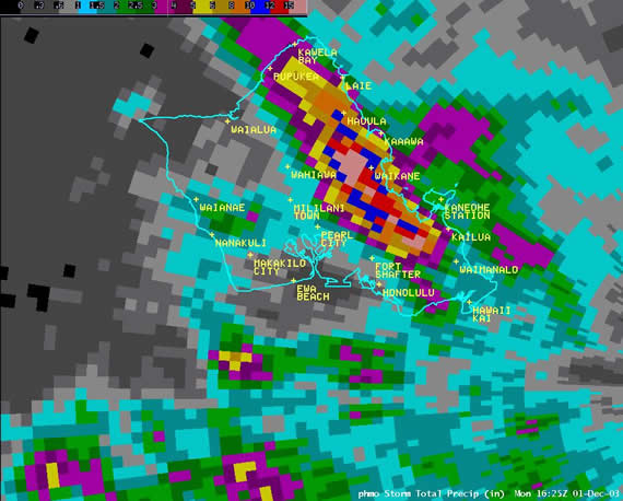
How much rain? Several raingauges on Oahu (Wilson Tunnel, Luluku, Ahuimanu Loop) recorded nearly 13 inches of rain, most of which fell in about 6 hours. The highest total on Maui was from West Wailuaiki of about 10 inches. Several streams came out of their banks and flooded roadways forcing road closures, but no major damage occurred. Below are several images of radar estimated rainfall. A few things to note:
Low pressure continued to develop northwest of the islands. Winds around the islands (green arrows in satellite image below) had shifted to the south in response. They were fairly light and this allowed sea breezes to develop. The shearline had pretty much stalled and nearly dissipated between Kauai and Oahu. The remnants of the shearline did provide a focus for a few showers, mainly over the water, but without all the ingredients coming together in the same way as the a day earlier, rainfall amounts were much less (on the order of 1 to 2 inches) and associated with afternoon interior showers due to sea breeze convergence.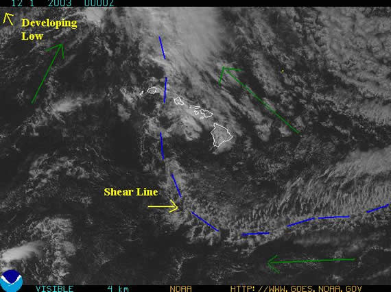
During the day, that low pressure that had been developing moved by to our north and helped push a cold front through Kauai, Oahu and into Maui. Ahead of this cold front, numerous showers and thunderstorms developed and moved across those islands. They brought briefly heavy rainfall, but since the showers and storms did not linger in any location for an extended period, final rainfall totals were not as high as two days earlier. In fact, rainfall amounts were much more consistent across the islands as the mountains did not have a strong effect in "capturing the rain". There was one except to this. With the winds primarily from the west-southwest ahead of the front, the island of Lanai helped produce a narrow "plume" downwind of the island of enhanced shower activity. This in turn resulted in some locally heavy rains around Olowalu, Maui with radar estimating near 10 inches. Unfortunately, no rainguages are there to confirm actual rainfall amounts, although roads were reported flooded in the area.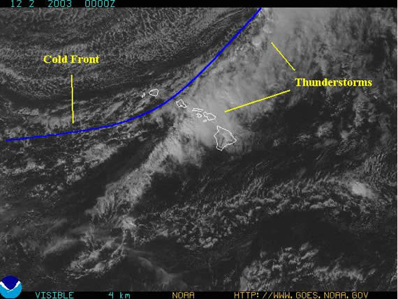
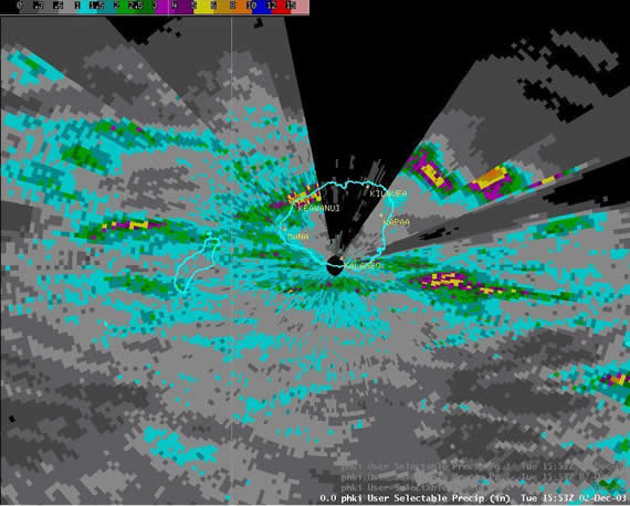
The low pressure was now well northeast of the state, but the cold front's progress was much slower. In fact, the front was in the process of dissipating across the Big Island. Still, this resulted in some locally heavy rains to fall across the Kohala area during the morning. During the afternoon, with the nearly dissipated cold front laying across the southern part of the island, it in combination with daytime heating acted as a focus for the development of thunderstorms in the Pahala and Volcano National Park Area. These thunderstorms produced locally heavy rainfall and even some small hail. On the peaks of Mauna Loa and Mauna Kea, the first snows of the winter occurred. Accumulation was light however.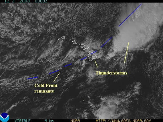
Radar estimated rainfall. Note that many of the blank areas are due to beam blockage caused by Mauna Loa and Mauna Kea.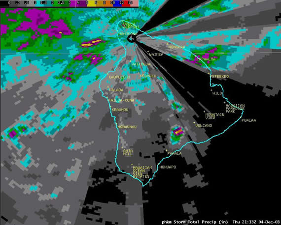
Tradewinds were dominant through the period, however the were "wetter" than normal. There was a weak trough of low pressure in the upper atmosphere which resulted in slightly more unstable conditions than normal. In addition, several batches of moisture (shower areas), including the remnants of the front which had dissipated over the Big Island, were embedded in the tradewind flow. The combination of the moisture and slightly unstable airmass led to some locally heavy rainfall amounts mainly over windward and mauka areas. This was due more to repeated brief but heavy showers over the course of several days rather than long lasting rain events. By December 6, the tradewinds had weakened sufficiently to allow sea breezes to develop resulting in afternoon showers over interior areas of the islands.
Below is a satellite image from December 5. Note the numerous areas of clouds and showers around the islands.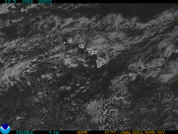
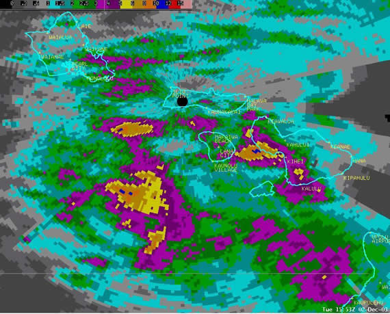
The upper level trough of low pressure to the west of the islands strengthened, resulting in much more unstable conditions over the western half of the state. With the tradewinds fairly weak, daytime sea breezes once again developed. In the unstable airmass, heavy showers and thunderstorms developed over interior portions of mainly Oahu during the afternoon. Then late in the day, tradewinds began to strengthen and much like the case on November 29, the favored area for heavy rains became the Koolau Mountains. In this case however, the atmosphere was more unstable so a thunderstorm lasting for nearly 6 hours was the result. Prevailing winds were also from the east rather than southeast, so the rain that formed over the Koolaus drifted west and over much of Honolulu and west Oahu resulting in significant urban flooding.
Satellite Image from 2pm. Note the small thunderstorm directly over Oahu. Additional clusters of thunderstorms are found north of Oahu and west of Kauai.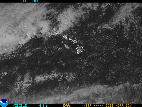
Satellite image from 8pm. Note the brighter white clouds. Those are the thunderstorms. There is still one over Oahu and another one between Kauai and Oahu. Additional thunderstorms are embedded in the mass of clouds west of Kauai.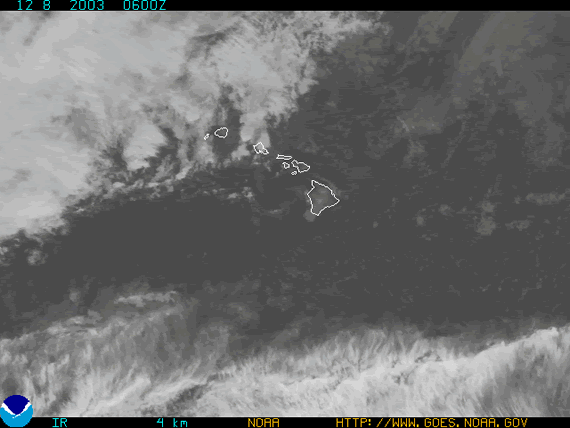
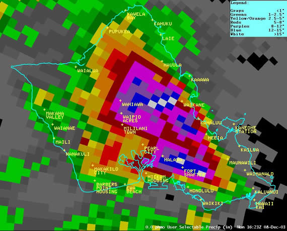
Below are two images of rainfall estimates. The first from the radar on Kauai. Note how most of the heavy rains occurred west of Kauai and over and around Oahu. The second rainfall estimate for Oahu is from the radar on Molokai. The estimated values are different between the radars because of sampling differences due to the different distances the radars were from the thunderstorms. Lastly note how the rainfall pattern on Oahu for this day differs from November 29, yet similar with respect to how the heaviest rain amounts move downwind with the prevailing wind direction.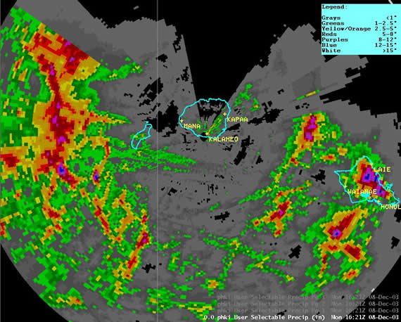

