August 2020 Climate Summary and Highlights
|
Summary Overall, August 2020 was drier and cooler than normal across the region. Below are August climate highlights for Wichita, Salina, Wichita had an average monthly temperature of 78.6 degrees, which was 1.4 degrees cooler than normal. It tied for the 52nd coolest August since official records began in 1888, and it was the coolest since 2017. The city hit 100 degrees only one day during the month, which is below the normal of about 4 to 5 days. Precipitation-wise, only 1.05 inches was measured at Eisenhower National Airport, which was 2.66 inches drier than normal. It was the 20th driest august on record, and the driest since 2000. Salina had an average monthly temperature of 77.5 degrees, which was 2.1 degrees cooler than normal. It tied for the 36th coolest Chanute had an average monthly temperature of 78.5 degrees, which was 0.4 degrees cooler than normal. It tied for the 49th coolest August since official records began in 1896, and it was the coolest since 2018. The city hit 100 degrees one day during the |
August Temperatures
| Monthly Average Temperature | Average Temperature Departure from Normal |
 |
 |
| August 2020 average temperatures across Kansas (the average of each daily high and low temperature). | August 2020 average temperature departure from normal across Kansas. Monthly temperatures were below normal across portions of central, southern, and eastern Kansas, with mostly above normal temperatures across west and northwest Kansas. |
| Kansas August Temperature Rankings by Division |
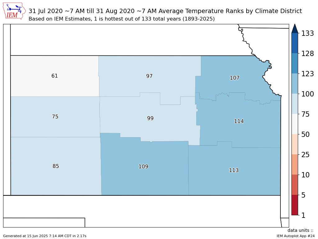 |
| Kansas August 2020 temperature rankings by division. One denotes the warmest August on record (since 1893), 128 denotes the coolest. Much of the eastern two-thirds of the state was cooler than normal, while western portions were generally near normal. |
August Precipitation
| Monthly Precipitation | Precipitation Departure from Normal |
 |
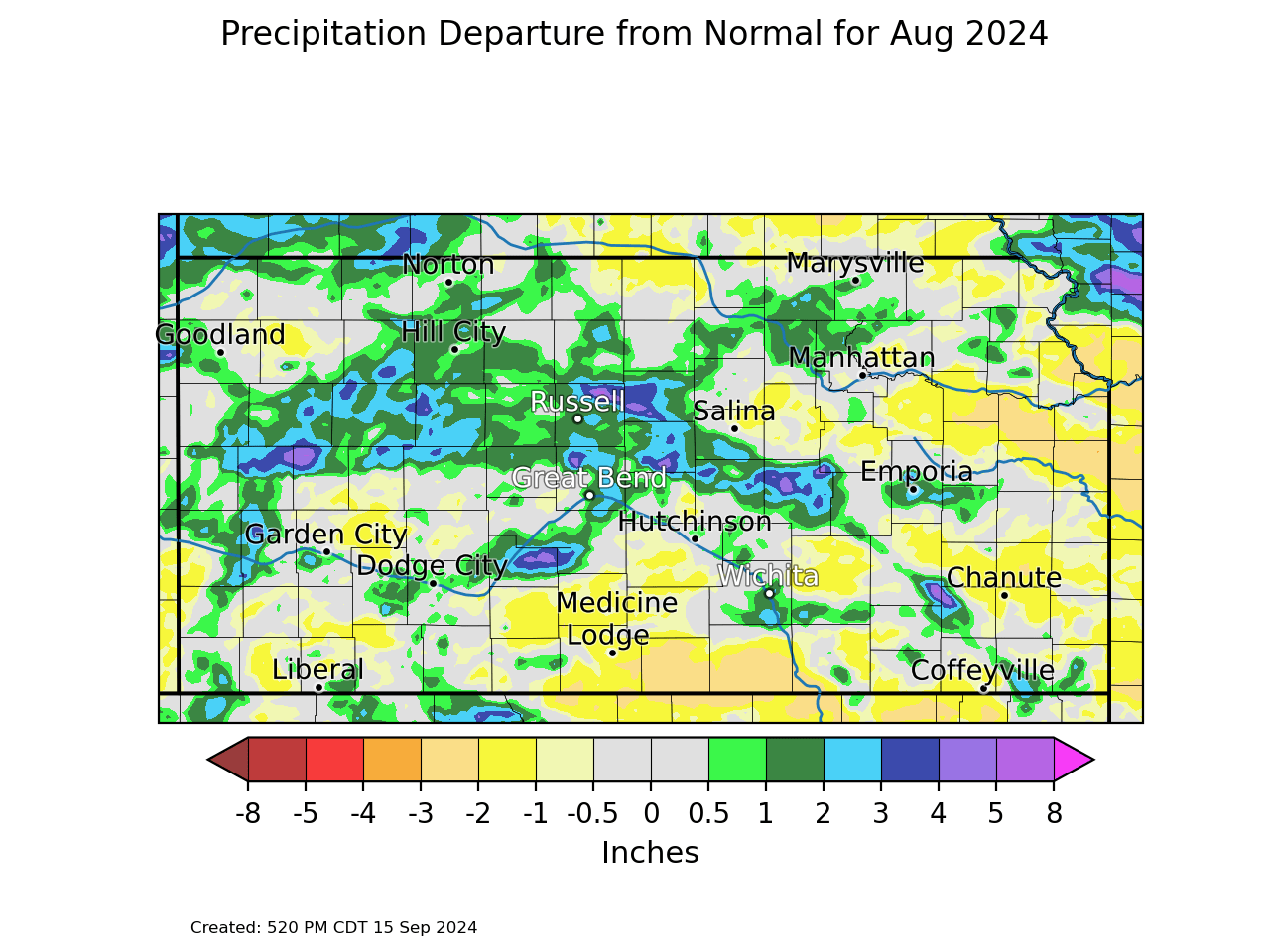 |
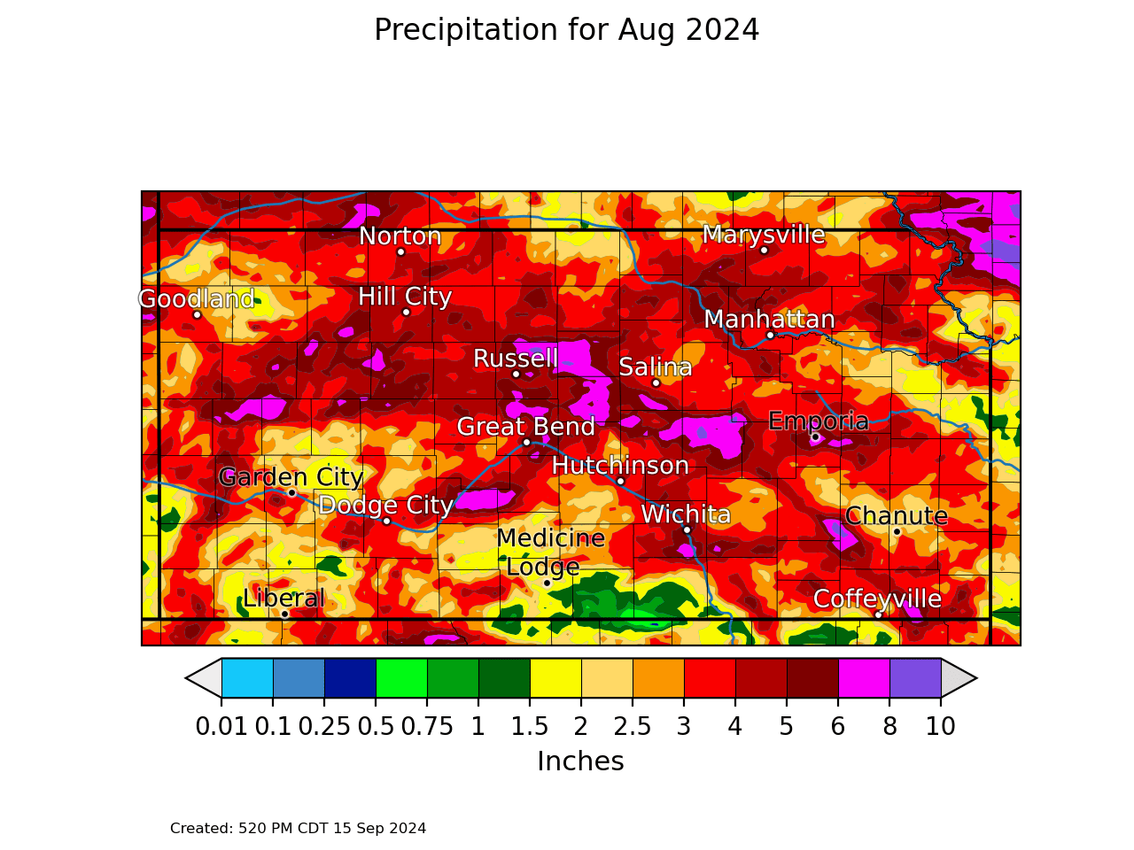
| August 2020 precipitation across Kansas. | August 2020 precipitation departure from normal across Kansas. With the exception of portions of west-central Kansas, much of the state saw below normal precipitation. |
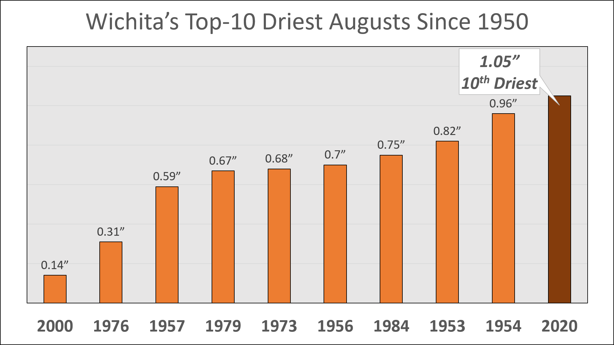
| Wichita's Top-10 Driest Augusts Since 1950 | Salina's Top-15 Driest Augusts Since 1900 |
 |
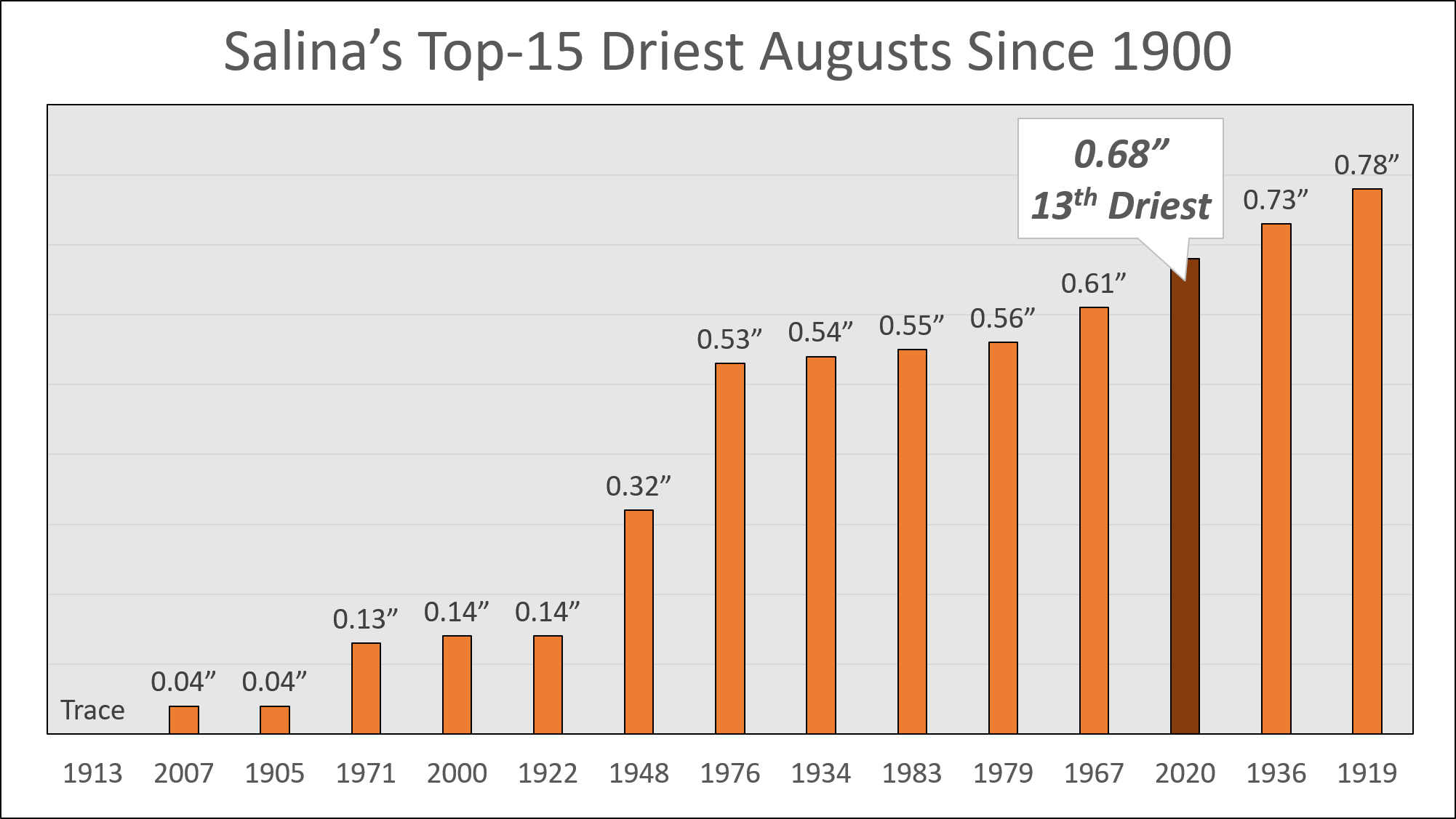 |
| Wichita's 1.05 inches of rainfall in August was 2.66 inches below normal, and the driest August since 2000. | Salina's 0.68 inches of rainfall in August was 3.27 inches below normal, and the driest August since 2007. |
|
Kansas August Precipitation Rankings by Division |
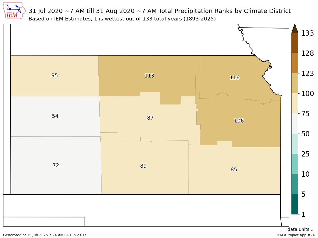 |
| Kansas August 2020 precipitation rankings by division. One denotes the wettest August on record (since 1893), 128 denotes the driest. Much of the state saw a drier than normal August, especially northeast portions. |
Miscellaneous Climate Information
| Mean Jet Stream Location | 500mb Height Anomaly |
 |
 |
| For August, the jet stream was generally located across the northern U.S., but it did dip south into the Plains some. | August featured upper level ridging over the western U.S. and upper level troughing over the Southeastern U.S. The upper level trough likely helped keep temperatures a bit cooler over eastern Kansas. |
| Moisture Anomaly | August Severe Thunderstorm Warnings |
 |
 |
| Moisture available for precipitation was noticeably lower than normal across much of the Plains, which likely factored into the drier conditions for much of Kansas. | The above map shows the number of Severe Thunderstorm Warnings issued for each county in Kansas. The most active area was western Kansas, while eastern Kansas was fairly quiet. |
 |
Media use of NWS Web News Stories is encouraged! Please acknowledge the NWS as the source of any news information accessed from this site. |
|

