Central and Southeast Kansas 2016 Annual Summary
Chance Hayes - Warning Coordination Meteorologist
I have heard many people say that 2016 was not a very busy year in regards to hazardous weather. In all actuality, Central and Southeast Kansas experienced normal to slightly above normal hazardous weather this past year, especially with regard to thunderstorms and their associated hazards.
The winter season did not pack much of a punch, with only a few relatively minor winter weather scenarios. In fact, Wichita’s greatest snowfall of 3.5 inches occurred early Easter morning, but most of this melted by afternoon. However, once the spring storm season rolled in, several outbreaks occurred, two of which were highlighted by EF-3 (136-165 mph) tornadoes and a few rounds of significant flash flooding. Unfortunately, one person died this past year due to the flash flooding. This continues to amplify the importance of understanding flood safety, which includes staying away from flooded creeks, streams, or rivers.
For the 26 counties served by NWS Wichita, 18 tornadoes were reported, which is near the 1950-2016 average of 18.9 tornadoes. However, we were below the most recent ten and five year averages of 26.7 and 20.6 tornadoes, respectively. The first tornado of the year occurred on March 30th, and the last was on October 6th.
 |
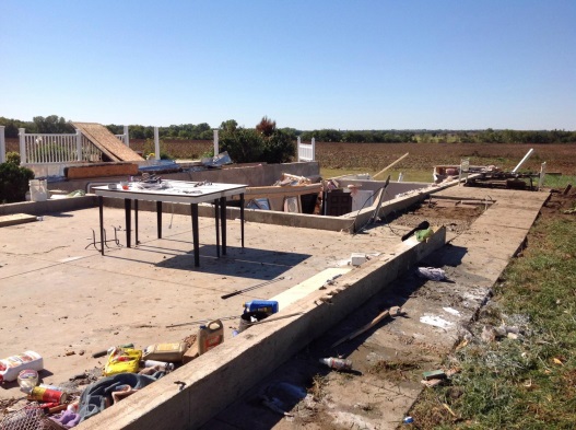 |
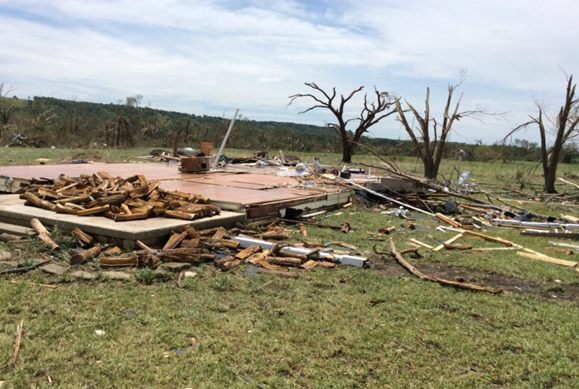
| EF-3 tornado damage northwest of Eureka on July 7th. Click image to enlarge. | EF-3 tornado damage in eastern Saline county on October 6th. Click image to enlarge. |
For the two tornadoes on July 7th in Greenwood County, a total of 152 structures were damaged or destroyed. Of those structures, 31 homes were destroyed, 23 homes had major damage, 32 homes had minor damage and 4 mobile homes were destroyed. Preliminary damage estimates totaled $3.8 million. The most important and impressive aspect to this situation was that there were zero injuries and zero fatalities. Much of this can be attributed to the preparedness efforts of Greenwood County officials and Wireless Emergency Alerts. Interestingly, the EF3 that occurred well northwest of Eureka was only the 5th EF-3 or stronger tornado during the month of July across Kansas since records began in 1950. (Courtesy of the Storm Prediction Center and National Center for Environmental Information).
The second tornado outbreak was also during a “non-tornado” time frame of October. A total of 7 tornadoes touched down on the 6th, one of which was rated EF-3 in Saline County. This tornado moved NNE for approximately 6.5 miles, remaining over rural areas. However, about 12 homes found themselves to be in the cross hairs, with two taking direct hits. A manufactured double wide home which was held down by straps was completely lifted and destroyed. Additionally, a jeep was rolled approximately 200 yards. There was damage to other farm equipment which was tossed from their original locations. Another homestead received significant tree and outbuilding damage along the tornado’s path. All farm machinery were thrown across the property. Of significance was a combine that was rolled about 75 yards.
 |
 |
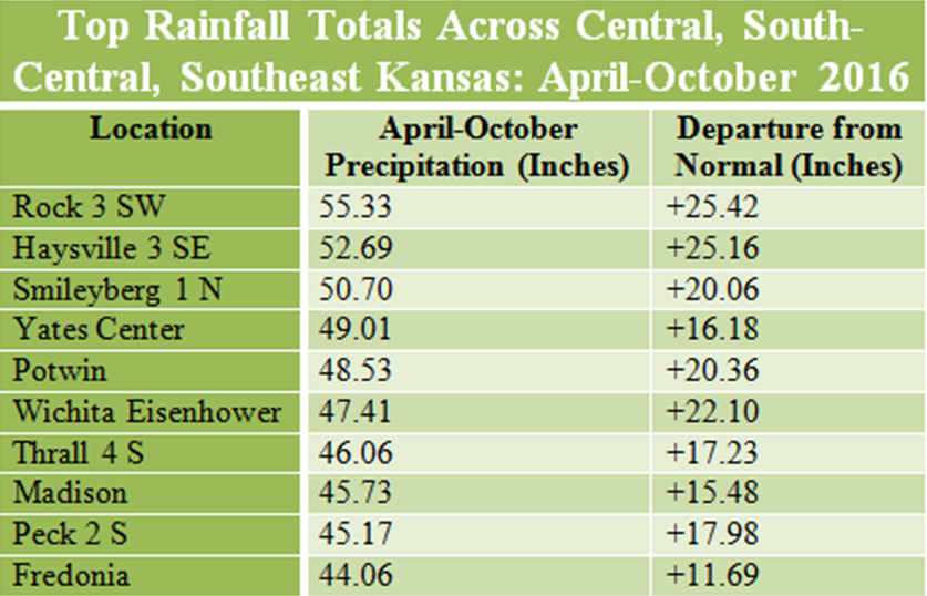
| A handful of sites across South-Central and Southeast Kansas were 10 to 25 inches above normal from April through October. Click image to enlarge. | April through October Departure from normal rainfall across Kansas. Notice the bullseye in and around the Wichita Area. Click image to enlarge. |
Before we look at the significant flooding, we wanted to let you know that our office issued a total of 337 severe thunderstorm warnings in 2016, with a combined 486 reports of hail one inch or larger and winds greater than 58 mph. The 337 warnings and the 486 reports of severe weather were the second highest total across NWS Wichita’s area of responsibility since 2010.
When we begin to look at rainfall, many locations reported above normal precipitation since spring. In fact, numerous areas are at least four to eight inches wetter than normal since April, with a large handful of sites greater than eight to twelve inches above normal. The wettest areas have been over generally the southeast quarter of Kansas, with a handful of sites twenty to twenty-five inches wetter than normal since April, especially within about a 50 mile radius of Wichita. Two months were ranked in or near the top-ten wettest across the Sunflower State since records began in the 1890s, including April (2nd wettest) and August (11th wettest). Oddly, three months tallied below normal precipitation statewide: March, June and October. Wichita experienced it’s 2nd wettest January through October period on record (since 1889), tallying a staggering 49.68 inches at Eisenhower National Airport.
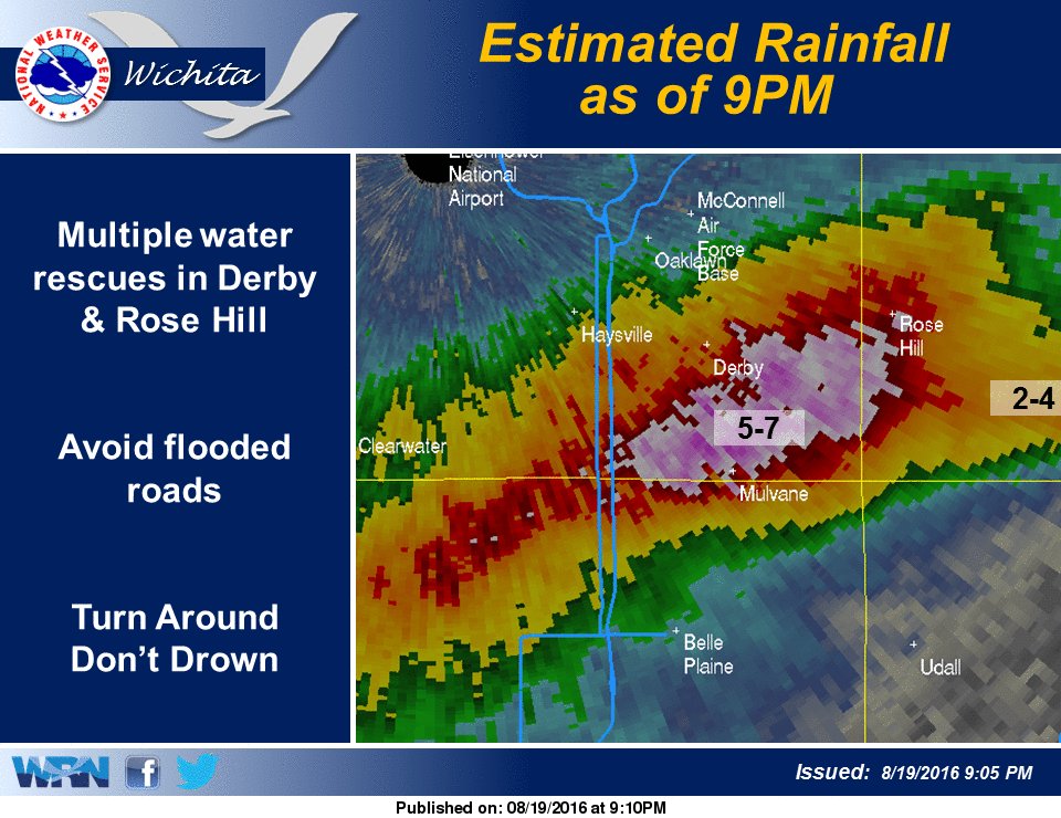 |
| Extremely heavy rainfall occurred on the evening of August 19th, especially just south of the Wichita Metro, including Mulvane, Derby and Rose Hill. Most of this rain fell within a 2-3 hour time frame. Significant flash flooding occurred, with numerous water rescues and home evacuations. Click image to enlarge. |
For residents of Central and South-Central Kansas, the July 4th holiday weekend literally started with a ‘bang’ as numerous severe thunderstorms put on a fireworks show of their own. On the 2nd and 3rd, the nasty convection unleashed torrential rains that were so intense that people couldn’t help but wonder if they were driving through a car wash. Hardest hit were Reno, Sedgwick and Butler counties, where 4 to 8 inches inundated many areas. Parts of Wichita were swamped by 9 inches. The 5.72 inches measured on the 2nd at Eisenhower Airport not only washed out the calendar day record of 2.04 inches measured in 1989 by a staggering 3.68 inches, it was the 6th greatest 1-day rainfall of all time.
Wichita wasn’t the only location to be inundated with water during this time frame. In Reno and Rice Counties, the Cow Creek experienced flooding. In fact, Rice County remained under a flood warning for a week.
August flooding inundated much of Southern Kansas. With a very moist atmosphere in place, these storms produced rainfall rates around 2-3 inches per hour. Several rounds of storms affected Southern Sedgwick and Southern Butler counties which resulted in rainfall in the 5 to 7 inch range, with most of it falling in around 2 hours. This rapid amount of rain accumulation led to significant flash flooding, especially near the communities of Mulvane and south of Rose Hill. Numerous water rescues took place with homes also evacuated.
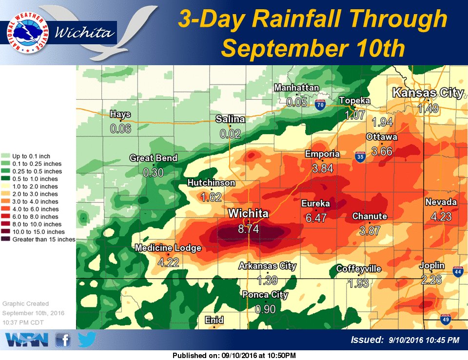 |
| Multiple rounds of very heavy rain inundated the southeast quarter of Kansas in early September. Much of the rainfall came in relatively short periods, with rainfall rates at times exceeding 3 inches per hour. Several water rescues were performed. Click image to enlarge. |
In early September, rainfall amounts proved extreme, with widespread 3 to 6 inch amounts across much of the southeast quarter of Kansas. Localized amounts even exceeded 8 to 10 inches. Much of the rainfall came in relatively short periods, with rainfall rates at times exceeding 3 inches per hour. This was the second round of flooding for many locations that had just recovered from the previous event in August. Several water rescues were performed.
So, as we reflect on this past year, one can see that it wasn’t quite as calm as people may believe. With so much hazardous weather and so few injuries and the one fatality, it shows the importance of severe weather safety any time of the year.

