 |
 |
 |
|
|
|
|
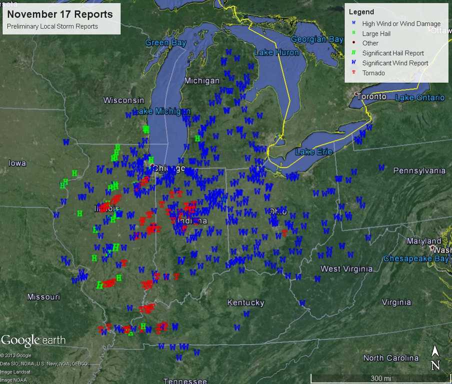
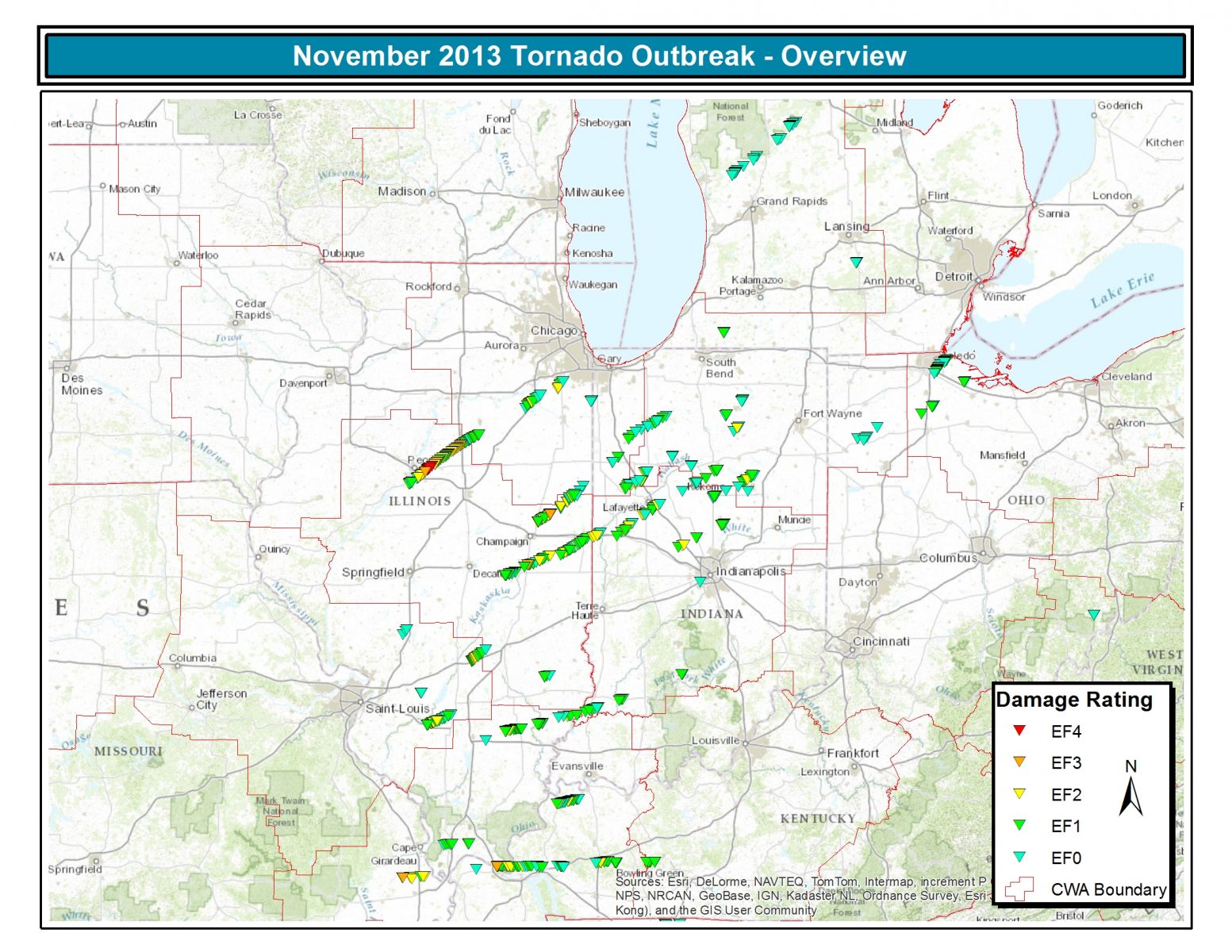
A major late-season severe weather outbreak occurred across the Midwest on Sunday, November 17, 2013. Many tornadoes were reported, especially across Illinois and Indiana, and wind damage occurred from the Mississippi River eastward as far as New Jersey and New York City.
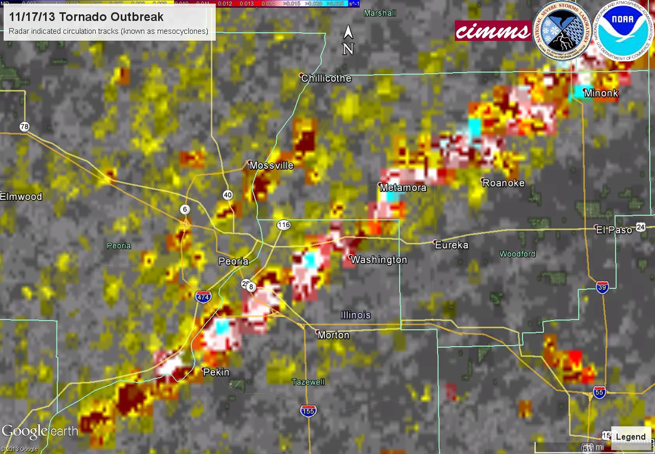
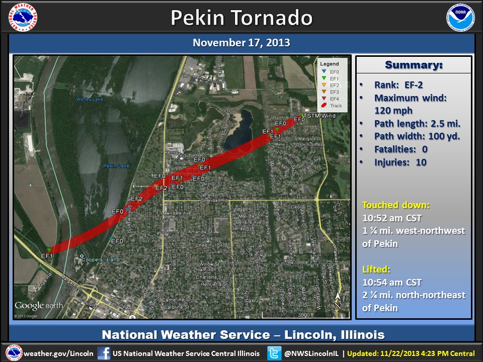
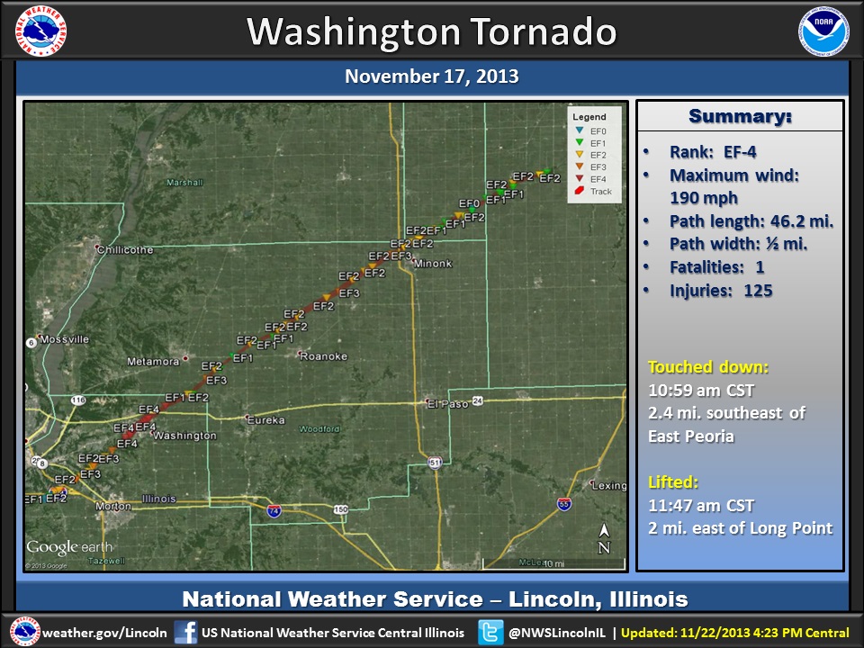
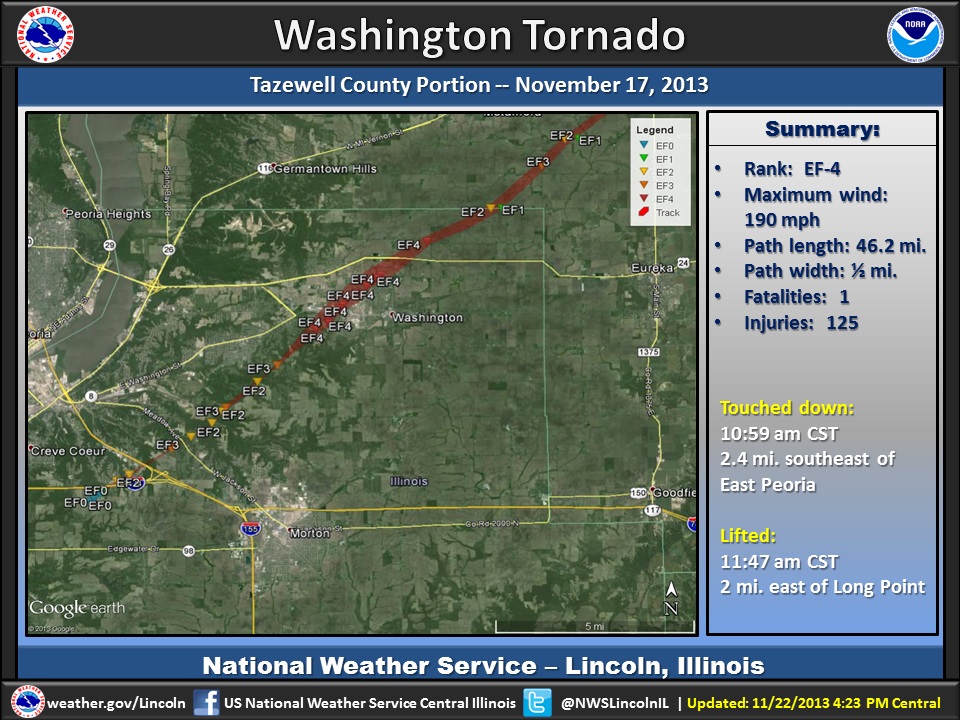
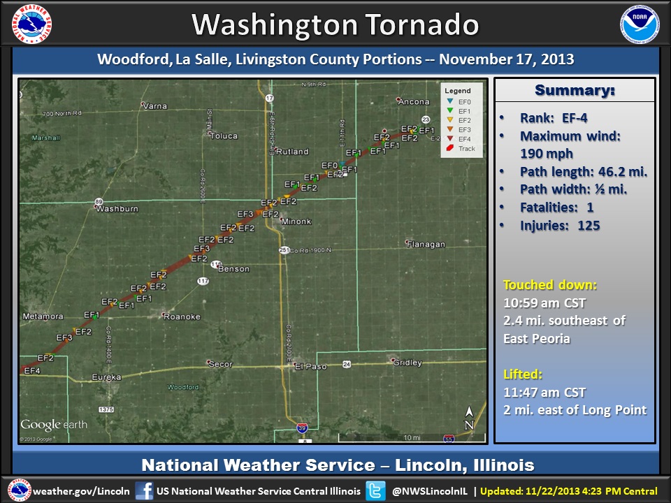
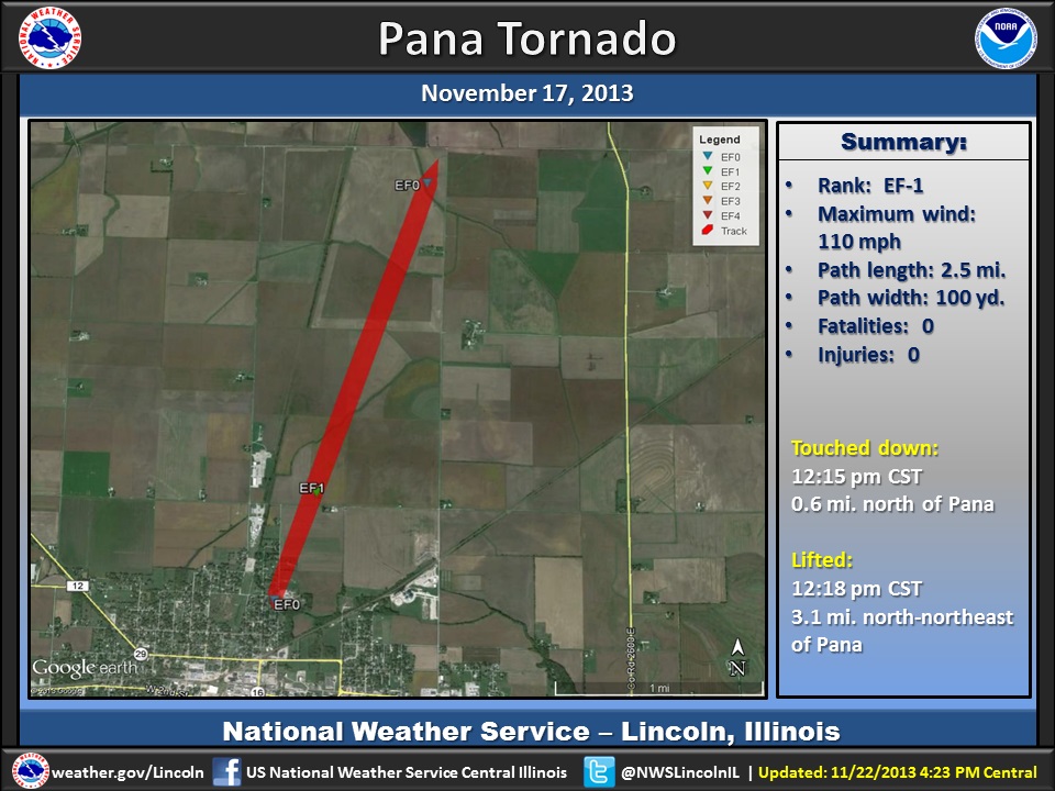
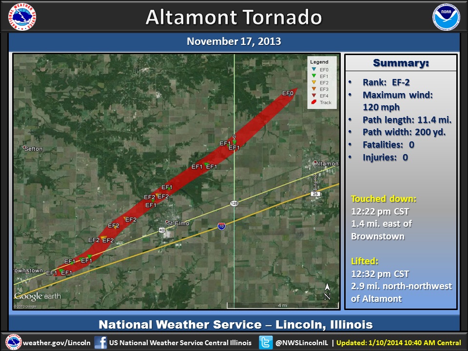
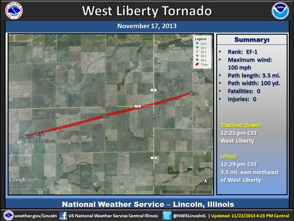
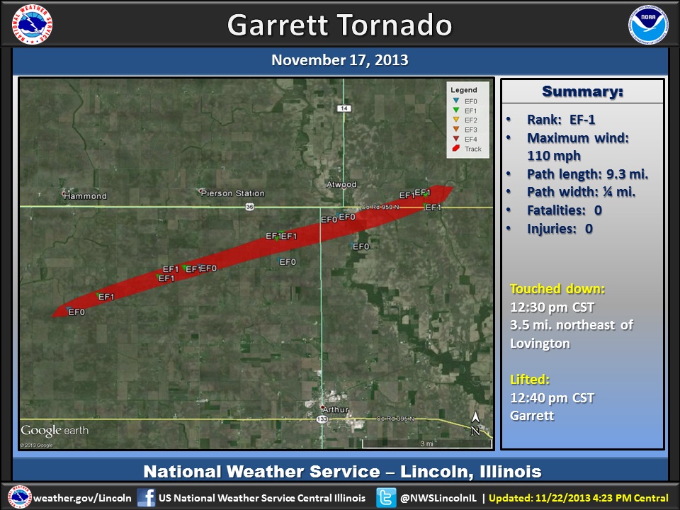
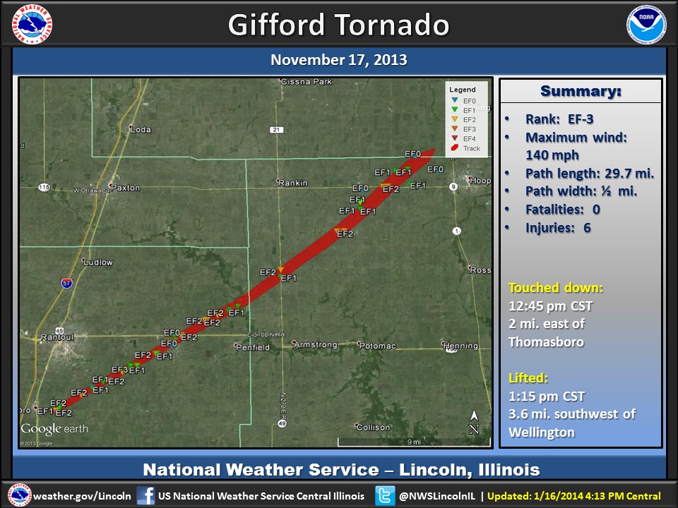
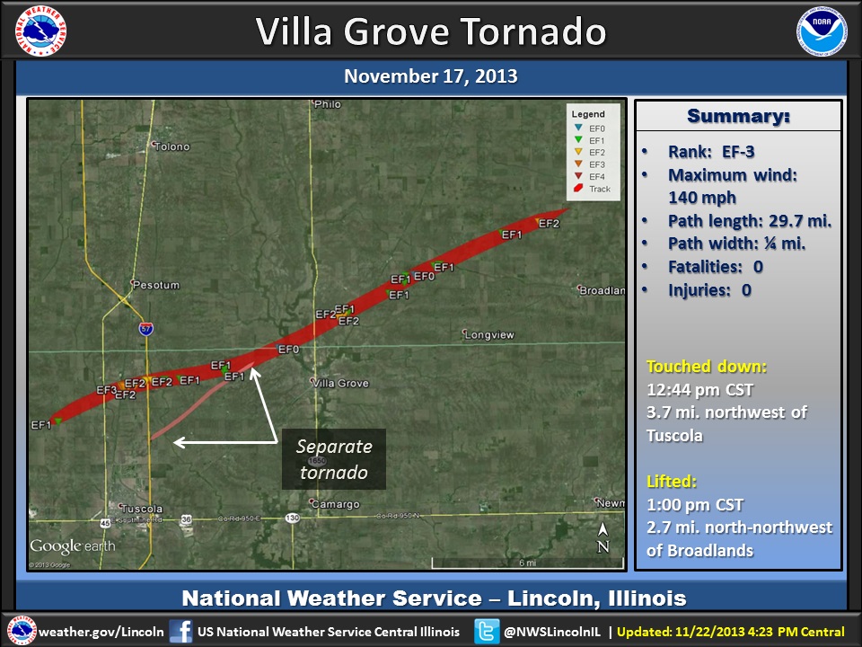
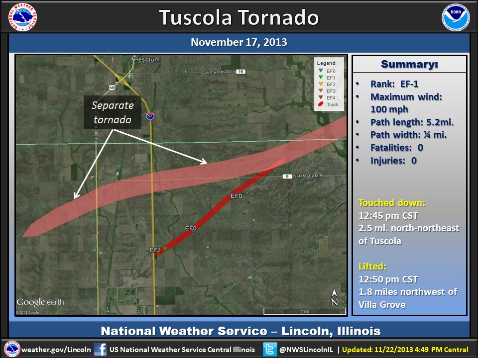
In central Illinois, survey teams evaluated 10 tornado tracks. Survey assistance was provided by the NWS offices in Chicago and St. Louis. Here are the maps for each track (click to enlarge):
A larger scale mapping all of the tracks is below (click image to enlarge).
Summary Table:
Here is a summary of tornadoes in central, eastern and southeast Illinois:
| Location | Intensity and Peak Wind | Path Length | Fatalities | Injuries |
| Pekin (Peoria and Tazewell Counties) | EF-2 (120 mph) | 2.5 miles | 0 | 10 |
| Washington (Tazewell and Woodford Counties) | EF-4 (190 mph) | 46.2 miles | 3 | 125 |
| Pana (Christian County) | EF-1 (110 mph) | 2.5 miles | 0 | 0 |
| Altamont (Fayette and Effingham Counties) | EF-2 (120 mph) | 11.4 miles | 0 | 0 |
| West Liberty (Jasper County) | EF-1 (100 mph) | 3.5 miles | 0 | 0 |
| Garrett (Moultrie and Douglas Counties) | EF-1 (110 mph) | 9.3 miles | 0 | 0 |
| Gifford (Champaign and Vermilion Counties) | EF-3 (140 mph) | 29.7 miles | 0 | 6 |
| Villa Grove (Douglas and Champaign Counties) | EF-3 (140 mph) | 18.0 miles | 0 | 0 |
| Tuscola (Douglas County) | EF-1 (100 mph) | 5.2 miles | 0 | 0 |
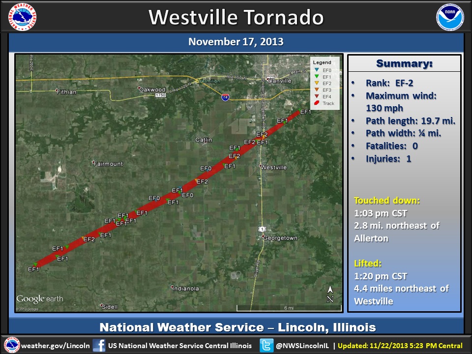
| Westville (Vermilion County) | EF-2 (130 mph) | 19.7 miles | 0 | 1 |
Reports collected by the Storm Prediction Center are found at:
http://www.spc.noaa.gov/exper/reports/?date=20131117&all#
Here is a link to radar loops - on the Chicago NWS office website of the Washington, IL tornado.
https://www.weather.gov/lot/17Nov2013#radar
Information from other nearby areas is available at the following links:
While severe thunderstorms are extremely complex, the ingredients they need to develop come down to a few simple ones: 1.) warmth and moisture, which create instability 2.) strong turning winds with height, creating wind shear and 3.) a focus such as a cold front. The stronger these parameters are, especially wind shear, the greater potential for tornadoes.
In November, the environmental winds tend to be much stronger than in summer or even spring months. This leads to even greater wind shear. Normally though in late autumn and into winter, we do not have sufficient warmth and moisture for thunderstorm development. A powerful low pressure system across the plains states had steered warmth and moisture northward for nearly two days, with moisture similar to summertime values (dew points in the mid 60s). Given temperatures of around 70°, there was more than enough instability to get thunderstorms to go. And this instability was actually off the charts for November. Combine that with the high wind shear, and a cold front sweeping eastward, and you had all the ingredients you needed for thunderstorms, particularly supercells capable of tornadoes. With the parameters all extremely high for any time of the year, long-lived significant tornadoes became likely.
 |
|
|
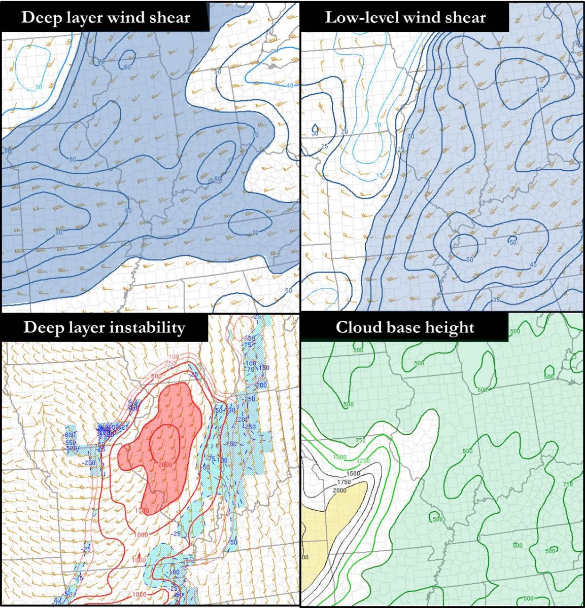
The image at left shows the surface observations across the Midwest on November 17. The colored shades represent the dew point temperatures. The dark green and blue shades represent dew points in the 60s, while the orange and red shades represent dew points in the 40s and 30s respectively. In the right image, going clockwise from top left: deep layer wind shear, low level wind shear, cloud base heights, and deep layer instability. Click images to enlarge. |
|
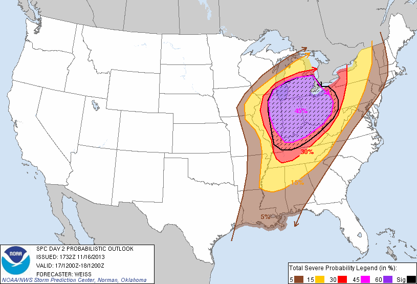 |
The potential for severe weather was detected several days in advance. As early as Thursday morning, November 14, most of central and southeast Illinois was included in the severe weather outloook for Sunday. At that range, areas are highlighted if there is at least a 30% chance of receiving severe weather. The outlook from late Saturday morning, shown at left, indicates a 45% chance of severe weather over much of the Midwest, and a 10% chance of seeing significant severe weather (defined as either tornadoes of at least EF-2 strength, winds of 75 mph, hail of at least 2" in diameter, or any combination thereof) with 25 miles of any given point. |
|
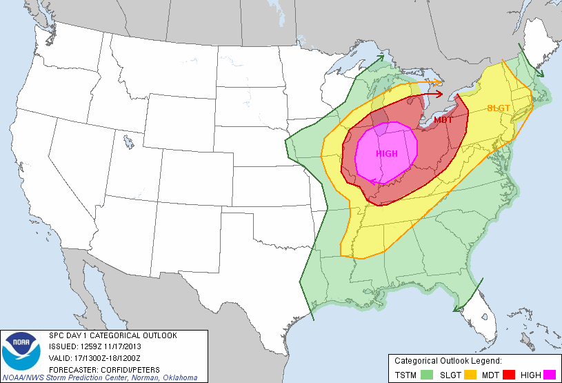
Around midnight Sunday morning, the outlook from the Storm Prediction Center highlighted eastern Illinois as being in a "high risk" of severe weather, and by the 7 am update, expanded it further west to near I-55. The graphic at left shows the tornado probability map for Sunday, from the 7 am update. The purple shades indicate at least a 30% chance of tornadoes, with a 15% chance in red. The hatched areas again indicate there is a least a 10% chance of tornadoes of at least EF-2 strength. |
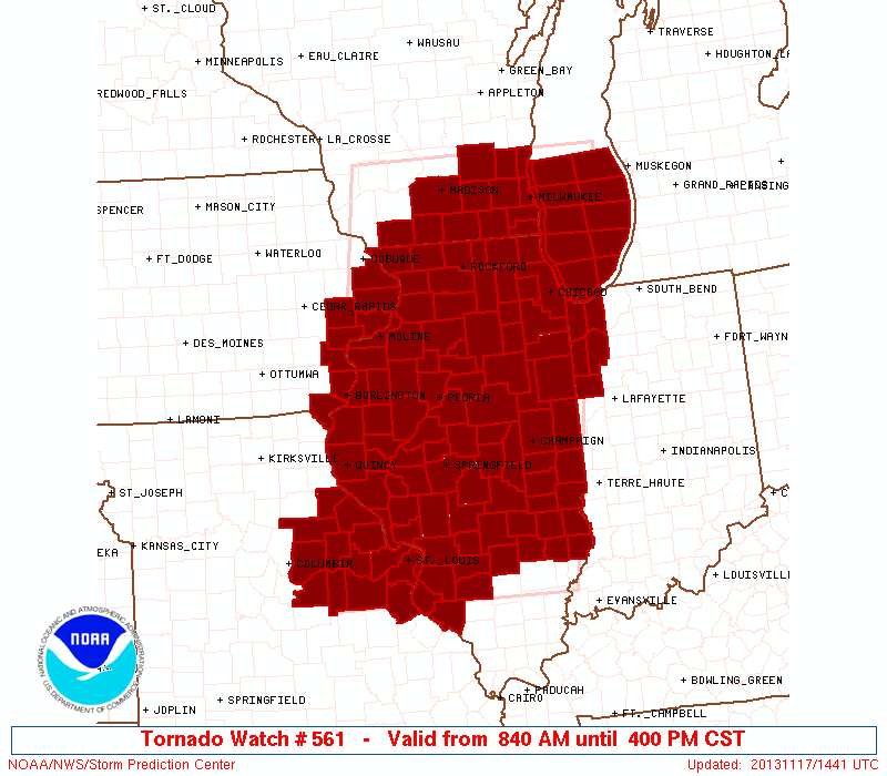 |
At 8:40 am, Tornado Watch #561 was issued for most of Illinois. SPC declared this as a "Particularly Dangerous Situation" (PDS) watch, meaning there was a threat for several intense, long-track tornadoes, potential for many reports of large hail over 2 inches in diameter, and damaging wind gusts potentially in excess of 80 mph. The NWS offices in Lincoln, Chicago, Milwaukee, Davenport, and St. Louis participated in a conference call with SPC around 8:30 am to discuss the issuance of this watch. |
Additional Reports: Wind and Hail
..TIME... ...EVENT... ...CITY LOCATION... ...LAT.LON...
..DATE... ....MAG.... ..COUNTY LOCATION..ST.. ...SOURCE....
..REMARKS..
1015 AM TSTM WND GST JACKSONVILLE 39.73N 90.23W
11/17/2013 M52.00 MPH MORGAN IL AWOS
1025 AM HAIL 2 S PRINCEVILLE 40.90N 89.76W
11/17/2013 M0.88 INCH PEORIA IL EMERGENCY MNGR
1045 AM TSTM WND GST PEORIA INTERNATIONAL AI 40.67N 89.68W
11/17/2013 M70.00 MPH PEORIA IL ASOS
1059 AM TSTM WND GST 3 SW PEORIA 40.71N 89.65W
11/17/2013 M58.00 MPH PEORIA IL ASOS
1101 AM TSTM WND GST 2 W HOPEDALE 40.42N 89.46W
11/17/2013 M56.00 MPH TAZEWELL IL MESONET
IDOT STATION ON I-155 WEST OF HOPEDALE
1109 AM HAIL 2 S PHILADELPHIA 39.89N 90.12W
11/17/2013 M0.88 INCH CASS IL MESONET
1110 AM TSTM WND DMG HENRY 41.11N 89.36W
11/17/2013 MARSHALL IL EMERGENCY MNGR
ONE TREE UPROOTED AND TEN INCH DIAMETER PINE TREE SNAPPED
OFF AND BLOWN AGAINST A HOUSE. DELAYED REPORT.
1110 AM HAIL 1 W METAMORA 40.79N 89.38W
11/17/2013 M1.00 INCH WOODFORD IL TRAINED SPOTTER
1117 AM TSTM WND DMG HARTSBURG 40.25N 89.44W
11/17/2013 LOGAN IL EMERGENCY MNGR
SEMI BLOWN OVER ON I-155. TIME ESTIMATED.
1122 AM TSTM WND DMG PETERSBURG 40.01N 89.85W
11/17/2013 MENARD IL EMERGENCY MNGR
TREE LIMBS DOWN
1125 AM HAIL 1 N PETERSBURG 40.03N 89.85W
11/17/2013 M1.75 INCH MENARD IL MESONET
1126 AM HAIL PETERSBURG 40.01N 89.85W
11/17/2013 E1.00 INCH MENARD IL TRAINED SPOTTER
1126 AM HAIL MCLEAN 40.32N 89.17W
11/17/2013 M1.00 INCH MCLEAN IL PUBLIC
1128 AM HAIL 2 NW ARMINGTON 40.36N 89.34W
11/17/2013 M1.00 INCH TAZEWELL IL EMERGENCY MNGR
1128 AM TSTM WND GST 2 NW ARMINGTON 40.36N 89.34W
11/17/2013 M70.00 MPH TAZEWELL IL EMERGENCY MNGR
1130 AM TSTM WND DMG GREENVIEW 40.08N 89.74W
11/17/2013 MENARD IL EMERGENCY MNGR
LARGE TREES DOWN ON RT. 29 AND POWERLINES DOWN.
1135 AM TSTM WND GST 3 W GALESBURG 40.95N 90.44W
11/17/2013 M64.00 MPH KNOX IL AWOS
1135 AM TSTM WND GST 2 ENE GALESBURG 40.96N 90.34W
11/17/2013 M65.00 MPH KNOX IL MESONET
IDOT STATION ON I-74 AT RAILROAD CROSSING SOUTH OF US-34
EXIT
1135 AM TSTM WND GST 1 ESE BLOOMINGTON 40.47N 88.96W
11/17/2013 M67.00 MPH MCLEAN IL MESONET
APRS MESONET
1141 AM TSTM WND GST 4 N SPRINGFIELD 39.84N 89.64W
11/17/2013 M62.00 MPH SANGAMON IL ASOS
1150 AM TSTM WND GST MORRISONVILLE 39.42N 89.46W
11/17/2013 M60.00 MPH CHRISTIAN IL CO-OP OBSERVER
1150 AM TSTM WND DMG 1 S TAYLORVILLE 39.51N 89.26W
11/17/2013 CHRISTIAN IL EMERGENCY MNGR
POWER LINES DOWN
1153 AM HAIL 7 E MORRISONVILLE 39.42N 89.33W
11/17/2013 M1.00 INCH CHRISTIAN IL TRAINED SPOTTER
1155 AM TSTM WND GST TAYLORVILLE AIRPORT 39.53N 89.33W
11/17/2013 M69.00 MPH CHRISTIAN IL AWOS
1157 AM HAIL NORMAL 40.52N 89.00W
11/17/2013 M2.75 INCH MCLEAN IL EMERGENCY MNGR
IN WEST NORMAL
1157 AM TSTM WND DMG NORMAL 40.52N 89.00W
11/17/2013 MCLEAN IL PUBLIC
TREE DOWN ON NORTH SIDE OF NORMAL.
1200 PM HAIL 2 SW BLOOMINGTON 40.46N 89.00W
11/17/2013 M4.00 INCH MCLEAN IL PUBLIC
MEASURED 3.75 INCH DIAMETER. LOCATED 1.5 MILES WEST OF
INTERSECTION OF SIX POINTS ROAD AND OAKLAND AVE. REPORT
RECEIVED VIA FACEBOOK.
1203 PM TSTM WND GST 1 N ROSAMOND 39.40N 89.16W
11/17/2013 E70.00 MPH CHRISTIAN IL FIRE DEPT
1208 PM NON-TSTM WND GST 5 E WAYNESVILLE 40.24N 89.03W
11/17/2013 E56.00 MPH DE WITT IL MESONET
APRS MESONET
1213 PM TSTM WND GST BLOOMINGTON AIRPORT 40.48N 88.92W
11/17/2013 M58.00 MPH MCLEAN IL ASOS
1214 PM HAIL ASSUMPTION 39.52N 89.05W
11/17/2013 M2.75 INCH CHRISTIAN IL EMERGENCY MNGR
1215 PM TSTM WND DMG 1 ENE BLOOMINGTON AIRPO 40.48N 88.90W
11/17/2013 MCLEAN IL PUBLIC
LARGE POWER LINES DOWN ALONG TOWANDA BARNES ROAD.
1228 PM TSTM WND DMG SAYBROOK 40.43N 88.53W
11/17/2013 MCLEAN IL TRAINED SPOTTER
SEVERAL TREES UPROOTED. NUMEROUS HOMES WITH SHINGLE
DAMAGE. TIME ESTIMATED.
1230 PM TSTM WND DMG 1 S FINDLAY 39.51N 88.75W
11/17/2013 SHELBY IL TRAINED SPOTTER
SEVERAL POWER POLES SNAPPED OFF.
1231 PM NON-TSTM WND GST 1 W HAVANA 40.30N 90.08W
11/17/2013 M59.00 MPH FULTON IL MESONET
IDOT STATION US-136 AT LACY DITCH
1240 PM TSTM WND GST SEYMOUR 40.10N 88.42W
11/17/2013 E70.00 MPH CHAMPAIGN IL EMERGENCY MNGR
1245 PM TSTM WND DMG GALTON 39.74N 88.30W
11/17/2013 DOUGLAS IL EMERGENCY MNGR
GRAIN ELEVATOR DAMAGED
1248 PM TSTM WND DMG 2 S PESOTUM 39.88N 88.27W
11/17/2013 CHAMPAIGN IL TRAINED SPOTTER
SEVERAL GRAIN BINS DESTROYED. POWER LINES DOWN. GARAGE
DAMAGED.
1253 PM NON-TSTM WND DMG JEROME 39.77N 89.68W
11/17/2013 SANGAMON IL MESONET
POWER LINES DOWN. DELAYED REPORT.
0100 PM TSTM WND DMG 5 N NEWMAN 39.87N 87.99W
11/17/2013 DOUGLAS IL TRAINED SPOTTER
NUMEROUS POWER POLES AND TREES DOWN. POLE BARN ROOF BLOWN
OFF.
0100 PM NON-TSTM WND GST 1 WNW PEKIN 40.57N 89.65W
11/17/2013 M58.00 MPH TAZEWELL IL MESONET
IDOT STATION ON IL-9 AT MCNAUGHTON BRIDGE
0103 PM NON-TSTM WND GST 3 S JACKSONVILLE 39.69N 90.23W
11/17/2013 M60.00 MPH MORGAN IL MESONET
IDOT STATION I-72 AT IL-267 EXIT
0111 PM TSTM WND GST WESTVILLE 40.04N 87.64W
11/17/2013 M69.00 MPH VERMILION IL EMERGENCY MNGR
0111 PM TSTM WND DMG 3 S DANVILLE 40.10N 87.62W
11/17/2013 VERMILION IL EMERGENCY MNGR
ROOF OFF HOUSE
0131 PM NON-TSTM WND GST 1 WSW EAST PEORIA 40.67N 89.57W
11/17/2013 M60.00 MPH TAZEWELL IL MESONET
IDOT STATION US-24/150 MCCLUGGAGE BRIDGE
0154 PM NON-TSTM WND GST 3 E DECATUR 39.85N 88.88W
11/17/2013 M60.00 MPH MACON IL ASOS
0215 PM NON-TSTM WND GST 4 NNW DECATUR 39.91N 88.96W
11/17/2013 M55.00 MPH MACON IL MESONET
IDOT STATION I-72 AT US-36/51
0224 PM NON-TSTM WND GST WILLARD AIRPORT 40.04N 88.28W
11/17/2013 M59.00 MPH CHAMPAIGN IL ASOS
0245 PM NON-TSTM WND GST COLES COUNTY AIRPORT 39.48N 88.28W
11/17/2013 M54.00 MPH COLES IL ASOS
0306 PM TSTM WND GST LAWRENCEVILLE AIRPORT 38.76N 87.61W
11/17/2013 M64.00 MPH LAWRENCE IL ASOS