Fast Facts:
The Event:
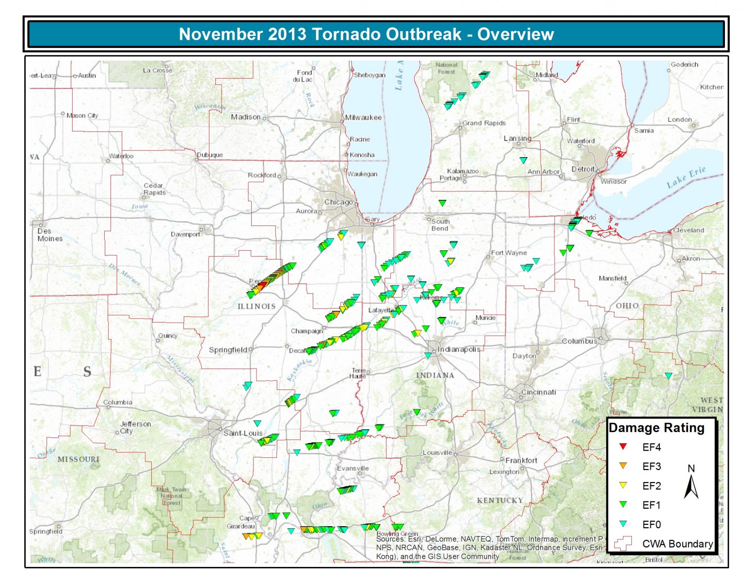
The above map is of locations where tornado damage occurred based on NWS storm surveys. Note that each report does not reflect a different tornado, with many reports clustered together or strung out in a path being caused from the same tornado.
A powerful low pressure system tracked from the central Rockies toward the southern Great Lakes on November 17th. As the system approached central Illinois, unseasonably warm and humid air was pulled northward into the area, resulting in high temperatures soaring into the 70s. This very unstable air mass, coupled with strong jet stream level winds aloft, created numerous strong to severe thunderstorms. Many of the storms became supercells, producing damaging long-track tornadoes.
The event produced a total of 25 tornadoes across the state. Click on the links for more detailed information.
| # | Nearest Cities | Counties Affected | Start Time (CST) |
Maximum Strength |
Path Length (miles) |
Fatalities | Injuries |
| 1 | Pekin | Peoria, Tazewell | 10:52 am | EF-2 | 2.5 | 0 | 10 |
| 2 | East Peoria, Washington, Minonk, Dana, Long Point | Tazewell, Woodford, La Salle, Livingston | 10:59 am | EF-4 | 46.2 | 3 | 125 |
| 3 | Litchfield | Montgomery | 11:30 am | EF-0 | 4.0 | 0 | 0 |
| 4 | Dana, Long Point (south of long-track tornado) | La Salle, Livingston | 11:43 am | EF-0 | 3.0 | 0 | 0 |
| 5 | Breese | Clinton | 11:47 am | EF-1 | 0.4 | 0 | 0 |
| 6 | New Minden | Washington | 12:04 pm | EF-4 | 10.6 | 2 | 2 |
| 7 | Hoyleton | Washington | 12:14 pm | EF-1 | 4.9 | 0 | 0 |
| 8 | Pana | Christian | 12:15 pm | EF-1 | 2.5 | 0 | 0 |
| 9 | St. Elmo, Altamont | Fayette, Effingham | 12:22 pm | EF-2 | 11.5 | 0 | 0 |
| 10 | Coal City, Wilmington | Grundy, Will | 12:22 pm | EF-2 | 12.9 | 0 | 5 |
| 11 | West Liberty | Jasper | 12:25 pm | EF-1 | 3.5 | 0 | 0 |
| 12 | Garrett | Moultrie, Douglas | 12:30 pm | EF-1 | 9.3 | 0 | 0 |
| 13 | Manhattan, Frankfort | Will | 12:42 pm | EF-2 | 5.5 | 0 | 0 |
| 14 | Villa Grove, Broadlands | Douglas, Champaign | 12:44 pm | EF-3 | 18.0 | 0 | 0 |
| 15 | Tuscola | Douglas | 12:45 pm | EF-1 | 5.2 | 0 | 0 |
| 16 | Gifford, East Lynn, Wellington | Champaign, Vermilion, Iroquois | 12:45 pm | EF-3 | 29.7 | 0 | 6 |
| 17 | Beecher | Kankakee, Will | 1:01 pm | EF-1 | 0.8 | 0 | 0 |
| 18 | Allerton, Westville | Vermilion | 1:03 pm | EF-2 | 19.7 | 0 | 1 |
| 19 | Opdyke | Jefferson | 1:05 pm | EF-1 | 0.1 | 0 | 0 |
| 20 | Sims, Fairfield | Wayne | 1:08 pm | EF-2 | 10.0 | 0 | 0 |
| 21 | Wellington | Iroquois | 1:19 pm | EF-0 | 4.6 | 0 | 0 |
| 22 | Albion (north tornado) | Wayne, Edwards | 1:29 pm | EF-2 | 8.0 | 0 | 0 |
| 23 | Albion (south tornado) | Wayne, Edwards | 1:30 pm | EF-2 | 8.0 | 0 | 0 |
| 24 | Bellmont, Allendale | Wabash | 1:44 pm | EF-2 | 10.0 | 0 | 1 |
| 25 | Brookport, New Liberty | Massac, Pope | 2:23 pm | EF-3 | 11.0 * | 3 | 33 |
| Totals: | 8 | 183 |
* - Total track was 42 miles, 31 of which were in Kentucky.
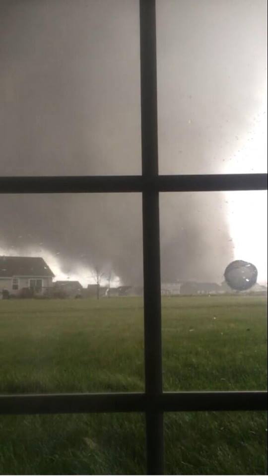 |
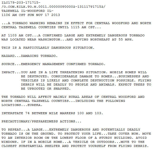
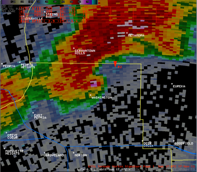 Left: Anthony Khoury took this picture of the Washington tornado. Above: Radar imagery of the Washington area corresponding to the time of the picture. The white and pink radar echoes are caused by airborne debris reflecting off the radar beam. Right: An update to the Tornado Warning issued a few minutes before the tornado struck Washington. |
  |
|
|
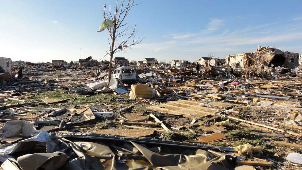
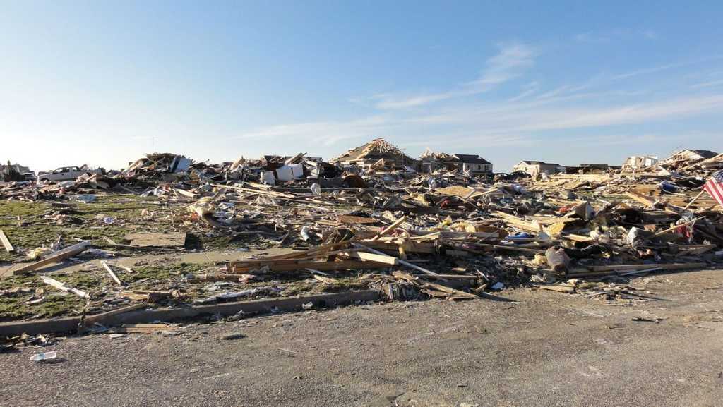
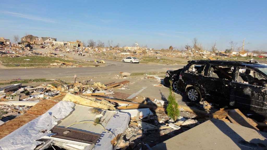
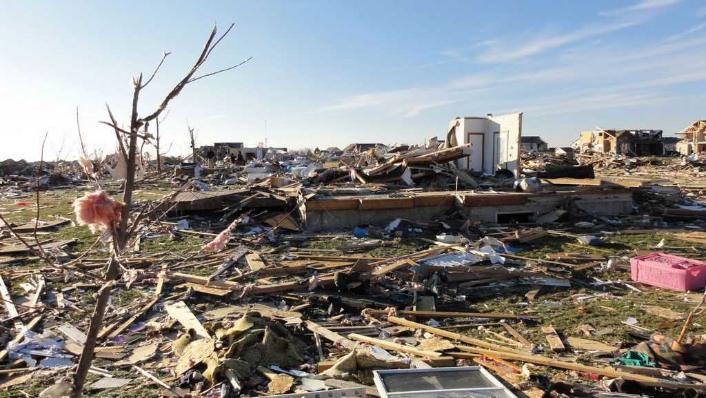
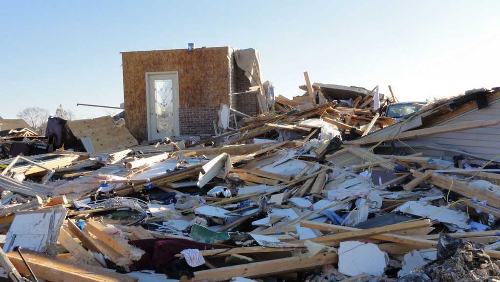
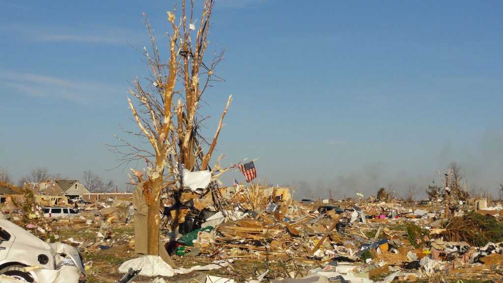
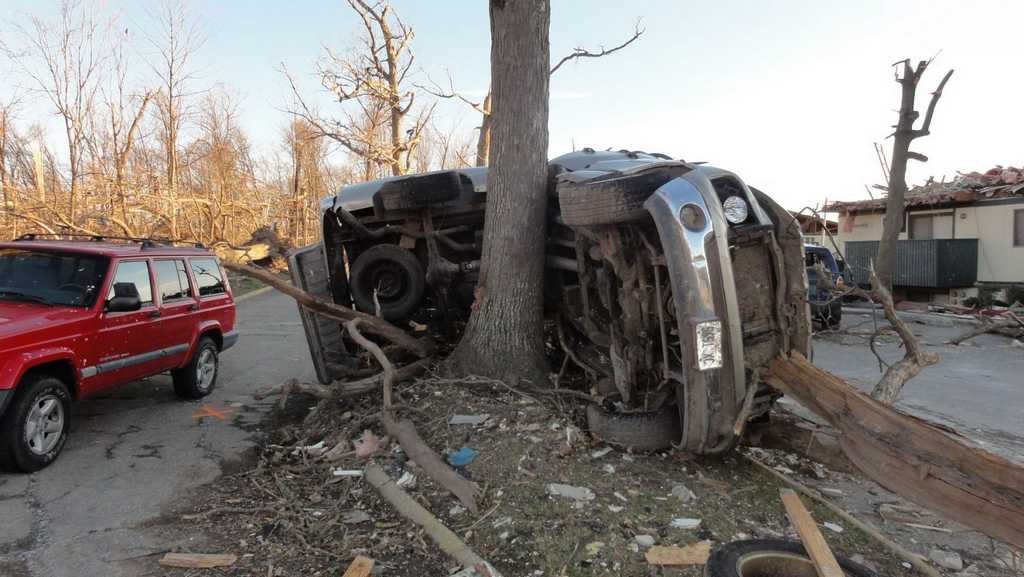
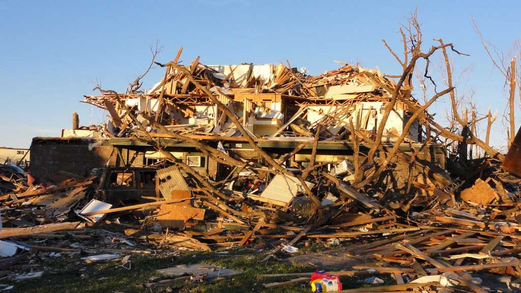
Damage pictures from Washington: |
|||
 |
 |
  |
|
 |
 |
  |
|
 |
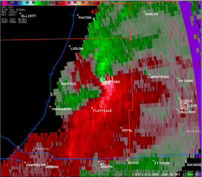
The tornado which went through Gifford, in Champaign County, tracked for nearly 30 miles, crossing northwest Vermilion and far southern Iroquois Counties. Jessie Starkey photographed the storm when it was near Gifford. The radar image displayed here, taken at about the same time as Jessie's photo, shows the motions within the storm. A strong circulation is shown where the bright green and bright red colors come together. |
|
|
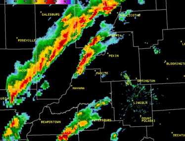
This image, courtesy of the NWS office in Chicago, is centered on the storm that produced the EF-4 tornado in Washington. As such, instead of seeing the storm itself move off the screen, the county background is adjusting as the storm moves northeast. The storm eventually reached the Chicago metro area. While no tornadoes were reported in downtown Chicago, the arrival of this storm prompted a 2-hour delay in the Chicago Bears game that was ongoing at Soldier Field. |
|
 |
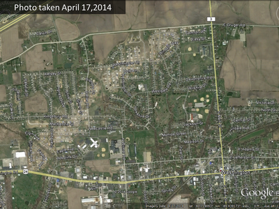 |
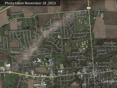
These Google Earth satellite images of Washington were taken 6 months apart. The one at left was taken the day after the tornado, and the one at right was taken in April 2014. The scar on the landscape was still clearly visible several months later. |
 |
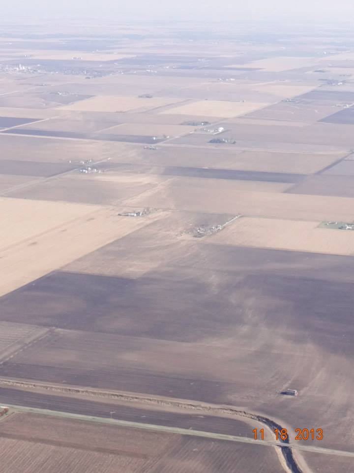 |
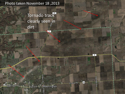
A close-up look of the Washington track in Google Earth (left image) showed swirls in the dirt, clearly seen in the barren farm fields. This was seen across most of the track through Woodford County and even into LaSalle and Livingston Counties. At right, in this picture taken by the Illinois Emergency Management Agency, the swirls in the dirt are seen along the Gifford tornado track. |
Why So Few Deaths?
In the days following the storm, the one question we kept getting asked, over and over, from media outlets across the country (and outside the country; we actually did an interview with a radio station in Japan!), was this:
With so much destruction, why were the numbers of fatalities and injuries lower than other recent, but similarly strong, tornado events across the country?
We will never know all the reasons, but there was a rather consistent theme:
How Well Was This Forecast?
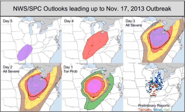 Outlooks for Sunday, November 17 issued from the Storm Prediction Center. Top row (L-R): Forecasts issued on Wednesday, Thursday, and Friday. Bottom row (L-R): Forecasts issued Saturday and Sunday, and a mapping of the received reports. |
|
Learning More:
For more information about this outbreak in Illinois, the NWS offices that cover the area have set up special web pages. They contain more detailed information on the exact tracks of each system, radar imagery, and more.
Several YouTube videos are available of the tornadoes and aftermath. Search for "Washington Tornado 2013" and "Gifford Tornado 2013".