Overview
A strong winter storm moved across much of the Midwest ahead of Christmas bringing strong winds, dangerously cold wind chills, and snow.
The event began Thursday night with rain followed by a frontal passage which brought a rapid 25 degree temperature fall which caused a flash freeze of the residual moisture on the ground. Snow then fell for several hours with 1-3 inches of accumulation across central Indiana. Strong winds also arrived in the aftermath of the frontal passage with gusts up to 56 mph by the morning hours on Friday. Temperatures continued to fall Thursday night with lows well below zero and wind chills approaching 40 below zero.
Cold conditions continued through the day on Friday with blowing snow throughout the day. Numerous travel hazards were caused by the combination of ice on the roads and the blowing snow which continued into Saturday. Another concern was the extreme cold which caused issues for snow clearing equipment. Numerous accidents were caused by the snow and ice.
Snowfall and Visibility
Snow amounts were generally between 1 and 3 inches, but the extent of the blowing snow made measurements very difficult. The combination of the flash freeze, extreme cold, high winds, and snow led to significant travel issues ahead of the Christmas holiday travel.
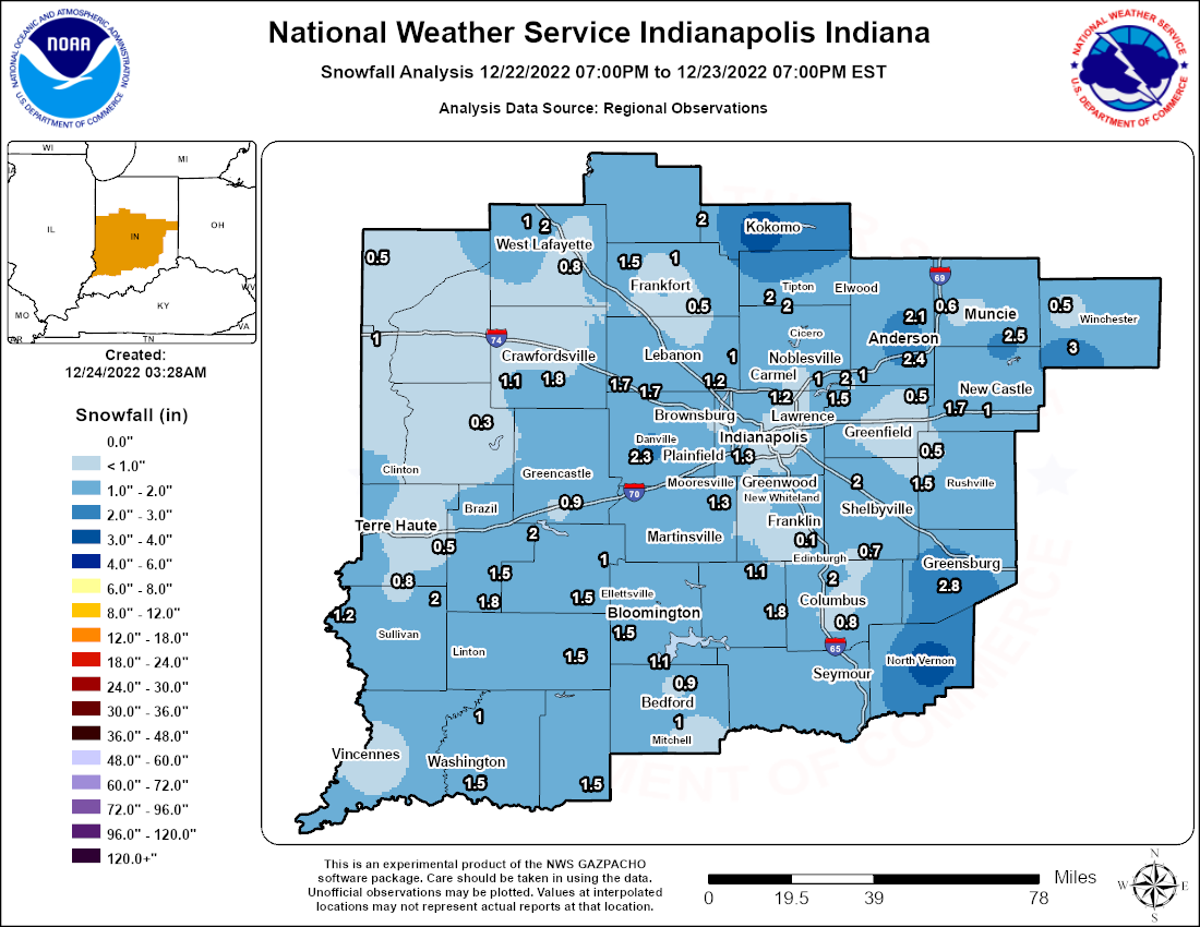
...SNOWFALL TOTALS for Late 12/22 -to- 700 AM EST 12/24...
I. GREATEST REPORTS for each COUNTY, where 2.5 or greater...
County Location Snowfall Source
JENNINGS North Vernon 2 ESE 3.5 in COOP
DAVIESS Elnora 3.0 in COOP
RUSH Modoc 3.0 in CoCoRaHS
DECATUR Greensburg 6.0 SW 2.8 in CoCoRaHS
HOWARD Kokomo 3 WSW 2.8 in COOP
MADISON Anderson 2.0 S 2.8 in CoCoRaHS
DELAWARE Macedonia 2.5 in CoCoRaHS
SHELBY Fairland 0.9 SSW 2.5 in CoCoRaHS
II. STORM TOTAL SNOWFALL REPORTS, by county...
Central Indiana location Amount Time/Date Provider
...Bartholomew County...
Columbus 2.1 ENE 2.2 in 700AM 12/24 CoCoRaHS
Taylorsville 0.8 SSW 2.2 in 700AM 12/24 CoCoRaHS
Columbus 0.8 in 700AM 12/24 COOP
Flat Rock 1.2 SSW 0.7 in 700AM 12/24 CoCoRaHS
...Boone County...
Jamestown 2 E 1.7 in 700AM 12/23 COOP
Lebanon 6 W 1.3 in 700AM 12/24 COOP
Zionsville 1.2 in 700AM 12/24 CoCoRaHS
Whitestown 3.1 E 1.0 in 700AM 12/24 CoCoRaHS
...Brown County...
Needmore 1.7 SSW 1.8 in 700AM 12/24 CoCoRaHS
Beanblossom 1.4 NE 1.1 in 700AM 12/24 CoCoRaHS
Stone Head 2.3 ENE 1.0 in 700AM 12/24 CoCoRaHS
...Carroll County...
Burlington 2.0 in 700AM 12/24 CoCoRaHS
...Clay County...
Bowling Green 1 W 2.0 in 700AM 12/24 COOP
Howesville 1.8 in 700AM 12/24 CoCoRaHS
...Clinton County...
Mulberry 0.6 SSE 1.5 in 700AM 12/23 CoCoRaHS
Frankfrot 0.9 SSE 1.2 in 700AM 12/24 CoCoRaHS
Frankfort 4.9 NNE 1.0 in 700AM 12/24 CoCoRaHS
...Daviess County...
Elnora 3.0 in 400PM 12/24 COOP
Washington 3.3 SE 1.5 in 700AM 12/24 CoCoRaHS
Plainfield 1.3 S 1.0 in 700AM 12/24 CoCoRaHS
...Decatur County...
Greensburg 6.0 SW 2.8 in 700AM 12/24 CoCoRaHS
...Delaware County...
Macedonia 2.5 in 700AM 12/24 CoCoRaHS
Muncie WWTP 2.0 in 700AM 12/24 COOP
Muncie 1.6 WNW 0.7 in 700AM 12/24 CoCoRaHS
Yorktown 1.1 NNW 0.6 in 700AM 12/24 CoCoRaHS
...Greene County...
Bloomfield 5.3 ENE 1.5 in 700AM 12/24 CoCoRaHS
Stanford 1.8 SSW 1.5 in 700AM 12/24 CoCoRaHS
...Hamilton County...
Carmel 1.5 W 2.0 in 700AM 12/24 CoCoRaHS
Westfield 1.4 ESE 2.0 in 700AM 12/24 CoCoRaHS
McCordsville 2.6 NE 2.0 in 700AM 12/24 CoCoRaHS
Fishers 4.3 ENE 1.0 in 700AM 12/24 CoCoRaHS
Noblesville 4.4 ESE 1.0 in 700AM 12/24 CoCoRaHS
...Hancock County...
Greenfield WWTP 0.5 in 700AM 12/24 COOP
Willow Branch 0.5 in 700AM 12/23 CoCoRaHS
...Hendricks County...
Danville 3 SW 2.3 in 700AM 12/24 COOP
Brownsburg 0.8 NNW 1.7 in 700AM 12/24 NWS Emply
Avon 1.4 WNW 1.6 in 700AM 12/24 CoCoRaHS
Brownsburg 5.1 NNE 1.3 in 700AM 12/23 CoCoRaHS
...Henry County...
Lewisville 1.8 ENE 2.0 in 700AM 12/24 CoCoRaHS
New Castle 5.4 WSW 1.7 in 700AM 12/23 CoCoRaHS
New Castle 3 SW 1.0 in 700AM 12/24 CoCoRaHS
...Howard County...
Kokomo 3 WSW 2.8 in 700AM 12/24 COOP
Young America 2.7 in 700AM 12/24 CoCoRaHS
...Jennings County...
North Vernon 2 ESE 3.5 in 700AM 12/24 COOP
...Johnson County...
Franklin 1 W 1.5 in 700AM 12/24 COOP
Franklin WWTP 1.3 in 700AM 12/24 COOP
Greenwood 2.6 W 1.3 in 700AM 12/24 CoCoRaHS
Greenwood 4.9 SW 0.8 in 700AM 12/24 CoCoRaHS
...Knox County...
Vincennes 4 E 0.8 in 700AM 12/24 COOP
...Lawrence County...
Oolitic Purdue Ex Farm 1.3 in 700AM 12/24 COOP
Harrodsburg 2.9 SSW 1.2 in 700AM 12/24 CoCoRaHS
Mitchell 4.1 E 1.1 in 700AM 12/24 CoCoRaHS
Mitchell 2.1 N 1.0 in 700AM 12/24 CoCoRaHS
Oolitic 2.8 ENE 0.9 in 700AM 12/24 CoCoRaHS
...Madison County...
Anderson 2.0 S 2.8 in 700AM 12/24 CoCoRaHS
Anderson 2.5 in 700AM 12/24 CoCoRaHS
Anderson 4.0 N 2.1 in 700AM 12/24 CoCoRaHS
Ingalls 3.0 WNW 1.0 in 700AM 12/24 CoCoRaHS
...Marion County...
Castleton 2 S 1.8 in 700AM 12/24 COOP
Indianapolis Intl AP 1.1 S 1.6 in 700AM 12/24 NWS WFO
McCordsville 1.3 W 1.6 in 700AM 12/24 CoCoRaHS
Speedway 1.5 in 700AM 12/24 CoCoRaHS
Millersville 1.0 in 700AM 12/24 CoCoRaHS
Fountain Square 0.9 SSW 0.9 in 700AM 12/24 CoCoRaHS
Williams Creek 0.7 in 700AM 12/24 CoCoRaHS
Clermont 1.1 N 0.6 in 700AM 12/24 CoCoRaHS
...Martin County...
Shoals 4.0 E 1.5 in 700AM 12/23 CoCoRaHS
Shoals 8 S 1.5 in 700AM 12/24 COOP
...Monroe County...
Ellettsville 2.7 NE 2.0 in 700AM 12/23 CoCoRaHS
Ellettsville 0.5 W 1.5 in 700AM 12/24 CoCoRaHS
Bloomington 4.1 SSW 1.2 in 700AM 12/23 CoCoRaHS
...Montgomery County...
Crawfordsville 6 SE 1.8 in 700AM 12/24 COOP
New Market 2.6 WNW 1.3 in 700AM 12/24 NWS Emply
...Morgan County...
Brooklyn 1.5 in 700AM 12/24 NWS Emply
Mooresville 1.8 NE 1.1 in 700AM 12/24 CoCoRaHS
Martinsville 2 SW 1.0 in 700AM 12/24 COOP
...Owen County...
Spencer WWTP 2.0 in 700AM 12/24 COOP
Freeman 2.7 NE 1.6 in 700AM 12/24 CoCoRaHS
Freeman 2.4 WSW 1.5 in 700AM 12/24 CoCoRaHS
Gosport 4.0 WSW 1.0 in 700AM 12/23 CoCoRaHS
...Parke County...
Rockville 3.6 ENE 0.3 in 700AM 12/24 CoCoRaHS
...Putnam County...
Greencastle 3.6 ESE 2.0 in 700AM 12/24 CoCoRaHS
Cloverdale 3.5 W 0.9 in 700AM 12/24 CoCoRaHS
...Randolph County...
Farmland 0.5 in 700AM 12/24 CoCoRaHS
...Rush County...
Modoc 3.0 in 700AM 12/23 CoCoRaHS
Rushville 0.7 ENE 2.0 in 700AM 12/23 CoCoRaHS
Homer 1.5 in 700AM 12/24 CoCoRaHS
Morristown 3.8 ENE 0.5 in 700AM 12/24 CoCoRaHS
...Shelby County...
Fairland 0.9 SSW 2.5 in 700AM 12/24 CoCoRaHS
Shelbyville 7.1 WSW 2.0 in 700AM 12/24 CoCoRaHS
Shelbyville 1.6 SSE 1.5 in 700AM 12/24 CoCoRaHS
...Sullivan County...
Hymera 2.0 in 700AM 12/24 CoCoRaHS
Graysville 5 WNW 1.2 in 700AM 12/24 COOP
...Tippecanoe County...
West Lafayette 3.3 WNW 2.0 in 700AM 12/24 CoCoRaHS
Battle Ground 4.9 WNW 1.0 in 700AM 12/24 CoCoRaHS
Lafayette 2.2 S 0.8 in 700AM 12/24 CoCoRaHS
Lafayette 2.2 NE 0.6 in 700AM 12/24 CoCoRaHS
...Tipton County...
Tipton 5 SW 2.0 in 700AM 12/24 COOP
...Vermillion County...
Perrysville 4 WNW 1.0 in 700AM 12/24 COOP
...Vigo County...
Shepardsville 3.8 SE 1.0 in 700AM 12/23 CoCoRaHS
Riley 0.3 NNW 0.5 in 700AM 12/23 CoCoRaHS
...Warren County...
Pence 1 SW 0.5 in 700AM 12/24 COOP
Observations are collected from a variety of sources with varying
equipment and exposures. We thank all volunteer weather observers
for their dedication. Not all data listed are considered official.
********************************************************************************************
Generally 1-3" of snowfall and strong winds combined to produce
blowing snow that reduced visibility across the region. Blizzard
conditions did not occur, although near-blizzard conditions were
observed at Kokomo through the late morning and noon hour on
12/23/2022.
MINIMUM OBSERVED VISIBILITY...
Central IN ASOS/AWOS VIS FIRST OB LAST OBS
A IND Indianapolis Intl AP 0.50 22/1139P 23/0154A
S LAF Lafayette Purdue Univ AP 0.50 22/ 500P 22/ 520P
O HUF Terre Haute Hulman Reg AP 0.25 22/ 455P 22/ 520P
S BMG Bloomington Monroe Co AP 0.25 23/ 500P 23/ 500P
MIE Muncie Delaware County AP 0.50 22/ 645P 23/ 140P
GEZ Shelbyville Municipal AP 0.75 23/1235A 23/ 133A
EYE Eagle Creek Airpark 0.50 22/ 455P 23/ 245A
--------------------------------------------------------
A AID Anderson Municipal AP 1.00 23/1035A 23/1135A
W BFR Bedford Municipal AP 1.25 22/ 715P 23/ 135P
O DCY Daviess County AP 1.00 22/1035P 22/1155P
S GPC Greencastle 0.75 22/ 535P 23/ 535P
OKK Kokomo Municipal AP 0.25 23/ 115A 23/ 856P
**Longest consecutive duration 23rd/~930A-1230P**
TYQ Zionsville 0.75 22/ 455P 23/1135A
UMP Fishers Indy Metro AP 1.00 23/ 955A 23/ 955A
HFY Greenwood Indy South AO 0.75 23/1235A 23/ 935A
MQJ Mt. Comfort Indy Reg AP 1.00 23/ 235A 23/ 235A
ALL TIMES LT (Eastern Standard)
Wind chills dropped to up to 40 below zero across much of central Indiana late Thursday night into Friday. This dangerous cold would then continue through Sunday with over 60 consecutive hours of subzero wind chills.
.png)
    DURATION OF MOST EXTREME WIND CHILLS (-30*F OR LOWER)
ARRANGED BY TOTAL...WHICH IS A COUNT OF HOURLY OBS AT/BELOW -30*F
                                 LOWEST    -30 DEGREES OR LOWER
 COUNTY     ASOS/AWOS STATION    WIND C.  FIRST    LAST    TOTAL

 HOWARD     OKK KOKOMO	   	   -40   23/1240  24/0245   17HR
 BOONE      TYQ ZIONSVILLE	   -40   23/0135  23/1815   16
 HANCOCK    MQJ MT. COMFORT	   -39   23/0115  23/1755   16
 MARION     IND INDIANAPOLIS       -32   23/0120  23/1715   14
 DELAWARE   MIE MUNCIE		   -38   23/0315  23/1725   11
 TIPPECANOE LAF LAFAYETTE	   -38	 22/2354  23/1225   11
 PUTNAM     GPC GREENCASTLE	   -37   23/0155  23/1355   11
 VIGO       HUF TERRE HAUTE	   -33   23/0025  23/1036    9
 SHELBY     GEZ SHELBYVILLE	   -35   23/0250  23/1100    8
 DAVIESS    DCY WASHINGTON	   -33   23/0215  23/0900    7
 MADISON    AID ANDERSON	   -37   23/0245  23/1040    6
 JOHNSON    HFY GREENWOOD	   -36   23/0335  23/1140    6
 MONROE     BMG BLOOMINGTON	   -34   23/0200  23/1109    5
 HAMILTON   UMP FISHERS		   -34   23/0415  23/1115    4
 LAWRENCE   BFR BEDFORD-GRISSOM    -31   23/0355  23/0935    2
 MARION     EYE EAGLE CREEK APK    -32   23/0145        M    M


    LOWEST WIND CHILL REPORTS FOR EACH CENTRAL INDIANA COUNTY

 COUNTY       INDIANA LOCATION       LOWEST WC  DAY/TIME SOURCE

 HAMILTON     WESTFIELD 1 WSW            -46 F  23/0510  AWS
 CLINTON      FRANKFORT                  -43 F  23/0600  MESONET
 PUTNAM       CLOVERDALE 0.8 N           -43 F  23/0410  INDOT
 BOONE        WHITESTOWN 1.8 SE          -41 F  23/0650  MESONET
 MADISON      I-69 AND SCATTERFIELD RD   -41 F  23/0626  MESONET
 RUSH         MANILLA                    -41 F  23/0930  AWS
 SHELBY       SHELBYVILLE 1 SSW          -41 F  23/0625  AWS
 HENRY        LEWISVILLE 3.3 N           -40 F  23/0610  INDOT
 HOWARD       GALVESTON 2 SW             -40 F  23/0605  AWS
 JOHNSON      TRAFALGAR                  -40 F  23/0444  AWS
 MARION       HOMECROFT 1 NE             -40 F  23/0755  AWS
 MONTGOMERY   NEW MARKET 1 ESE           -40 F  23/0644  AWS
 RANDOLPH     LYNN                       -40 F  23/0900  DAVIS
 DECATUR      GREENSBURG                 -39 F  23/0655  AWS
 HANCOCK      MT. COMFORT INDY REG AP    -39 F  23/0615  AWOS
 DELAWARE     GASTON                     -38 F  23/0540  DAVIS
 HENDRICKS    BROWNSBURG N1              -38 F  23/0700  AGS
 MONROE       WHITEHALL 1.5 NE           -38 F  23/0810  INDOT
 PARKE        BELLMORE                   -38 F  23/0718  CWOP
 TIPPECANOE   PURDUE UNIVERSITY AIRPORT  -38 F  23/0454  ASOS
 TIPTON       KEMPTON                    -38 F  23/0850  DAVIS
 VERMILLION   FAIRVIEW PARK 3 NNE        -37 F  23/0225  AWS
 BARTHOLOMEW  COLUMBUS                   -36 F  23/0830  MESONET
 JACKSON      CORTLAND 4.2 S             -36 F  23/0740  INDOT
 KNOX         VINCENNES 4.5 SW           -35 F  23/0700  INDOT
 SULLIVAN     SULLIVAN 1 WSW             -35 F  23/0615  AWS
 VIGO         RILEY 3.2 NW               -34 F  23/0400  INDOT
 DAVIESS      DAVIESS COUNTY AIRPORT     -33 F  23/0735  AWOS
 JENNINGS     NORTH VERNON               -33 F  23/0840  AWS
 LAWRENCE     VIRGIL I GRISSOM AIRPORT   -31 F  23/0755  AWOS
 MORGAN       MOORESVILLE                -30 F  23/0433  CWOP
 BROWN        SPEARSVILLE 3 SSE          -28 F  23/0925  AWS
 MARTIN       LOOGOOTEE 0.7 S            -28 F  23/0540  INDOT
-----------------------------------------------------------------
 OWEN         SPENCER                    -24 F  23/0445  CWOP
 GREENE       SHAWNEE HILLS FARM PERM    -20 F  23/0330  MESONET


        MINIMUM REPORTED WIND CHILLS, ARRANGED BY COUNTY

                                   LOWEST
CENTRAL INDIANA LOCATION          WC TEMP   TIME/DATE   SOURCE

...BARTHOLOMEW COUNTY...
COLUMBUS                           -36 F  0830AM 12/23  MESONET
COLUMBUS MUNICIPAL AIRPORT         -36 F  0845AM 12/23  AWOS

...BOONE COUNTY...
WHITESTOWN 1.8 SE                  -41 F  0650AM 12/23  MESONET
INDIANAPOLIS EXECUTIVE AIRPORT     -40 F  0455AM 12/23  AWOS
ZIONSVILLE                         -32 F  0310AM 12/23  MESONET
WHITESTOWN 4.5 S                   -32 F  0559AM 12/23  INDOT
ADVANCE                            -26 F  0505AM 12/23  DAVIS
LEBANON                            -20 F  0916AM 12/23  CWOP
...BROWN COUNTY...
SPEARSVILLE 3 SSE                  -28 F  0925AM 12/23  AWS

...CLINTON COUNTY...
FRANKFORT                          -43 F  0600AM 12/23  MESONET
CLARKS HILL 2 NE                   -42 F  0324AM 12/23  AWS
MICHIGANTOWN 2 S                   -40 F  0740AM 12/23  AWS
MICHIGANTOWN                       -37 F  0850AM 12/23  DAVIS
ROSSVILLE                          -34 F  0335AM 12/23  AWS

...DAVIESS COUNTY...
DAVIESS COUNTY AIRPORT             -33 F  0735AM 12/23  AWOS
WASHINGTON E                       -31 F  0500AM 12/23  IGS
ODON                               -28 F  0555AM 12/23  DAVIS
WASHINGTON                         -26 F  0840AM 12/23  CWOP

...DECATUR COUNTY...
GREENSBURG                         -39 F  0655AM 12/23  AWS
GREENSBURG                         -37 F  0820AM 12/23  INDOT
LAKE SANTEE                        -25 F  1045AM 12/23  CWOP

...DELAWARE COUNTY...
GASTON                             -38 F  0540AM 12/23  DAVIS
MUNCIE                             -38 F  0724AM 12/23  ASOS

...GREENE COUNTY...
SHAWNEE HILLS FARM PERMACULT       -20 F  0330AM 12/23  MESONET

...HAMILTON COUNTY...
WESTFIELD 1 WSW                    -46 F  0510AM 12/23  AWS
CARMEL 1 WSW                       -42 F  0844AM 12/23  AWS
NOBLESVILLE                        -39 F  0630AM 12/23  CWOP
FISHERS 3 ENE                      -39 F  0800AM 12/23  AWS
FISHERS                            -36 F  0527AM 12/23  CWOP
INDIANAPOLIS METRO AIRPORT         -34 F  0715AM 12/23  AWOS
ATLANTA                            -33 F  0411AM 12/23  DAVIS
FORTVILLE 4 NW                     -32 F  0730AM 12/23  AWS
US-31 AND IN-38                    -31 F  0600PM 12/23  MESONET
LAPEL 2 W                          -29 F  0600AM 12/23  AWS
US-31 AND IN-32                    -23 F  0550PM 12/23  MESONET

...HANCOCK COUNTY...
MT. COMFORT INDIANAPOLIS REG AP    -39 F  0615AM 12/23  AWOS
GREENFIELD                         -37 F  0955AM 12/23  DAVIS
FORTVILLE 2 S                      -33 F  0355PM 12/23  AWS
FORTVILLE                          -26 F  0930AM 12/23  CWOP

...HENDRICKS COUNTY...
BROWNSBURG N1                      -38 F  0700AM 12/23  IGS
CLAYTON                            -34 F  0350AM 12/23  DAVIS
BROWNSBURG N2                      -33 F  0900AM 12/23  IGS
BROWNSBURG                         -32 F  0759AM 12/23  CWOP
AVON                               -28 F  1035AM 12/23  CWOP

...HENRY COUNTY...
LEWISVILLE 3.3 N                   -40 F  0610AM 12/23  INDOT
NEW CASTLE                         -37 F  0715AM 12/23  CWOP

...HOWARD COUNTY...
GALVESTON 2 SW                     -40 F  0605AM 12/23  AWS
KOKOMO                             -40 F  0649AM 12/23  AWOS
DUNLAP FAMILY FARM                 -32 F  0700AM 12/23  MESONET

...JACKSON COUNTY...
CORTLAND 4.2 S                     -36 F  0740AM 12/23  INDOT
SEYMOUR                            -31 F  0547AM 12/23  CWOP
BROWNSTOWN                         -30 F  0410AM 12/23  DAVIS
FREETOWN                           -24 F  0758AM 12/23  CWOP

...JENNINGS COUNTY...
NORTH VERNON                       -33 F  0840AM 12/23  AWS
SOUTHEAST PURDUE AG CENTER         -33 F  0900AM 12/23  MESONET

...JOHNSON COUNTY...
TRAFALGAR                          -40 F  0444AM 12/23  AWS
GREENWOOD INDY SOUTH AIRPORT       -36 F  0455AM 12/23  AWOS
EDINBURGH 3.8 NW                   -33 F  0659AM 12/23  INDOT
FRANKLIN                           -33 F  0710AM 12/23  DAVIS
FRANKLIN 1 WSW                     -33 F  0934AM 12/23  AWS

...KNOX COUNTY...
VINCENNES 4.5 SW                   -35 F  0700AM 12/23  INDOT
OAKTOWN 1 NNE                      -33 F  0355AM 12/23  AWS
SOUTHWEST PURDUE AG CENTER         -30 F  0600AM 12/23  MESONET
VINCENNES                          -28 F  0725AM 12/23  DAVIS

...LAWRENCE COUNTY...
VIRGIL I GRISSOM MUNICIPAL AIRPORT -31 F  0755AM 12/23  AWOS
BEDFORD                            -28 F  0800AM 12/23  CWOP
MITCHELL                           -28 F  0905AM 12/23  CWOP

...MADISON COUNTY...
I-69 AND SCATTERFIELD RD           -41 F  0626AM 12/23  MESONET
ALEXANDRIA                         -40 F  0535AM 12/23  DAVIS
ANDERSON                           -37 F  0627AM 12/23  CWOP
ANDERSON MUNICIPAL AIRPORT         -37 F  0635AM 12/23  AWOS
ELWOOD 2 ENE                       -35 F  0835AM 12/23  AWS
PENDLETON                          -33 F  0735AM 12/23  AWS
PENDLETON 1 SSE                    -32 F  0730AM 12/23  CWOP
LAPEL                              -28 F  0606AM 12/23  CWOP

...MARION COUNTY...
HOMECROFT 1 NE                     -40 F  0755AM 12/23  AWS
SPEEDWAY 1.4 NW                    -40 F  0759AM 12/23  INDOT
INDIANAPOLIS                       -39 F  0454AM 12/23  ASOS
NEW PALESTINE 5 WSW                -39 F  0635AM 12/23  AWS
HOMECROFT 2.7 N                    -37 F  0830AM 12/23  MESONET
EAGLE CREEK RESERVOIR 3 NE         -36 F  0349AM 12/23  AWS
MERIDIAN HILLS                     -36 F  0710AM 12/23  AWS
MONUMENT CIRCLE 1 W                -35 F  0645AM 12/23  AWS
EAGLE CREEK AIRPARK                -32 F  0244AM 12/23  ASOS
ACTON                              -31 F  0631AM 12/23  CWOP
CLERMONT                           -28 F  0445AM 12/23  CWOP
GEIST                              -22 F  0946AM 12/23  CWOP

...MARTIN COUNTY...
LOOGOOTEE 0.7 S                    -28 F  0540AM 12/23  INDOT

...MONROE COUNTY...
WHITEHALL 1.5 NE                   -38 F  0810AM 12/23  INDOT
MONROE COUNTY AIRPORT              -34 F  0816AM 12/23  ASOS
ELLETSVILLE                        -33 F  0759AM 12/23  CWOP
WHITEHALL 1.5 NE                   -31 F  0139AM 12/23  INDOT
OOLITIC 9 NE                       -26 F  0509AM 12/23  RAWS
SMITHVILLE 3 NW                    -22 F  0650AM 12/23  AWS

...MONTGOMERY COUNTY...
NEW MARKET 1 ESE                   -40 F  0604AM 12/23  AWS
COLFAX                             -38 F  0525AM 12/23  DAVIS

...MORGAN COUNTY...
MOORESVILLE                        -30 F  0433AM 12/23  CWOP
MARTINSVILLE                       -29 F  0720AM 12/23  DAVIS

...OWEN COUNTY...
SPENCER                            -24 F  0445AM 12/23  CWOP

...PARKE COUNTY...
BELLMORE                           -38 F  0718AM 12/23  CWOP
NYESVILLE                          -35 F  0729AM 12/23  CWOP
ROCKVILLE                          -35 F  0930AM 12/23  DAVIS
JUDSON                             -32 F  0125PM 12/23  CWOP

...PUTNAM COUNTY...
CLOVERDALE 0.8 N                   -43 F  0410AM 12/23  INDOT
GREENCASTLE                        -37 F  0315AM 12/23  AWOS

...RANDOLPH COUNTY...
LYNN                               -40 F  0900AM 12/23  DAVIS
RIDGEVILLE                         -39 F  0920AM 12/23  DAVIS
DAVIS PURDUE AG CENTER             -38 F  0800AM 12/23  MESONET

...RUSH COUNTY...
MANILLA                            -41 F  0930AM 12/23  AWS
LEWISVILLE                         -34 F  0725AM 12/23  DAVIS
RUSHVILLE                          -33 F  0615AM 12/23  CWOP

...SHELBY COUNTY...
SHELBYVILLE 1 SSW                  -41 F  0625AM 12/23  AWS
NEW PALESTINE                      -38 F  0845AM 12/23  CWOP
MARIETTA 2 E                       -35 F  0700AM 12/23  AWS
SHELBYVILLE                        -35 F  0828AM 12/23  ASOS
EDINBURGH                          -34 F  0810AM 12/23  CWOP

...SULLIVAN COUNTY...
SULLIVAN 1 WSW                     -35 F  0615AM 12/23  AWS
SULLIVAN 1.4 SW                    -30 F  1050AM 12/23  INDOT
SULLIVAN                           -29 F  0410AM 12/23  RAWS

...TIPPECANOE COUNTY...
PURDUE UNIVERSITY AIRPORT          -38 F  0454AM 12/23  ASOS
AGRONOMY CENTER FOR RESEARCH       -36 F  0530AM 12/23  MESONET
MARTELL FOREST                     -30 F  0630AM 12/23  MESONET
LAFAYETTE 3 NE                     -25 F  0449AM 12/23  CWOP
OTTERBEIN 4 ESE                    -23 F  0515AM 12/23  CWOP
MARTELL FOREST                     -21 F  1130PM 12/22  MESONET

...TIPTON COUNTY...
KEMPTON                            -38 F  0850AM 12/23  DAVIS
TIPTON                             -37 F  0620AM 12/23  CWOP
SHARPSVILLE                        -36 F  0835AM 12/23  DAVIS

...VERMILLION COUNTY...
FAIRVIEW PARK 3 NNE                -37 F  0225AM 12/23  AWS
COVINGTON                          -34 F  0540AM 12/23  MESONET
CLINTON                            -30 F  1000AM 12/23  CWOP

...VIGO COUNTY...
RILEY 3.2 NW                       -34 F  0400AM 12/23  INDOT
TERRE HAUTE HULMAN REGIONAL AP     -33 F  0353AM 12/23  ASOS
RILEY 3 WSW                        -21 F  0840AM 12/23  AWS
********************************************************************************************
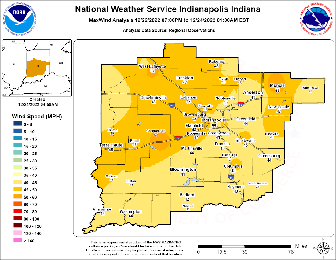
...HIGHEST WIND GUSTS, EVENING 12/22/2022 - MIDDAY 12/23/2022...

County      Central IN ASOS/AWOS      Speed    Time/Date   Source

DELAWARE    Delaware County Airport  56 MPH  1106AM 12/23  ASOS
PUTNAM      Cloverdale 0.8 N         53 MPH  0710AM 12/23  INDOT
TIPPECANOE  Purdue University AP     53 MPH  0447AM 12/23  ASOS
CLINTON     Frankfort                52 MPH  0139PM 12/23  Mesonet
BOONE       Whitestown 1.8 SE        51 MPH  0110PM 12/23  Mesonet
MARION      Indianapolis Intl AP     51 MPH  0253PM 12/23  ASOS
HOWARD      Kokomo Municipal Airport 48 MPH  0611AM 12/23  AWOS
BOONE       Indianapolis Executve AP 47 MPH  0355PM 12/23  AWOS
HAMILTON    US-31 and IN-38          47 MPH  0549PM 12/23  Mesonet
HENRY       Lewisville 3.3 N         47 MPH  0150PM 12/23  INDOT
MARION      Speedway 1.4 NW          47 MPH  0350PM 12/23  INDOT
SHELBY      New Palestine            47 MPH  0230PM 12/23  CWOP
BARTHOLOMEW Columbus Municipal AP    46 MPH  1145AM 12/23  AWOS
SHELBY      Shelbyville Municipal AP 46 MPH  1101AM 12/23  ASOS
VIGO        Riley 3.2 NW             46 MPH  0100AM 12/23  INDOT
HAMILTON    Fishers                  45 MPH  1038AM 12/23  CWOP
JOHNSON     Edinburgh 3.8 NW         45 MPH  0319AM 12/23  INDOT
MADISON     I-69 and Scatterfield Rd 45 MPH  0336AM 12/23  Mesonet
RANDOLPH    Davis Purdue AG Center   45 MPH  0130PM 12/23  Mesonet
VIGO        Terre Haute Hulman AP    45 MPH  1215PM 12/23  ASOS
-------------------------------------------------------------------
DECATUR     Greensburg               44 MPH  0230PM 12/23  INDOT
HANCOCK     Mt. Comfort Indy Reg AP  44 MPH  0315PM 12/23  AWOS
JACKSON     Cortland 4.2 S           44 MPH  0230AM 12/23  INDOT
MARION      I-65 and Georgetown Rd   44 MPH  1219PM 12/23  Mesonet
HAMILTON    Indianapolis Metro AP    43 MPH  0435PM 12/23  Mesonet
MONROE      Bloomington Monroe Co AP 43 MPH  1238AM 12/23  ASOS
PARKE       Judson                   43 MPH  0125PM 12/23  CWOP
TIPPECANOE  Agronomy Research Center 43 MPH  1230PM 12/23  Mesonet
JOHNSON     Greenwood Indy South AP  41 MPH  1115AM 12/23  AWOS
MADISON     Anderson Municipal AP    41 MPH  0615AM 12/23  AWOS
MARION      Homecroft 2.7 N          41 MPH  1120AM 12/23  Mesonet
MONROE      Whitehall 1.5 NE         41 MPH  1229PM 12/23  INDOT
SHELBY      Edinburgh                41 MPH  0327PM 12/23  CWOP
HAMILTON    US-31 and IN-32          40 MPH  0619PM 12/22  Mesonet
JENNINGS    Southeast Purdue AG Cntr 40 MPH  0500AM 12/23  Mesonet
KNOX        Vincennes 4.5 SW         40 MPH  0630PM 12/22  INDOT
PARKE       Bellmore                 40 MPH  0410PM 12/23  CWOP
RANDOLPH    Lynn                     40 MPH  1215PM 12/23  Public
VERMILLION  Clinton                  40 MPH  1000AM 12/23  CWOP
DAVIESS     Daviess County Airport   40 MPH  1035PM 12/22  AWOS

Observations are collected from a variety of sources with varying
equipment and exposures. We thank all volunteer weather observers
for their dedication. Not all data listed are considered official.

$$
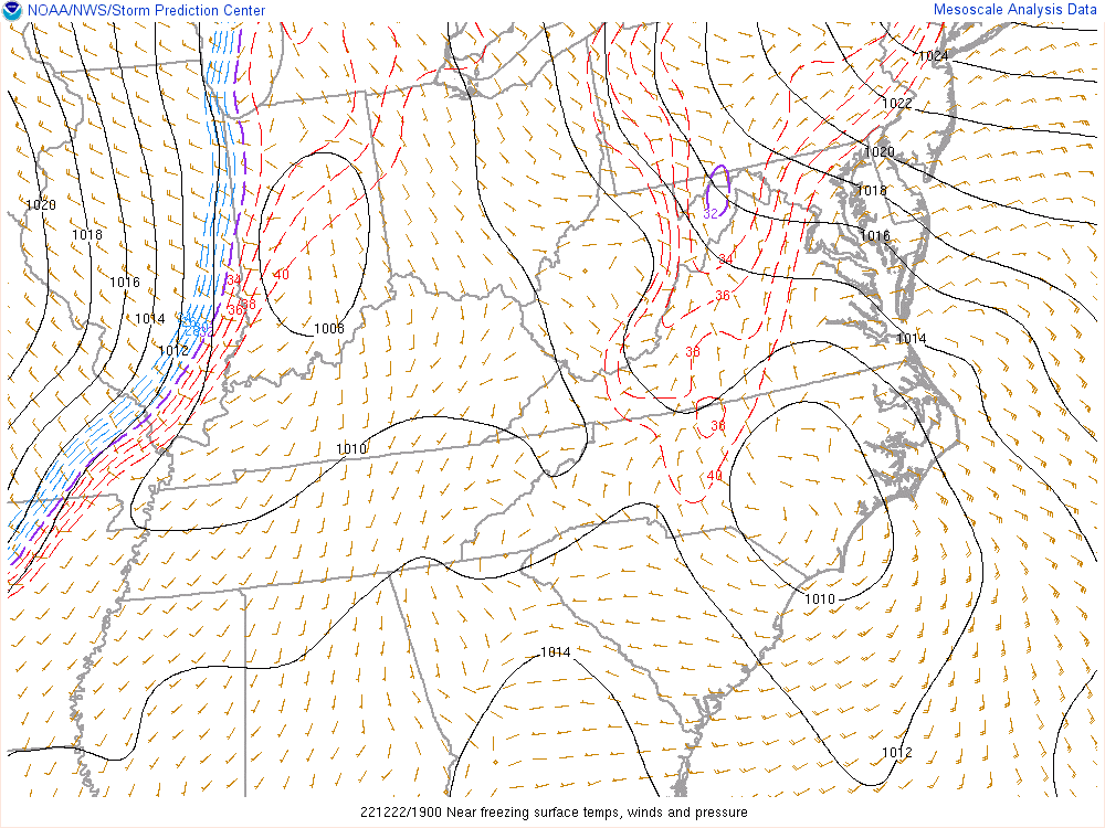
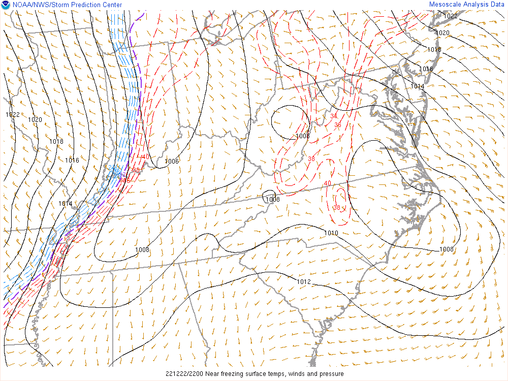
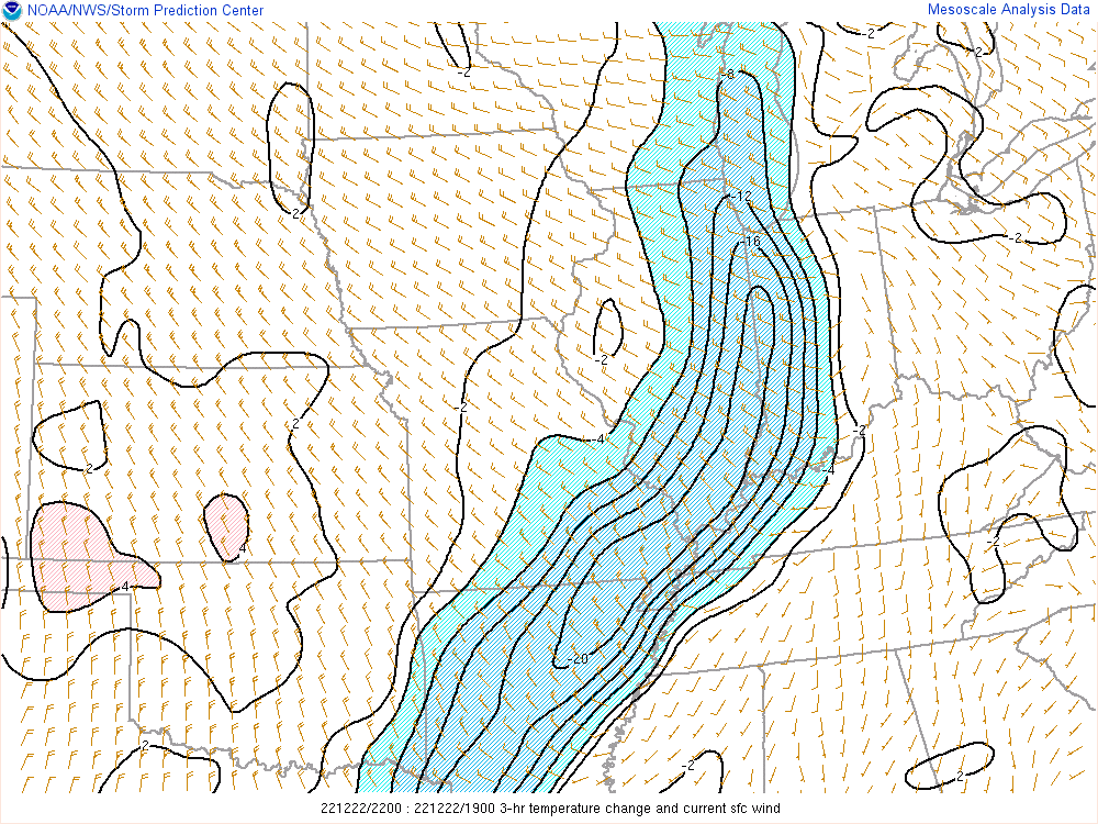
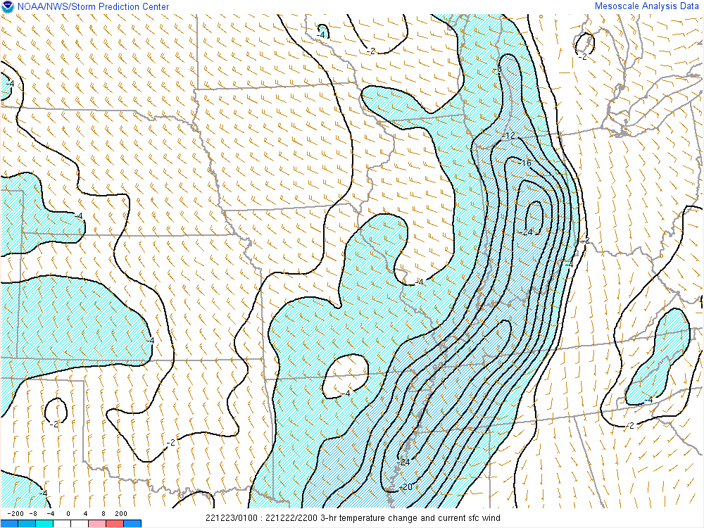
Flash Freeze / Temperatures
A flash freeze occurred late in the evening of the 22nd into the overnight hours. The images below show the progression of the colder air and how brief the dendritic growth zone was over central Indiana.
 |
 |
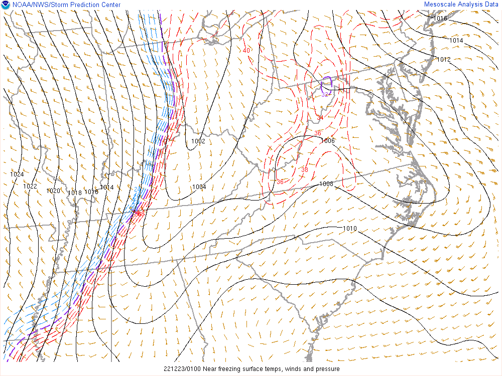 |
| Figure 1: Surface Temperature, Wind, and MSLP at 2 PM | Figure 2: Surface Temperature, Wind, and MSLP at 5 PM | Figure 3: Surface Temperature, Wind, and MSLP at 8 PM |
 |
 |
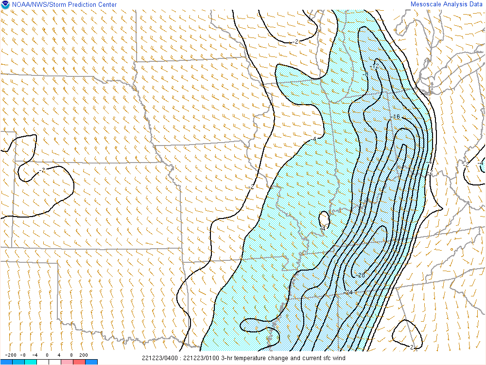 |
| Figure 4: 3 Hour Temperature Change at 5 PM | Figure 5: 3 Hour Temperature Change at 8 PM | Figure 6: 3 Hour Temperature Change at 11 PM |
The table below shows the time that it took temperatures to fall:
  RAPIDLY-FALLING TEMPERATURES ON LATE EVENING 12/22/2022...
LAG IN HOURS FROM TIME OF FRONTAL PASSAGE TO 32F...20F...5F...
                    ARRANGED CHRONOLOGICALLY

 COUNTY     ASOS/AWOS        TEMP AT FROPA TO 32F  TO 20F  TO 5F
                                      TIME

 VIGO       HUF TERRE HAUTE    37  22/1415    0.9    1.9    5.4
 PUTNAM     GPC GREENCASTLE    39  22/1435    1.7    2.6    5.7
 TIPPECANOE LAF LAFAYETTE      36  22/1450    0.5    1.2    4.4
 BOONE      TYQ ZIONSVILLE     38  22/1455    2.0    2.8    5.8
 DAVIESS    DCY WASHINGTON     41  22/1455    1.3    2.7    6.3
 MARION     EYE EAGLE CREEK AP 39  22/1550    1.3    2.1    5.0
 MONROE     BMG BLOOMINGTON    41  22/1553    1.3    2.4    5.3
 MARION     IND INDIANAPOLIS   41  22/1555    1.3    2.1    5.1
 HAMILTON   UMP FISHERS        41  22/1615    1.3    2.0    5.7
 HOWARD     OKK KOKOMO         36  22/1621    0.7    1.7    5.2
 JOHNSON    HFY GREENWOOD      42  22/1635    1.4    2.3    5.7
​ LAWRENCE   BFR BEDFORD        41  22/1635    1.3    2.6    6.0
 HANCOCK    MQJ MT. COMFORT    39  22/1655    1.0    1.9    5.0
 SHELBY     GEZ SHELBYVILLE    43  22/1735    0.8    1.8    5.7
 DELAWARE   MIE MUNCIE         43  22/1750    0.9    1.8    5.4

ALL TIMES LOCAL (EASTERN STANDARD)


*********************** LOWEST TEMPERATURES *********************

SUMMARY OF DAILY MAX/MIN TEMPS FOR ALL ASOS/AWOS/COOP SITES

                                      12-22 / ...12-23... / 12-24
  COUNTY      ASOS..AWOS..COOP        PM MN / AM MN PM MX / AM MN

A MARION      IND Indianapolis Intl     -1  /   -9    1   /   0
S TIPPECANOE  LAF Lafayette             -4  /   -9    0   /  -1
O VIGO        HUF Terre Haute           -3  /   -7    3   /   2
S MONROE      BMG Bloomington           -1  /   -9    1   /   1
  DELAWARE    MIE Muncie                 4  /   -8    1   /   0
  SHELBY      GEZ Shelbyville            3  /   -7    3   /   2
  MARION      EYE Eagle Creek Airpark    0  /    M    M   /   M
---------------------------------------------------------------
A MADISON     AID Anderson               1  /  -10    M   /  -1
W LAWRENCE    BFR Bedford-Grissom        1      -8    3   /   3
O DAVIESS     DCY Washington             0  /   -7    4   /   4
S PUTNAM      GPC Greencastle           -4  /  -10    1   /  -1
  JOHNSON     HFY Greenwood              2  /   -8    2   /   1
  HANCOCK     MQJ Mt. Comfort            0  /   -9    0   /  -2
  HOWARD      OKK Kokomo                 0  /   -9    0   /  -2
  BOONE       TYQ Zionsville            -3  /  -10   -1   /  -2
  HAMILTON    UMP Fishers                1  /   -8    2   /   1
---------------------------------------------------------------
C BARTHOLOMEW Columbus                   M  /   -7    3   /   M
O BOONE       Jamestown 2 E              M  /  -11    M   /   M
O CLINTON     Frankfort Disposal         M  /   -8    0   /   M
P DAVIESS     Elnora                     M  /   -8    M   /   M
  DAVIESS     Washington 1 W             M  /   -6    M   /   M
  HAMILTON    Carmel 3 E                 M  /  -10    2   /   M
  HANCOCK     Greenfield                 M  /  -10    0   /   M
  HENRY       New Castle 3 SW            M  /  -11   -1   /   M
  HOWARD      Kokomo 3 WSW               M  /  -11   -2   /   M
  HOWARD      Young America              M  /  -10   -1   /   M
  JENNINGS    North Vernon 2 ESE         M  /   -9    M   /   M
  JOHNSON     Franklin WWTP              M  /  -10    M   /   0
  LAWRENCE    Oolitic Purdue Ex Farm     M  /   -9    M   /   M
  MARION      Castleton 2 S             -2  /  -11   -1   /  -2
  MARION      NWS WFO Indianapolis      -3  /  -10    0   /   0
  MARTIN      Shoals 8 S                 M  /   -3    M   /   M
  MONTGOMERY  Crawfordsville 6 SE        M  /  -11   -1   /   M
  MORGAN      Martinsville 2 SW          M  /   -9    2   /   M
  OWEN        Spencer                    M  /   -8    2   /   M
  PARKE       Rockville Fire             M  /  -14    M   /   M
  RUSH        Rushville WWTP             M  /   -9    M   /   M
  SULLIVAN    Farmersburg TV-2          -4  /  -10    0   /  -1
  VERMILLION  Perrysville 4 WNW          M /   -10    M   /   M


********************* HISTORICAL PERSPECTIVE *******************

By the numbers (since the early 1870s)...1983 and 1989 have had
the two most impressive late-December arctic outbreaks...with
both years exhibiting record cold within the December 21st-26th
period.  Zooming out to the entire month, 1989 had the lowest
average minimum temperature of 151 Decembers at 9.4F...while 1983
had the second-lowest average maximum temp at 27.4F.  December
1963 was also anomalously cold, yet not particularly so through
the late month.  2000 had the most recent very cold December
(averaging 3rd coldest at 19.7F overall).

INDIANAPOLIS' LOWEST DECEMBER DAILY MAX TEMPERATURES
  1. -7 12/24/1983
  2. -4 12/25/1983
  3. -2 12/29/1880
  4. -1 12/22/1989
 T5.  1 12/23/2022** **A 30-year return!
 T5.  1 12/18/1884
 T5.  1 12/23/1989
 T5.  1 12/28/1880
 T9.  2  12/9/1876
 T9.  2 12/15/1901


RECORD LOW MAXIMUM TEMPERATURE TIED AT INDIANAPOLIS IN...
A RECORD LOW MAXIMUM TEMPERATURE OF 1 WAS TIED AT INDIANAPOLIS
ON FRIDAY, DEC 23 2022.  THIS TIED THE EXISTING RECORD SET IN
1983.
THIS WAS ONLY THE 8TH DECEMBER DAY IN THE 152-YEAR RECORD THAT
FAILED TO REACH AT LEAST 2 DEGREES.  THERE HAD NOT BEEN A
LOWER MAXIMUM TEMPERATURE AT INDIANAPOLS SINCE -4 ON JAN 18 1994.


INDIANAPOLIS' LOWEST DECEMBER DAILY MINIMUM TEMPERATURES
  1. -23 12/22/1989
  2. -21 12/21/1989
  3. -17 12/24/1983
 T4. -15  12/9/1876
 T4. -15 12/16/1951
 T4. -15 12/23/1989
 T4. -15 12/25/1983
  8. -14 12/30/1983
 T9. -13 12/28/1924
 T9. -13 12/29/1880
T27.  -9 12/23/2022*  *A 6-year return


ADDIITONAL INDIANAPOLIS LOW .DECEMBER. TEMPERATURE FACTOIDS

A) THREE CONSECUTIVE DAYS DROPPING TO ZERO OR LOWER...
Has only occurred in 13 Decembers...**A 12-YEAR RETURN**...
and last occurred in 1989 on 10 consecutive mornings...
...Considering all months, this last occurred Jan 4-6, 2018

B) THE LAST TIME IT FELL TO -9 IN DECEMBER WAS 12/24/1989...
...Considering all months, this last occurred Jan 30, 2019

C) THE LAST DAY HELD TO 1 OR LOWER WAS 12/22/1989...
...Considering all months, this last occurred Feb 3, 1996!
...While max temps this low have only occurred in 21 years
Miscellaneous
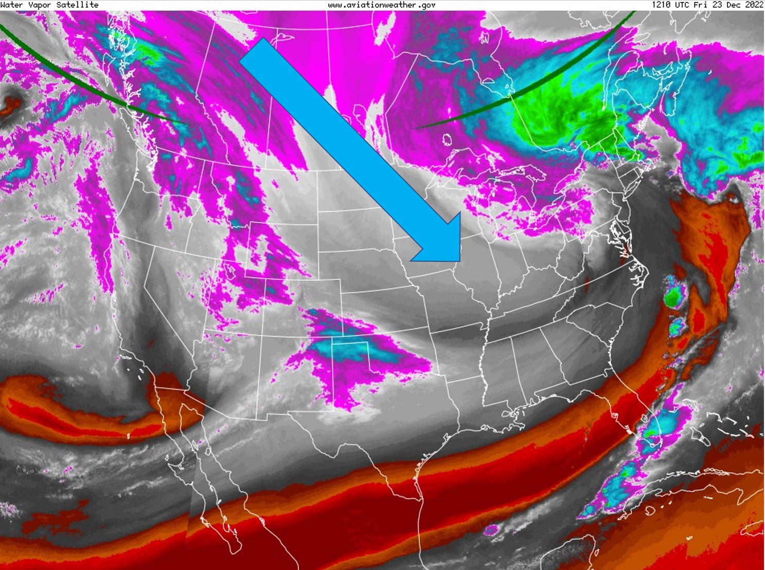
Upper Air Flow and Surface Map
 |
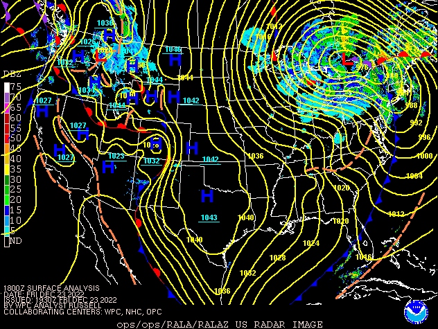 |
| Figure 1: Water Vapor Satellite Image at about 7 AM on Dec 23. Arrow shows direction of the flow into the area. | Figure 2: Surface map at 1 PM December 23, showing the intense low pressure system. |
Nearby NWS Offices' Information on this storm:
| NWS Chicago, IL | NWS Northern Indiana |
| NWS Paducah, KY | NWS Wilmington, OH |
 |
Media use of NWS Web News Stories is encouraged! Please acknowledge the NWS as the source of any news information accessed from this site. |
|

