|
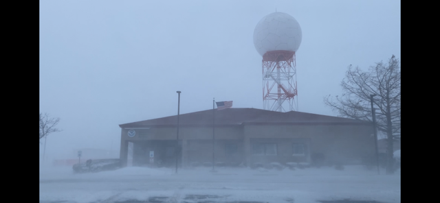
Overview A powerful Arctic cold front surged into the Midwest on Thursday, December 22nd, bringing snow, strong winds, and bitterly cold temperatures in its wake. While snowfall accumulations generally only ranged between 1 and 5 inches, a rapidly deepening area of low pressure associated with the front caused strong winds that gusted in excess of 50 mph at times and produced substantial blowing and drifting snow that led to blizzard conditions at times. Additionally, the frigid temperatures with wind chills as low as -40F mitigated the effectiveness of road treatments and allowed for many roadways to remain snow and ice-covered into Friday, December 23rd even though most of the snow had ended Thursday evening. The reduced visibilities and slippery roadways contributed to numerous automobile accidents on both days, which caused portions of I-65 and I-94 in northwest Indiana to be shut down for several hours. The cold and snowy conditions also disrupted train and air transportation before the holiday weekend, with several trains and flights being delayed or cancelled. |
|
Fast Facts
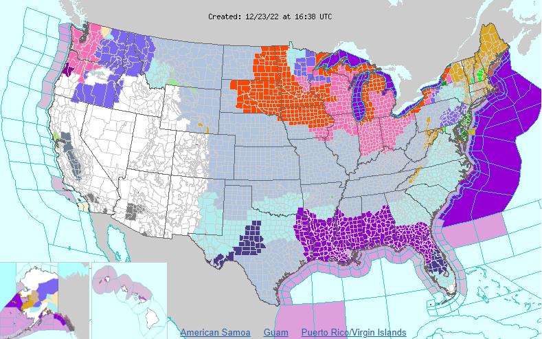 |
| Map of NWS Warnings, Watches, and Advisories from the morning of Friday, December 23rd |
Temperatures
One of the most notable impacts from the arctic blast was the dangerously cold temperatures with widespread minimum wind chills below -30°F and minimum air temperatures below -10°F. The coldest temperatures and wind chills were observed during the morning of December 23rd. Below are listings of minimum wind chills colder than -20°F and minimum air temperatures at or colder than -5°F collected form a variety of sources. December 23rd was the coldest December day in Rockford since 1989 and Chicago since 1983.
|
24-Hour Minimum Temperature (°F)
|
24-hour Minimum Wind Chill (°F)
|
Winds
In addition to the arctic cold and snow, westerly winds became strong with peak gusts measured between 45 and 55 mph in most areas. A few locations even saw wind gusts near 60 mph! The cold temperatures and strong winds led to areas of blowing snow and zero visibility, with the worst conditions observed in open and rural areas, as well as across northwestern Indiana.
...HIGHEST WIND REPORTS... Location Speed Time/Date Deerfield 60 MPH 0348 PM 12/23 Gary Airport 58 MPH 0245 PM 12/23 Montrose Beach Light 56 MPH 0544 PM 12/23 1.7 E Remington (INDOT) 54 MPH 0220 PM 12/23 Valparaiso Airport 54 MPH 0305 PM 12/23 Harrison-Dever Crib 53 MPH 0400 PM 12/23 Crown Point 53 MPH 0830 AM 12/23 Chicago Midway 53 MPH 0225 PM 12/23 Sugar Grove - Aurora Arpt. 52 MPH 0208 PM 12/23 Rockford Airport 52 MPH 0105 PM 12/23 Cline Avenue Bridge 52 MPH 0438 PM 12/23 Chicago O''Hare 51 MPH 0154 PM 12/23 Peru Airport 51 MPH 0515 PM 12/23 2 WNW Michigan City 51 MPH 0400 PM 12/23 Kouts 50 MPH 0415 PM 12/23 Elwod1 50 MPH 0325 PM 12/23 2.7 W Collegeville (INDOT) 49 MPH 0540 PM 12/23 West Chicago - DuPage Arpt. 49 MPH 0244 PM 12/23 Gurnee 48 MPH 0816 AM 12/23 Fowler 48 MPH 0320 PM 12/23 Pontiac Airport 48 MPH 0350 PM 12/23 Rensselaer Airport 48 MPH 0355 PM 12/23 Papineau 2 N (UP Rail) 48 MPH 0217 PM 12/23 Elmhurst (UP Rail) 48 MPH 0310 PM 12/23 Morris Airport 47 MPH 0220 PM 12/23 Hebron 46 MPH 0715 AM 12/23 Geneva 46 MPH 0430 PM 12/23 HOMER GLEN 46 MPH 1148 AM 12/23 Marengo 5 NW (McHenry DOT) 46 MPH 0320 PM 12/23 Harvard 4 NW (McHenry DOT) 46 MPH 1220 PM 12/23 Lansing Airport 46 MPH 1155 AM 12/23 Kankakee Airport 46 MPH 0435 PM 12/23 Sycamore 45 MPH 0256 PM 12/23 Hebron 45 MPH 0500 PM 12/23 Rosemont 45 MPH 0200 AM 12/23 Crystal Lake 45 MPH 1009 AM 12/23 Loves Park 45 MPH 0237 PM 12/23 Mount Morris 45 MPH 1201 PM 12/23 Herbert 5 ENE (McHenry DOT) 45 MPH 0120 PM 12/23 Romeoville - Lewis Airport 45 MPH 0215 PM 12/23 Wheeling - Chicago Exec. Arp 45 MPH 0640 PM 12/23 Rochelle Airport 45 MPH 0535 PM 12/23 Claytonville 2 ENE (UP Rail) 45 MPH 0200 PM 12/23 Carpentersville 44 MPH 0529 PM 12/23 Johnsburg 44 MPH 0156 PM 12/23 Waukegan Airport 44 MPH 1123 AM 12/23 Roselawn 43 MPH 0629 PM 12/23 Peotone 43 MPH 1150 AM 12/23 2 NNW Mazon 42 MPH 0330 PM 12/23 Hoffman Estates 42 MPH 0135 PM 12/23 Warrenville 42 MPH 0638 PM 12/23 Midewin RAWS 42 MPH 0405 PM 12/23 Dixon Airport 41 MPH 0239 PM 12/23 3 WNW Mazon 41 MPH 0505 AM 12/23 2 SW North Aurora 41 MPH 0246 PM 12/23 Utica 41 MPH 0615 PM 12/23 SOUTH BELOIT 41 MPH 1230 PM 12/23 CROWN POINT 41 MPH 0318 PM 12/23 Stelle 41 MPH 0310 PM 12/23 Crystal Lake (McHenry DOT) 41 MPH 0500 PM 12/23 Schaumburg Airport 41 MPH 0215 PM 12/23 Mount Prospect (UP Rail) 41 MPH 0320 PM 12/23 Harvard 6 NW (UP Rail) 41 MPH 0307 PM 12/23 Coolidge Middle School 40 MPH 0600 PM 12/23 Coal City 4 NNW 40 MPH 0700 AM 12/24 Frankfort 40 MPH 0236 PM 12/23 4 WSW Leland 40 MPH 1155 AM 12/23 6 S Lake Village 40 MPH 0335 PM 12/23 Lake Forest 40 MPH 1230 PM 12/23 Orland Park 40 MPH 1100 AM 12/23 Naperville 40 MPH 0500 PM 12/23 McHenry (McHenry DOT) 40 MPH 0150 PM 12/23 Joliet Airport 40 MPH 0215 PM 12/23 3 NNW Watseka 39 MPH 0700 AM 12/23 |
Snow Totals
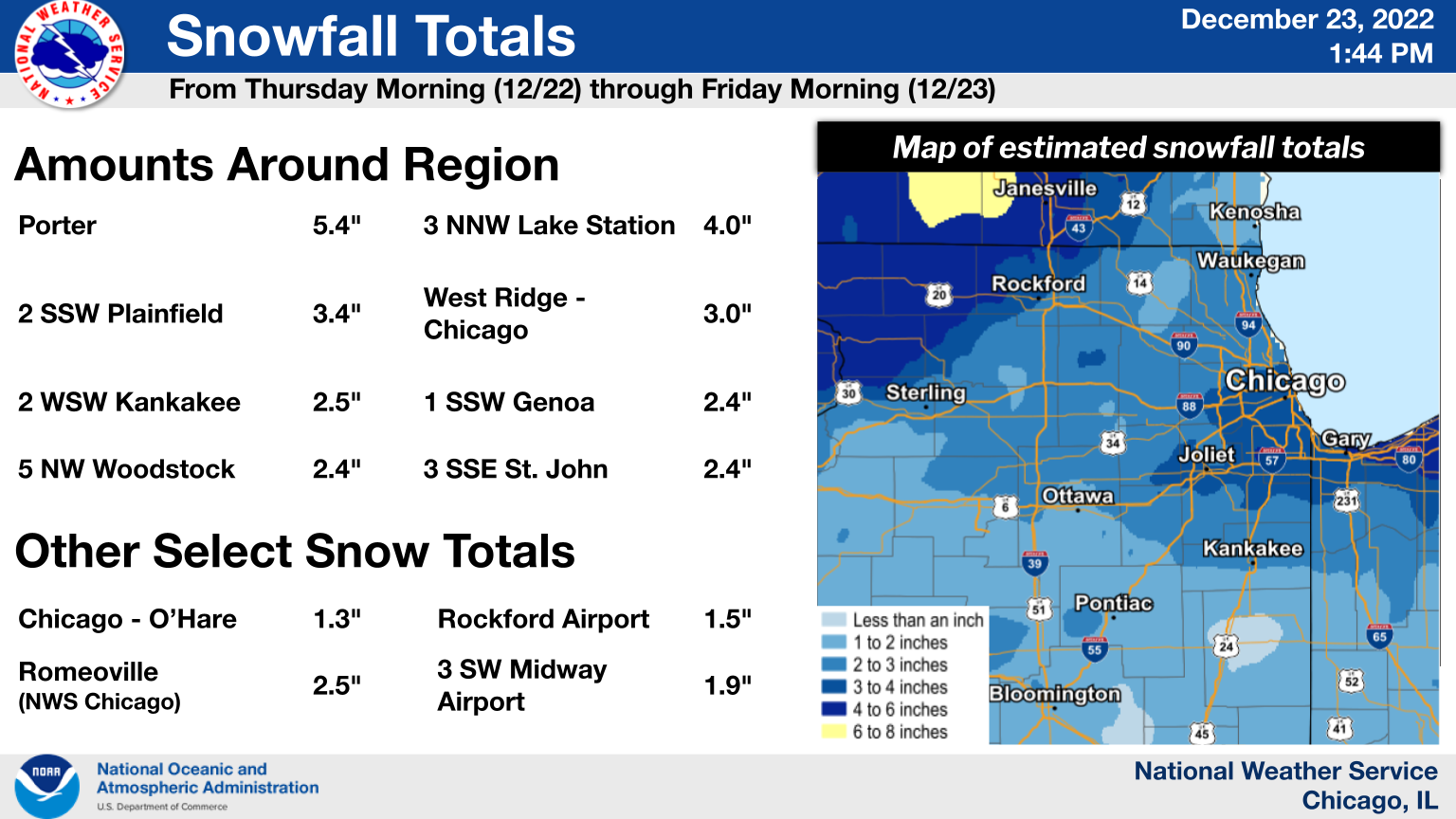 |
| Snowfall summary graphic |
PRELIMINARY LOCAL STORM REPORT...SUMMARY
NATIONAL WEATHER SERVICE CHICAGO IL
1054 AM CST FRI DEC 23 2022
..TIME... ...EVENT... ...CITY LOCATION... ...LAT.LON...
..DATE... ....MAG.... ..COUNTY LOCATION..ST.. ...SOURCE....
..REMARKS..
0700 AM SNOW PORTER 41.62N 87.08W
12/23/2022 M5.4 INCH PORTER IN COCORAHS
COCORAHS STATION IN-PT-69 PORTER.
0630 AM SNOW 2 E CHESTERTON 41.61N 87.03W
12/23/2022 M4.0 INCH PORTER IN COCORAHS
COCORAHS STATION IN-PT-110 CHESTERTON 2 E.
0700 AM SNOW 3 NNW LAKE STATION 41.62N 87.25W
12/23/2022 M4.0 INCH LAKE IN COCORAHS
COCORAHS STATION IN-LK-63 GARY 5 ENE.
0700 AM SNOW 2 SSE PLAINFIELD 41.58N 88.19W
12/23/2022 M3.4 INCH WILL IL COCORAHS
COCORAHS STATION IL-WL-51 PLAINFIELD 2 SSE.
0700 AM SNOW 2 NNE HOMER GLEN 41.63N 87.93W
12/23/2022 M3.2 INCH WILL IL COCORAHS
COCORAHS STATION IL-WL-16 HOMER GLEN 2 NNE.
0700 AM SNOW 2 WSW MOKENA 41.52N 87.92W
12/23/2022 M3.2 INCH WILL IL COCORAHS
COCORAHS STATION IL-WL-97 MOKENA 2 WSW.
0520 AM SNOW OGDEN DUNES 41.62N 87.20W
12/23/2022 M3.0 INCH PORTER IN COCORAHS
COCORAHS STATION IN-PT-157 OGDEN DUNES.
0700 AM SNOW WEST RIDGE - CHICAGO 42.00N 87.70W
12/23/2022 M3.0 INCH COOK IL COCORAHS
COCORAHS STATION IL-CK-94 CHICAGO - WEST
RIDGE.
0700 AM SNOW 1 N VALPARAISO 41.49N 87.06W
12/23/2022 M2.8 INCH PORTER IN COCORAHS
COCORAHS STATION IN-PT-98 VALPARAISO 1 N.
0700 AM SNOW HOMEWOOD 41.56N 87.66W
12/23/2022 M2.6 INCH COOK IL COCORAHS
COCORAHS STATION IL-CK-64 HOMEWOOD.
0800 AM SNOW 1 SSW BURBANK 41.73N 87.78W
12/23/2022 M2.6 INCH COOK IL COCORAHS
COCORAHS STATION IL-CK-211 OAK LAWN 2 WNW.
0600 AM SNOW 2 WSW KANKAKEE 41.11N 87.89W
12/23/2022 M2.5 INCH KANKAKEE IL COCORAHS
COCORAHS STATION IL-KK-45 KANKAKEE 1.4 WSW.
0600 AM SNOW 1 SW LAKE VILLA 42.40N 88.09W
12/23/2022 M2.5 INCH LAKE IL COCORAHS
COCORAHS STATION IL-LK-9 LAKE VILLA 1 SW.
0600 AM SNOW NWS CHICAGO-ROMEOVILLE 41.60N 88.09W
12/23/2022 M2.5 INCH WILL IL CO-OP OBSERVER
CO-OP OBSERVER STATION LOTI2 ROMEOVILLE -
NWS CHICAGO.
0700 AM SNOW PEOTONE 41.33N 87.79W
12/23/2022 M2.5 INCH WILL IL COCORAHS
COCORAHS STATION IL-WL-46 PEOTONE.
0700 AM SNOW CHICAGO RIDGE 41.70N 87.78W
12/23/2022 M2.5 INCH COOK IL COCORAHS
COCORAHS STATION IL-CK-152 CHICAGO RIDGE.
0731 AM SNOW 2 SE HOBART 41.51N 87.23W
12/23/2022 M2.5 INCH LAKE IN COCORAHS
COCORAHS STATION IN-LK-119 HOBART 2.4 SE.
0800 AM SNOW 1 E EVANSTON 42.04N 87.68W
12/23/2022 M2.5 INCH COOK IL COCORAHS
COCORAHS STATION IL-CK-336 EVANSTON 1 E.
0700 AM SNOW 1 SSW GENOA 42.08N 88.71W
12/23/2022 M2.4 INCH DE KALB IL CO-OP OBSERVER
CO-OP OBSERVER STATION GEOI2 GENOA.
0700 AM SNOW 1 NNE PALATINE 42.13N 88.03W
12/23/2022 M2.4 INCH COOK IL COCORAHS
COCORAHS STATION IL-CK-294 PALATINE 1 NNE.
0700 AM SNOW 1 NNE OAK PARK 41.91N 87.78W
12/23/2022 M2.4 INCH COOK IL COCORAHS
COCORAHS STATION IL-CK-74 OAK PARK 1 NNE.
0700 AM SNOW 5 NW WOODSTOCK 42.36N 88.53W
12/23/2022 M2.4 INCH MCHENRY IL CO-OP OBSERVER
CO-OP OBSERVER STATION WODI2 WOODSTOCK 5 NW.
0700 AM SNOW 3 SSE ST. JOHN 41.42N 87.44W
12/23/2022 M2.4 INCH LAKE IN COCORAHS
COCORAHS STATION IN-LK-99 ST. JOHN 3 SSE.
0830 AM SNOW 1 SSE WADSWORTH 42.42N 87.92W
12/23/2022 M2.4 INCH LAKE IL COCORAHS
COCORAHS STATION IL-LK-120 WADSWORTH 1.4 S.
0600 AM SNOW 2 NNW CEDAR LAKE 41.39N 87.46W
12/23/2022 M2.3 INCH LAKE IN COCORAHS
COCORAHS STATION IN-LK-109 CEDAR LAKE 2 NNW.
0625 AM SNOW 1 WSW WHEATON 41.86N 88.12W
12/23/2022 M2.3 INCH DUPAGE IL COCORAHS
COCORAHS STATION IL-DP-184 WHEATON.
0700 AM SNOW 1 SSW LA GRANGE PARK 41.82N 87.88W
12/23/2022 M2.3 INCH COOK IL COCORAHS
COCORAHS STATION IL-CK-98 LA GRANGE PARK 1
SSW.
0700 AM SNOW 4 SW PLAINFIELD 41.57N 88.27W
12/23/2022 M2.3 INCH KENDALL IL COCORAHS
COCORAHS STATION IL-KD-34 PLAINFIELD 4 SW.
0900 AM SNOW 1 NNW BATAVIA 41.87N 88.32W
12/23/2022 M2.3 INCH KANE IL COCORAHS
COCORAHS STATION IL-KN-22 GENEVA 1 SSW.
0700 AM SNOW 1 NE RIVERWOODS 42.17N 87.89W
12/23/2022 M2.1 INCH LAKE IL COCORAHS
COCORAHS STATION IL-LK-39 RIVERWOODS 1 NE.
0700 AM SNOW 1 WSW CREST HILL 41.55N 88.13W
12/23/2022 M2.1 INCH WILL IL CO-OP OBSERVER
CO-OP OBSERVER STATION JKJI2 JOLIET 2 N.
0700 AM SNOW 1 NW BATAVIA 41.86N 88.33W
12/23/2022 M2.1 INCH KANE IL COCORAHS
COCORAHS STATION IL-KN-23 BATAVIA 1 NW.
0730 AM SNOW 1 W MOKENA 41.53N 87.90W
12/23/2022 M2.1 INCH WILL IL COCORAHS
COCORAHS STATION IL-WL-42 MOKENA 1 W.
0600 AM SNOW 1 WSW NAPERVILLE 41.77N 88.16W
12/23/2022 M2.0 INCH DUPAGE IL COCORAHS
COCORAHS STATION IL-DP-156 NAPERVILLE.
0600 AM SNOW 1 N MOROCCO 40.97N 87.45W
12/23/2022 M2.0 INCH NEWTON IN CO-OP OBSERVER
CO-OP OBSERVER STATION MORI3 MOROCCO.
0644 AM SNOW 2 SW WINFIELD 41.85N 88.18W
12/23/2022 M2.0 INCH DUPAGE IL COCORAHS
COCORAHS STATION IL-DP-164 WEST CHICAGO 4
SE.
0700 AM SNOW 3 W ELGIN 42.04N 88.34W
12/23/2022 M2.0 INCH KANE IL COCORAHS
COCORAHS STATION IL-KN-95 ELGIN 3 W.
0700 AM SNOW TROUT VALLEY 42.20N 88.25W
12/23/2022 M2.0 INCH MCHENRY IL COCORAHS
COCORAHS STATION IL-MCH-95 TROUT VALLEY.
0700 AM SNOW 2 WNW LOVES PARK 42.32N 89.09W
12/23/2022 M2.0 INCH WINNEBAGO IL COCORAHS
COCORAHS STATION IL-WN-48 4 NNW ROCKFORD.
0700 AM SNOW 3 NNW HAWTHORN WOODS 42.26N 88.08W
12/23/2022 M2.0 INCH LAKE IL CO-OP OBSERVER
CO-OP OBSERVER STATION MUNI2 MUNDELEIN 4
WSW.
0700 AM SNOW 2 N AURORA 41.78N 88.31W
12/23/2022 M2.0 INCH KANE IL CO-OP OBSERVER
CO-OP OBSERVER STATION ARRI2 AURORA.
0700 AM SNOW 1 W GLEN ELLYN 41.88N 88.09W
12/23/2022 M2.0 INCH DUPAGE IL COCORAHS
COCORAHS STATION IL-DP-132 GLEN ELLYN 1 W.
0700 AM SNOW 4 ESE AURORA 41.73N 88.24W
12/23/2022 M2.0 INCH DUPAGE IL COCORAHS
COCORAHS STATION IL-DP-16 AURORA 4 ESE.
0700 AM SNOW 1 NE PAW PAW 41.70N 88.97W
12/23/2022 M2.0 INCH LEE IL CO-OP OBSERVER
CO-OP OBSERVER STATION PAWI2 PAW PAW 2 S.
0800 AM SNOW 1 NNW MORRIS 41.37N 88.43W
12/23/2022 M2.0 INCH GRUNDY IL CO-OP OBSERVER
CO-OP OBSERVER STATION MOSI2 MORRIS 1 NW.
0800 AM SNOW 1 WNW PARK FOREST 41.49N 87.70W
12/23/2022 M2.0 INCH COOK IL COCORAHS
COCORAHS STATION IL-CK-320 PARK FOREST 1
WNW.
0800 AM SNOW 4 ESE AURORA 41.74N 88.23W
12/23/2022 M2.0 INCH DUPAGE IL COCORAHS
COCORAHS STATION IL-KN-115 AURORA 4 ESE.
0800 AM SNOW 1 ENE ST. CHARLES 41.92N 88.30W
12/23/2022 M2.0 INCH KANE IL COCORAHS
COCORAHS STATION IL-KN-64 ST. CHARLES 1 ENE.
0800 AM SNOW 2 WSW GOODENOW 41.38N 87.68W
12/23/2022 M2.0 INCH WILL IL COCORAHS
COCORAHS STATION IL-WL-149 MONEE 5 SE.
0845 AM SNOW 1 NNE PERU 41.35N 89.12W
12/23/2022 M2.0 INCH LA SALLE IL COCORAHS
COCORAHS STATION IL-LS-60 PERU 1 NNE.
0600 AM SNOW 1 WSW BURBANK 41.74N 87.78W
12/23/2022 M1.9 INCH COOK IL CO-OP OBSERVER
CO-OP OBSERVER STATION MFWI2 MIDWAY 3 SW.
0700 AM SNOW 2 N BUFFALO GROVE 42.19N 87.96W
12/23/2022 M1.9 INCH LAKE IL COCORAHS
COCORAHS STATION IL-LK-16 BUFFALO GROVE 2 N.
0700 AM SNOW 2 WNW GENEVA 41.89N 88.33W
12/23/2022 M1.9 INCH KANE IL COCORAHS
COCORAHS STATION IL-KN-121 GENEVA 2 WNW.
0700 AM SNOW MARENGO 42.26N 88.60W
12/23/2022 M1.8 INCH MCHENRY IL COCORAHS
COCORAHS STATION IL-MCH-87 MARENGO.
0700 AM SNOW 3 N CARBON HILL 41.34N 88.30W
12/23/2022 M1.8 INCH GRUNDY IL CO-OP OBSERVER
CO-OP OBSERVER STATION CTYI2 COAL CITY 4
NNW.
0700 AM SNOW 1 ESE VILLA PARK 41.88N 87.96W
12/23/2022 M1.8 INCH DUPAGE IL COCORAHS
COCORAHS STATION IL-DP-178 VILLA PARK.
0700 AM SNOW 3 N CARBON HILL 41.34N 88.30W
12/23/2022 M1.8 INCH GRUNDY IL COCORAHS
COCORAHS STATION IL-GY-1 CARBON HILL 3 N.
0710 AM SNOW 1 N MEDINAH 42.00N 88.05W
12/23/2022 M1.8 INCH COOK IL COCORAHS
COCORAHS STATION IL-CK-75 ELK GROVE VILLAGE
2 WSW.
0700 AM SNOW 2 W BOURBONNAIS 41.17N 87.92W
12/23/2022 M1.7 INCH KANKAKEE IL CO-OP OBSERVER
CO-OP OBSERVER STATION BOUI2 BOURBONNAIS.
0700 AM SNOW 1 SSW INDIAN HEAD PARK 41.76N 87.90W
12/23/2022 M1.7 INCH COOK IL COCORAHS
COCORAHS STATION IL-CK-358 INDIAN HEAD PARK.
0700 AM SNOW 2 WSW PALOS PARK 41.65N 87.86W
12/23/2022 M1.7 INCH COOK IL COCORAHS
COCORAHS STATION IL-CK-50 PALOS PARK 2 WSW.
0700 AM SNOW 1 SW DEKALB 41.92N 88.76W
12/23/2022 M1.7 INCH DE KALB IL COCORAHS
COCORAHS STATION IL-DK-28 DEKALB.
0700 AM SNOW 4 ESE AURORA 41.73N 88.24W
12/23/2022 M1.7 INCH DUPAGE IL COCORAHS
COCORAHS STATION IL-DP-101 AURORA 4 ESE.
0700 AM SNOW 3 NNW CARBON HILL 41.33N 88.31W
12/23/2022 M1.7 INCH GRUNDY IL COCORAHS
COCORAHS STATION IL-GY-16 CARBON HILL 3 NNW.
0730 AM SNOW 1 NW COLLEGEVILLE 40.92N 87.18W
12/23/2022 M1.7 INCH JASPER IN CO-OP OBSERVER
CO-OP OBSERVER STATION RZZI3 RENSSELAER 2
SW.
0800 AM SNOW 1 E BANNOCKBURN 42.19N 87.85W
12/23/2022 M1.7 INCH LAKE IL COCORAHS
COCORAHS STATION IL-LK-118 HIGHLAND PARK 2.1
WNW.
0700 AM SNOW BANNOCKBURN 42.19N 87.86W
12/23/2022 M1.6 INCH LAKE IL COCORAHS
COCORAHS STATION IL-LK-15 BANNOCKBURN.
0700 AM SNOW 1 SW TIMBERLANE 42.32N 88.88W
12/23/2022 M1.6 INCH BOONE IL COCORAHS
COCORAHS STATION IL-BN-19 TIMBERLANE 1 SW.
0700 AM SNOW 2 W MORRIS 41.35N 88.45W
12/23/2022 M1.6 INCH GRUNDY IL COCORAHS
COCORAHS STATION IL-GY-28 MORRIS 2 W.
0500 AM SNOW 1 N PARK FOREST 41.50N 87.68W
12/23/2022 M1.5 INCH COOK IL CO-OP OBSERVER
CO-OP OBSERVER STATION PKFI2 PARK FOREST.
0600 AM SNOW CORTLAND 41.92N 88.69W
12/23/2022 M1.5 INCH DE KALB IL COCORAHS
COCORAHS STATION IL-DK-5 CORTLAND.
0600 AM SNOW COLLEGEVILLE 40.91N 87.16W
12/23/2022 M1.5 INCH JASPER IN COCORAHS
COCORAHS STATION IN-JS-7 COLLEGEVILLE.
0630 AM SNOW 3 N NEW LENOX 41.56N 87.96W
12/23/2022 M1.5 INCH WILL IL COCORAHS
COCORAHS STATION IL-WL-180 MOKENA 4 WNW.
0700 AM SNOW 5 SSW NAPERVILLE 41.71N 88.17W
12/23/2022 M1.5 INCH WILL IL COCORAHS
COCORAHS STATION IL-WL-92 NAPERVILLE 5 SSW.
0700 AM SNOW 1 SSW FOREST LAKE 42.19N 88.07W
12/23/2022 M1.5 INCH LAKE IL CO-OP OBSERVER
CO-OP OBSERVER STATION LKZI2 FOREST LAKE 1
SSW.
0700 AM SNOW 1 E PALATINE 42.11N 88.02W
12/23/2022 M1.5 INCH COOK IL COCORAHS
COCORAHS STATION IL-CK-121 PALATINE 1 E.
0700 AM SNOW 1 ESE PROSPECT HEIGHTS 42.10N 87.90W
12/23/2022 M1.5 INCH COOK IL COCORAHS
COCORAHS STATION IL-CK-42 MOUNT PROSPECT 3
NE.
0700 AM SNOW 4 ENE MILFORD 40.66N 87.64W
12/23/2022 M1.5 INCH IROQUOIS IL COCORAHS
COCORAHS STATION IL-IR-25 MILFORD 3.5 ENE.
0700 AM SNOW 4 NNE BOONE GROVE 41.41N 87.10W
12/23/2022 M1.5 INCH PORTER IN COCORAHS
COCORAHS STATION IN-PT-117 BOONE GROVE 4
NNE.
0730 AM SNOW 1 WNW BRIDGEVIEW 41.76N 87.82W
12/23/2022 M1.5 INCH COOK IL COCORAHS
COCORAHS STATION IL-CK-12 BRIDGEVIEW 1 WNW.
0730 AM SNOW 2 SE DARIEN 41.73N 87.95W
12/23/2022 M1.5 INCH DUPAGE IL COCORAHS
COCORAHS STATION IL-DP-79 DARIEN 2 SE.
0700 AM SNOW 2 W AURORA 41.76N 88.35W
12/23/2022 M1.4 INCH KANE IL COCORAHS
COCORAHS STATION IL-KN-123 AURORA 2 W.
0700 AM SNOW CLARENDON HILLS 41.80N 87.95W
12/23/2022 M1.4 INCH DUPAGE IL CO-OP OBSERVER
CO-OP OBSERVER STATION WJWI2 CLARENDON
HILLS.
0745 AM SNOW OAK LAWN 41.71N 87.75W
12/23/2022 M1.4 INCH COOK IL COCORAHS
COCORAHS STATION IL-CK-149 OAK LAWN.
0800 AM SNOW 2 SSE BARRINGTON HILLS 42.12N 88.16W
12/23/2022 M1.4 INCH COOK IL CO-OP OBSERVER
CO-OP OBSERVER STATION BARI2 BARRINGTON.
0800 AM SNOW FRANKLIN PARK 41.93N 87.87W
12/23/2022 M1.4 INCH COOK IL COCORAHS
COCORAHS STATION IL-CK-345 FRANKLIN PARK 0.5
SSE.
0530 AM SNOW 1 NNW ALGONQUIN 42.17N 88.30W
12/23/2022 M1.3 INCH MCHENRY IL COCORAHS
COCORAHS STATION IL-MCH-43 ALGONQUIN 1 NNW.
0700 AM SNOW 4 NNE HARVARD 42.48N 88.58W
12/23/2022 M1.3 INCH MCHENRY IL COCORAHS
COCORAHS STATION IL-MCH-103 HARVARD 4.4 NNE.
0700 AM SNOW 1 NW PALATINE 42.13N 88.06W
12/23/2022 M1.3 INCH COOK IL COCORAHS
COCORAHS STATION IL-CK-346 PALATINE 1.2 NW.
0700 AM SNOW 1 SSW GENEVA 41.87N 88.31W
12/23/2022 M1.3 INCH KANE IL COCORAHS
COCORAHS STATION IL-KN-127 GENEVA.
0731 AM SNOW 1 NW OTTAWA 41.36N 88.86W
12/23/2022 M1.3 INCH LA SALLE IL COCORAHS
COCORAHS STATION IL-LS-1 OTTAWA.
0600 AM SNOW BATAVIA 41.85N 88.31W
12/23/2022 M1.2 INCH KANE IL CO-OP OBSERVER
CO-OP OBSERVER STATION BATI2 BATAVIA.
0600 AM SNOW 1 NNW DEMOTTE 41.21N 87.21W
12/23/2022 M1.2 INCH JASPER IN COCORAHS
COCORAHS STATION IN-JS-37 DEMOTTE.
0700 AM SNOW 2 E SCHAUMBURG 42.03N 88.04W
12/23/2022 M1.2 INCH COOK IL COCORAHS
COCORAHS STATION IL-CK-131 SCHAUMBURG 2 E.
0730 AM SNOW MOUNT PROSPECT 42.07N 87.94W
12/23/2022 M1.2 INCH COOK IL COCORAHS
COCORAHS STATION IL-CK-367 MOUNT PROSPECT
0.2 NNE.
0800 AM SNOW 1 SE NEW LENOX 41.50N 87.95W
12/23/2022 M1.2 INCH WILL IL COCORAHS
COCORAHS STATION IL-WL-147 NEW LENOX 1 SE.
0830 AM SNOW 1 SSE LIBERTYVILLE 42.27N 87.95W
12/23/2022 M1.2 INCH LAKE IL COCORAHS
COCORAHS STATION IL-LK-127 LIBERTYVILLE 1.6
SE.
0700 AM SNOW 1 ESE SPRING GROVE 42.44N 88.22W
12/23/2022 M1.1 INCH MCHENRY IL COCORAHS
COCORAHS STATION IL-MCH-108 SPRING GROVE 1.2
ESE.
0700 AM SNOW 1 NNE HOMER GLEN 41.61N 87.93W
12/23/2022 M1.1 INCH WILL IL COCORAHS
COCORAHS STATION IL-WL-131 HOMER GLEN 1 NNE.
0600 AM SNOW 4 SW VALPARAISO 41.43N 87.11W
12/23/2022 M1.0 INCH PORTER IN COCORAHS
COCORAHS STATION IN-PT-12 VALPARAISO 4 SW.
0700 AM SNOW LONG LAKE 42.37N 88.12W
12/23/2022 M1.0 INCH LAKE IL COCORAHS
COCORAHS STATION IL-LK-100 LONG LAKE.
0700 AM SNOW FOX LAKE HILLS 42.41N 88.12W
12/23/2022 M1.0 INCH LAKE IL COCORAHS
COCORAHS STATION IL-LK-81 FOX LAKE HILLS.
0700 AM SNOW CHATSWORTH 40.75N 88.29W
12/23/2022 M1.0 INCH LIVINGSTON IL CO-OP OBSERVER
CO-OP OBSERVER STATION CHTI2 CHATSWORTH.
0700 AM SNOW 1 ESE ELK GROVE VILLAGE 42.00N 87.98W
12/23/2022 M1.0 INCH COOK IL COCORAHS
COCORAHS STATION IL-CK-63 ELK GROVE VILLAGE
1 ESE.
0700 AM SNOW 2 S WOODRIDGE 41.73N 88.04W
12/23/2022 M1.0 INCH DUPAGE IL COCORAHS
COCORAHS STATION IL-DP-102 BOLINGBROOK 3 NE.
0700 AM SNOW 4 NE FAIR OAKS 41.11N 87.20W
12/23/2022 M1.0 INCH JASPER IN COCORAHS
COCORAHS STATION IN-JS-31 DE MOTTE 6 S.
0700 AM SNOW CHATSWORTH 40.75N 88.29W
12/23/2022 M1.0 INCH LIVINGSTON IL COCORAHS
COCORAHS STATION IL-LV-7 CHATSWORTH 0.4 ESE.
0733 AM SNOW 1 ENE NORTH AURORA 41.82N 88.31W
12/23/2022 M1.0 INCH KANE IL COCORAHS
COCORAHS STATION IL-KN-33 NORTH AURORA 1
ENE.
0740 AM SNOW 2 W NAPLATE 41.33N 88.91W
12/23/2022 M1.0 INCH LA SALLE IL CO-OP OBSERVER
CO-OP OBSERVER STATION OTTI2 OTTAWA -
BUFFALO ROCK SP.
0800 AM SNOW GENEVA 41.88N 88.30W
12/23/2022 M1.0 INCH KANE IL COCORAHS
COCORAHS STATION IL-KN-133 GENEVA.
0900 AM SNOW REMINGTON 40.77N 87.15W
12/23/2022 M1.0 INCH JASPER IN COCORAHS
COCORAHS STATION IN-JS-47 REMINGTON.
|
Links
Summaries from Adjacent NWS Offices:
Additional Links:
 |
Media use of NWS Web News Stories is encouraged! Additional recaps can be found on the NWS Chicago Science & Past Events Page. |
|


.png)